Mori Atlas logo
Nature reserveLingegebied & Diefdijk-Zuid

A fragmented Natura 2000 protected area defined by the Linge river and historic Dutch water management

Lingegebied & Diefdijk-Zuid Nature Reserve: Geographic Map and Protected Landscape Context

Lingegebied & Diefdijk-Zuid represents a specialized Natura 2000 nature reserve located across the Dutch provinces of Gelderland, Utrecht, and Zuid-Holland. This protected area consists of several non-contiguous habitat parcels linked by the river Linge and the historic Diefdijk defensive dike. The surrounding terrain is shaped by classic river valley characteristics, including polders, meadows, and managed waterways that anchor the region's ecological coherence.

Natura 2000river landscaperiver LingeDiefdijkpoldersmeadows

Lingegebied & Diefdijk-Zuid

Nature reserve

Park overview

Structured park overview, official facts, and landscape profile for Lingegebied & Diefdijk-Zuid

Lingegebied & Diefdijk-Zuid park facts, protected area profile, and essential visitor context

Review the core facts for Lingegebied & Diefdijk-Zuid, including designation, size, terrain, visitor scale, habitats, and operating context in one park-focused overview.

About Lingegebied & Diefdijk-Zuid

Lingegebied & Diefdijk-Zuid is a Dutch Natura 2000 protected area composed of several separated parcels situated in and around the basin of the river Linge. The Linge is a small, winding river in the central Netherlands that flows through a region historically shaped by river flooding, peatland drainage, and small-scale farming. The Natura 2000 designation draws together a number of these smaller habitat patches into one coherent protected unit, even though they are physically separated by the river itself or by roads and built-up areas.

Geographically, the site lies in the heart of the Dutch river country, covering parts of Gelderland, Utrecht, and Zuid-Holland. Within these provinces it extends into four municipalities: Gorinchem on the southern edge of the area, Molenlanden to the north, Vijfheerenlanden in the west, and West Betuwe in the central and eastern portion. The Dutch name reflects this composite structure, with "Lingegebied" referring to the broader Linge river area and "Diefdijk-Zuid" naming the southern section of the historic Diefdijk dike line, a defining cultural and hydrological feature of the region.

The site was formally designated on 4 June 2013 and carries the national area number 70. Its European site code is NL3004007, and it falls under the European Habitats Directive rather than the Birds Directive. With a total area of approximately 7.50 square kilometers, it is a relatively modest Natura 2000 site by surface area, but its position within the wider network of Dutch protected areas near the rivers Waal, Linge, and Lek gives it meaningful ecological context in the river landscape of the central Netherlands.

Quick facts and research context for Lingegebied & Diefdijk-Zuid

Lingegebied & Diefdijk-Zuid is Natura 2000 site number 70 in the Netherlands, with the European site code NL3004007. It was designated on 4 June 2013 and falls under the European Habitats Directive rather than the Birds Directive. Its total protected surface is approximately 7.50 square kilometers.

The site spans three provinces, Gelderland, Utrecht, and Zuid-Holland, and reaches into four municipalities: Gorinchem, Molenlanden, Vijfheerenlanden, and West Betuwe. It is a composite area made up of separate habitat parcels rather than a single continuous reserve, and it has no Natura 2000 sites directly adjoining it.

Protection and recognition

Documented terrestrial protection scope and conservation designation records

Lingegebied & Diefdijk-Zuid Protection Status and International Recognition

Lingegebied & Diefdijk-Zuid features documented terrestrial protection status and recorded administrative boundaries. Structured conservation records outline official management scope and international recognition without unverified claims.

Protection details

Protection scope
Terrestrial
Transboundary protection
No
Park context

Deeper park guide and search-rich context for Lingegebied & Diefdijk-Zuid

Lingegebied & Diefdijk-Zuid history, landscape, wildlife, and travel context

Explore Lingegebied & Diefdijk-Zuid through its history, landscape character, ecosystems, wildlife, conservation priorities, cultural context, and seasonal travel timing in a structured park guide built for atlas discovery and search intent.

Why Lingegebied & Diefdijk-Zuid stands out

Lingegebied & Diefdijk-Zuid is best known as a fragmented Natura 2000 site whose identity is tightly bound to the river Linge and its surroundings. Rather than relying on a single iconic landscape, the area is recognized for tying together multiple smaller, separated habitat patches within the river-influenced countryside of central Netherlands. The site is also notable for straddling three provinces and four municipalities, making it one of the more administratively composite Natura 2000 areas in the Dutch network. Its formal designation in 2013 placed it firmly within the framework of protected European habitats.

Lingegebied & Diefdijk-Zuid landscape and geographic character

The physical setting of Lingegebied & Diefdijk-Zuid is defined by the gentle topography of the Dutch river plain. The river Linge itself, a relatively small and slow-moving tributary-like watercourse in the central Netherlands, runs through the broader landscape and serves as both a unifying thread and a dividing element, since several Natura 2000 parcels within the area lie on different sides of the river.

The surrounding terrain is shaped by centuries of water management, including the historic Diefdijk, an old defensive dike line that runs through the area and lends part of its name to the southern portion of the Natura 2000 site. The country around the Linge consists of a patchwork of polders, small farmlands, meadows, ditches, and wooded edges, characteristic of the traditional cultural landscape of the Betuwe and the Vijfheerenlanden. Because the protected area is split into separate parcels rather than forming one large continuous stretch, the landscape character changes from one fragment to another as one moves across the river or crosses into a different municipality.

Lingegebied & Diefdijk-Zuid ecosystems, habitats, and plant life

As a Natura 2000 site designated under the European Habitats Directive, Lingegebied & Diefdijk-Zuid contributes to the protection of habitat types that are characteristic of the central Dutch river landscape. Although the Dutch-language source material does not enumerate specific habitat types in detail, the area's position along and around the river Linge, combined with its mix of polders, meadows, and dike-influenced terrain, points to a nature profile shaped by moist, river-associated habitats and the traditional rural land uses of the region.

The fact that the site is a composite of several separated parcels, each embedded in a different stretch of the Linge basin, also gives it a varied ecological character. Wetland-influenced patches, small woodlands along old dike lines, and species-rich meadows are typical elements of this type of river-edge Natura 2000 site in the Netherlands.

Lingegebied & Diefdijk-Zuid conservation status and protection priorities

Lingegebied & Diefdijk-Zuid was formally designated as a Natura 2000 area on 4 June 2013, placing it within the European Union's framework for protecting natural habitats and associated species. As a Habitats Directive site, its conservation role is focused on maintaining or restoring the favorable condition of specific habitat types within the wider Dutch network of protected areas.

Although the site covers only about 7.50 square kilometers and is split across multiple parcels, its conservation significance comes from its contribution to the ecological coherence of the Linge river area, including the southern section of the historic Diefdijk dike line. The designation ensures that land use, water management, and any potential developments affecting these parcels must be assessed in light of their protected habitat values.

Top sights and standout views in Lingegebied & Diefdijk-Zuid

Lingegebied & Diefdijk-Zuid stands out within the Dutch Natura 2000 network for being a clearly composite area: a Natura 2000 site built from several separate habitat parcels linked by their shared relationship to the Linge river landscape and the Diefdijk dike line.

The site also draws attention for crossing three provinces and four municipalities, a relatively unusual administrative spread for a protected area of just a few square kilometers. Its 2013 designation under the Habitats Directive, combined with its European site code NL3004007, confirms its place as a formally recognized component of the European protected-area network in the central Netherlands.
Monthly climate preview

Long-term monthly temperature and precipitation data measured across the park coordinate

Lingegebied and Diefdijk-Zuid Climate Normals and Temperature Patterns

Representative point measurements from 1991 to 2020 record the annual progression of average temperatures and daily precipitation across Lingegebied and Diefdijk-Zuid. Complete monthly climate statistics provide deeper insight into temperature ranges and precipitation totals throughout the year.
Annual mean10 °C
2 °C18 °C
Jan
Feb
Mar
Apr
May13°
Jun16°
Jul18°
Aug18°
Sep15°
Oct11°
Nov
Dec
Warmest month
July

18.2 °C

Coolest month
January

2.5 °C

Wettest month
December

2.6 mm/day

Driest month
April

1.4 mm/day

Park location guide

Geography guide, regional context, and park location map for Lingegebied & Diefdijk-Zuid

Lingegebied & Diefdijk-Zuid park geography, regions, and map view in Netherlands

Understand where Lingegebied & Diefdijk-Zuid sits in Netherlands through a broader geographic reading of the surrounding landscape, nearby location context, and its mapped position within the national park landscape.

How Lingegebied & Diefdijk-Zuid fits into Netherlands

The Netherlands is a low-lying coastal country in Northwestern Europe, famous for its extensive dike and canal systems that reclaim land from the sea. It consists of twelve provinces and is known for tulips, windmills, and cycling culture. The country is a founding member of the European Union with Amsterdam as its capital and The Hague as the seat of government.

Wider geography shaping Lingegebied & Diefdijk-Zuid in Netherlands

The Netherlands is located in Northwestern Europe along the North Sea coastline to the north and west. It borders Germany to the east and Belgium to the south. The country is notably flat, with a significant portion of its territory lying below sea level, protected by dikes and dune systems. It consists of twelve provinces and also includes overseas municipalities in the Caribbean.

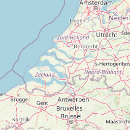
Map view of Lingegebied & Diefdijk-Zuid

Use this park location map to pinpoint Lingegebied & Diefdijk-Zuid in Netherlands, understand its exact geographic position, and read its mapped placement within the surrounding landscape more clearly.

Pigeon | © OpenStreetMap contributors

Location context for Lingegebied & Diefdijk-Zuid

GelderlandUtrechtZuid-Holland
Park atlas

Compare adjacent river landscapes, polder habitats, and regional Dutch nature reserves.

Parks near Lingegebied & Diefdijk-Zuid and Surrounding Protected Areas

Browsing other protected areas near Lingegebied & Diefdijk-Zuid reveals broader ecological patterns across the central Dutch river plain. Comparing adjacent river habitats and polder landscapes provides essential context for regional conservation networks.
A horizontal watercolor painting of a winding river flowing through a lush, green countryside with soft trees and a pale, pastel-colored sky.
Nature reserveGelderland
About 5.2 km away#1 closest

South

Loevestein, Pompveld & Kornsche Boezem: Regional Geography and Protected Area Mapping

A composite Natura 2000 network in the central Dutch river delta.

Spanning the Bommelerwaard and Land van Heusden en Altena, Loevestein, Pompveld & Kornsche Boezem represents a vital approach to protecting fragmented lowland habitats. This record provides geographic insight into the diverse riverine mosaic of floodplains, wet grasslands, and historical stream channels that define this protected landscape in the heart of the Netherlands.

Area
7.5 km²
Established
2013
Watercolor illustration showing a network of rivers, trees, and hills in a wetland landscape
National parkNetherlands
About 15 km away#2 closest

Southwest

De Biesbosch National Park: A Dutch National Park Mapping Tidal Wetlands and Flood Forests

Explore mapped waterways and diverse protected landscapes.

Delve into the geography of De Biesbosch National Park, a remarkable protected area in the Netherlands renowned for its extensive freshwater tidal wetlands. This national park showcases a unique landscape defined by intricate river systems, dominant willow flood forests, and vital reed beds, serving as a critical habitat for migratory birds and a prime example of wetland restoration. Understand its place within the regional geography through our atlas-driven approach to protected land discovery.

Area
90 km²
Established
1994
IUCN
II
Relief
Lowland
Watercolor illustration of rolling hills, a winding river, and fields with distant mountains
National parkNorth Brabant
About 21 km away#3 closest

South

Van Gogh National Park: National Park in North Brabant with Dune Landscapes

Explore mapped protected areas and regional geography.

Van Gogh National Park is a significant protected landscape in North Brabant, Netherlands, covering approximately 1,200 square kilometers. This national park is distinguished by its extensive drift sand dune systems, notable heathlands, and wooded valleys, offering a diverse terrain within the Dutch context. Named in tribute to Vincent van Gogh, it merges rich natural landscapes with cultural heritage, serving as a model for collaborative conservation and regional development, all mapped for detailed atlas exploration.

Area
1,200 km²
Established
2024
IUCN
II
Relief
Lowland
Watercolor artwork showing sand dunes, scattered trees, distant mountains, and soft sky
National parkNetherlands
About 22 km away#4 closest

South

De Loonse en Drunense Duinen National Park: Explore Dutch Protected Sand Drift Landscapes and Heathlands

National Park with unique living sand drift and dune terrain.

Navigate the geographic contours and protected land boundaries of De Loonse en Drunense Duinen National Park, a premier Dutch natural area. This national park is celebrated for its extensive living sand drift, one of the largest in Northern Europe, alongside significant heathlands and coniferous forests. Gain a structured understanding of its landscape character and its role within regional geography through detailed map context and atlas exploration tools.

Area
35 km²
Established
2002
IUCN
II
Relief
Lowland
Watercolor painting of a lush, green landscape with ferns and grasses in the foreground and a soft, hazy forest line in the background.
Protected areaNetherlands
About 24 km away#5 closest

Northeast

Kolland en Overlangbroek: Mapping the Rare Ash Floodplain Forest of the Netherlands

Historic estate landscape and protected woodland habitat.

Located between Wijk bij Duurstede and the Utrechtse Heuvelrug, Kolland en Overlangbroek preserves a vital fragment of alluvial ash forest. This protected area offers deep insight into Dutch floodplain geography, featuring a distinct mosaic of sandy ridges, silty backswamps, and centuries-old woodland managed for its unique bryophyte flora and groundwater-fed ecosystem.

Area
1.1 km²
Relief
Lowland
Climate
Temperate
Scope
Terrestrial
Watercolor landscape showing green hills, forests, and a small stream with grassy patches
National parkUtrecht Province
About 30 km away#6 closest

Northeast

Utrechtse Heuvelrug National Park: Mapped Protected Landscape and Geographic Atlas

Discover Utrecht Province's glacial ridge and diverse natural terrain.

Utrechtse Heuvelrug National Park is a significant protected natural area located in Utrecht Province, renowned for its unique glacial ridge topography. This entry provides detailed information about its mapped boundaries, diverse landscapes including heathlands and forests, and its importance as an ecological corridor within the Netherlands. Explore the park's distinct geography and its role in regional conservation through our structured atlas view.

Area
100 km²
Established
2003
IUCN
II
Visitors
1M annual
A watercolor painting showing a soft, idyllic landscape with rolling hills in the background, a winding path or stream in the middle ground, and grasses and trees in the foreground.
Nature reserveGelderland
About 37 km away#7 closest

Northeast

Binnenveld Nature Reserve: Protected Wetland and Meadowland in Gelderland

Rare blue grasslands and stream valley quaking bogs

Located in the Gelderse Vallei, Binnenveld stands as a vital nature reserve representing the complex history of Dutch polder landscapes. The area combines traditional meadowland with strictly protected habitats like the Bennekomse Meent, serving as a haven for meadow birds and an important site for ecological restoration and wetland preservation.

Area
1.11 km²
Established
2014
Relief
Lowland
Climate
Temperate
Protected areaNetherlands
About 42 km away#8 closest

Northeast

Veluwe: A Comprehensive Geographic Atlas of the Central Netherlands Protected Area

Glacial moraines, heathlands, and inland sand systems

Investigate the Veluwe, a premier protected area in the Gelderland province characterized by its historic push moraines and extensive ecological zones. The region encompasses significant sand drift complexes, dense woodlands, and vital spring-fed streams, offering a clear view of the diverse natural terrain found throughout the central Netherlands.

Area
1,000 km²
Relief
Upland
Climate
Temperate
Access
Easy access

Common questions about visiting, size, designation, and location context for Lingegebied & Diefdijk-Zuid

Lingegebied & Diefdijk-Zuid FAQs for park facts, access, geography, and protected area context

Find quick answers about Lingegebied & Diefdijk-Zuid, including protected-area facts, park geography, trail and visitor context, and how the park fits into its surrounding country and regional landscape.
MoriAtlas Explorer

Continue Your Protected Areas Search Across the Global Atlas

Deepen your exploration by continuing the structured search for national parks and protected areas worldwide. Utilize the comprehensive filtering capabilities to compare different conservation landscapes and refine your understanding of global park geography. Discover more about the distribution and characteristics of protected natural areas.

Global natural geography