Mori Atlas logo
National parkDe Biesbosch National Park

Mapping the extensive waterways, willow flood forests, and rich bird habitats of a crucial European wetland.

De Biesbosch National Park: Netherlands' Premier Freshwater Tidal Wetland and Protected Landscape

(Nationaal Park De Biesbosch)

De Biesbosch National Park represents one of Northwestern Europe's most significant and rare freshwater tidal wetland ecosystems. Situated across North Brabant and South Holland, its landscape is a complex network of rivers, creeks, and islands shaped by history and ongoing ecological restoration. This national park offers a unique opportunity to explore vast willow flood forests, dynamic reed beds, and open water bodies, providing critical habitats for migratory waterfowl and other wildlife.

wetlandsriver deltafreshwater ecosystemsbirdwatchingnature reservesprotected area
Illustration of a river scene with willow trees, reeds, and cliffs under a sunset sky with birds flying

De Biesbosch National Park

National park

Park overview

Structured park overview, official facts, and landscape profile for De Biesbosch National Park

De Biesbosch National Park park facts, protected area profile, and essential visitor context
Review the core facts for De Biesbosch National Park, including designation, size, terrain, visitor scale, habitats, and operating context in one park-focused overview.

About De Biesbosch National Park

De Biesbosch National Park represents a remarkable confluence of natural history, human tragedy, and modern conservation ambition in the Netherlands. The park occupies a landscape that was fundamentally transformed in November 1421 when the St. Elizabeth flood breached the dikes of the Grote Hollandse Waard, a fertile agricultural region containing numerous villages. Over the following decades, the flooded area evolved into a complex network of estuaries, channels, and mudflats fed by the Rhine and Meuse rivers, eventually becoming the distinctive freshwater tidal environment known as the Biesbosch. This catastrophic event, which according to tradition destroyed 72 villages and claimed thousands of lives, created one of the most ecologically valuable wetlands in Western Europe. Today, the park provides a rare glimpse of how the Dutch river delta appeared before centuries of systematic reclamation and flood control transformed most of the lowland landscape. The park's management balances multiple objectives including nature conservation, water management, drinking water supply through the spaarbekkens reservoir system, and sustainable recreation. The ongoing 'Room for the River' program is gradually returning reclaimed areas to the park, reestablishing natural hydrological connections and expanding wildlife habitat.

Quick facts and research context for De Biesbosch National Park

De Biesbosch National Park covers approximately 90 square kilometers across the Dutch provinces of North Brabant and South Holland. The park was established in 1994 and is managed by Staatsbosbeheer, the Dutch state forestry commission. The area consists of three main sections: the Sliedrechtse Biesbosch in the north with the most significant remaining tidal influence, the Hollandse Biesbosch in the west known for its birdlife, and the Brabantse Biesbosch (Zuidwaard) in the east comprising the largest portion of the park. The park contains several artificial reservoirs known as spaarbekkens that serve the regional drinking water supply, storing water diverted from the Meuse River. The area holds Ramsar Convention protection status since 1980 and is part of the European Natura 2000 network of protected areas.

Park context

Deeper park guide and search-rich context for De Biesbosch National Park

De Biesbosch National Park history, landscape, wildlife, and travel context
Explore De Biesbosch National Park through its history, landscape character, ecosystems, wildlife, conservation priorities, cultural context, and seasonal travel timing in a structured park guide built for atlas discovery and search intent.

Why De Biesbosch National Park stands out

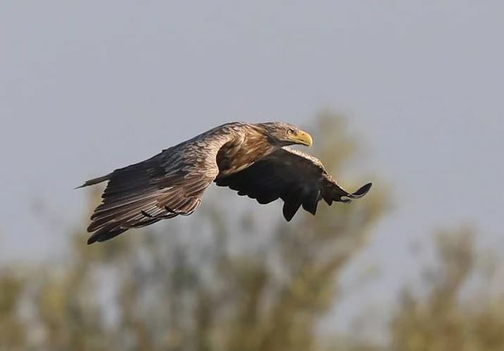
De Biesbosch is best known as one of Northwestern Europe's most significant freshwater tidal wetland ecosystems, a rare habitat type that has largely disappeared from the region due to centuries of flood control and land reclamation. The park is renowned for its extensive willow flood forests that dominate the landscape, creating a hauntingly beautiful environment of waterways, mudflats, and forested islands. The area is particularly famous for its bird populations, especially migratory waterfowl including geese, and has become a notable location for observing sea eagles, ospreys, and an increasing variety of wading birds. The park also contains one of the few remaining intact systems of river dunes in the Netherlands within the Sliedrechtse Biesbosch section. The successful reintroduction of European beavers and the recent return of otters have made De Biesbosch an important model for wetland restoration and ecosystem recovery in lowland Europe.

Wide river with calm water flowing through grassy banks under a clear sky
River landscape in De Biesbosch National Park

De Biesbosch National Park history and protected-area timeline

The creation of De Biesbosch began with one of the most devastating flood disasters in Dutch history. In November 1421, the dikes of the Grote Hollandse Waard collapsed during a combination of severe storm surge and high river levels. The floodwaters submerged approximately 300 square kilometers of cultivated land, destroying by tradition 72 villages and either 2,000 or 10,000 lives. The disaster occurred during a period of political instability when maintenance of the dikes had been neglected due to the Hook and Cod wars. Over the following decades, the flooded area evolved from an open inland sea into a complex delta system characterized by interconnected channels, mudflats, and emerging islands colonized by reeds and willows. For centuries, the Biesbosch functioned as a dynamic tidal wetland with tidal differences of up to two meters, supporting traditional occupations including reed harvesting, willow coppice management (griend cultivation), fishing, and fowling. Major hydrological changes in the nineteenth and twentieth centuries, including the creation of the artificial Nieuwe Merwede river and the closure of the Haringvliet in 1970 as part of the Delta Works, fundamentally altered the ecosystem by eliminating the tidal connection to the sea. During World War II, the complex network of creeks, reed beds, and willow forests provided crucial hiding places for Dutch resistance fighters and refugees fleeing German occupation. The 'Biesbosch crossers' who smuggled people, messages, and medicines across the waterways are regarded as national heroes. Contemporary history has seen significant restoration efforts, including the reintroduction of beavers and plans to partially re-establish tidal influences.

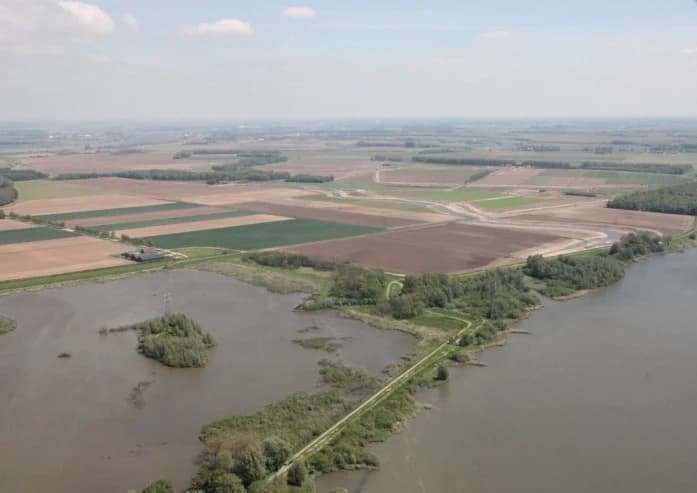
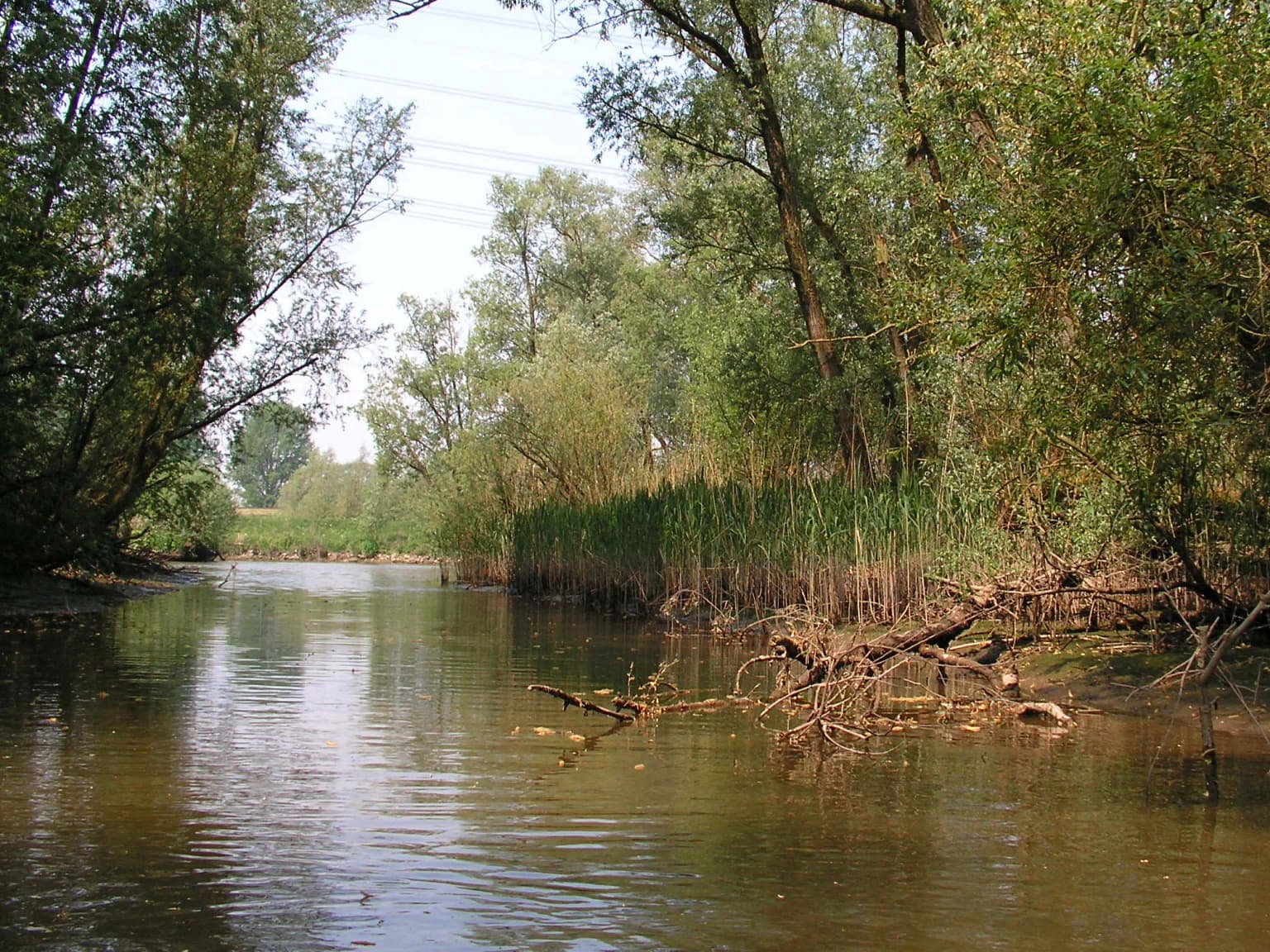
De Biesbosch National Park landscape and geographic character

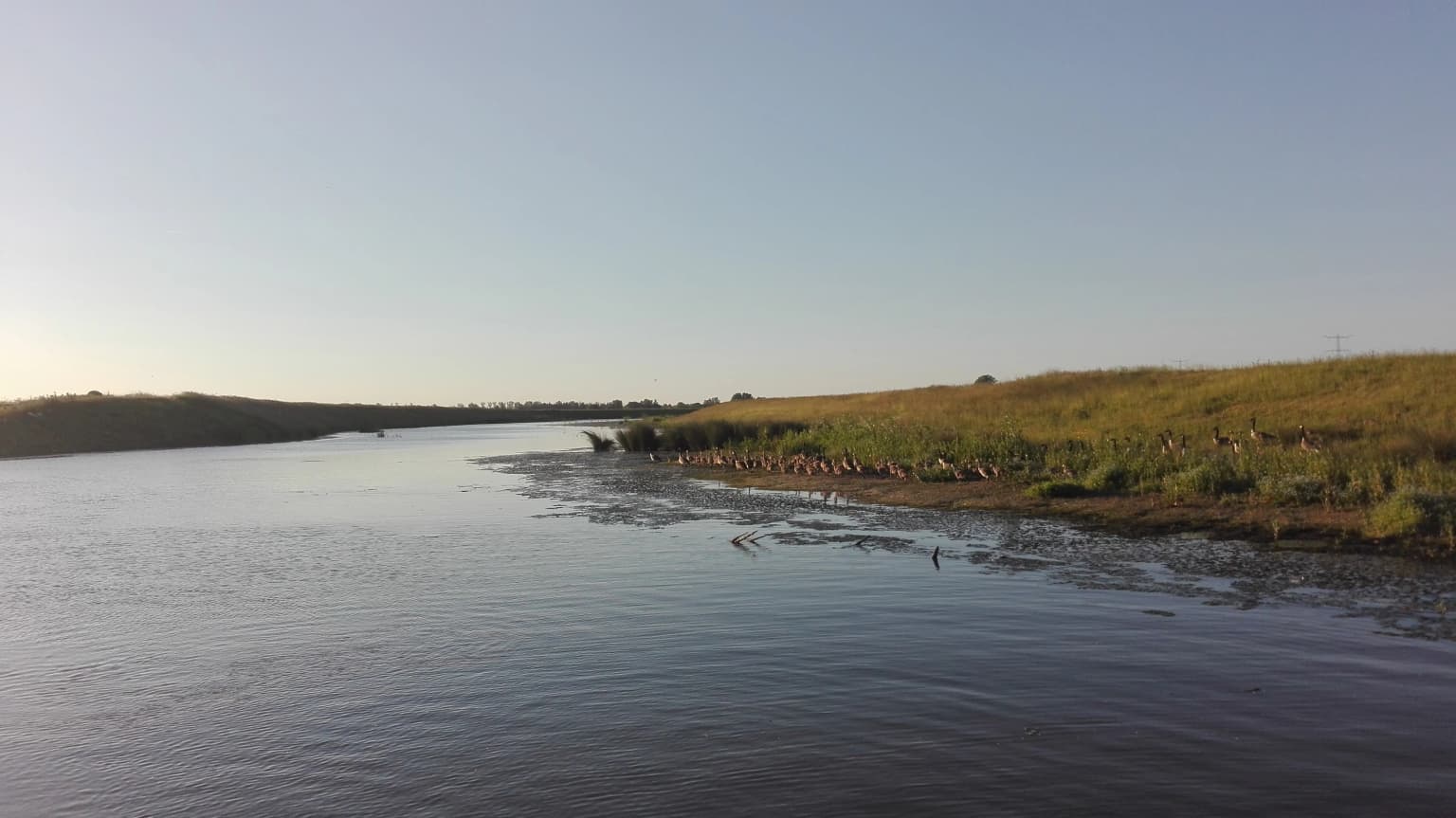
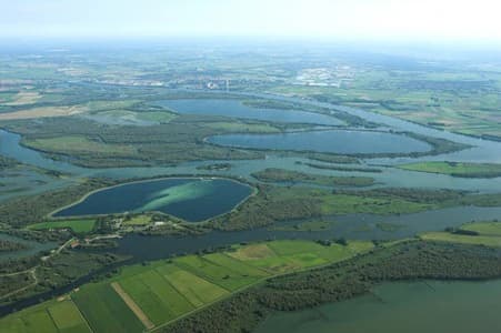
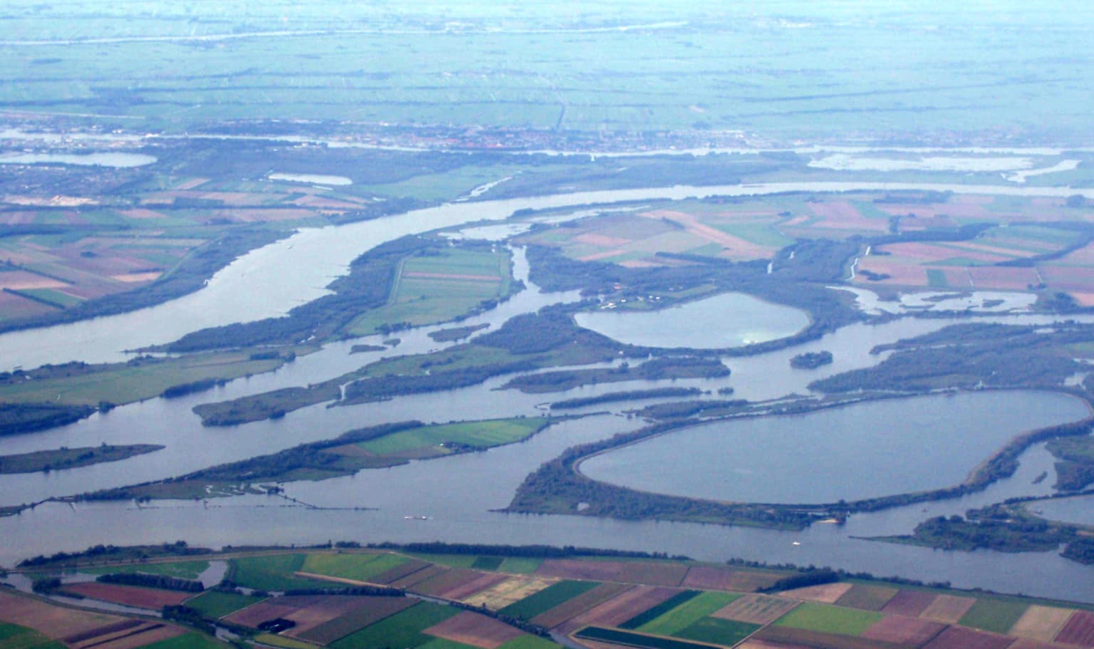
The physical landscape of De Biesbosch is defined by its network of rivers, creeks, and islands set within a low-lying delta environment. The terrain is almost entirely flat, with elevation differences measured in meters rather than hundreds of meters, reflecting the Dutch lowland character. The park contains numerous waterways ranging from major distributary channels like the Nieuwe Merwede to smaller creeks and Killen that dissect the land into a complex pattern of islands and marshy areas. The eastern section of the Sliedrechtse Biesbosch contains one of the few remaining intact systems of river dunes in the Netherlands, a rare geological feature in this otherwise flat landscape. The vegetation creates distinct landscape zones: open water and mudflats in the most dynamic areas, extensive reed beds on higher ground, and willow-dominated flood forests that have expanded dramatically since the reduction of tidal influence in 1970. The three artificial reservoirs known as spaarbekkens (Petrusplaat, Honderd en Dertig, and De Gijster) add distinctive open water bodies to the landscape while serving crucial drinking water supply functions. The park's landscape continues to evolve as restoration projects return former agricultural polders to wetland conditions, reestablishing the natural patterns of flooding and sedimentation that characterized this area for centuries before modern engineering controls.

Aerial view showing wetland areas with water channels, adjacent agricultural fields, and a river in the distance
Aerial view of the Nieuwe Noordwaard wetlands with the Nieuwe Merwede river in the background

De Biesbosch National Park ecosystems, habitats, and plant life

The ecological character of De Biesbosch is defined by its freshwater wetland habitats that have developed under the complex interplay of river influence, tidal dynamics, and human management over centuries. The dominant vegetation consists of willow forests that have expanded significantly since the reduction of tidal action following the closure of the Haringvliet in 1970. These willow flood forests, many of which originated as cultivated griend (willow coppice) before reverting to wild woodland, now form extensive wooded areas interspersed with reed beds and wet grasslands. The park's designation as a Ramsar wetland and Natura 2000 site recognizes its international importance for maintaining biodiversity in freshwater tidal ecosystems. The transition zone between fresh and brackish water conditions that historically characterized the Biesbosch created unique ecological niches, though the closure of the sea connection has shifted the ecosystem toward freshwater dominance. Ongoing restoration efforts aim to re-establish more natural hydrological dynamics, including the planned partial opening of the Haringvlietdam sluices to restore some tidal influence and improve conditions for migratory fish species.

White-tailed eagle with spread wings flying against a blurred background of trees
White-tailed eagle in flight over De Biesbosch National Park

De Biesbosch National Park wildlife and species highlights

De Biesbosch supports a rich wildlife community characteristic of Dutch freshwater wetlands, with particularly important populations of waterfowl, birds of prey, and increasingly, large mammals. The park is renowned for its birdlife, with over 100 breeding bird species recorded, including significant populations of grebes, herons, egrets, ducks, and marsh birds. The area is especially important for migratory geese, with large flocks using the wetlands as resting and feeding areas during seasonal migrations. Raptors have become a particular highlight, with sea eagles (white-tailed eagles) breeding in the park since 2014 and ospreys establishing themselves as breeding birds in 2016. The mammal community has undergone remarkable changes following reintroduction programs: European beavers were introduced in 1988, 1989, and 1999, with populations now expanding significantly across the park. Otters, once common in the area before the 1970s, returned to the Biesbosch in 2023 after decades of absence, representing a major conservation success. The park also supports populations of red deer, fallow deer, and expanding communities of large grazing animals including Scottish Highland cattle and Konik horses that help maintain open wetland habitats through conservation grazing.

Aerial view of interconnected waterways and reservoirs surrounded by green fields and forests
Aerial view of reservoirs and wetland landscapes in De Biesbosch National Park

De Biesbosch National Park conservation status and protection priorities

De Biesbosch represents one of the most significant conservation stories in the Netherlands, demonstrating how degraded wetland ecosystems can be restored through dedicated protection and active management. The park's designation as a Ramsar wetland in 1980 and its inclusion in the European Natura 2000 network recognizes its international importance for biodiversity conservation. The transformation from a tidal to a freshwater-dominated system following the Delta Works created significant ecological challenges, leading to the decline of migratory fish species and the homogenization of habitats. However, recent conservation initiatives are reversing these trends: the 'Room for the River' program has returned former agricultural polders to wetland conditions, expanding the park's area and reconnecting waterways to restore natural hydrological processes. The partial opening of the Haringvlietdam sluices (the 'Kierbesluit') aims to restore some tidal dynamics and enable migratory fish species including salmon, trout, and shad to return to the rivers. Conservation challenges remain significant, particularly legacy pollution in sediments from the heavily industrialized Rhine and Meuse Rivers of the 1960s and 1970s, and the need to balance recreational use with ecological protection.

De Biesbosch National Park cultural meaning and human context

The cultural landscape of De Biesbosch is deeply shaped by its dramatic origins in the catastrophic flood of 1421, an event that fundamentally transformed both the physical environment and the regional identity. The area was historically known as the Verdronken Waard (Drowned Land) or Bergsche Veld before the name Biesbosch came into common use during the eighteenth century, reflecting the colonization of the emerging islands by sedge and willow vegetation. Traditional occupations including reed cutting, willow coppice management (griend cultivation), fishing, and bird hunting shaped the landscape for centuries and created unique cultural practices. The area gained additional historical significance during World War II when its complex network of waterways provided refuge for resistance fighters and a means of escaping occupied territory. The Biesbosch crossers who facilitated these dangerous passages are celebrated in Dutch history and literature. The park also contains important infrastructure for contemporary Dutch water management, including the spaarbekkens that store water from the Meuse River for drinking water supply to Rotterdam, parts of North Brabant, and Zeeland.

Aerial photograph of De Biesbosch National Park with a network of rivers and wetlands surrounded by agricultural fields
Aerial view of De Biesbosch National Park showing its network of rivers and wetlands

Top sights and standout views in De Biesbosch National Park

De Biesbosch offers visitors an exceptional combination of wetland wilderness, wildlife observation opportunities, and cultural history within one of Europe's most densely populated regions. The park's network of waterways provides excellent canoeing and boat-based exploration, with several visitor centers offering boat tours and canoe rentals. Birdwatching is a major draw, with the Hollandse Biesbosch particularly renowned for its avian diversity and four dedicated bird observation hides positioned in key habitats. The beaver population can be observed during evening tours that offer opportunities to see these industrious mammals in their wetland environment. The Biesbosch MuseumEiland in Werkendam provides comprehensive information about the park's natural and cultural history in an architecturally distinguished building. The park's ongoing restoration story, where farmland is being returned to wetland and rivers reconnected to their floodplains, offers visitors the chance to witness active ecological recovery in progress.

A calm waterway with trees and reeds along the banks, showing typical wetland vegetation in De Biesbosch National Park
Calm waterway surrounded by dense vegetation in De Biesbosch National Park

Best time to visit De Biesbosch National Park

The Biesbosch can be visited throughout the year, with each season offering distinct experiences. Spring brings the return of migratory birds including ospreys and the breeding season for waterfowl, while autumn sees large gatherings of geese using the wetlands as staging areas before continuing their migrations. The winter months offer excellent opportunities for wildlife observation, particularly for sea eagles that are more visible when leaves have fallen from the willow forests. Summer provides the most comfortable conditions for exploring the waterways by boat or canoe, though this is also the peak period for recreational use. The Sliedrechtse Biesbosch retains some tidal influence (20-80 cm), creating dynamic water level changes that are most pronounced during the winter months. Regardless of season, the park's atmosphere is heavily influenced by weather conditions, with fog and moody skies adding to the wetland's evocative character.

Park location guide

Geography guide, regional context, and park location map for De Biesbosch National Park

De Biesbosch National Park park geography, regions, and map view in Netherlands
Understand where De Biesbosch National Park sits in Netherlands through a broader geographic reading of the surrounding landscape, nearby location context, and its mapped position within the national park landscape.

How De Biesbosch National Park fits into Netherlands

The Netherlands is a low-lying coastal country in Northwestern Europe, famous for its extensive dike and canal systems that reclaim land from the sea. It consists of twelve provinces and is known for tulips, windmills, and cycling culture. The country is a founding member of the European Union with Amsterdam as its capital and The Hague as the seat of government.

Wider geography shaping De Biesbosch National Park in Netherlands

The Netherlands is located in Northwestern Europe along the North Sea coastline to the north and west. It borders Germany to the east and Belgium to the south. The country is notably flat, with a significant portion of its territory lying below sea level, protected by dikes and dune systems. It consists of twelve provinces and also includes overseas municipalities in the Caribbean.

Map view of De Biesbosch National Park

Use this park location map to pinpoint De Biesbosch National Park in Netherlands, understand its exact geographic position, and read its mapped placement within the surrounding landscape more clearly.

Pigeon | © OpenStreetMap contributors

Location context for De Biesbosch National Park

North BrabantSouth Holland

See the protected freshwater delta, willow forests, and wetland habitats of De Biesbosch.

De Biesbosch National Park: Visualizing Freshwater Wetland Landscapes and Protected Area Scenery
Explore an extensive collection of De Biesbosch National Park photos, revealing its unique freshwater tidal wetlands, complex river delta geography, and characteristic willow flood forests. These images provide essential visual context for understanding the park's distinct ecological character, significant bird habitats, and the overall protected-area environment.

Wide river with calm water flowing through grassy banks under a clear sky

Flooded forest scene with water covering ground and tree reflections in calm water

Aerial view showing wetland areas with water channels, adjacent agricultural fields, and a river in the distance

White-tailed eagle with spread wings flying against a blurred background of trees

Aerial view of interconnected waterways and reservoirs surrounded by green fields and forests

A wide view of a water basin with grassy islands and distant trees under a cloudy sky

Aerial photograph of De Biesbosch National Park with a network of rivers and wetlands surrounded by agricultural fields

A calm waterway with trees and reeds along the banks, showing typical wetland vegetation in De Biesbosch National Park

A calm river surrounded by dense green trees and reeds, reflecting the sky and vegetation in the water

A large tree with dense foliage stands in a marshy area with tall reeds and calm water

Sunset over a river with reeds in the foreground and distant tree line

Wide view of a calm creek with trees on both sides, overcast sky

Concrete bridge with green railing over a river surrounded by dense green vegetation

Wide view of De Biesbosch National Park showing a river, grassy meadows, reeds, and trees under an overcast sky with a bird in flight

A calm river surrounded by tall grasses, reeds, and purple wildflowers with trees in the background under a dark sky

Highland cattle grazing in tall grass near a body of water

Park atlas

Trace the geographic spread of wetland ecosystems and diverse protected areas across the Dutch lowlands.

Explore National Parks and Protected Areas Near De Biesbosch National Park, Netherlands
Browse a curated atlas of national parks and protected areas adjacent to De Biesbosch National Park, showcasing wetland ecosystems and river delta landscapes across the Netherlands. This focused geographic view helps compare varied conservation landscapes and identify shared ecological features, illuminating their regional spread within this critical delta environment.
Watercolor artwork showing sand dunes, scattered trees, distant mountains, and soft sky
National park

De Loonse en Drunense Duinen National Park: Explore Dutch Protected Sand Drift Landscapes and Heathlands

National Park with unique living sand drift and dune terrain.

Navigate the geographic contours and protected land boundaries of De Loonse en Drunense Duinen National Park, a premier Dutch natural area. This national park is celebrated for its extensive living sand drift, one of the largest in Northern Europe, alongside significant heathlands and coniferous forests. Gain a structured understanding of its landscape character and its role within regional geography through detailed map context and atlas exploration tools.

Area
35 km²
Established
2002
IUCN
II
Relief
Lowland
Watercolor illustration of rolling hills, a winding river, and fields with distant mountains
National parkNorth Brabant

Van Gogh National Park: National Park in North Brabant with Dune Landscapes

Explore mapped protected areas and regional geography.

Van Gogh National Park is a significant protected landscape in North Brabant, Netherlands, covering approximately 1,200 square kilometers. This national park is distinguished by its extensive drift sand dune systems, notable heathlands, and wooded valleys, offering a diverse terrain within the Dutch context. Named in tribute to Vincent van Gogh, it merges rich natural landscapes with cultural heritage, serving as a model for collaborative conservation and regional development, all mapped for detailed atlas exploration.

Area
1,200 km²
Established
2024
IUCN
II
Relief
Lowland
National park

De Zoom, Kalmthoutse Heide Cross-Border Park: Transboundary National Park & Heathland Atlas

Explore mapped protected boundaries and regional geography.

This page details the De Zoom, Kalmthoutse Heide Cross-Border Park, a significant national park that merges Belgian and Dutch protected territories. It is recognized for its expansive heathland, a crucial ecosystem in the Benelux region, offering a rich visual and ecological study. The park's mapped landscape context reveals its unique geography, from dry heathlands to Ramsar-designated wetlands, providing valuable insight for atlas-based exploration of protected areas. Understand the park's protected area identity and its role within the regional landscape.

Area
37.5 km²
Established
2001
IUCN
II
Watercolor landscape showing green hills, forests, and a small stream with grassy patches
National parkUtrecht Province

Utrechtse Heuvelrug National Park: Mapped Protected Landscape and Geographic Atlas

Discover Utrecht Province's glacial ridge and diverse natural terrain.

Utrechtse Heuvelrug National Park is a significant protected natural area located in Utrecht Province, renowned for its unique glacial ridge topography. This entry provides detailed information about its mapped boundaries, diverse landscapes including heathlands and forests, and its importance as an ecological corridor within the Netherlands. Explore the park's distinct geography and its role in regional conservation through our structured atlas view.

Area
100 km²
Established
2003
IUCN
II
Visitors
1M annual
Watercolor illustration of a coastal landscape with marshy areas, calm water, and distant hills
National parkZeeland

Oosterschelde National Park: A Dynamic Tidal Marine Ecosystem in Zeeland, Netherlands

Explore the geography of Netherlands' largest protected tidal landscape.

Oosterschelde National Park represents a unique intersection of natural dynamism and human engineering within the Zeeland province. As the Netherlands' largest national park, it safeguards a vast tidal lagoon system characterized by its profound tidal flats and sandbanks that transform landscape twice daily. This protected area offers a remarkable case study in coastal geography and marine conservation, with its rich ecosystems supporting diverse wildlife and providing excellent opportunities for sport diving and birdwatching. Delve into the mapped context of this significant Dutch protected landscape.

Area
370 km²
Established
2002
IUCN
II
Relief
Lowland
Watercolor depiction of rolling coastal dunes, blue waterways, green vegetation, and distant hills under a light sky
National parkNorth Holland

Zuid-Kennemerland National Park: Coastal Dune Protected Landscape in North Holland

Explore its unique mapped terrain and protected area geography.

Zuid-Kennemerland National Park showcases a remarkable coastal dune ecosystem situated in the North Holland province. This national park entry provides detailed insight into its protected landscape, from calcium-rich dune soils supporting rare flora to ancient woodlands and extensive walking trails. Users can explore the park's mapped boundaries, understand its geographic setting within the Netherlands, and appreciate its significance as a conservation area. Discover the natural terrain and ecological richness that characterize this important Dutch protected land.

Area
38 km²
Established
1995
IUCN
II
Visitors
1.8M annual
Watercolor painting of rolling hills, green trees, and a winding path
National parkGelderland

De Hoge Veluwe National Park: Mapped Protected Landscape & Geographic Atlas Context

Explore Gelderland's unique heathland, sand dune, and woodland terrain.

De Hoge Veluwe National Park represents a distinctive protected area within the Gelderland region of the Netherlands. Its landscape is characterized by a unique mosaic of heathlands, sand dunes, and woodlands, shaped by ice age processes and historical land use. This page offers an atlas-focused exploration of its geographic setting, mapped boundaries, and the specific terrain that defines this significant natural and cultural heritage site.

Area
55 km²
Established
1935
IUCN
II
Visitors
629.4K annual
Watercolor painting of a peat bog ecosystem featuring green trees, pink and yellow vegetation, a body of water, and distant mountains
National park

De Groote Peel National Park: Mapped Boundaries of a Unique Raised Bog & Wetland

Protected area with exceptional birdlife and peat landscape.

De Groote Peel National Park represents a crucial protected landscape in the Netherlands, renowned as one of the last substantial raised bogs in Western Europe. Its terrain is characterized by a distinct blend of open lakes formed by historical peat extraction, heathland expanses, and sensitive peat swamps. This Ramsar-designated wetland is a vital habitat for numerous bird species, offering unique opportunities for landscape context and atlas exploration of its ecological significance and mapped geographic features.

Area
13.4 km²
Established
1993
IUCN
II
Relief
Lowland

Common questions about visiting, size, designation, and location context for De Biesbosch National Park

De Biesbosch National Park FAQs for park facts, access, geography, and protected area context
Find quick answers about De Biesbosch National Park, including protected-area facts, park geography, trail and visitor context, and how the park fits into its surrounding country and regional landscape.
MoriAtlas Explorer

Continue Your Protected Areas Search Across the Global Atlas

Deepen your exploration by continuing the structured search for national parks and protected areas worldwide. Utilize the comprehensive filtering capabilities to compare different conservation landscapes and refine your understanding of global park geography. Discover more about the distribution and characteristics of protected natural areas.

Global natural geography