
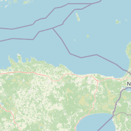
Peninsulas
Park geography
Analyzing the protected land boundaries, coastal span, and boreal landscape characteristics.
Structured Geographic Profile and Mapped Terrain of Lahemaa National Park in Estonia
This geographic profile details the physical extent of Lahemaa National Park across its 747 square kilometer recorded boundary. Data includes the distribution of land and marine territory, specific coastal features like capes and waterfalls, and the composition of boreal forest and wetland habitats within the lowland terrain.
Related tags
Boreal ForestsRaised BogsCoastal PeninsulaHistoric ManorsLarge Mammals
Estonia's premier protected wilderness where ancient bogs, coastal cliffs, and historic manors meet
Lahemaa National Park
Lahemaa National Park is Estonia's first and largest national park, established in 1971 as the inaugural protected area of the former Soviet Union. Located in northern Estonia, approximately 70 kilometers east of the capital Tallinn, the park stretches along the southern coast of the Gulf of Finland and encompasses a remarkable diversity of landscapes including four prominent peninsulas—Juminda, Pärispea, Käsmu, and Vergi—separated by four distinct bays. The name Lahemaa translates from Estonian as "Land of Bays," accurately reflecting the region's deeply indented coastline stretching about 145 kilometers within the park boundaries. With an area of 747 square kilometers, including roughly 275 square kilometers of marine waters, it ranks among the largest national parks in Europe and serves as a flagship for Baltic conservation.
- Location
- Estonia
- Park type
- National park
- Established
- 1971
- Area
- 747 km²
Location overview
Coastal and Marine Protected Area Boundaries within Estonia
Geographic Positioning of Lahemaa National Park in Estonia
Lahemaa National Park is situated entirely within the national borders of Estonia. The protected area features significant coastal and marine territory under single-country jurisdiction.
- Countries
- Estonia
- Primary location
- Estonia
- Geographic setting
- Coastal · Marine
Boundary and coordinates
Interactive boundary geometry and measured spatial dimensions
Lahemaa National Park Boundary Map and Geographic Extent
Mapped park outlines provide complete spatial context for analyzing protected territory. Accompanying measurements detail land and marine areas alongside coordinate extents and geographic spans.
- Boundary area
- 747.7 km²
- Boundary perimeter
- 183.6 km
- Northernmost point
- 59.7117° N
- Southernmost point
- 59.4543° N
- Easternmost point
- 26.2681° E
- Westernmost point
- 25.455° E
- Geographic centre
- 59.5735° N, 25.8048° E
- North–south span
- 28.7 km
- East–west span
- 45.9 km
Terrain and natural features
Stored lowland relief classifications and recorded physical features
Lahemaa National Park Terrain Geography and Named Natural Features
Recorded terrain classifications indicate lowland relief across the protected landscape alongside multiple documented stones, capes, streams, and beaches. Linked feature cards supply specific types, measurements, and spatial relationships within the territory.
Selected named natural features
Named stones
Kiviheinamaa kivi
Named stones
Suurkivi
Streams
Marjametsa oja
Capes
Kuissäär
Beaches
Laiakari rand
Environmental setting
Boreal climate zones and coastal lowland forest habitats across recorded terrain
Lahemaa National Park Environmental Settings and Landscape Classifications
Recorded landscape features and habitat types provide complementary ways to read the physical setting of this protected area. Stored environmental categories connect directly to related atlas destinations and mapped regional geographies.
- Relief
- Lowland
- Climate
- Boreal
- Water
- Major water bodies
- Forest cover
- Mostly forested
Landscape features
Coast · Bog · Forest · Rivers · Cliffs · Wetland
Habitat types
Temperate broadleaf forest · Boreal forest · Wetland · Riverine habitat · Coastal habitat
Park atlas
Trace the geographic spread of protected landscapes surrounding Lahemaa and compare nearby Baltic conservation areas.
Discover National Parks and Protected Areas Beyond Lahemaa National Park, Estonia's Baltic Coasts
Continue your exploration from Lahemaa National Park to browse a curated selection of other national parks and protected areas in the surrounding Baltic region. Compare diverse protected landscapes, mapped geography, and conservation efforts across similar boreal forests, coastal ecosystems, and historic territories adjacent to Estonia's largest park.
National parkUusimaa
68 km away#1 closest
North

Sipoonkorpi National Park: Protected Landscape and Geography in Uusimaa
Explore Finland's key national park and its natural terrain.
Discover Sipoonkorpi National Park, a vital protected landscape in Finland's Uusimaa region. This page offers detailed insight into its mapped boundaries, diverse boreal forests, extensive swamp areas, and the unique terrain that defines this significant natural area. Understand its role as one of the last undeveloped green spaces near the Helsinki metropolitan area and explore its geographic context within southern Finland.
- Area
- 18.57 km²
- Established
- 2011
- IUCN
- II
- Visitors
- 165.5K annual
National parkUusimaa
79 km away#2 closest
Northwest
Nuuksio National Park: Uusimaa Region Protected Landscape Atlas Entry
Mapped boundaries and geographic context for a Finnish National Park.
Access detailed geographic information and mapped boundaries for Nuuksio National Park, a protected national park within the Uusimaa region. This MoriAtlas entry provides context for understanding its landscape within Finland, focusing on atlas-style exploration and the identification of protected natural areas.
- Area
- 53 km²
- Established
- 1994
- IUCN
- II
- Visitors
- 312.6K annual
National parkEstonia
About 79 km away#3 closest
Southeast

Alutaguse National Park: Eastern Estonia's Vast Peat Bog and Forest Protected Landscape
Mapping Protected Wetlands and Boreal Ecosystems in Estonia
Alutaguse National Park, a newly established national park in eastern Estonia, offers a unique atlas perspective on extensive peat bog ecosystems and boreal forests. Covering over 443 square kilometers, it represents some of the most intact wetland landscapes in the country. The park's creation unified eleven protected areas, safeguarding a critical habitat for rare species and showcasing the distinctive geography of the Alutaguse Lowland.
- Area
- 443.31 km²
- Established
- 2018
- IUCN
- II
- Relief
- Lowland
National parkKymenlaakso
About 95 km away#4 closest
Northeast
Eastern Gulf of Finland National Park: Kymenlaakso's National Park and Coastal Geography
Explore protected lands and mapped terrain.
The Eastern Gulf of Finland National Park is a designated national park located in the Kymenlaakso region of southeastern Finland. This entry provides specific geographic context for the park, detailing its role as a protected landscape and its mapped boundaries within the coastal atlas of the Gulf of Finland. Understanding its regional setting within Kymenlaakso allows for a more structured exploration of Finland's protected natural areas and their unique geographic identities.
- Area
- 6 km²
- Established
- 1982
- IUCN
- II
- Visitors
- 15.8K annual
National parkViljandi County
101 km away#5 closest
South
Soomaa National Park: Estonia's Wilderness Wetland Landscape Atlas
Explore mapped protected peat bogs and dynamic floodplains in Viljandi County.
Soomaa National Park is a protected wilderness area in Estonia renowned for its extensive peat bog systems and unique floodplains. This national park, located primarily in Viljandi County, showcases some of Europe's largest intact wetland landscapes, characterized by seasonal floods that transform the terrain into vast aquatic environments. MoriAtlas provides detailed geographic context for Soomaa, allowing for exploration of its protected boundaries and landscape features within the broader atlas of European natural areas.
- Area
- 359 km²
- Established
- 1993
- IUCN
- II
- Relief
- Lowland
National parkKymenlaakso
105 km away#6 closest
Northeast
Valkmusa National Park: Protected Area Atlas & Kymenlaakso Geography
Mapped natural landscape context within southeastern Finland.
Valkmusa National Park offers a unique opportunity for structured exploration of Finland's protected areas. Within the Kymenlaakso region, this national park presents a specific geographic identity for map-based discovery. Understand its protected landscape, mapped terrain, and regional context to build a comprehensive picture of southeastern Finland's natural geography through MoriAtlas.
- Area
- 17 km²
- Established
- 1996
- IUCN
- II
- Visitors
- 20.3K annual
National parkUusimaa
About 116 km away#7 closest
West
Ekenäs Archipelago National Park: Mapped Baltic Sea Archipelago Landscape
Protected marine area with island geography in Uusimaa, Finland.
Delve into the unique protected landscape of Ekenäs Archipelago National Park, a premier example of a Baltic Sea marine protected area. Located in the Uusimaa region, this national park encompasses a vast expanse of coastal waters dotted with hundreds of rocky islets and skerries. MoriAtlas provides detailed geographic context, allowing for exploration of its mapped boundaries, island formations, and critical role as a sanctuary for breeding aquatic birds. Understand its place within Finland's protected areas atlas and appreciate its distinctive marine archipelago character.
- Area
- 52 km²
- Established
- 1989
- IUCN
- II
- Visitors
- 53.6K annual
National parkLääne County
117 km away#8 closest
Southwest
Matsalu National Park: Explore Estonia's Premier Wetland National Park Geography and Protected Area
Discover mapped landscapes and bird migration routes in Lääne County.
Matsalu National Park, located in Lääne County, Estonia, is a prime example of a protected wetland ecosystem of international significance. This page delves into the park's unique geographic features, including the shallow brackish Matsalu Bay, the expansive Kasari River delta, and the numerous islands that form its coastal mosaic. Users can explore the park's protected boundaries and understand its critical function as a major staging area for migratory birds, offering a detailed atlas-level view of this important natural landscape.
- Area
- 486.1 km²
- Established
- 1957
- IUCN
- II
- Relief
- Lowland
MoriAtlas Explorer
Continue Exploring Lahemaa National Park's Mapped Protected Landscape and Coastline
Deepen your understanding of Lahemaa National Park by exploring its detailed geographic context and protected landscape features. MoriAtlas provides a structured view of this significant Estonian national park, enabling focused discovery of its mapped terrain, unique bog ecosystems, and dramatic coastal formations. Continue your atlas exploration to grasp the full scope of its protected lands and regional geographic significance.
Browse next
Global natural geography
Explore related park routes
Explore MoriAtlas Global ParksBrowse All MoriAtlas ParksGlobal Park Map DiscoveryMoriAtlas: Browse All CountriesBrowse All MoriAtlas ContinentsNational Park Environment AtlasGrand Canyon National Park AtlasYellowstone National Park AtlasYosemite National Park Atlas and GeographySerengeti National Park AtlasGalápagos National Park Protected LandscapeBanff National Park Geography and AtlasKruger National Park Atlas EntryUluṟu-Kata Tjuṯa National Park AtlasExplore Uluru-Kata Tjuta National Park GeographyPlitvice Lakes National Park AtlasFiordland National Park Protected LandscapeGreat Smoky Mountains National Park AtlasAfghanistan National Parks and Protected AreasAlbania National Parks and Protected AreasAlgeria National Parks and Protected AreasAmerican Samoa National Parks and Protected AreasAndorra National Parks and Protected AreasAngola National Parks and Protected AreasAntarctica National Parks and Protected AreasAntigua and Barbuda Park List