
Islands
Park geography
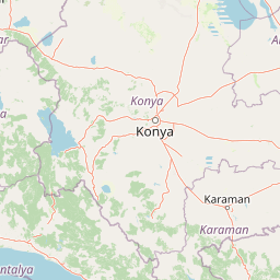
Spatial analysis covering regional administrative context, terrain, and natural features
Comprehensive Geographic Profile and Mapped Boundaries of Lake Beyşehir National Park
Examine the detailed physical landscape of Lake Beyşehir National Park in Turkey. This structured profile maps the regional geography within Konya Province, covering the 868.55 square kilometer expanse, terrain relief, and the distribution of islands, streams, and surrounding mountain ranges within the park.

Turkey's largest national park protecting a vast freshwater lake and diverse ecosystems in central Anatolia
Lake Beyşehir National Park
Lake Beyşehir National Park is a vast protected area in central Turkey's Konya Province, established in 1993 to preserve one of the country's most significant freshwater ecosystems. The park centers around Lake Beyşehir, Turkey's third-largest lake and the largest freshwater lake in the nation, situated at an elevation of approximately 1,100 meters in the districts of Beyşehir and Hüyük. With an area exceeding 86,000 hectares, it was the country's largest national park until 2004, covering a remarkable expanse of terrestrial and aquatic habitats that support remarkable biodiversity. The park's landscape combines the shimmering waters of the lake with surrounding forests, wetlands, and islands, creating a distinctive ecological mosaic that serves as a critical refuge for migratory birds and endemic species. Beyond its natural significance, the protected area encompasses cultural heritage from the Hittite and Seljuk periods, adding historical depth to its ecological value.
- Location
- Turkey
- Park type
- National park
- Established
- 1993
- Area
- 868.6 km²
Location overview
National protected area within the Konya Province region of Turkey
Lake Beyşehir National Park Geographic Overview and Regional Setting
Lake Beyşehir National Park is situated entirely within the Konya Province region of Turkey. Regional jurisdiction covers a terrestrial inland landscape defined by national borders with no marine or coastal designations.
- Countries
- Turkey
- Regions
- Konya Province
- Primary location
- Konya Province
- Geographic setting
- Inland
Boundary and coordinates
Interactive boundary geometry and calculated geographic dimensions
Lake Beyşehir National Park Boundary Map and Spatial Extent
Mapped park outlines provide visual spatial context for the protected territory. Accompanying measurements detail total area spans, coordinate limits, and central positions without claiming legal survey precision.
- Boundary area
- 821.9 km²
- Boundary perimeter
- 284.8 km
- Northernmost point
- 37.9432° N
- Southernmost point
- 37.4781° N
- Easternmost point
- 31.7207° E
- Westernmost point
- 31.2719° E
- Geographic centre
- 37.7201° N, 31.4981° E
- North–south span
- 51.6 km
- East–west span
- 39.6 km
Elevation and terrain
Explore recorded lowland terrain characteristics and natural landforms within the protected area.
Lake Beyşehir National Park Terrain and Elevation Profile
Examine the recorded elevation summary and lowland relief classification defining the terrain profile. Review linked natural feature cards detailing individual peaks, streams, islands, and water bodies.
- Maximum elevation
- 1,100 m
Selected named natural features
Peaks
Kartalyuvası Tepe
1,193 m
Viewpoints
Alaeddin Keykubat Adası
Streams
Harbogari stream
Islands
Eşek Adası
Islands
Akburun Adası
Environmental setting
Temperate climate, dominant water presence, and lowland relief profiles
Lake Beyşehir National Park Environmental Classifications and Physical Setting
Recorded landscape features, habitat types, and seasonal classifications function as complementary interpretations of the physical setting. Linked categories connect directly to corresponding protected-area destinations across the regional atlas.
- Relief
- Lowland
- Climate
- Temperate
- Water
- Water-dominated
- Forest cover
- Partial forest
- Seasonality
- Seasonal
Landscape features
Lakes · Wetland · Forest · Woodland
Habitat types
Temperate coniferous forest · Temperate broadleaf forest · Riverine habitat · Lacustrine habitat · Wetland
Park atlas
Compare Central Anatolia's Protected Areas and Trace Their Geographic Spread on the Atlas
Explore Other National Parks Near Lake Beyşehir, Turkey: Discover Adjacent Protected Landscapes
After exploring Lake Beyşehir National Park, continue your discovery by browsing other significant protected areas situated within Central Anatolia and its surrounding regions. Trace the diverse landscapes of Turkey's interior, compare unique park features, and understand the regional distribution of conservation efforts through detailed park data and mapped geography.

National parkIsparta Province
Park boundaries overlap#1 closest
Northwest

Kızıldağ National Park: Protected Taurus Mountain Landscape and Atlas Context
Mapped boundaries, alpine terrain, and unique cedar forests.
Kızıldağ National Park offers a detailed look into Turkey's protected natural heritage, specifically highlighting the dramatic mountainous terrain of the Taurus Ranges. This page provides atlas-level geographic information about its mapped boundaries, the significant Dedegöl Mountain, and the rare blue-leaf cedar forests unique to this region. Understand its role as a vital conservation area within Isparta Province and the broader Mediterranean mountain ecosystem.
- Area
- 551.06 km²
- Established
- 1969
- IUCN
- II
- Relief
- Mountain
National parkTurkey
About 19 km away#2 closest
Southwest
Köprülü Canyon National Park: Protected Landscape Atlas and Geographic Context
Discover unique geological formations and river canyon terrain.
Köprülü Canyon National Park represents a vital protected natural area, showcasing remarkable geological formations and a dramatic river canyon landscape. This entry provides a structured exploration of its mapped boundaries, regional geographic setting, and the unique terrain that defines this significant natural reserve, ideal for atlas-based discovery.
- IUCN
- II
National parkTurkey
About 24 km away#3 closest
South
Derebucak Çamlık Caves National Park: Turkey's Protected Karst Caves and Landscape
Explore Konya Province's longest cave system and its unique geological context.
Derebucak Çamlık Caves National Park is a vital protected landscape in central Turkey, celebrated for its extensive karst topography and significant cave formations. This national park encompasses thirteen unique caves and sinkholes, with Balatini Cave holding the distinction of being Konya Province's longest. The park's rugged terrain, characterized by pine forests and the Balat Stream feeding its underground systems, offers a profound look into Turkey's geological heritage and the conservation of its unique subterranean environments. MoriAtlas helps you navigate this mapped protected area.
- Area
- 11.47 km²
- Established
- 2022
- IUCN
- II
- Relief
- Upland
National parkIsparta Province
About 35 km away#4 closest
West
Lake Kovada National Park: Mapped Protected Landscape in Isparta Province
Discover the geography and lake ecosystem of this Turkish national park.
Lake Kovada National Park offers a detailed look at a protected natural area within Turkey's Isparta Province. This page provides insights into the park's protected landscape, focusing on the central freshwater lake and its surrounding montane terrain. Explore its geographic context, mapped boundaries, and status as a significant protected area within the Taurus Mountain region, ideal for atlas-based discovery of Anatolian natural environments.
- Area
- 65.51 km²
- Established
- 1970
- IUCN
- II
- Scope
- Terrestrial

National parkAntalya Province
About 56 km away#5 closest
South
Altınbeşik Cave National Park: A Karst Landscape with Turkey's Largest Subterranean Lake
Protected lands and mapped geological formations in Antalya Province.
Altınbeşik Cave National Park represents a significant protected karst landscape within Antalya Province, Turkey. The park's primary feature is the renowned Altınbeşik Cave, home to Turkey's largest subterranean lake and exceptional travertine formations. Explore the mapped geography of this unique national park, understanding its role as a critical discharge point for one of the world's longest karst aquifer systems.
- Area
- 11.47 km²
- Established
- 1994
- IUCN
- II
- Relief
- Mixed relief
National parkAntalya Province
About 91 km away#6 closest
Southwest
Mount Güllük-Termessos National Park: An Atlas View of Protected Mediterranean Landscapes
Protected national park with ancient ruins and diverse ecosystems.
Discover Mount Güllük-Termessos National Park, a key protected area within Antalya Province, Turkey. This national park is notable for its integrated cultural and natural heritage, featuring the extensive ruins of ancient Termessos and a diverse Mediterranean ecosystem supporting endangered wildlife. Its varied terrain, from lower shrublands to higher pine forests, alongside dramatic geological features like the Mecene Strait canyon, provides rich geographic context for atlas-based discovery.
- Area
- 67.02 km²
- Established
- 1970
- IUCN
- II
- Relief
- Mountain
National parkAntalya Province
98 km away#7 closest
Southwest
Beydağları Coastal National Park: Protected Landscape and Geographic Atlas
Explore mapped boundaries and natural terrain in Antalya Province.
Beydağları Coastal National Park is a significant protected national park located along the Mediterranean coast of Antalya Province, Turkey. This page provides an atlas-focused view of the park, detailing its geographic scope, the interplay of mountain and coastal landscapes, and its importance as a protected area. Users can delve into the mapped features and regional context that define this remarkable natural and historical landscape.
- Area
- 344.25 km²
- Established
- 1972
- IUCN
- II
- Relief
- Mountain
Protected areaTurkey
About 134 km away#8 closest
Northwest
Commander-in-Chief National Historic Park: Historic Battlefield Landscape in Turkey
Protected Area preserving pivotal geography and military history.
Commander-in-Chief National Historic Park is a designated protected area in Turkey, preserving the historic terrain of the decisive Battle of Dumlupınar. This site offers a unique glimpse into the geography and landscape that were instrumental in a key moment of the Turkish War of Independence. Explore the mapped context of this significant battlefield, understanding its role within the broader Anatolian geography and its importance as a preserved historic site.
- Area
- 409.48 km²
- Established
- 1981
- IUCN
- II
- Relief
- Mixed relief
MoriAtlas Explorer
Continue Mapping Lake Beyşehir National Park's Protected Geography
Delve deeper into the geographic specifics and mapped context of Lake Beyşehir National Park. Understand its role as a protected landscape within Konya Province and explore the surrounding regional geography and natural terrain. MoriAtlas provides structured insights to navigate and comprehend this significant natural area's atlas representation.
Browse next
Global natural geography
Explore related park routes
Explore MoriAtlas Global ParksBrowse All MoriAtlas ParksGlobal Park Map DiscoveryMoriAtlas: Browse All CountriesBrowse All MoriAtlas ContinentsNational Park Environment AtlasGrand Canyon National Park AtlasYellowstone National Park AtlasYosemite National Park Atlas and GeographySerengeti National Park AtlasGalápagos National Park Protected LandscapeBanff National Park Geography and AtlasKruger National Park Atlas EntryUluṟu-Kata Tjuṯa National Park AtlasExplore Uluru-Kata Tjuta National Park GeographyPlitvice Lakes National Park AtlasFiordland National Park Protected LandscapeGreat Smoky Mountains National Park AtlasAfghanistan National Parks and Protected AreasAlbania National Parks and Protected AreasAlgeria National Parks and Protected AreasAmerican Samoa National Parks and Protected AreasAndorra National Parks and Protected AreasAngola National Parks and Protected AreasAntarctica National Parks and Protected AreasAntigua and Barbuda Park List