Why Lò Gò, Xa Mát National Park stands out
Lò Gò, Xa Mát is best known as the largest continuous forested area in Tây Ninh Province, protecting significant tracts of tropical broadleaf forest and seasonally flooded grasslands in Vietnam's Southeast region. The park supports a remarkable diversity of wildlife, including 177 documented bird species and ten mammal species, with notable populations of the endangered Indochinese peacock, Siamese fireback pheasant, and great hornbill. Its wetland habitats serve as critical stopping points for migratory species including the vulnerable Sarus crane along routes between the Mekong Delta and Cambodia. The park also contains important Dipterocarp tree species and represents one of Vietnam's key bird areas.
Lò Gò, Xa Mát National Park history and protected-area timeline
The protected status of Lò Gò–Xa Mát dates to 1986 when the area was first recognized in Decision 194/CT by the Chairman of the Council of Ministers, initially designated as a 10,000-hectare special-use forest. Prior to formal protection, the area was managed by the Hoà Hiệp and Tân Bình forest enterprises. In 1996, the Forest Inventory and Planning Institute II developed an investment project for the area, and by 1997, the Tây Ninh Provincial People's Committee had approved the establishment of a special-use forest management board. A significant turning point came in 1999 when a comprehensive review of Vietnam's special-use forest system, conducted by the Forest Inventory and Planning Institute in collaboration with BirdLife International, identified Lò Gò–Xa Mát as containing important remaining natural forest areas warranting conservation status expansion. Subsequent surveys in 1999 and 2001 confirmed the area's high biodiversity value. On July 12, 2002, the Prime Minister issued Decision 91/2002/QĐ-TTg formally designating the area as a national park with a total area of 18,765 hectares, comprising 8,584 hectares of strict protection zone, 10,084 hectares of ecological recovery zone, and 87 hectares of administrative and service zone. In 2020, the park was expanded to 30,022 hectares through the incorporation of the Chàng Riệc Cultural-Historical Forest area, now covering parts of six communes in Tân Biên District.
Lò Gò, Xa Mát National Park landscape and geographic character
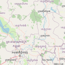
The landscape of Lò Gò–Xa Mát National Park is characterized by semi-plain terrain with relatively flat topography interspersed with low hills, typical of the western edge of Vietnam's Southeast region. Absolute elevations within the park range from 15 to 65 meters above sea level, creating a gentle, undulating terrain that contrasts with the more mountainous areas found further north in the Annamite Range. The most significant hydrological feature is the Vàm Cỏ Đông river, which originates in Cambodia and flows through the park area, forming a 16-kilometer section of the Vietnam-Cambodia border. Several smaller streams drain into the Vàm Cỏ system, including the Đa Hà river in the northeast and the Mẹc Mu, Xa Nghê, Tà Đót, and Bà Diệc streams within the park itself. The park encompasses a mosaic of forest types and wetland habitats, with semi-evergreen forests dominating the upland areas while gallery forests along watercourses and seasonally flooded grasslands occupy the lower-lying zones. The integration of the Chàng Riệc area in 2020 added additional forest coverage to the protected area, extending its ecological footprint across the administrative boundaries of Tân Bình, Tân Lập, Hòa Hiệp, Thạnh Tây, Thạnh Bình, and Thạnh Bắc communes.
Lò Gò, Xa Mát National Park ecosystems, habitats, and plant life
The ecological character of Lò Gò–Xa Mát National Park is defined by a mosaic of tropical forest types and wetland habitats that support significant biodiversity in Vietnam's Southeast region. The forest vegetation includes semi-deciduous forest on lowland areas, evergreen gallery forests along streams and rivers, and Melaleuca forest in wetland zones near the Cambodian border. The dominant tree species include Anisoptera costata, Dipterocarpus alatus, Dipterocarpus costatus, Dipterocarpus intricatus, Hopea odorata, Shorea roxburghii, Xylia xylocarpa, Afzelia xylocarpa, and Pterocarpus macrocarpus, representing the characteristic Dipterocarp assemblages of Southeast Asian lowland forests. The park contains approximately 26 percent of Tây Ninh Province's total natural forest coverage, making it the most significant forest remnant in the province. The seasonally flooded grasslands and wetland areas near the border create distinctive habitat conditions that support specialized flora and provide critical feeding grounds for waterbirds. Several tree species found in the park appear in the Vietnam Red Book, including gõ cà te, giáng hương, and mặc nưa, indicating conservation significance at the national level.
Lò Gò, Xa Mát National Park wildlife and species highlights
The wildlife community of Lò Gò–Xa Mát National Park demonstrates significant biodiversity despite ongoing conservation challenges. Bird diversity is particularly notable, with 177 species confirmed within the park boundaries. The avifauna includes several globally significant species: the endangered Indochinese peacock, the vulnerable Siamese fireback pheasant, and the great hornbill have all been recorded. The park has been recognized as one of Vietnam's Important Bird Areas due to the presence of globally threatened species and restricted-range birds including the Germain's peacock-pheasant and Grey-cheeked fulvetta. The wetland habitats support rare waterbird species including the woolly-necked stork, Java bushfowl, and Asian openbill, while the park serves as a seasonal stopover point for the vulnerable Sarus crane along migration routes between the Mekong Delta and Cambodia. Mammal surveys have confirmed ten species, with conservation-significant species including the black-shanked douc langur, Indochinese silver langur, stump-tailed macaque, Asiatic black bear, dhole, and golden jackal. The presence of the critically endangered Siamese crocodile in the Vàm Cỏ Đông river has been reported through local interviews, though formal surveys have not confirmed its current status. The park's wildlife community remains incompletely surveyed, suggesting potential for additional species discoveries.
Lò Gò, Xa Mát National Park conservation status and protection priorities
Lò Gò–Xa Mát National Park faces significant conservation challenges despite its protected status. The park represents a critical conservation priority as the largest forest area in Tây Ninh Province and a refuge for numerous threatened species, yet management capacity is constrained by limited personnel relative to the large, accessible territory. Primary threats include conversion of wetland habitats for agriculture, illegal logging, hunting and trapping, overharvesting of non-timber forest products, and fire. Hunting and trapping have been identified as the most dangerous threats to biodiversity in the area. The legacy of wartime defoliant use and bombing has left environmental scars that continue to affect ecosystem recovery. A 2001 proposal to drain one of the largest wetlands for resettlement was halted due to the area's high biodiversity value, but pressure for agricultural conversion remains. Conservation programs have included capacity building for park staff, community awareness initiatives, boundary delineation, species and habitat monitoring, and coordination with law enforcement agencies. The park benefits from collaboration with BirdLife International and has been the subject of multiple rapid biodiversity assessments that have informed management priorities.
Lò Gò, Xa Mát National Park cultural meaning and human context
Lò Gò–Xa Mát National Park holds significant cultural and historical importance beyond its ecological value. During the Vietnam War, the area served as a base for the Liberation Radio station of South Vietnam and functioned as a revolutionary headquarters for the People's Liberation Army, giving the region considerable historical significance as a site of anti-colonial resistance activity. The park area also contains the Chàng Riệc Cultural-Historical Forest, which was integrated into the protected area during the 2020 expansion and reflects the region's heritage dimension. The Vàm Cỏ Đông river and surrounding wetlands support local fishing communities who depend on the river's fish resources, creating a traditional livelihood pattern closely tied to the protected area's hydrological systems. The forest also plays an important protective role in flood control for downstream communities along the Vàm Cỏ river system. Approximately 23,500 hectares of buffer zone surrounds the core protected area, within which local communities continue agricultural and resource-gathering activities that create both management challenges and opportunities for collaborative conservation approaches.
Best time to visit Lò Gò, Xa Mát National Park
The optimal time to visit Lò Gò–Xa Mát National Park corresponds with the dry season from November to April, when lower water levels expose湿地 margins and make wildlife viewing more accessible. The period from December to March offers the most comfortable temperatures and reduced precipitation, providing favorable conditions for forest exploration and bird observation. The wet season from May to November brings higher water levels that flood the grassland areas, creating excellent habitat conditions for waterbirds but potentially limiting access to some trail sections. This period also corresponds with the Sarus crane migration, when these large ground birds can be observed in the wetland areas. Visitors interested in birdwatching should note that the dry season facilitates easier observation of forest bird species, while the wet season increases chances of seeing waterfowl and migratory species. The hottest months from March to May coincide with the end of the dry season and may present more challenging conditions for extended field activities.