Mori Atlas logo
National parkMariy Chodra National Park

Discover the mapped terrain and geographic context of Mariy Chodra National Park

Mariy Chodra National Park: Detailed Mapping of Russia's Protected Natural Landscapes

Mariy Chodra National Park represents a significant protected area within the expansive geography of Russia. This page offers a detailed exploration of its mapped boundaries and natural landscape, providing essential context for understanding its place within the national atlas. Explore the terrain and regional setting that define this unique protected territory.

protected areaforest ecosystemRussianature conservationEastern Europe
Stylized illustration of a river flowing through a valley with colorful trees, mountains in the background, and a waterfall cascading down a cliff face.

Mariy Chodra National Park

National park

Park overview

Structured park overview, official facts, and landscape profile for Mariy Chodra National Park

Mariy Chodra National Park park facts, protected area profile, and essential visitor context
Review the core facts for Mariy Chodra National Park, including designation, size, terrain, visitor scale, habitats, and operating context in one park-focused overview.

About Mariy Chodra National Park

Mariy Chodra National Park is a protected area in Russia established to preserve the unique forest ecosystems and natural landscapes of the region. The park derives its name from the Mari people, an ethnic group indigenous to the area, with 'Chodra' referring to forest in the Mari language. This linguistic connection reflects the deep relationship between the local population and the forested landscape that has characterized the region for centuries. The protected area plays a role in maintaining biodiversity and ecological processes within the broader Volga region landscape.

Quick facts and research context for Mariy Chodra National Park

Mariy Chodra National Park is situated in Russia and protects significant forest habitats. The area is recognized as an important ecological zone within the country's system of national parks. The park is associated with the broader Mari Forest ecosystem, which represents a notable forested region in European Russia.

Park context

Deeper park guide and search-rich context for Mariy Chodra National Park

Mariy Chodra National Park history, landscape, wildlife, and travel context
Explore Mariy Chodra National Park through its history, landscape character, ecosystems, wildlife, conservation priorities, cultural context, and seasonal travel timing in a structured park guide built for atlas discovery and search intent.

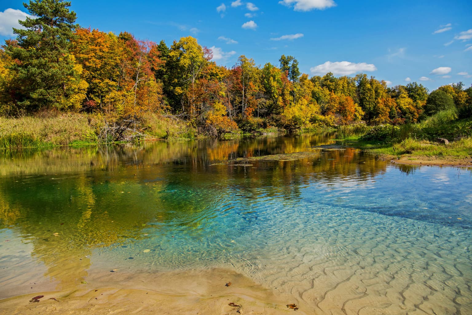
Mariy Chodra National Park cultural meaning and human context

The park's name reflects the cultural heritage of the Mari people, an ethnic minority native to this region of Russia. The Mari language term for forest forms part of the park's name, indicating the historical significance of these woodlands to the local population. This cultural-linguistic connection provides the park with an identity rooted in the traditional relationship between indigenous communities and their forest environment.

Clear river with sandy bottom reflecting autumn trees under blue sky with scattered clouds
Autumn foliage along the Ilet River in Mariy Chodra National Park
Park location guide

Geography guide, regional context, and park location map for Mariy Chodra National Park

Mariy Chodra National Park park geography, regions, and map view in Russia
Understand where Mariy Chodra National Park sits in Russia through a broader geographic reading of the surrounding landscape, nearby location context, and its mapped position within the national park landscape.

How Mariy Chodra National Park fits into Russia

Russia is a transcontinental nation spanning eleven time zones, bordered by fourteen countries. It is the world's largest country by area, covering 17,098,246 km². Moscow is the capital and largest city, while Saint Petersburg is the second-largest and a major cultural centre.

Wider geography shaping Mariy Chodra National Park in Russia

Russia spans Eastern Europe and North Asia, covering 17,098,246 km². It shares land borders with fourteen countries, more than any other nation, and spans eleven time zones. The landscape includes vast plains, mountain ranges such as the Urals and Caucasus, and extensive coastlines along the Arctic Ocean, Pacific Ocean, Baltic Sea, Black Sea, and Caspian Sea.

Map view of Mariy Chodra National Park

Use this park location map to pinpoint Mariy Chodra National Park in Russia, understand its exact geographic position, and read its mapped placement within the surrounding landscape more clearly.

Pigeon | © OpenStreetMap contributors

Visual Journey Through Mariy Chodra's Forest Ecosystems and Russian Conservation Landscapes

Mariy Chodra National Park Photos: Explore Forest Landscapes and Protected Area Scenery
Browse comprehensive imagery of Mariy Chodra National Park to understand its distinctive forest ecosystems and the expansive Russian landscapes it protects. These visual resources offer a clear reference for the park's terrain, habitats, and overall protected-area character, enhancing your geographic exploration.

Clear river with sandy bottom reflecting autumn trees under blue sky with scattered clouds

Park atlas

Trace the geographic context and conservation efforts surrounding Mariy Chodra National Park, with a wider view of Russia's protected lands.

Explore Other National Parks and Protected Areas Near Mariy Chodra National Park
Continue your exploration from Mariy Chodra National Park by mapping other national parks and protected areas across Russia, focusing on similar forest ecosystems and regional distribution. This geographic comparison provides valuable context on conservation landscapes, park diversity, and the spread of protected lands.
Protected area

Chuvash Forest Protected Area: Explore Russian Volga Region's Mixed Woodland Ecosystems

Discover mapped boundaries and regional landscape context.

Chuvash Forest stands as a protected area defined by its mixed woodland ecosystems within Russia's Volga region. This entry provides detailed geographic context, highlighting the park's mapped boundaries and its role as a distinct natural landscape. It serves as an essential point for understanding the environmental character and regional significance of protected lands in Eastern Europe, aiding structured atlas exploration of Russia's natural geography.

IUCN
II
Climate
Temperate
Access
Access unknown
Scope
Terrestrial
Watercolor painting of a river winding through grassy wetlands with distant hills under a pastel sky
National parkRepublic of Mordovia

Smolny National Park: National Park Protected Area and Geographic Context in Republic of Mordovia

Explore the mapped landscape and regional geography of Smolny National Park.

Delve into the specifics of Smolny National Park, a designated national park in Russia's Republic of Mordovia. This detailed atlas view focuses on its protected area identity and geographic setting, providing essential context for understanding its landscape. Discover the mapped boundaries and regional placement that define this protected territory, crucial for any structured exploration of Russian natural areas.

Area
365 km²
Established
1995
IUCN
II
Relief
Lowland
Watercolor painting of a meadow with wildflowers and rolling hills under a soft sky
National park

Sengileevskie Mountains National Park: National Park Protected Area and Mapped Landscape Context

Explore protected boundaries and regional geography.

Uncover the geographic specifics of Sengileevskie Mountains National Park, a designated national park. This entry provides detailed insights into its protected area status, mapped landscape features, and regional context, serving as a foundational element for atlas-based exploration and understanding of Russia's conservation areas.

IUCN
II
Watercolor illustration showing a river flowing through a valley with trees and distant mountains
National parkTatarstan

Nizhnyaya Kama National Park: Protected Area and Geographic Context in Tatarstan

Discover mapped boundaries and regional landscape insights.

Nizhnyaya Kama National Park serves as a distinct protected area within the republic of Tatarstan, Russia. This detail page provides essential geographic context and map-oriented information, focusing on the park's boundaries and its contribution to the regional landscape. It is designed for users seeking structured data on protected lands, offering a factual entry point for understanding this Russian national park within a broader atlas framework.

Area
265.87 km²
Established
1991
IUCN
II
Relief
Lowland
Watercolor illustration of a river flowing through a valley with green hills and scattered trees in the background
National parkSamara Oblast

Samarskaya Luka National Park: National Park Geographic Discovery in Samara Oblast

Explore mapped protected landscapes and regional terrain.

Samarskaya Luka National Park offers a focused lens for exploring protected natural areas, specifically detailing the geography and mapped boundaries of this Russian national park. Users can leverage this atlas-centric entry point to understand the park's landscape context within Samara Oblast. MoriAtlas provides a structured approach to discovering such protected lands, emphasizing their placement within regional geography and offering a rich foundation for mapped terrain exploration.

Area
1,340 km²
Established
1984
IUCN
II
Relief
Mixed relief
Watercolor illustration of a winding river through a valley with rolling hills and sparse vegetation under a soft sky
National parkUdmurt Republic

Nechkinsky National Park: Protected River Valley Landscape and Archaeological Heritage

Explore Udmurt Republic's National Park Geography and Terrain

Nechkinsky National Park, situated in the Udmurt Republic, is a vital protected area distinguished by its prominent river valley landscape. The park's geography features a stark contrast between steep right-bank slopes and a wide, flat left-bank floodplain, bordered by the Votkinsk reservoir. This unique terrain supports diverse ecosystems and preserves thousands of years of archaeological heritage, making it a focal point for understanding the region's natural and cultural map.

Area
208 km²
Established
1997
IUCN
II
Relief
Mixed relief
Watercolor illustration of green hills, a body of water, and pink and yellow vegetation
National parkSaratov Oblast

Khvalynsky National Park: Protected Landscape and Regional Geography Atlas

Discover mapped park boundaries in Saratov Oblast

Khvalynsky National Park is a significant protected area designated as a national park within the Saratov Oblast. This entry provides detailed atlas-based insights into its geographic scope, protected landscape features, and its context within the wider regional geography of Southeastern European Russia. Explore the mapped terrain and understand how this park contributes to the conservation landscape of the Volga region.

Area
255 km²
Established
1994
IUCN
II
Visitors
35K annual
National parkKomi Republic

Koygorodsky National Park: Protected Landscape Exploration and Regional Geography

Mapped boundaries and natural landscape context.

Gain a structured understanding of Koygorodsky National Park, a designated national park within the Komi Republic. This entry facilitates exploration of its protected landscape, mapped geographic features, and its role within the broader regional atlas. Focus on the park's identity as a distinct protected area and its contribution to understanding Russian natural geography through detailed, map-centric data.

Area
567 km²
Established
2019
IUCN
II
Relief
Lowland

Common questions about visiting, size, designation, and location context for Mariy Chodra National Park

Mariy Chodra National Park FAQs for park facts, access, geography, and protected area context
Find quick answers about Mariy Chodra National Park, including protected-area facts, park geography, trail and visitor context, and how the park fits into its surrounding country and regional landscape.
MoriAtlas Explorer

Continue Your Protected Areas Search Across the Global Atlas

Deepen your exploration by continuing the structured search for national parks and protected areas worldwide. Utilize the comprehensive filtering capabilities to compare different conservation landscapes and refine your understanding of global park geography. Discover more about the distribution and characteristics of protected natural areas.

Global natural geography