Mori Atlas logo
National parkKoygorodsky National Park

Uncover the geographic context and mapped boundaries of this key protected area.

Koygorodsky National Park: A Protected Natural Landscape in Russia's Komi Republic

(National Park Koygorodsky)

Koygorodsky National Park represents a significant protected landscape within the Komi Republic, offering a valuable entry point for geographic discovery. This page details the park's identity as a national park, providing insights into its mapped boundaries and its place within the regional geography. Explore the structured data that defines Koygorodsky National Park for atlas-based navigation and a deeper understanding of protected natural areas in Russia.

TaigaOld-growth forestProtected forestBoreal ecosystemNature reserveNorthern Russia

Koygorodsky National Park

National park

Park overview

Structured park overview, official facts, and landscape profile for Koygorodsky National Park

Koygorodsky National Park park facts, protected area profile, and essential visitor context
Review the core facts for Koygorodsky National Park, including designation, size, terrain, visitor scale, habitats, and operating context in one park-focused overview.

About Koygorodsky National Park

Koygorodsky National Park represents a significant addition to Russia’s protected area network, established in 2019 to preserve one of the continent’s last great tracts of untouched southern taiga forest. The park is situated on the eastern margin of the East European Plain, in the southern reaches of the Komi Republic, a vast republic in northwestern Russia known for its extensive boreal forests. The protected area spans the administrative territories of both Koygorodsky District and Priluzsky District, forming a contiguous protected zone together with the adjacent Nurgush-Tulashor nature reserve. The park’s establishment reflects growing recognition of the ecological importance of old-growth forest ecosystems in Europe, where such pristine landscapes have become increasingly rare due to centuries of forestry, agriculture, and industrial development. By 2021, scientific teams were actively working to document the park’s biological diversity, recognizing that the full extent of flora and fauna species present in this relatively new protected area was still being discovered.

Quick facts and research context for Koygorodsky National Park

Koygorodsky National Park covers 56,700 hectares in the Komi Republic of Russia, established in 2019. The park protects one of the largest remaining tracts of virgin southern taiga in Europe, with over 99 percent forest cover and virtually no human settlements or road infrastructure. The terrain is exceptionally flat, with elevation changes of only 50 meters across the entire protected area. The park sits at the boundary between rivers flowing north to the White Sea and those flowing south toward the Caspian Sea. The surrounding region experiences a subarctic climate with brief, mild summers and cold, snowy winters.

Park context

Deeper park guide and search-rich context for Koygorodsky National Park

Koygorodsky National Park history, landscape, wildlife, and travel context
Explore Koygorodsky National Park through its history, landscape character, ecosystems, wildlife, conservation priorities, cultural context, and seasonal travel timing in a structured park guide built for atlas discovery and search intent.

Why Koygorodsky National Park stands out

The park is most notable for its extensive old-growth fern-green spruce forests, a rare taiga type that persists only where logging and human disturbance have been absent for extended periods. These mature spruce-dominated forests, combined with significant old-growth aspen stands, represent some of the most pristine forest ecosystems remaining in the European taiga belt. The park also stands out for its remarkably low human footprint, with no settlements within its boundaries and roads covering only about one percent of the total area.

Koygorodsky National Park history and protected-area timeline

Koygorodsky National Park was officially established on July 12, 2019, making it one of Russia’s more recently designated national parks. The creation of the park represented a culmination of conservation efforts to protect the remaining virgin forest landscapes in the southern portion of the Komi Republic. Prior to designation, the area had remained largely undeveloped due to its remote location and challenging terrain, allowing forests to mature without significant industrial intervention. The park is managed by FGBU Koygorodsky, the federal government body responsible for overseeing its protection and sustainable management. Since its establishment, the park has been the focus of systematic scientific inventory efforts to document its ecological resources and establish a baseline for ongoing conservation work.

Koygorodsky National Park landscape and geographic character

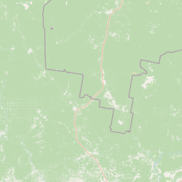
The terrain within Koygorodsky National Park is remarkably flat, with the highest and lowest points differing by only 50 meters in elevation. This low-relief landscape is characterized by extensive floodplains formed by meandering rivers that wind slowly across the forest floor. The hydrological character of the area is defined by a positive water balance, where annual precipitation exceeds evapotranspiration, resulting in abundant surface water that collects in a network of rivers, streams, and lakes. The Sedka River flows northward from the park, ultimately reaching the White Sea, while other smaller watercourses flow southward into rivers that drain toward the Caspian Sea. This watershed divide adds geographic significance to the park’s location. The flat, poorly-drained terrain supports the extensive wetland and forest ecosystems that define the park’s character.

Koygorodsky National Park ecosystems, habitats, and plant life

The park is situated within the Scandinavian and Russian taiga ecoregion, one of the world’s largest contiguous forest ecosystems. The climate is classified as subarctic (Dfc under the Köppen system), featuring short, mild summers with only one to three months exceeding 10 degrees Celsius, and long, cold winters with the coldest month averaging below minus 3 degrees Celsius. Snow cover persists through the winter season, creating the conditions typical of boreal forest environments. The park is characterized by exceptional forest cover exceeding 99 percent, with the landscape remaining entirely undeveloped and free from fragmentation. This makes the protected area one of the most ecologically intact forest landscapes in the European portion of the taiga zone.

Koygorodsky National Park wildlife and species highlights

Koygorodsky National Park supports notable biodiversity, particularly in its old-growth forest habitats. Avian surveys have documented 118 bird species within the park, including 14 species that are classified as critically endangered, vulnerable, or near-threatened on conservation Red Lists. The Yellow-breasted bunting and the Greater spotted eagle represent two particularly significant species found in the park, both facing population pressures across their ranges. Mammal species of conservation interest include the near-threatened Eurasian otter, a semi-aquatic predator dependent on clean water bodies and riparian habitats, and the Pond bat, a species of bat that inhabits wetland areas. The park also provides habitat for the Siberian salamander, a common amphibian species in the region’s wet forest environments.

Koygorodsky National Park conservation status and protection priorities

The establishment of Koygorodsky National Park reflects the growing recognition that old-growth taiga forests represent irreplaceable ecological assets requiring active protection. The park preserves rare fern-green spruce forests that can only develop where human disturbance has been absent for extended periods, making them among the most ecologically valuable and threatened forest types in Europe. The park’s proximity to the Nurgush-Tulashor nature reserve creates a larger contiguous protected zone that supports ecological connectivity and allows wildlife populations to maintain natural movement patterns. With virtually no settlements and roads covering only about one percent of the area, the park maintains an exceptionally low human footprint that supports natural ecological processes and preserves the integrity of the forest ecosystem.

Koygorodsky National Park cultural meaning and human context

The park is located in the Komi Republic, a region historically associated with the Komi people, an indigenous Finno-Ugric population whose traditional territories span the boreal forests of northeastern European Russia. While the park itself contains no settlements, the broader region has a long history of human presence tied to forestry, reindeer husbandry, and traditional resource use. The establishment of the park represents a balance between continued recognition of the region’s cultural heritage and the ecological imperative to preserve the remaining tracts of virgin forest that have survived largely intact.

Top sights and standout views in Koygorodsky National Park

The park protects one of Europe’s largest remaining expanses of virgin southern taiga, featuring old-growth spruce forests and old-growth aspen stands that represent rare ecological communities. The absence of roads, settlements, and significant human infrastructure makes this one of the most ecologically intact forest protected areas in the region. The park sits at a continental watershed divide, with rivers flowing to both the White Sea and the Caspian Sea. Bird diversity includes significant populations of conservation-concern species, while the overall landscape represents a near-pristine example of boreal forest ecology.

Best time to visit Koygorodsky National Park

The optimal visiting period for Koygorodsky National Park corresponds to the brief summer season typical of subarctic climates. The summer months, when temperatures rise above 10 degrees Celsius, offer the most accessible conditions for exploration and wildlife observation. Winter visits are possible but present significant challenges due to extreme cold and heavy snow cover. Spring and autumn serve as transitional seasons that offer unique opportunities to observe seasonal phenomena such as bird migrations and the changing character of the forest.

Park location guide

Geography guide, regional context, and park location map for Koygorodsky National Park

Koygorodsky National Park park geography, regions, and map view in Russia
Understand where Koygorodsky National Park sits in Russia through a broader geographic reading of the surrounding landscape, nearby location context, and its mapped position within the national park landscape.

How Koygorodsky National Park fits into Russia

Russia is a transcontinental nation spanning eleven time zones, bordered by fourteen countries. It is the world's largest country by area, covering 17,098,246 km². Moscow is the capital and largest city, while Saint Petersburg is the second-largest and a major cultural centre.

Wider geography shaping Koygorodsky National Park in Russia

Russia spans Eastern Europe and North Asia, covering 17,098,246 km². It shares land borders with fourteen countries, more than any other nation, and spans eleven time zones. The landscape includes vast plains, mountain ranges such as the Urals and Caucasus, and extensive coastlines along the Arctic Ocean, Pacific Ocean, Baltic Sea, Black Sea, and Caspian Sea.

Map view of Koygorodsky National Park

Use this park location map to pinpoint Koygorodsky National Park in Russia, understand its exact geographic position, and read its mapped placement within the surrounding landscape more clearly.

Pigeon | © OpenStreetMap contributors

Location context for Koygorodsky National Park

Komi Republic
Park atlas

Continue Your Park Discovery Journey from Koygorodsky, Tracing Russia's Pristine Taiga Belt and Connected Forest Reserves

Explore Other Protected Areas and National Parks Near Koygorodsky National Park
Explore a curated list of national parks and protected areas geographically related to Koygorodsky National Park, covering expansive old-growth taiga forests and unique boreal ecosystems across the Komi Republic region. Users can compare distinct protected landscapes, trace watershed divides, and understand the regional spread of conservation efforts, moving from one park to others.
National parkUdmurt Republic

Nechkinsky National Park: Protected River Valley Landscape and Archaeological Heritage

Explore Udmurt Republic's National Park Geography and Terrain

Nechkinsky National Park, situated in the Udmurt Republic, is a vital protected area distinguished by its prominent river valley landscape. The park's geography features a stark contrast between steep right-bank slopes and a wide, flat left-bank floodplain, bordered by the Votkinsk reservoir. This unique terrain supports diverse ecosystems and preserves thousands of years of archaeological heritage, making it a focal point for understanding the region's natural and cultural map.

Area
208 km²
Established
1997
IUCN
II
National parkTatarstan

Nizhnyaya Kama National Park: Protected Area and Geographic Context in Tatarstan

Discover mapped boundaries and regional landscape insights.

Nizhnyaya Kama National Park serves as a distinct protected area within the republic of Tatarstan, Russia. This detail page provides essential geographic context and map-oriented information, focusing on the park's boundaries and its contribution to the regional landscape. It is designed for users seeking structured data on protected lands, offering a factual entry point for understanding this Russian national park within a broader atlas framework.

Area
265.87 km²
Established
1991
IUCN
II
Relief
Lowland
National parkKomi Republic

Yugyd Va National Park: Protected Taiga Wilderness & Ural Mountain Landscape

Explore Europe's largest national park within the Komi Republic.

Yugyd Va National Park is a premier protected area, recognized as Europe's largest national park and a critical component of the Virgin Komi Forests World Heritage Site. This vast wilderness in Russia's Komi Republic showcases a diverse geographic tapestry, from the highest peaks of the Ural Mountains to extensive boreal forests and alpine tundra. MoriAtlas provides detailed mapping and geographic context for understanding the park's unique landscape, its position on the Europe-Asia boundary, and its significance as a protected subarctic ecosystem.

Area
18,917 km²
Established
1994
Visitors
4K annual
Relief
Mountain
National parkRepublic of Mordovia

Smolny National Park: National Park Protected Area and Geographic Context in Republic of Mordovia

Explore the mapped landscape and regional geography of Smolny National Park.

Delve into the specifics of Smolny National Park, a designated national park in Russia's Republic of Mordovia. This detailed atlas view focuses on its protected area identity and geographic setting, providing essential context for understanding its landscape. Discover the mapped boundaries and regional placement that define this protected territory, crucial for any structured exploration of Russian natural areas.

Area
365 km²
Established
1995
IUCN
II
Relief
Lowland
Watercolor illustration of a landscape with trees, hills, and water
National parkVologda Oblast

Russky Sever National Park: National Park Protected Landscape and Regional Geography

Explore mapped boundaries and natural terrain context.

Delve into the specifics of Russky Sever National Park, a key protected area situated in the Vologda Oblast region of Northwestern Russia. This page serves as a geographic anchor, detailing the park's protected landscape and its mapped presence within the regional atlas. Understand the natural terrain and boundaries that define this significant national park, providing a focused perspective for atlas-based exploration and geographic discovery.

Area
1,664 km²
Established
1992
IUCN
II
Relief
Highland
National park

Kenozersky National Park: Northern Russia's Protected Glacial Landscape and Historic Architecture

Explore mapped terrain, lake systems, and cultural geography.

Kenozersky National Park is a significant protected area in Arkhangelsk Oblast, Russia, notable for its preservation of a distinctive northern landscape. Defined by glacial topography, the park features rolling hills, numerous lakes and wetlands, and extensive boreal forests. Beyond its natural geography, Kenozersky National Park also safeguards a rich cultural heritage, particularly the surviving historic wooden churches and chapels that are integral to its identity. This national park offers a unique opportunity for structured discovery of protected lands and their associated regional context.

National parkYaroslavl Oblast

Pleshcheyevo Ozero National Park: National Park Mapping and Regional Protected Area Atlas

Discover its protected landscape and geographic setting.

Pleshcheyevo Ozero National Park is a key protected area within the geography of Yaroslavl Oblast, Russia. This page offers detailed insights into the park's specific landscape character, its mapped boundaries, and its significance as a national park. It serves as an entry point for understanding the protected lands of the region and exploring its natural terrain within a broader atlas context.

Area
238 km²
Established
1997
IUCN
II
Relief
Lowland
Watercolor painting of a lake surrounded by trees and distant hills
National parkVladimir Oblast

Meshchyora National Park: A Premier Wetland Protected Area in Vladimir Oblast

Explore its mapped boundaries and intricate floodplain geography.

Meshchyora National Park is a key protected landscape in central Russia, renowned for its expansive wetland ecosystems across the Meshchera Lowlands of Vladimir Oblast. Covering nearly 119,000 hectares, the park preserves a unique glacial terrain of peatlands, lakes, and meandering rivers, supporting remarkable biodiversity. Its role as a vital component of the Oka River basin and its conservation focus on restoring degraded peatlands make it a significant site for atlas-based geographic discovery and understanding protected area landscapes.

Area
1,189 km²
Established
1992
IUCN
II
Relief
Lowland

Common questions about visiting, size, designation, and location context for Koygorodsky National Park

Koygorodsky National Park FAQs for park facts, access, geography, and protected area context
Find quick answers about Koygorodsky National Park, including protected-area facts, park geography, trail and visitor context, and how the park fits into its surrounding country and regional landscape.
MoriAtlas Explorer

Continue Your Protected Areas Search Across the Global Atlas

Deepen your exploration by continuing the structured search for national parks and protected areas worldwide. Utilize the comprehensive filtering capabilities to compare different conservation landscapes and refine your understanding of global park geography. Discover more about the distribution and characteristics of protected natural areas.

Global natural geography