Why Mgahinga Gorilla National Park stands out
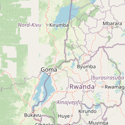
Mgahinga is renowned as one of the most important mountain gorilla habitats in East Africa. The park protects approximately 30 mountain gorillas distributed across one habituated group available for trekking and two unhabituated groups. The park is also the stronghold for the golden monkey, an Albertine Rift endemic whose global range is now restricted to the Virunga volcanoes and a single forest in Rwanda. The three volcanic peaks offer rare opportunities for high-altitude hiking within Uganda, with Mount Muhabura providing particularly striking views of the surrounding landscape.
Mgahinga Gorilla National Park history and protected-area timeline
Mgahinga Gorilla National Park was formally established in 1991, though the area had previously existed as a game reserve from the 1930s until 1950. During this earlier period, portions of what is now the park were converted to agricultural use at lower altitudes. Conservation efforts reintensified in 1989 with the initiation of biological surveys, the removal of wire traps, the training of rangers, and the implementation of reforestation programs. Settlers were relocated from within the park boundaries during the early 1990s to consolidate the protected area. A significant historical event occurred in November 2013 when the M23 Movement, a Congolese rebel group, surrendered in the park after being defeated by the Congolese army during the M23 rebellion, marking an unusual moment when the park became associated with regional political events.
Mgahinga Gorilla National Park landscape and geographic character
The landscape of Mgahinga Gorilla National Park is dominated by three extinct volcanic peaks that form part of the Virunga Mountains chain. Mount Muhabura rises to 4,127 meters as the highest peak within the park, followed by Mount Gahinga and Mount Sabyinyo. The terrain is characterized by steep volcanic slopes, rocky ridges, and the distinctive profiles of these ancient volcanoes. The altitudinal range from 2,227 meters at the lowest points to 4,127 meters at Muhabura's summit creates a dramatic transition through distinct ecological zones. The park sits within the Nile River watershed, with streams and drainage patterns flowing outward from these highland areas to eventually join the larger river system.
Mgahinga Gorilla National Park ecosystems, habitats, and plant life
The park encompasses an exceptional range of habitats that reflect its dramatic altitudinal gradient. At lower elevations, dense bamboo forest dominates, creating one of the most extensive bamboo forest areas in the Virunga region. This transitions into Albertine Rift montane forests characterized by moist, species-rich woodland. At higher altitudes, the forest gives way to Ruwenzori-Virunga montane moorlands featuring the distinctive tree heath, a gnarled and wind-shaped vegetation adapted to the harsh alpine conditions. The alpine zone at the highest elevations supports sparse vegetation adapted to the cool, windy conditions above the tree line. This vertical sequence of habitats makes Mgahinga a remarkable example of tropical mountain ecosystem diversity within a relatively small area.
Mgahinga Gorilla National Park wildlife and species highlights
Mgahinga Gorilla National Park supports remarkable primate diversity, with the mountain gorilla as the flagship species. Approximately 30 individuals occupy the park, divided between one habituated group available for gorilla trekking tourism and two unhabituated groups. The golden monkey, an Albertine Rift endemic, represents another critically important species whose current global distribution is limited almost exclusively to the Virunga volcanoes. The park's mammal checklist includes 76 species, among them black-and-white colobus, leopard, African bush elephant, giant forest hog, bushpig, buffalo, Cape bushbuck, and black-fronted duiker. The avifauna is particularly notable for its Albertine Rift endemics, with surveys documenting species including handsome spurfowl, dusky crimson-wing, red-throated alethe, Kivu ground thrush, Rwenzori turaco, Rwenzori batis, and the Rwenzori double-collared sunbird.
Mgahinga Gorilla National Park conservation status and protection priorities
Mgahinga Gorilla National Park plays a vital role in the conservation of some of Africa's most endangered species and most threatened ecosystems. As part of the Virunga transboundary landscape, the park contributes to a contiguous protected area network spanning three countries, essential for species that require large home ranges like the mountain gorilla. The park protects critical habitat for the mountain gorilla, whose global population numbers only around 1,000 individuals, making every protected population significant for species survival. The golden monkey, restricted to the Virungas and one additional forest in Rwanda, benefits from the park's protection of its remaining habitat. The Albertine Rift is recognized as a biodiversity hotspot, and Mgahinga's protection of montane forest and alpine moorland habitats contributes to preserving this region's exceptional endemic species.
Mgahinga Gorilla National Park cultural meaning and human context
The region surrounding Mgahinga Gorilla National Park is home to the Batwa people, a community traditionally associated with the forests of the Virunga region. The Batwa, often referred to as Pygmies, have historically relied on the forest for their livelihoods, including hunting and gathering. While the establishment of the park changed traditional land use patterns, the Batwa community remains connected to the landscape. Local communities in Kisoro District maintain agricultural practices in the surrounding highlands, with terraced cultivation visible on the hillsides approaching the park boundaries.
Top sights and standout views in Mgahinga Gorilla National Park
Mgahinga Gorilla National Park offers a combination of wildlife experiences and mountaineering opportunities found in few other Ugandan protected areas. Gorilla trekking provides access to habituated mountain gorilla groups in a relatively compact park setting, while golden monkey encounters offer additional primate viewing. The three volcanic peaks present hiking opportunities for those seeking physical challenge and panoramic views, with Mount Muhabura offering particularly commanding perspectives of the surrounding Virunga landscape. The park's position at the intersection of three countries creates a distinctive geographical setting, while the vertical habitat gradient from bamboo forest through montane forest to alpine moorland provides ecological variety within a small area.
Best time to visit Mgahinga Gorilla National Park
The park experiences two wet seasons, with the primary rains falling from February to May and a secondary wet period from September to December. October typically sees the highest rainfall at around 250 millimeters, while July is the driest month with approximately 10 millimeters. The drier conditions from June through August and January through February generally offer more comfortable conditions for trekking and hiking, though the park can be visited year-round. The dry seasons typically provide clearer views and easier trail conditions, while the wet seasons bring lush green vegetation though with more challenging travel conditions.