
Viewpoints
Park geography
Detailed spatial data covering natural features, environmental landscape, and terrain
Mokala National Park Geographic Profile and Mapped Boundaries in the Northern Cape Region
Examine the technical geographic specifications of Mokala National Park, a protected area spanning 196.11 square kilometers within South Africa. This profile catalogs the park boundary, mixed terrain relief, and physical associations including the Riet River and Rhino toilet. Understand the regional context through arid climate zones, diverse habitat types, and distinct landscape features ranging from grassland to karst.
Related tags
Semi-desert reserveKalahari ecosystemNama KarooEndangered species protectionRhino conservation
Arid Kalahari sanctuary protecting endangered wildlife in South Africa's Northern Cape
Mokala National Park
Mokala National Park is a relatively young South African national park established in the arid Northern Cape region, southwest of Kimberley. The park covers approximately 196 square kilometres of transition landscape where the Kalahari savanna meets the Nama Karoo biome. Its name, Mokala, is derived from the Setswana language and refers to the magnificent camel thorn tree (Acacia erioloba), a species that dominates the sandy Kalahari portions of the reserve. The park was created in 2007 as a replacement for the deproclaimed Vaalbos National Park and represents SANParks' commitment to maintaining protected areas in the region despite land claims and mineral rights challenges. The park serves as a critical refuge for endangered species including Cape buffalo, black rhino, white rhino, and roan antelope.
- Location
- South Africa
- Park type
- National park
- Established
- 2007
- Area
- 196.1 km²
Location overview
Provincial placement and administrative location within South Africa
Geographic Location and Regional Profile of Mokala National Park
Mokala National Park is situated within the Northern Cape region of South Africa. The interior reserve profile outlines recorded administrative boundaries and regional placement within the national conservation framework.
- Countries
- South Africa
- Regions
- Northern Cape
- Primary location
- Northern Cape
- Geographic setting
- Inland
Boundary and coordinates
Mapped protected perimeter and spatial measurements
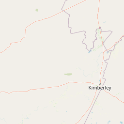
Mokala National Park Boundary Map and Geographic Extent
Interactive boundary geometry establishes the spatial context for protected land coverage. Derived area measurements and coordinate limits outline the geographical extent of the protected reserve.
- Boundary area
- 285.6 km²
- Boundary perimeter
- 121.7 km
- Northernmost point
- 28.9974° S
- Southernmost point
- 29.2263° S
- Easternmost point
- 24.5134° E
- Westernmost point
- 24.2231° E
- Geographic centre
- 29.1123° S, 24.3605° E
- North–south span
- 25.4 km
- East–west span
- 28.3 km
Terrain and natural features
Mixed terrain classifications and interior water features
Mokala National Park Terrain Geography and Named Natural Features
Mixed relief classifications define the protected landscape alongside recorded geographic features located directly within the boundary. Structured feature cards present names, types, measurements, and spatial relationships for each entry.
Selected named natural features
Rivers
Riet River
Environmental setting
Arid climate zones, mixed relief, and seasonal water classifications
Mokala National Park Environmental Settings and Landscape Classifications
Recorded classifications frame the physical setting across varied habitat types and partial forest cover. Categories link directly to relevant atlas destinations matching each environmental feature.
- Relief
- Mixed relief
- Climate
- Arid
- Water
- Major water bodies
- Forest cover
- Partial forest
- Seasonality
- Seasonal
Landscape features
Forest · Woodland · Grassland · Steppe · Hills · Cliffs · Karst · Lakes · Rivers
Habitat types
Savanna · Grassland · Shrubland · Karst habitat · Desert habitat
Park atlas
Trace the regional spread of protected landscapes complementing Mokala National Park's unique Kalahari-Karoo transition.
Explore Nearby National Parks and Protected Areas Around Mokala National Park's Biomes
Expand your geographic discovery from Mokala National Park, browsing other national parks and protected areas across the Northern Cape's arid Kalahari savanna and Nama Karoo landscapes. Compare their distinct biomes, conservation landscapes, and mapped terrain to deepen your understanding of regional protected area geography.
Nature reserveNorthern Cape
About 181 km away#1 closest
West

Witsand Nature Reserve: Protected Sand Dunes and Northern Cape Regional Geography
A remote arid plateau and singing sand landscape
Witsand Nature Reserve encompasses a 3,500 hectare protected area set atop a rocky plateau in the Northern Cape. Known for its distinctive red Kalahari-style dunes that produce acoustic booming sounds, the reserve offers a unique look at the arid interior of South Africa through a lens of quiet, expansive geography and remote terrain.
- Area
- 31.7 km²
- Established
- 1994
- Relief
- Upland
- Climate
- Arid
Nature reserveNorth West
About 182 km away#2 closest
Northeast
S.A. Lombard Nature Reserve: Mapping Protected Grasslands in North West South Africa
A critical study of semi-arid veld and grassland conservation zones
Situated on the arid North West plains, S.A. Lombard Nature Reserve occupies a distinct geographic role as a protected enclave. The site features a flat, treeless interior plateau characterized by the transition between brackish turf and sandy veld, serving as a vital sanctuary for historically vulnerable antelope populations.
- Area
- 46 km²
- Established
- 1954
- Relief
- Lowland
- Scope
- Terrestrial
Natural monumentMaseru District
About 309 km away#3 closest
East

Thaba Bosiu Natural Monument: Mapping the Plateau Geography in Maseru District
A fortified sandstone landscape with deep cultural roots
Thaba Bosiu remains one of the most recognizable geographic landmarks in Lesotho, featuring a flat-topped sandstone summit surrounded by sheer cliffs. This natural monument provides a unique window into the regional terrain, tracing the intersection of river valley systems, basalt formations, and historical mountain refuge sites that define the Maseru District.
- Area
- 2 km²
- Established
- 1967
- Relief
- Mountain
- Access
- Easy access
National parkNorthern Cape
About 320 km away#4 closest
Southwest
Meerkat National Park National Park: Geographic Atlas and Protected Landscape Details
Explore the mapped boundaries and regional geography of Meerkat National Park.
Meerkat National Park is a significant protected area identified as a national park within the expansive Northern Cape region of South Africa. This detail page offers insight into its specific landscape character and mapped geographic extent, serving as a crucial node for atlas-based exploration. Understand the park's role as a protected national landscape and its relationship to the broader regional geography of Northern Cape, contributing to a structured understanding of conservation areas.
- Area
- 1,352.45 km²
- Established
- 2020
- IUCN
- II
- Relief
- Lowland
National parkEastern Cape
327 km away#5 closest
South
Camdeboo National Park: Protected Landscape Atlas and Eastern Cape Geographic Context
Discover the mapped geography and protected area identity of this Eastern Cape national park.
Camdeboo National Park represents a key protected landscape within the Eastern Cape province of South Africa. This entry provides essential details for understanding its protected-area status, geographic footprint, and its role within the regional atlas. Examine its mapped boundaries and explore the unique natural terrain it encompasses, gaining specific insight into its protected landscape characteristics.
- Area
- 194.05 km²
- Established
- 2005
- Relief
- Mountain
- Climate
- Arid
National parkEastern Cape
327 km away#6 closest
South
Mountain Zebra National Park: A National Park within Eastern Cape's Geography
Explore its mapped protected boundaries and regional landscape context.
Mountain Zebra National Park serves as a key protected area within South Africa's Eastern Cape region. This page offers an atlas-driven perspective, detailing the park's geographic scope and mapped boundaries. Understand its role as a national park and its contribution to the regional landscape context, providing structured data for those interested in protected land distribution and natural terrain.
- Area
- 284 km²
- Established
- 1937
- IUCN
- II
- Visitors
- 31.2K annual
National parkEastern Cape
329 km away#7 closest
Southeast
Grassland National Park National Park: Exploring Protected Landscapes and Regional Geography
Mapped boundaries and natural terrain context for an Eastern Cape protected area.
Grassland National Park represents a crucial protected area within South Africa's Eastern Cape province. As a national park, it offers significant insights into the region's natural landscapes and geographic character. This atlas perspective focuses on understanding the park's mapped scope, its terrain features, and its place within the broader provincial geography. Discover the unique protected landscape identity of Grassland National Park and how it contributes to the mapped natural heritage of the Eastern Cape.
- Area
- 102.25 km²
- Established
- 2025
- IUCN
- II
- Relief
- Mountain
Wildlife reserveWestern Cape
369 km away#8 closest
Southwest
Karoo National Park Wildlife Reserve: Mapped Boundaries and Geographic Context
Explore the protected landscape of this Western Cape wildlife reserve.
Karoo National Park stands as a protected wildlife reserve, offering insights into the natural geography of South Africa's Western Cape. This detail page provides an atlas view of its protected landscape, mapping its boundaries and situating it within its regional context. Engage with the park's identity as a conservation area and understand its geographic significance for dedicated exploration.
- Area
- 767.9 km²
- Established
- 1979
- Relief
- Mountain
- Climate
- Arid
MoriAtlas Explorer
Continue Your Atlas Exploration of Mokala National Park's Geography
Delve deeper into the geographic context and mapped features of Mokala National Park. Understanding this protected landscape within the Northern Cape offers valuable insights for regional geography and atlas exploration. Continue to uncover the structured details of this national park and its surrounding natural terrain.
Browse next
Global natural geography
Explore related park routes
Explore MoriAtlas Global ParksBrowse All MoriAtlas ParksGlobal Park Map DiscoveryMoriAtlas: Browse All CountriesBrowse All MoriAtlas ContinentsNational Park Environment AtlasGrand Canyon National Park AtlasYellowstone National Park AtlasYosemite National Park Atlas and GeographySerengeti National Park AtlasGalápagos National Park Protected LandscapeBanff National Park Geography and AtlasKruger National Park Atlas EntryUluṟu-Kata Tjuṯa National Park AtlasExplore Uluru-Kata Tjuta National Park GeographyPlitvice Lakes National Park AtlasFiordland National Park Protected LandscapeGreat Smoky Mountains National Park AtlasAfghanistan National Parks and Protected AreasAlbania National Parks and Protected AreasAlgeria National Parks and Protected AreasAmerican Samoa National Parks and Protected AreasAndorra National Parks and Protected AreasAngola National Parks and Protected AreasAntarctica National Parks and Protected AreasAntigua and Barbuda Park List