Mori Atlas logo
Nature reserveMont Grand Matoury Nature Reserve

Discover the mapped boundaries and natural terrain of this vital nature reserve.

Mont Grand Matoury Nature Reserve: Protected Landscape and Geographic Context in French Guiana

(Réserve naturelle nationale du mont Grand Matoury)

Mont Grand Matoury Nature Reserve represents a significant protected landscape situated within the expansive rainforests of French Guiana. As a dedicated nature reserve, its geographic identity is closely tied to the unique terrain and tropical environment of South America's Guianas region. This page offers an atlas-driven perspective, allowing for detailed exploration of the reserve's mapped boundaries, its place within the regional geography, and the structured factual context crucial for understanding its conservation significance.

Tropical RainforestGranite MountainBiodiversity HotspotCoastal WetlandsBirdwatchingButterfly Diversity

Mont Grand Matoury Nature Reserve

Nature reserve

Park overview

Structured park overview, official facts, and landscape profile for Mont Grand Matoury Nature Reserve

Mont Grand Matoury Nature Reserve park facts, protected area profile, and essential visitor context
Review the core facts for Mont Grand Matoury Nature Reserve, including designation, size, terrain, visitor scale, habitats, and operating context in one park-focused overview.

About Mont Grand Matoury Nature Reserve

Mont Grand Matoury Nature Reserve represents a distinctive protected area in French Guiana, combining a dramatic physical landmark with remarkable ecological diversity. The reserve takes its name from Mont Grand Matoury, a granite inselberg that rises abruptly from the surrounding landscape to a height of 234 metres. This mountain, despite its modest elevation, serves as a biological island of forest in a region otherwise characterized by coastal wetlands and savannahs. The reserve's ecological significance stems from its position at the boundary between two major habitat types: the mangrove forests and coastal lowlands of the Guianan coast, and the inland old-growth forests that cover the higher ground. This transitional character creates a mosaic of habitats that supports extraordinary biological diversity. The Mirande trail provides visitor access to the mountain, offering either a botanical circuit for nature appreciation or a more challenging hiking route for adventurous visitors. The expansion of the reserve in 2006 from its original 1942 boundaries reflects growing recognition of the importance of protecting this unique ecological zone and the species it supports.

Quick facts and research context for Mont Grand Matoury Nature Reserve

The reserve spans 21.23 square kilometres in French Guiana, a French overseas department on the northeastern coast of South America. It was established as a national nature reserve on 6 September 2006, though initial protection dates to 1942. The landscape centers on Mont Grand Matoury, a 234-metre mountain that provides the reserve with its distinctive silhouette. The National Forests Office (ONF) manages the protected area, which is classified as IUCN Category IV for habitat and species management. The site is notable for its ecological transition zone character, combining coastal wetland systems with tropical forest environments.

Park context

Deeper park guide and search-rich context for Mont Grand Matoury Nature Reserve

Mont Grand Matoury Nature Reserve history, landscape, wildlife, and travel context
Explore Mont Grand Matoury Nature Reserve through its history, landscape character, ecosystems, wildlife, conservation priorities, cultural context, and seasonal travel timing in a structured park guide built for atlas discovery and search intent.

Why Mont Grand Matoury Nature Reserve stands out

Mont Grand Matoury Nature Reserve is best known for its unique position as an ecological crossroads where dramatically different habitats meet. The reserve protects a transition zone where mangrove swamps and coastal savannahs give way to old-growth tropical forest climbing the slopes of an isolated granite mountain. This geographic setting supports exceptional biodiversity, including 293 bird species, 75 mammal species, and an extraordinary 351 butterfly species. The reserve gained scientific prominence when the palm Astrocaryum minus, previously described in 1877 and then presumed extinct, was rediscovered here in 1995. The presence of a pre-Columbian Amerindian archaeological site adds cultural significance to the ecological value.

Mont Grand Matoury Nature Reserve history and protected-area timeline

The protection history of Mont Grand Matoury spans more than eight decades, beginning with initial designation in 1942 when an area of 166 hectares surrounding the mountain was set aside as a nature reserve. This early protection recognized the mountain's scientific and natural value, though the original boundaries were limited compared to the current extent of the reserve. The 1942 designation represented an early effort in French colonial conservation, a time when the natural treasures of French Guiana were beginning to receive formal protection. The modern era of the reserve began on 6 September 2006, when the protected area was significantly expanded to encompass 2,123 hectares, incorporating not only the mountain itself but also the surrounding lowland forests, wetlands, and savannah habitats that form the ecological context essential to the mountain's biodiversity. This expansion transformed the reserve from a small mountain preserve to a comprehensive ecosystem protection area. The National Forests Office, France's primary agency for forest and protected area management, assumed responsibility for administering the reserve, ensuring ongoing conservation and sustainable management of this Guianan natural treasure.

Mont Grand Matoury Nature Reserve landscape and geographic character

The landscape of Mont Grand Matoury Nature Reserve is defined by the dramatic contrast between its central mountain and the surrounding lowland terrain. The mountain itself is a granite inselberg, an isolated erosional remnant rising abruptly from the coastal plain. Its rocky slopes and summit support distinct vegetation communities adapted to the drier, more exposed conditions at higher elevations. The lowlands surrounding the mountain present a complexWetland mosaic, with mangrove forests along the coastal fringe, freshwater swamps in the lower elevations, and savannah patches on the better-drained soils. Numerous small creeks and drainage channels traverse the reserve, carrying water from the highlands toward the coast. The transition zone between the mountain's forest and the surrounding wetlands creates a visually distinctive landscape where dark green forest gives way to the more open vegetation of savannah and the tangled growth of mangroves. This topographic and vegetative diversity within a relatively compact area makes the reserve visually and ecologically varied.

Mont Grand Matoury Nature Reserve ecosystems, habitats, and plant life

The nature of Mont Grand Matoury reflects its position as a biological crossroads between coastal and highland ecosystems. The reserve encompasses multiple habitat types that together support extraordinary biodiversity. The old-growth forests on the mountain slopes represent intact tropical forest communities with complex vertical structure and diverse species composition. The surrounding lowlands include mangrove ecosystems along the coast, freshwater swamp forests, and more open savannah habitats. This habitat mosaic means that species adapted to very different environmental conditions can occur in close proximity within the reserve. The botanical significance of the reserve was highlighted by the rediscovery of the palm Astrocaryum minus in 1995, a species first described in 1877 and subsequently considered lost to science until its remarkable reappearance in this protected area. The forest communities feature diverse tree species, epiphytes, and lianas typical of Guianan tropical forests, while the wetlands support specialized aquatic and semi-aquatic vegetation.

Mont Grand Matoury Nature Reserve wildlife and species highlights

The wildlife of Mont Grand Matoury Nature Reserve is exceptionally diverse, with the reserve serving as a refuge for significant populations of mammals, birds, and insects. Mammal diversity includes 75 species, among which bats are particularly well-represented with 37 species identified, reflecting the importance of the forest and wetland habitats for these flying mammals. The bird fauna of 293 species includes numerous tropical species characteristic of both forest and more open habitats. Notable bird species present in the reserve include the roadside hawk, crane hawk, smooth-billed ani, various hummingbirds, and the Amazonian motmot. The butterfly diversity is particularly remarkable, with 351 species documented, making the reserve a significant location for Lepidoptera in the Guianas. The Cayenne stubfoot toad, an amphibian species endemic to the region, has been recorded within the reserve, adding to the significance of its herpetofauna. This concentrations of wildlife reflects the conservation value of protecting a relatively small but ecologically diverse area.

Mont Grand Matoury Nature Reserve conservation status and protection priorities

Mont Grand Matoury Nature Reserve holds significant conservation value as a protected area that preserves a unique combination of habitats in French Guiana. The IUCN Category IV designation reflects its primary focus on habitat and species management, recognizing the importance of maintaining the ecological processes and species populations that the reserve supports. The expansion in 2006 substantially increased the protected area's effectiveness by incorporating the surrounding lowland ecosystems that are essential to maintaining the ecological integrity of the mountain's forest communities. The reserve protects populations of species with limited distributions, including the rediscovered Astrocaryum minus palm and various endemic bird and amphibian species. The presence of a pre-Columbian Amerindian archaeological site within the reserve adds a cultural dimension to its conservation significance, preserving evidence of human interaction with this landscape over centuries. The National Forests Office provides ongoing management that balances conservation objectives with limited public access through the Mirande trail system.

Mont Grand Matoury Nature Reserve cultural meaning and human context

The cultural context of Mont Grand Matoury Nature Reserve includes evidence of pre-Columbian human presence in the form of an Amerindian archaeological site within the reserve boundaries. This indicates that the mountain and its surrounding landscape held significance for the indigenous peoples of French Guiana long before European colonization. The nature of the archaeological site suggests the area was used for activities that may have included ceremonial, residential, or resource management purposes, common patterns among the region's indigenous groups. The reserve's location in the commune of Matoury places it within a region that has been inhabited continuously for centuries, with the modern town of Matoury developing in the broader landscape that includes the protected mountain. The French Guianan context is unique among French territories, and the reserve exists within this distinctive South American territorial and cultural setting.

Top sights and standout views in Mont Grand Matoury Nature Reserve

The most distinctive highlights of Mont Grand Matoury Nature Reserve include the dramatic granite mountain itself, rising 234 metres as an isolated landmark visible across the coastal landscape. The ecological transition zone where mangrove swamps meet old-growth forest creates a uniquely diverse natural environment in a compact area. The remarkable butterfly diversity with 351 species represents one of the most significant Lepidoptera populations in the region. The rediscovery of the Astrocaryum minus palm, thought lost for nearly a century, stands as a botanical triumph and conservation success story. The trail network, including the Mirande trail with options for botanical observation or more challenging hiking, provides practical access to experience this natural heritage. The pre-Columbian Amerindian site adds historical depth to the natural values.

Best time to visit Mont Grand Matoury Nature Reserve

The best time to visit Mont Grand Matoury Nature Reserve relates to the tropical climate of French Guiana, where visitors should expect warm and humid conditions year-round. The dry season typically offers more comfortable conditions for hiking and outdoor exploration, with reduced rainfall making trail conditions more favorable. However, the wet season brings its own ecological rewards, as the forest becomes lusher and wildlife activity may increase along water sources. Visitors interested in birdwatching may find different species active during different seasons, while butterfly viewing is generally productive throughout the year given the 351 species present. The reserve can be visited throughout the year, but planning around the traditional dry season months may provide more predictable weather for outdoor activities.
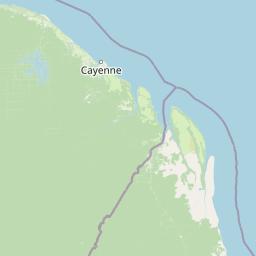
Park location guide

Geography guide, regional context, and park location map for Mont Grand Matoury Nature Reserve

Mont Grand Matoury Nature Reserve park geography, regions, and map view in France
Understand where Mont Grand Matoury Nature Reserve sits in France through a broader geographic reading of the surrounding landscape, nearby location context, and its mapped position within the national park landscape.

How Mont Grand Matoury Nature Reserve fits into France

France is a unitary semi-presidential republic and one of the world's largest economies. It borders Belgium, Luxembourg, Germany, Switzerland, Italy, Monaco, Andorra, and Spain, with a maritime border to the United Kingdom. The country is known for its cultural influence, art, cuisine, and political history spanning centuries.

Wider geography shaping Mont Grand Matoury Nature Reserve in France

France is located in Western Europe. Metropolitan France extends from the Rhine to the Atlantic Ocean and from the Mediterranean Sea to the English Channel and North Sea. The country borders Belgium, Luxembourg, Germany, Switzerland, Italy, Monaco, Andorra, Spain, and has a maritime border with the United Kingdom.

Map view of Mont Grand Matoury Nature Reserve

Use this park location map to pinpoint Mont Grand Matoury Nature Reserve in France, understand its exact geographic position, and read its mapped placement within the surrounding landscape more clearly.

Pigeon | © OpenStreetMap contributors

Location context for Mont Grand Matoury Nature Reserve

French Guiana
Park atlas

Compare Surrounding Protected Landscapes and Diverse Habitats in French Guiana

Explore Related Protected Areas Near Mont Grand Matoury Nature Reserve
After exploring Mont Grand Matoury Nature Reserve, delve into a curated list of nearby protected areas and similar conservation landscapes. Compare their distinct ecosystems, regional geography, and unique biodiversity to deepen your understanding of the Guiana Shield's natural heritage.
Nature reserveFrench Guiana

Trésor Regional Nature Reserve: Protected Nature Reserve in French Guiana's Guianas Region

Mapped Protected Landscape and Regional Geography

Investigate Trésor Regional Nature Reserve, a vital protected nature reserve located in French Guiana. This reserve is mapped as a significant component of the region's protected areas, contributing to the understanding of its unique tropical rainforest geography. Its designation underscores its importance for atlas exploration, offering structured insights into the natural landscapes that characterize this South American territory.

Area
24.64 km²
Established
2010
IUCN
IV
Relief
Mountain
Nature reserveFrench Guiana

Kaw-Roura Marshland Nature Reserve: A Protected Marshland Landscape in French Guiana

Explore its mapped terrain and regional geographic context.

Kaw-Roura Marshland Nature Reserve represents a distinct protected landscape within the tropical rainforests of French Guiana. This nature reserve offers detailed insights into marshland geography and terrain, contributing vital data for map-based exploration and understanding regional conservation patterns. Discover the specific protected boundaries and landscape character that define this important natural area, anchoring its identity within the larger geographic context of French Guiana.

Area
947 km²
Established
1998
IUCN
IV
Nature reserveFrench Guiana

Nouragues Nature Reserve: Protected Nature Reserve Landscape within French Guiana's Amazon

Mapped geography featuring a distinct inselberg formation.

Nouragues Nature Reserve stands as a critical protected area within French Guiana, safeguarding a significant expanse of pristine lowland tropical rainforest. Its most defining characteristic is the Nouragues Inselberg, a colossal granite formation that dramatically punctuates the dense forest canopy. This reserve is not only a testament to conservation efforts but also a globally recognized hub for tropical forest ecology research. Exploring Nouragues Nature Reserve offers a unique lens into the natural processes and geological features of the Guiana Shield ecosystems.

Area
1,000 km²
Established
1995
IUCN
IV
Relief
Mixed relief
Nature reserveFrench Guiana

La Trinité National Nature Reserve: French Guiana Protected Landscape & Nature Reserve Atlas

Mapping the natural terrain and protected boundaries.

Delve into the protected landscape of La Trinité National Nature Reserve, an integral part of French Guiana's extensive natural terrain. This explorer view provides specific insights into the reserve's mapped boundaries and its geographic context within the South American region. Understand its identity as a designated nature reserve and its contribution to the broader protected areas atlas for French Guiana.

Area
769.03 km²
Established
1996
IUCN
IV
Relief
Mountain
Watercolor painting of a landscape with rolling hills, green trees, and soft color gradients
National parkFrench Guiana

Guiana Amazonian Park National Park: French Guiana's Expansive Protected Rainforest

Explore mapped boundaries and regional geographic context.

Guiana Amazonian Park, a cornerstone of protected land in French Guiana, offers a profound exploration of untamed Amazonian rainforest. As the largest national park in the European Union, it showcases a vast, remote ecosystem characterized by towering trees and intricate river systems. This page provides detailed context on its geographic placement within French Guiana and its significance as a major protected landscape for atlas-based discovery and understanding of tropical forest conservation.

Area
20,300 km²
Established
2007
IUCN
II
Relief
Lowland
National parkSuriname

Brownsberg Nature Park: Suriname National Park with Tropical Forest and Waterfall Landscapes

Mapped geography and protected landscape context.

Brownsberg Nature Park stands as a vital protected landscape within Suriname, distinguished by its central mountain, tropical forest ecosystems, and scenic waterfalls such as Leo Waterfall. The park's location overlooking the vast Brokopondo Reservoir provides a unique geographic setting, making it an important destination for atlas and map-based exploration of Suriname's natural heritage. Understanding Brownsberg Nature Park offers insight into the Neotropical biodiversity and terrain characteristic of the Guianan moist forests.

Area
122 km²
Established
1969
IUCN
II
Visitors
20K annual
Nature reserveSipaliwini District

Central Suriname Nature Reserve: Protected Nature Reserve with Mapped Geographic Context

Explore the landscape boundaries within Sipaliwini District's protected areas.

Central Suriname Nature Reserve is a significant protected area situated in Suriname's Sipaliwini District. As a designated nature reserve, it offers critical insights into regional geography and conservation landscapes. This page provides focused information on its mapped boundaries and its contribution to the broader atlas of protected lands, enabling detailed geographic discovery.

Area
16,000 km²
Established
1998
Relief
Mixed relief
Climate
Tropical
National parkPotaro-Siparuni

Kaieteur National Park: Iconic South American Waterfall and Protected Forest Landscape

Discover the unique geography and mapped boundaries of this Guiana Shield natural wonder.

Kaieteur National Park is a significant protected area in Guyana, celebrated globally for Kaieteur Falls, the world's largest single-drop waterfall by volume. This national park preserves over 242 square miles of untouched tropical rainforest, offering critical habitat for endemic species and a profound example of the Guiana Shield's ancient geological formations and diverse ecosystems. Its location deep within the Potaro-Siparuni Region underscores its role as a vital bastion of wilderness and a landmark in South American protected landscapes.

Area
630 km²
Established
1929
IUCN
II
Relief
Mixed relief

Common questions about visiting, size, designation, and location context for Mont Grand Matoury Nature Reserve

Mont Grand Matoury Nature Reserve FAQs for park facts, access, geography, and protected area context
Find quick answers about Mont Grand Matoury Nature Reserve, including protected-area facts, park geography, trail and visitor context, and how the park fits into its surrounding country and regional landscape.
MoriAtlas Explorer

Continue Your Protected Areas Search Across the Global Atlas

Deepen your exploration by continuing the structured search for national parks and protected areas worldwide. Utilize the comprehensive filtering capabilities to compare different conservation landscapes and refine your understanding of global park geography. Discover more about the distribution and characteristics of protected natural areas.

Global natural geography