Mori Atlas logo
Nature reserveTrésor Regional Nature Reserve

Discover the mapped geography and protected natural context of this significant reserve.

Trésor Regional Nature Reserve: French Guiana's Protected Nature Reserve Landscape

(Réserve naturelle régionale Trésor)

Trésor Regional Nature Reserve stands as a distinct protected area within the vast tropical rainforests of French Guiana. This nature reserve contributes to the region's extensive network of protected lands, offering a glimpse into the mapped geography and natural landscape that defines this South American territory. As a component of France's outermost regions, its identity as a protected natural reserve is key to understanding its role in regional conservation and atlas exploration.

Tropical RainforestMountain ForestMarshlandFrench GuianaSouth AmericaNature Reserve

Trésor Regional Nature Reserve

Nature reserve

Park overview

Structured park overview, official facts, and landscape profile for Trésor Regional Nature Reserve

Trésor Regional Nature Reserve park facts, protected area profile, and essential visitor context
Review the core facts for Trésor Regional Nature Reserve, including designation, size, terrain, visitor scale, habitats, and operating context in one park-focused overview.

About Trésor Regional Nature Reserve

Trésor Regional Nature Reserve occupies a significant position in the protected area network of French Guiana, a French overseas department located on the northern coast of South America. The reserve is situated on the eastern slopes of Kaw Mountain, extending from the mountain itself down to the Orapu River. This location places the reserve within a transitional zone between coastal lowlands and the interior highlands, creating remarkable ecological diversity within a relatively compact area. The reserve was created following years of environmental advocacy after a proposed gold mining project by Cambior in 2006 sparked significant opposition from environmental organizations and the Palikur Amerindian community. The cancellation of the mining project by the President of France in 2008 and the subsequent designation of the area as a regional nature reserve in 2010 represent a important conservation victory for the region. The reserve now protects intact tropical forest ecosystems that form part of the larger Guianan moist forest ecoregion, recognized as one of the most biodiverse areas on Earth.

Quick facts and research context for Trésor Regional Nature Reserve

Trésor Regional Nature Reserve is located in French Guiana, France, on the commune of Roura near Kaw Mountain. The reserve covers 2,464 hectares and was established in 2010 as a regional nature reserve (IUCN category IV). The protected area encompasses mountain forest, marsh forest, and wet savanna ecosystems. The region experiences a tropical rainforest climate with annual rainfall between 1,700 and 2,000 millimeters, reaching up to 4,000 millimeters locally. The reserve is managed by the Association Trésor and contains a botanical trail for visitors.

Park context

Deeper park guide and search-rich context for Trésor Regional Nature Reserve

Trésor Regional Nature Reserve history, landscape, wildlife, and travel context
Explore Trésor Regional Nature Reserve through its history, landscape character, ecosystems, wildlife, conservation priorities, cultural context, and seasonal travel timing in a structured park guide built for atlas discovery and search intent.

Why Trésor Regional Nature Reserve stands out

Trésor Regional Nature Reserve is best known for its exceptional biodiversity and the variety of intact tropical ecosystems it protects. The reserve is renowned for its exceptional plant diversity with over 1,100 plant species documented, including rare and endemic species such as Vochysia neyratii and Astrocaryum rodreguiseii found in the forest areas at the mountain base. The reserve also stands out for the ecological significance of Kaw Mountain itself, which creates unique microclimatic conditions due to its interaction with trade winds, resulting in high humidity levels that sustain abundant life. The reserve's creation is particularly notable as it was established following widespread protests against a controversial gold mining project that would have cleared 30 square kilometers of old-growth forest.

Trésor Regional Nature Reserve history and protected-area timeline

The history of Trésor Regional Nature Reserve is closely tied to both the natural resource exploitation that characterized French Guiana in the late 19th century and modern conservation movements. In the late 1800s, the region attracted interest for its alluvial gold deposits, marking the beginning of human economic activity in what would become the reserve area. The modern chapter of the reserve's history began in 2006 when the Canadian mining company Cambior proposed a large-scale gold mining operation near Camp Caïman. The project would have involved clearing approximately 30 square kilometers of old-growth forest, drawing immediate criticism from environmental organizations and the Palikur Amerindian people who have traditional connections to the land. Following sustained protests and advocacy, French President Nicolas Sarkozy cancelled the project on January 30, 2008. This decision paved the way for permanent protection of the area, and on February 12, 2010, the General Council of French Guiana formally established the reserve as a regional nature reserve, marking the culmination of conservation efforts that spanned several years.

Trésor Regional Nature Reserve landscape and geographic character

The landscape of Trésor Regional Nature Reserve is defined by the presence of Kaw Mountain, a 337-meter-high peak that rises from the surrounding terrain and creates distinctive ecological conditions. The mountain acts as an obstacle to the trade winds, generating high humidity throughout the area and influencing the distribution of vegetation communities. The reserve encompasses three primary landscape types: mountain forest covering the slopes of Kaw Mountain, marsh forest in the lower-lying areas and drainage zones, and wet savanna areas that alternate with the forested sections. The terrain varies from gentle slopes at the mountain base to steeper inclines as elevation increases. The forest areas at the base of the mountain contain some of the most botanically significant habitats, with rare and endemic plant species occurring in these lower elevation zones. The reserve extends from the foothills of Kaw Mountain down toward the Orapu River, creating a contiguous protected landscape that spans multiple habitat types.

Trésor Regional Nature Reserve ecosystems, habitats, and plant life

The nature of Trésor Regional Nature Reserve is characterized by remarkable biodiversity and complex tropical ecosystem dynamics. The reserve contains seven distinct vegetation types: mountain summit forest, forest on gentle slopes, forest on steep slopes, temporarily flooded forest, marsh forest, isolated mountain forest, and wet savanna. This diversity of habitats supports exceptional species richness, with over 1,100 plant species documented within the reserve boundaries. The tropical rainforest climate features minimal temperature variation throughout the year, with average daytime temperatures around 18°C, while annual rainfall ranges from 1,700 to 2,000 millimeters with local peaks reaching 4,000 millimeters. The high humidity generated by Kaw Mountain's interaction with trade winds creates conditions that support lush vegetation and high productivity across all habitat types. The reserve forms part of the broader Guianan moist forest ecoregion, a global biodiversity hotspot known for its high concentration of endemic species.

Trésor Regional Nature Reserve wildlife and species highlights

The wildlife of Trésor Regional Nature Reserve is exceptionally diverse, with the reserve supporting substantial populations of mammals, birds, reptiles, amphibians, and insects. The reserve documents 101 mammal species, 312 bird species, 70 reptile species, 47 amphibian species, and 109 ant species. The avifauna is particularly noteworthy, featuring numerous iconic Neotropical species including the king vulture (Sarcoramphe roi), great condor, white hawk, fork-tailed kite, bat falcon, red-throated caracara, curassow, agami trumpeter, scarlet macaw, red-and-green macaw, squirrel cuckoo, spotted puffbird, and various cotingidae species. The bird community also includes numerous forest-dwelling passerines such as the slaty ani, buff-throated saltator, red-breasted meadowlark, greyish saltator, sooty grassquit, green honeycreeper, musician wren, and various hummingbirds, trogons, toucans, and manakins. The mammal community includes species typical of Amazonian and Guianan forests, while the reptile and amphibian populations reflect the extensive wetland and forest habitats present within the reserve.

Trésor Regional Nature Reserve conservation status and protection priorities

Trésor Regional Nature Reserve represents an important conservation achievement in French Guiana, protecting a significant area of intact tropical forest and associated ecosystems. The reserve's establishment in 2010 came directly as a result of successful opposition to a commercial mining project that would have caused substantial habitat destruction. The reserve is designated as IUCN category IV, reflecting its primary focus on habitat and species management. The protected area is part of a larger network of conservation lands in French Guiana, connecting with the adjacent Kaw-Roura Marshland Nature Reserve to form a comprehensive protected zone. The reserve protects significant biodiversity including numerous endemic plant species and provides essential habitat for wildlife populations. The management by Association Trustee ensures ongoing conservation activities and monitoring of the reserve's natural resources. The establishment of this regional nature reserve contributes to France's commitments to biodiversity protection and sustainable land management in its overseas territories.

Trésor Regional Nature Reserve cultural meaning and human context

The cultural context of Trésor Regional Nature Reserve includes the historical relationship between the local Palikur Amerindian people and the land now protected by the reserve. The Palikur community has traditional connections to the region and was actively involved in the opposition to the Cambior mining project that threatened the area in 2006-2008. Their involvement in the conservation movement highlights the important role that indigenous communities play in environmental protection in French Guiana. Additionally, the region has a historical legacy of gold mining interest dating to the late 19th century, when the alluvial gold deposits in the area attracted economic interest and settlement. This mining heritage contrasts with the modern conservation values that now guide the management of the reserve. The establishment of the botanical trail (sentier botanique) by volunteers from the Association Trustee represents a contemporary effort to connect people with the reserve's natural heritage while promoting environmental education.

Top sights and standout views in Trésor Regional Nature Reserve

Trésor Regional Nature Reserve stands out for its exceptional biodiversity concentrated in a relatively small area, with over 1,100 plant species and significant populations of mammals, birds, and reptiles. The reserve protects the slopes of Kaw Mountain, a notable geographical feature that creates unique humid conditions supporting lush tropical ecosystems. The reserve's establishment following the successful opposition to a major gold mining project represents an important conservation victory. The diverse habitat types ranging from mountain forest to marsh forest and savanna create a compact but comprehensive representation of Guianan tropical ecosystems. The botanical trail provides visitors with an opportunity to experience and learn about the reserve's natural treasures.

Best time to visit Trésor Regional Nature Reserve

The reserve can be visited year-round due to French Guiana's tropical climate, though the dry season from approximately August to November typically offers more comfortable conditions for outdoor exploration. The wet season from December to July brings higher rainfall but also maintains the lush, green character of the forest that makes the reserve visually striking. Visitors interested in wildlife observation may find different advantages in each season, as the dry season often brings animals to water sources while the wet season showcases the full vitality of the forest ecosystem. The botanical trail can be enjoyed in any season, though appropriate footwear and preparation for tropical conditions are recommended year-round.
Park location guide

Geography guide, regional context, and park location map for Trésor Regional Nature Reserve

Trésor Regional Nature Reserve park geography, regions, and map view in France
Understand where Trésor Regional Nature Reserve sits in France through a broader geographic reading of the surrounding landscape, nearby location context, and its mapped position within the national park landscape.

How Trésor Regional Nature Reserve fits into France

France is a unitary semi-presidential republic and one of the world's largest economies. It borders Belgium, Luxembourg, Germany, Switzerland, Italy, Monaco, Andorra, and Spain, with a maritime border to the United Kingdom. The country is known for its cultural influence, art, cuisine, and political history spanning centuries.

Wider geography shaping Trésor Regional Nature Reserve in France

France is located in Western Europe. Metropolitan France extends from the Rhine to the Atlantic Ocean and from the Mediterranean Sea to the English Channel and North Sea. The country borders Belgium, Luxembourg, Germany, Switzerland, Italy, Monaco, Andorra, Spain, and has a maritime border with the United Kingdom.

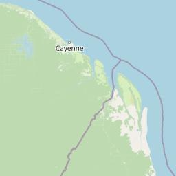
Map view of Trésor Regional Nature Reserve

Use this park location map to pinpoint Trésor Regional Nature Reserve in France, understand its exact geographic position, and read its mapped placement within the surrounding landscape more clearly.

Pigeon | © OpenStreetMap contributors

Location context for Trésor Regional Nature Reserve

French Guiana
Park atlas

Map the regional geography of protected areas, comparing diverse tropical ecosystems near Trésor Regional Nature Reserve in French Guiana.

Discover Other National Parks and Protected Areas Near Trésor Regional Nature Reserve
Explore additional national parks and protected areas geographically adjacent to or within the broader regional context of Trésor Regional Nature Reserve, tracing the unique distribution of Guianan tropical ecosystems. This module helps you compare varied conservation landscapes, from mountain forests to marshlands, and understand their interconnected role in South American biodiversity.
Nature reserveFrench Guiana

Kaw-Roura Marshland Nature Reserve: A Protected Marshland Landscape in French Guiana

Explore its mapped terrain and regional geographic context.

Kaw-Roura Marshland Nature Reserve represents a distinct protected landscape within the tropical rainforests of French Guiana. This nature reserve offers detailed insights into marshland geography and terrain, contributing vital data for map-based exploration and understanding regional conservation patterns. Discover the specific protected boundaries and landscape character that define this important natural area, anchoring its identity within the larger geographic context of French Guiana.

Area
947 km²
Established
1998
IUCN
IV
Nature reserveFrench Guiana

Mont Grand Matoury Nature Reserve: French Guiana's Protected Landscape and Mapped Geography

Explore its protected boundaries and regional terrain.

Mont Grand Matoury Nature Reserve is an integral part of the protected areas network in French Guiana, offering a specific focus on its natural landscape and geographic setting. This entry provides a structured overview of the reserve, detailing its mapped extent and its contribution to the regional geography. Users can delve into the specifics of this protected land, understanding its character and location within the wider context of France's overseas territories and the Amazonian biome.

Area
21.23 km²
Established
2006
IUCN
IV
Relief
Mixed relief
Nature reserveFrench Guiana

Nouragues Nature Reserve: Protected Nature Reserve Landscape within French Guiana's Amazon

Mapped geography featuring a distinct inselberg formation.

Nouragues Nature Reserve stands as a critical protected area within French Guiana, safeguarding a significant expanse of pristine lowland tropical rainforest. Its most defining characteristic is the Nouragues Inselberg, a colossal granite formation that dramatically punctuates the dense forest canopy. This reserve is not only a testament to conservation efforts but also a globally recognized hub for tropical forest ecology research. Exploring Nouragues Nature Reserve offers a unique lens into the natural processes and geological features of the Guiana Shield ecosystems.

Area
1,000 km²
Established
1995
IUCN
IV
Relief
Mixed relief
Nature reserveFrench Guiana

La Trinité National Nature Reserve: French Guiana Protected Landscape & Nature Reserve Atlas

Mapping the natural terrain and protected boundaries.

Delve into the protected landscape of La Trinité National Nature Reserve, an integral part of French Guiana's extensive natural terrain. This explorer view provides specific insights into the reserve's mapped boundaries and its geographic context within the South American region. Understand its identity as a designated nature reserve and its contribution to the broader protected areas atlas for French Guiana.

Area
769.03 km²
Established
1996
IUCN
IV
Relief
Mountain
Watercolor painting of a landscape with rolling hills, green trees, and soft color gradients
National parkFrench Guiana

Guiana Amazonian Park National Park: French Guiana's Expansive Protected Rainforest

Explore mapped boundaries and regional geographic context.

Guiana Amazonian Park, a cornerstone of protected land in French Guiana, offers a profound exploration of untamed Amazonian rainforest. As the largest national park in the European Union, it showcases a vast, remote ecosystem characterized by towering trees and intricate river systems. This page provides detailed context on its geographic placement within French Guiana and its significance as a major protected landscape for atlas-based discovery and understanding of tropical forest conservation.

Area
20,300 km²
Established
2007
IUCN
II
Relief
Lowland
National parkSuriname

Brownsberg Nature Park: Suriname National Park with Tropical Forest and Waterfall Landscapes

Mapped geography and protected landscape context.

Brownsberg Nature Park stands as a vital protected landscape within Suriname, distinguished by its central mountain, tropical forest ecosystems, and scenic waterfalls such as Leo Waterfall. The park's location overlooking the vast Brokopondo Reservoir provides a unique geographic setting, making it an important destination for atlas and map-based exploration of Suriname's natural heritage. Understanding Brownsberg Nature Park offers insight into the Neotropical biodiversity and terrain characteristic of the Guianan moist forests.

Area
122 km²
Established
1969
IUCN
II
Visitors
20K annual
Nature reserveSipaliwini District

Central Suriname Nature Reserve: Protected Nature Reserve with Mapped Geographic Context

Explore the landscape boundaries within Sipaliwini District's protected areas.

Central Suriname Nature Reserve is a significant protected area situated in Suriname's Sipaliwini District. As a designated nature reserve, it offers critical insights into regional geography and conservation landscapes. This page provides focused information on its mapped boundaries and its contribution to the broader atlas of protected lands, enabling detailed geographic discovery.

Area
16,000 km²
Established
1998
Relief
Mixed relief
Climate
Tropical
Protected areaGuyana

Kanashen Protected Area: Geographic Identity and Mapped Boundaries in Guyana

Explore the mapped landscape and protected land context.

Kanashen Protected Area serves as a critical point of geographic discovery within Guyana, offering detailed insights into its protected boundaries and natural landscape. This entry focuses on providing a structured, atlas-driven understanding of Kanashen, emphasizing its role within the regional geography of South America. Users can explore how this protected area fits into the larger mapped context, appreciating its specific terrain and conservation significance.

Area
6,485.67 km²
IUCN
VI
Relief
Mixed relief
Climate
Tropical

Common questions about visiting, size, designation, and location context for Trésor Regional Nature Reserve

Trésor Regional Nature Reserve FAQs for park facts, access, geography, and protected area context
Find quick answers about Trésor Regional Nature Reserve, including protected-area facts, park geography, trail and visitor context, and how the park fits into its surrounding country and regional landscape.
MoriAtlas Explorer

Continue Your Protected Areas Search Across the Global Atlas

Deepen your exploration by continuing the structured search for national parks and protected areas worldwide. Utilize the comprehensive filtering capabilities to compare different conservation landscapes and refine your understanding of global park geography. Discover more about the distribution and characteristics of protected natural areas.

Global natural geography