Mori Atlas logo
Nature reserveKaw-Roura Marshland Nature Reserve

Mapping the protected marshland terrain and regional context within French Guiana's expansive rainforests.

Kaw-Roura Marshland Nature Reserve: Protected Landscape and Geographic Identity in French Guiana

(Réserve naturelle nationale des marais de Kaw-Roura)

Kaw-Roura Marshland Nature Reserve stands as a significant protected area within the vast geographical expanse of French Guiana. This nature reserve offers a unique glimpse into the region's diverse marshland terrain, contributing to the intricate tapestry of protected landscapes found across South America. Understanding its mapped boundaries and ecological setting provides crucial context for atlas-based exploration of French Guiana's remarkable natural heritage and its role as a European Union outermost region.

wetland reserveRamsar sitetropical wetlandAmazon basinFrench Guianamangrove ecosystem

Kaw-Roura Marshland Nature Reserve

Nature reserve

Park overview

Structured park overview, official facts, and landscape profile for Kaw-Roura Marshland Nature Reserve

Kaw-Roura Marshland Nature Reserve park facts, protected area profile, and essential visitor context
Review the core facts for Kaw-Roura Marshland Nature Reserve, including designation, size, terrain, visitor scale, habitats, and operating context in one park-focused overview.

About Kaw-Roura Marshland Nature Reserve

Kaw-Roura Marshland Nature Reserve represents one of French Guiana's most important conservation achievements and a flagship protected area for wetland ecology in tropical South America. The reserve occupies a strategic position along the Atlantic coast of French Guiana, extending inland from the ocean to the edge of the Amazonian rainforest, and encompasses portions of the communes of Roura and Régina. The aquatic landscape is dominated by floating savanna marshes characterized by Cyperus species and mucoucou trees (Montrichardia arborescens), creating a dynamic wetland environment that shifts with seasonal water level fluctuations. This wetland system is fed by several watercourses including the Kaw River, the Approuague River, and the Angélique Creek, which together maintain the hydrological integrity of the marshland complex. The reserve's vast size and ecological diversity have established it as a cornerstone of French Guiana's environmental protection strategy, supporting both biodiversity conservation and scientific research into tropical wetland ecosystems.

Quick facts and research context for Kaw-Roura Marshland Nature Reserve

Kaw-Roura Marshland Nature Reserve covers 94,700 hectares along the Atlantic coast of French Guiana, making it the largest wetland in France and the third-largest nature reserve in the country. The protected area encompasses the Kaw River basin, portions of the Approuague River, and the Angélique Creek, creating an intricate network of aquatic habitats. Established as a nature reserve in 1998, the site had already achieved Ramsar designation in 1993, recognizing its international importance as a wetland ecosystem. The reserve contains the village of Kaw, one of the few inhabited settlements located within a French national nature reserve. The Montagne de Kaw, a prominent geographic feature within the reserve, records the highest rainfall in French Guiana and served as a biodiversity refuge during Pleistocene drought periods.

Park context

Deeper park guide and search-rich context for Kaw-Roura Marshland Nature Reserve

Kaw-Roura Marshland Nature Reserve history, landscape, wildlife, and travel context
Explore Kaw-Roura Marshland Nature Reserve through its history, landscape character, ecosystems, wildlife, conservation priorities, cultural context, and seasonal travel timing in a structured park guide built for atlas discovery and search intent.

Why Kaw-Roura Marshland Nature Reserve stands out

Kaw-Roura is best known for its exceptional biodiversity and as the premier wetland conservation area in France. The reserve harbors 535 bird species, representing 74% of all bird species recorded in French Guiana, making it a globally significant area for waterbird populations and a critical breeding and wintering habitat. It is particularly famous for supporting concentrations of herons, egrets, and the striking agami heron. The reserve also protects substantial populations of black caiman, the largest member of the alligator family in South America, and serves as a sanctuary for this species. The coexistence of diverse ecosystems including mangrove, savanna, marshland, and rainforest within a single protected area creates a unique ecological landscape that distinguishes Kaw-Roura from other protected areas in the region.

Kaw-Roura Marshland Nature Reserve history and protected-area timeline

The protection history of Kaw-Roura Marshland reflects evolving French environmental policy toward Amazonian territories. The site received initial protection through a prefectoral biotope protection order in 1989, establishing the first formal recognition of the area's ecological significance. This initial protection was superseded by the formal creation of the national nature reserve through decree 98-166 on March 13, 1998, elevating the site to full national protection status. The reserve had already achieved international recognition through its designation as a Ramsar site on December 8, 1993, making it part of the global network of wetlands of international importance. The reserve's management has undergone transitions, initially managed by the Regional Natural Park of French Guiana, with the reserve house opening to visitors in 2015 following two years of renovation work after a period of closure. In 2022, management transferred to a consortium formed by the Conservatoire d'espaces naturels de Guyane and two local municipalities, reflecting a shift toward decentralized conservation management. The Montagne de Kaw area within the reserve holds particular historical significance, having served as a refuge for flora and fauna during Pleistocene dry periods when surrounding lowlands likely became inhospitable.

Kaw-Roura Marshland Nature Reserve landscape and geographic character

The physical landscape of Kaw-Roura Marshland Nature Reserve presents a complex mosaic of wetland and forest environments shaped by the interaction of fluvial and coastal processes. The reserve spans from the Atlantic coastline inland, incorporating a transition zone where coastal mangrove ecosystems give way to extensive freshwater marshes and ultimately to tropical rainforest. The floating savanna marshes, characterized by vegetation adapted to permanent or seasonal inundation, represent the most distinctive landscape feature, with emergent herbaceous plants creating a visually striking environment that changes dramatically with water levels. The mangrove forests occupy the coastal fringe where saltwater and freshwater mixing creates unique halophytic vegetation communities. Rolling savanna areas within the reserve provide relief from the wetlands, supporting grassland ecosystems that flood seasonally. The Montagne de Kaw rises as a prominent topographic feature within the reserve, receiving the highest rainfall in French Guiana and supporting distinct montane vegetation communities. The network of rivers and creeks, particularly the Kaw River and its tributaries, dissects the landscape and provides the hydrological foundation for the wetland system.

Kaw-Roura Marshland Nature Reserve ecosystems, habitats, and plant life

The ecological character of Kaw-Roura is defined by the coexistence of multiple distinct habitat types within a single protected landscape. The marshland ecosystem represents the core of the reserve, with floating savanna vegetation dominated by Cyperus species and the arborescent mucoucou creating a unique wetland environment. The mangrove forests along the coastal margin support specialized salt-tolerant species and provide critical habitat for coastal and marine species. The tropical rainforest that adjoins the wetland areas represents the northern extension of the Amazonian forest, adding another dimension to the reserve's ecological diversity. This habitat mosaic supports extraordinary biodiversity, with the reserve containing more than half of all protected species in French Guiana. The aquatic carnivorous plants including various Utricularia species represent a particularly noteworthy component of the wetland flora, adapted to nutrient-poor conditions. Water hyacinth (Eichhornia) occurs naturally within the ecosystem, unlike its invasive status in many other tropical regions, demonstrating the ecological balance maintained within this protected area.

Kaw-Roura Marshland Nature Reserve wildlife and species highlights

The wildlife community of Kaw-Roura Marshland Nature Reserve is exceptionally diverse, with the protected area supporting significant populations of flagship and endemic species. The reptile fauna is particularly noteworthy, with four caiman species present including the black caiman, which reaches significant population sizes within the reserve. The amphibian community includes 74 species while reptiles total 103 species, reflecting the exceptional herpetofaunal diversity of this wetland system. Mammal populations are substantial, with 98 species recorded including remarkable representatives such as the Amazonian manatee, giant otter, and jaguar, all three representing conservation priorities. The bird fauna is especially significant, with 535 species recorded representing 74% of French Guiana's avifauna, making the reserve a critical area for waterbird conservation. Notable bird species include the cocoi heron, agami heron, great egret, cock-of-the-rock, and crested eagle, with the reserve serving as an important breeding and wintering location for migratory waterbirds. The fish community includes the electric eel (gymnotus), and the region supports unusual species such as the hoatzin, a primitive bird species.

Kaw-Roura Marshland Nature Reserve conservation status and protection priorities

Kaw-Roura Marshland Nature Reserve holds significant conservation importance at both national and international levels, serving as a flagship protected area for wetland conservation in France and the wider Amazon region. The Ramsar designation since 1993 recognizes the site's international importance as a wetland ecosystem, committing France to maintaining the ecological character of this area. The reserve protects more than half of all protected species in French Guiana, demonstrating its exceptional role in biodiversity conservation within the department. The black caiman population represents a particular conservation success, with the reserve serving as a sanctuary for this large predator that has been extirpated from many parts of its former range. The protected area also contributes to broader conservation objectives by maintaining connectivity between coastal and inland ecosystems, supporting seasonal migrations of wildlife, and preserving genetic diversity in an era of accelerating habitat loss. The transition to management by the Conservatoire d'espaces naturels de Guyane and local municipalities represents a commitment to integrating conservation with local community involvement.

Kaw-Roura Marshland Nature Reserve cultural meaning and human context

The human dimension of Kaw-Roura Marshland Nature Reserve includes both historical and contemporary cultural elements that shape the landscape's identity. The region of Kaw was originally inhabited by Amerindian peoples, who were the first human inhabitants of this wetland environment. European exploration of the area began in the late sixteenth century, with colonization of the Kaw region occurring from the eighteenth century onward. The village of Kaw, located within the reserve's boundaries, represents a unique case of a inhabited settlement within a French national nature reserve, creating a relationship between human community and protected landscape that requires careful management. Traditional activities such as fishing and small-scale agriculture have historically been practiced in the area, though these activities are now regulated within the reserve's management framework. The reserve house, which opened in 2015 and subsequently experienced closures including during the COVID-19 pandemic, serves as an interface between visitors and the protected area, providing educational context about the reserve's natural and cultural values.

Top sights and standout views in Kaw-Roura Marshland Nature Reserve

The Kaw-Roura Marshland Nature Reserve stands out as the largest and most ecologically diverse wetland in France, offering visitors an immersive experience in a tropical wetland environment that rivals the famous Everglades of North America. The opportunity to explore the marshland by traditional pirogue or canoe provides access to a pristine aquatic environment where wildlife observation opportunities are exceptional, particularly for waterbirds, caimans, and aquatic mammals. The reserve's location within the Amazon basin places it at the intersection of South American and Guianan biogeographic provinces, creating conditions that support extraordinary species diversity. The presence of the village of Kaw within the reserve offers a unique cultural dimension, allowing visitors to experience a traditional community living within a protected natural area. The Ramsar designation provides international recognition of the wetland's significance, while the presence of Montagne de Kaw with its exceptional rainfall adds a distinctive topographic element to the reserve.

Best time to visit Kaw-Roura Marshland Nature Reserve

The optimal time to visit Kaw-Roura Marshland Nature Reserve depends on the experience sought, with different seasons offering distinct advantages for exploration. The dry season, typically from August to November, generally provides easier navigation through the wetland channels and greater visibility for wildlife observation as water levels are lower and animals concentrate around remaining water sources. This period often offers more comfortable conditions for outdoor activities and boat excursions. The wet season brings higher water levels that flood extended areas of savanna, creating a different landscape character and potentially offering opportunities to observe aquatic species in their flooded forest habitats. The transitional periods between seasons can also provide rewarding visits, though visitors should be aware that the reserve's accessibility is always dependent on water conditions given its wetland character. The morning hours typically offer the best wildlife viewing opportunities as animals are most active and misty conditions over the water create evocative scenes for photography and observation.
Park location guide

Geography guide, regional context, and park location map for Kaw-Roura Marshland Nature Reserve

Kaw-Roura Marshland Nature Reserve park geography, regions, and map view in France
Understand where Kaw-Roura Marshland Nature Reserve sits in France through a broader geographic reading of the surrounding landscape, nearby location context, and its mapped position within the national park landscape.

How Kaw-Roura Marshland Nature Reserve fits into France

France is a unitary semi-presidential republic and one of the world's largest economies. It borders Belgium, Luxembourg, Germany, Switzerland, Italy, Monaco, Andorra, and Spain, with a maritime border to the United Kingdom. The country is known for its cultural influence, art, cuisine, and political history spanning centuries.

Wider geography shaping Kaw-Roura Marshland Nature Reserve in France

France is located in Western Europe. Metropolitan France extends from the Rhine to the Atlantic Ocean and from the Mediterranean Sea to the English Channel and North Sea. The country borders Belgium, Luxembourg, Germany, Switzerland, Italy, Monaco, Andorra, Spain, and has a maritime border with the United Kingdom.

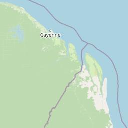
Map view of Kaw-Roura Marshland Nature Reserve

Use this park location map to pinpoint Kaw-Roura Marshland Nature Reserve in France, understand its exact geographic position, and read its mapped placement within the surrounding landscape more clearly.

Pigeon | © OpenStreetMap contributors

Location context for Kaw-Roura Marshland Nature Reserve

French Guiana
Park atlas

Map regional park geography and connected protected landscapes in French Guiana and the wider Amazon basin, expanding your exploration from this vital wetland.

Explore Nearby Protected Areas and Similar Landscapes to Kaw-Roura Marshland Nature Reserve
Expand your park discovery beyond Kaw-Roura Marshland Nature Reserve by exploring other significant protected areas in French Guiana and the surrounding Amazon basin. Compare mapped park geography and conservation landscapes to understand the regional spread of protected areas, offering valuable context for ecological patterns and biodiversity corridors.
Nature reserveFrench Guiana

Trésor Regional Nature Reserve: Protected Nature Reserve in French Guiana's Guianas Region

Mapped Protected Landscape and Regional Geography

Investigate Trésor Regional Nature Reserve, a vital protected nature reserve located in French Guiana. This reserve is mapped as a significant component of the region's protected areas, contributing to the understanding of its unique tropical rainforest geography. Its designation underscores its importance for atlas exploration, offering structured insights into the natural landscapes that characterize this South American territory.

Area
24.64 km²
Established
2010
IUCN
IV
Relief
Mountain
Nature reserveFrench Guiana

Mont Grand Matoury Nature Reserve: French Guiana's Protected Landscape and Mapped Geography

Explore its protected boundaries and regional terrain.

Mont Grand Matoury Nature Reserve is an integral part of the protected areas network in French Guiana, offering a specific focus on its natural landscape and geographic setting. This entry provides a structured overview of the reserve, detailing its mapped extent and its contribution to the regional geography. Users can delve into the specifics of this protected land, understanding its character and location within the wider context of France's overseas territories and the Amazonian biome.

Area
21.23 km²
Established
2006
IUCN
IV
Relief
Mixed relief
Nature reserveFrench Guiana

Nouragues Nature Reserve: Protected Nature Reserve Landscape within French Guiana's Amazon

Mapped geography featuring a distinct inselberg formation.

Nouragues Nature Reserve stands as a critical protected area within French Guiana, safeguarding a significant expanse of pristine lowland tropical rainforest. Its most defining characteristic is the Nouragues Inselberg, a colossal granite formation that dramatically punctuates the dense forest canopy. This reserve is not only a testament to conservation efforts but also a globally recognized hub for tropical forest ecology research. Exploring Nouragues Nature Reserve offers a unique lens into the natural processes and geological features of the Guiana Shield ecosystems.

Area
1,000 km²
Established
1995
IUCN
IV
Relief
Mixed relief
Nature reserveFrench Guiana

La Trinité National Nature Reserve: French Guiana Protected Landscape & Nature Reserve Atlas

Mapping the natural terrain and protected boundaries.

Delve into the protected landscape of La Trinité National Nature Reserve, an integral part of French Guiana's extensive natural terrain. This explorer view provides specific insights into the reserve's mapped boundaries and its geographic context within the South American region. Understand its identity as a designated nature reserve and its contribution to the broader protected areas atlas for French Guiana.

Area
769.03 km²
Established
1996
IUCN
IV
Relief
Mountain
Watercolor painting of a landscape with rolling hills, green trees, and soft color gradients
National parkFrench Guiana

Guiana Amazonian Park National Park: French Guiana's Expansive Protected Rainforest

Explore mapped boundaries and regional geographic context.

Guiana Amazonian Park, a cornerstone of protected land in French Guiana, offers a profound exploration of untamed Amazonian rainforest. As the largest national park in the European Union, it showcases a vast, remote ecosystem characterized by towering trees and intricate river systems. This page provides detailed context on its geographic placement within French Guiana and its significance as a major protected landscape for atlas-based discovery and understanding of tropical forest conservation.

Area
20,300 km²
Established
2007
IUCN
II
Relief
Lowland
National parkSuriname

Brownsberg Nature Park: Suriname National Park with Tropical Forest and Waterfall Landscapes

Mapped geography and protected landscape context.

Brownsberg Nature Park stands as a vital protected landscape within Suriname, distinguished by its central mountain, tropical forest ecosystems, and scenic waterfalls such as Leo Waterfall. The park's location overlooking the vast Brokopondo Reservoir provides a unique geographic setting, making it an important destination for atlas and map-based exploration of Suriname's natural heritage. Understanding Brownsberg Nature Park offers insight into the Neotropical biodiversity and terrain characteristic of the Guianan moist forests.

Area
122 km²
Established
1969
IUCN
II
Visitors
20K annual
Nature reserveSipaliwini District

Central Suriname Nature Reserve: Protected Nature Reserve with Mapped Geographic Context

Explore the landscape boundaries within Sipaliwini District's protected areas.

Central Suriname Nature Reserve is a significant protected area situated in Suriname's Sipaliwini District. As a designated nature reserve, it offers critical insights into regional geography and conservation landscapes. This page provides focused information on its mapped boundaries and its contribution to the broader atlas of protected lands, enabling detailed geographic discovery.

Area
16,000 km²
Established
1998
Relief
Mixed relief
Climate
Tropical
Protected areaGuyana

Kanashen Protected Area: Geographic Identity and Mapped Boundaries in Guyana

Explore the mapped landscape and protected land context.

Kanashen Protected Area serves as a critical point of geographic discovery within Guyana, offering detailed insights into its protected boundaries and natural landscape. This entry focuses on providing a structured, atlas-driven understanding of Kanashen, emphasizing its role within the regional geography of South America. Users can explore how this protected area fits into the larger mapped context, appreciating its specific terrain and conservation significance.

Area
6,485.67 km²
IUCN
VI
Relief
Mixed relief
Climate
Tropical

Common questions about visiting, size, designation, and location context for Kaw-Roura Marshland Nature Reserve

Kaw-Roura Marshland Nature Reserve FAQs for park facts, access, geography, and protected area context
Find quick answers about Kaw-Roura Marshland Nature Reserve, including protected-area facts, park geography, trail and visitor context, and how the park fits into its surrounding country and regional landscape.
MoriAtlas Explorer

Continue Your Protected Areas Search Across the Global Atlas

Deepen your exploration by continuing the structured search for national parks and protected areas worldwide. Utilize the comprehensive filtering capabilities to compare different conservation landscapes and refine your understanding of global park geography. Discover more about the distribution and characteristics of protected natural areas.

Global natural geography