

Mori Atlas logo
National parkMoore River National Park

Discover the mapped boundaries and natural terrain of this protected area in Western Australia.

Moore River National Park: National Park Protected Landscape and Geographic Context

Moore River National Park stands as a protected national park entity within the diverse geography of Western Australia. This page offers a focused exploration of its specific geographic identity, providing mapped landscape context and details relevant for understanding its protected area status within the broader Australian atlas. Delve into the natural terrain and regional significance of this conservation landscape.

Banksia HeathlandWestern AustraliaWheatbeltNational ParkProtected AreaRiparian Corridor

Moore River National Park

National park

Park overview

Structured park overview, official facts, and landscape profile for Moore River National Park

Moore River National Park park facts, protected area profile, and essential visitor context

Review the core facts for Moore River National Park, including designation, size, terrain, visitor scale, habitats, and operating context in one park-focused overview.

About Moore River National Park

Moore River National Park protects a representative example of the Banksia woodland and heathland ecosystems that historically covered much of the Swan Coastal Plain between Perth and Geraldton in Western Australia. The park's position in the Wheatbelt places it within a region that has experienced extensive agricultural development, making the protected area an important remnant of native vegetation in a largely cleared landscape. The Moore River, which flows through the park, serves as a natural drainage line carrying winter rainfall and seasonal flow from the inland catchment toward the coast. The river's passage through the park creates a ribbon of more lush vegetation along its banks, contrasting with the open heathland that dominates the surrounding terrain. This combination of riverine and heathland habitats contributes to the park's ecological diversity and makes it a valuable conservation area within the Wheatbelt. The park remains undeveloped for tourism, with no constructed facilities such as parking areas, picnic sites, or walking tracks provided for visitors.

Quick facts and research context for Moore River National Park

Moore River National Park occupies a substantial tract of Western Australia's Wheatbelt, located west of the Brand Highway near Regans Ford. The park was formally established in 1969 and covers approximately 172.54 square kilometres of predominantly banksia heathland. The Moore River flows through the reserve, providing a permanent water source and a natural corridor connecting the inland heathlands to the coastal zone near Guilderton. The park falls under IUCN Category II protection as a national park and remains undeveloped, with no visitor facilities provided within its boundaries.

Protection and recognition

Verifying terrestrial conservation scope and official designation records for the protected area.

Moore River National Park Documented Protection Status and Conservation Profile

Documented records trace the terrestrial protection status and conservation parameters of Moore River National Park within the Australian ecological system. Verifying official management scopes and tracking global designation sources offers crucial geographic context for understanding the long-term status of critical terrestrial landscapes.

Protection details

Protection scope
Terrestrial
Transboundary protection
No
Park context

Deeper park guide and search-rich context for Moore River National Park

Moore River National Park history, landscape, wildlife, and travel context

Explore Moore River National Park through its history, landscape character, ecosystems, wildlife, conservation priorities, cultural context, and seasonal travel timing in a structured park guide built for atlas discovery and search intent.

Why Moore River National Park stands out

The park is most notable for its extensive banksia heathland, a characteristically Australian Mediterranean-climate vegetation type that dominates much of the Swan Coastal Plain. The heathland here supports a diverse array of endemic plant species adapted to the nutrient-poor sandy soils of the region. The park's location along the Moore River corridor adds further ecological value, creating a riparian zone that contrasts with the surrounding heath and provides habitat for different species assemblages. The park represents one of the more significant protected areas of banksia heathland in the Wheatbelt region.

Moore River National Park history and protected-area timeline

Moore River National Park was established in 1969 through formal declaration under Western Australian legislation, creating a protected area that encompassed the banksia heathland and river corridor in the northern Wheatbelt. The establishment of the park reflected growing recognition during the 1960s of the need to preserve representative examples of Western Australia's unique Mediterranean-climate ecosystems. At the time of establishment, much of the surrounding Wheatbelt had already been cleared for agriculture, making the protection of remaining native vegetation patches increasingly important. The park was placed under the management of the Western Australian Department of Parks and Wildlife, which continues to administer the reserve as part of the state's protected area network. The park's boundaries encompass both the heathland uplands and the river corridor, though the park does not extend to the coast where the Moore River meets the Indian Ocean near Guilderton.

Moore River National Park landscape and geographic character

The park occupies a gently undulating landscape on the Swan Coastal Plain, characterised by low relief and sandy soils derived from ancient marine and alluvial deposits. The terrain is generally flat to subtly undulating, with the Moore River cutting a shallow valley as it makes its way toward the coast. The banksia heathland dominates the upland areas, forming a dense to open shrubland where banksia species are the dominant canopy plants. The understory typically includes various shrubs, grasses, and herbaceous species adapted to the acidic, low-nutrient soils. Along the river corridor, the vegetation changes to include more mesic species, with the presence of denser shrub layers and a different composition of ground cover plants where moisture is more available. The overall landscape presents as a relatively uniform heathland plain broken by the linear green corridor of the river.

Moore River National Park ecosystems, habitats, and plant life

The banksia heathland of Moore River National Park represents a distinctive Mediterranean-climate ecosystem characterised by low, sclerophyllous shrubs and an open canopy dominated by various Banksia species. This vegetation type is adapted to the long, dry summers and winter rainfall pattern of south-western Australia, with many species exhibiting drought-resistant features such as hard leaves and deep root systems. The heathland supports a characteristic suite of plant species including numerous endemics that are restricted to the Swan Coastal Plain region. The river corridor introduces additional ecological complexity, providing habitat for species that require permanent water or more moisture-laden environments. The park's position within the Wheatbelt, surrounded by cleared agricultural land, means it functions as a refuge for native species in a fragmented landscape.

Moore River National Park wildlife and species highlights

The banksia heathland and river corridor of Moore River National Park provide habitat for various native animal species, though the source material provides limited specific detail about particular wildlife present. The park would be expected to support populations of smaller mammals, reptiles, and invertebrates typical of the Swan Coastal Plain heathland, as well as bird species that inhabit sclerophyllous shrubland and riparian areas. The permanent water presence of the Moore River would attract waterfowl and other bird species that utilise riverine habitats. The fragmented nature of the surrounding landscape means the park likely serves as an important habitat refugium for native wildlife in the agricultural Wheatbelt region.

Moore River National Park conservation status and protection priorities

Moore River National Park represents a significant conservation value as a relatively intact example of banksia heathland in a region that has been extensively cleared for agriculture. The park protects representative examples of the Swan Coastal Plain's characteristic vegetation communities and provides habitat for native species in a landscape where native vegetation cover has been dramatically reduced. The protection of the Moore River corridor through the park adds further conservation value by preserving a natural drainage system and associated riparian vegetation. The park's IUCN Category II designation reflects its national significance as a protected area, though the source material does not detail specific conservation programs or management challenges.

Moore River National Park cultural meaning and human context

The park takes its name from the Moore River, which flows through the reserve. The river and surrounding region have been part of the traditional Country of Noongar peoples, who have inhabited the south-west of Western Australia for thousands of years. The park's proximity to Guilderton, a small coastal township at the mouth of the Moore River, reflects the historical relationship between the river system and human settlement in the region. While the source material does not provide detailed cultural context, the broader Wheatbelt region contains areas of indigenous significance, and the landscape would have supported traditional Noongar land use and cultural practices prior to European settlement.

Top sights and standout views in Moore River National Park

The park's primary highlight is its extensive banksia heathland, one of the more significant protected examples of this ecosystem in the Wheatbelt region. The Moore River corridor provides a contrasting landscape element, offering a natural watercourse that threads through the heathland before reaching the coast. The park's location approximately 95 kilometres north of Perth makes it accessible for day visits, though the absence of facilities means visitors should be prepared for a undeveloped experience. The combination of heathland and riverine habitats creates ecological diversity within a single protected area.

Best time to visit Moore River National Park

The park can be visited year-round, though the winter and spring months from June to November typically offer the most pleasant conditions for exploring the heathland landscapes. During this period, the cooler temperatures and any rainfall create greener, more vibrant conditions across the heathland, and wildflower displays may occur in spring. Summer months from December to February can be hot and dry, with the heathland appearing more muted and the risk of bushfire increased. The absence of facilities means visitors should bring all supplies and be self-sufficient. The park's proximity to Perth makes it suitable for day trips, though the lack of amenities means visitors should plan accordingly.
Monthly climate preview

Long-term temperature ranges and monthly precipitation averages for Western Australia

Moore River National Park Climate Normals and Annual Weather Patterns

Moore River National Park exhibits measured annual temperature variations and monthly precipitation rhythms based on long-term representative coordinate data. Examining the complete twelve-month climate profile reveals detailed temperature extremes and precipitation shifts across the protected area.
Annual mean19 °C
13 °C26 °C
Jan26°
Feb26°
Mar24°
Apr21°
May17°
Jun14°
Jul13°
Aug13°
Sep14°
Oct17°
Nov21°
Dec24°
Warmest month
February

26 °C

Coolest month
July

12.6 °C

Wettest month
July

3.1 mm/day

Driest month
December

0.3 mm/day

Park location guide

Geography guide, regional context, and park location map for Moore River National Park

Moore River National Park park geography, regions, and map view in Australia

Understand where Moore River National Park sits in Australia through a broader geographic reading of the surrounding landscape, nearby location context, and its mapped position within the national park landscape.

How Moore River National Park fits into Australia

Australia is a constitutional monarchy and federal parliamentary democracy comprising six states and ten territories. With a population of nearly 28 million, it is one of the world's most urbanised countries, with most people concentrated on the eastern seaboard. The country has a high Human Development Index and is known for its cultural diversity, ancient Aboriginal heritage, and unique wildlife.

Wider geography shaping Moore River National Park in Australia

Australia occupies the entire Australian continent, the island of Tasmania, and numerous smaller islands. It is the world's flattest and driest inhabited continent, featuring vast deserts in the interior (the Outback), tropical rainforests along the eastern coast, and a coastline bordering the Indian and Pacific Oceans.

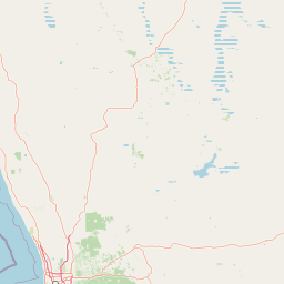
Map view of Moore River National Park

Use this park location map to pinpoint Moore River National Park in Australia, understand its exact geographic position, and read its mapped placement within the surrounding landscape more clearly.

Pigeon | © OpenStreetMap contributors

Location context for Moore River National Park

Western Australia
Recorded earthquake history

Explore the Historical Earthquake Catalogue for Moore River National Park

Access a detailed collection of recorded seismic events associated with the geography of Moore River National Park. MoriAtlas provides this historical dataset for those interested in reviewing past earthquake activity and epicentre proximity within this Western Australian protected area.

Moore River National Park Earthquake History

Catalogued events

1 event

Strongest magnitude

Magnitude 4.6

Most recent event

Dec 8, 1980

This history includes earthquakes recorded inside the park or within 50 km of its borders

Park atlas

Trace the geographic spread of protected lands and natural reserves across the Swan Coastal Plain

Compare Western Australia's Protected Landscapes: Parks Near Moore River National Park

After exploring Moore River National Park's unique banksia heathland and riparian corridor, continue your discovery of Western Australia's diverse protected areas. Compare the regional geography and ecological features of nearby national parks and natural reserves, understanding their place within the broader Swan Coastal Plain landscape.
National parkWestern Australia
38 km away#1 closest

South

Yanchep National Park: Explore Its Unique Limestone Caves and Protected Bushland Geography

Discover the subterranean formations and coastal plain landscapes.

Yanchep National Park offers a singular opportunity for atlas-driven exploration of Western Australia's natural and cultural heritage. Situated on the Swan Coastal Plain, this national park is celebrated for its extensive network of limestone caves, including the notable Crystal Cave, providing a rare glimpse into subterranean geological processes. Beyond its underground wonders, the park encompasses diverse native bushland, supporting iconic koala colonies and offering insights into the region's ecological distinctiveness. Its deep Nyoongar heritage further enriches the understanding of this mapped protected landscape.

Area
28.76 km²
Established
1957
IUCN
II
Relief
Lowland
National parkWestern Australia
51 km away#2 closest

South

Neerabup National Park: Discover its Protected Landscape and Geographic Identity in Western Australia

Explore mapped boundaries and regional context.

Neerabup National Park represents a crucial protected landscape within Western Australia, offering a distinct geographic identity for atlas-based discovery. This page focuses on its role as a national park, detailing its mapped boundaries and situating it within the rich regional geography of Western Australia. Users can explore the park's unique natural terrain and understand its contribution to the state's protected areas.

Area
9.43 km²
Established
1965
IUCN
II
Relief
Lowland
National parkWestern Australia
53 km away#3 closest

North

Badgingarra National Park: Mapped Boundaries and Protected Landscape Exploration

Explore its national park designation and regional geography.

Delve into the protected landscape identity of Badgingarra National Park, a designated national park situated in Western Australia. This entry provides detailed atlas-level information, focusing on the park's geographic scope, mapped boundaries, and its significance as a protected natural area. Understand its terrain and regional context for a deeper appreciation of Western Australia's conservation landscapes.

Area
131.08 km²
Established
1973
IUCN
II
Relief
Mixed relief
Watercolor illustration of a landscape with green rolling hills and pink clouds
National parkWestern Australia
54 km away#4 closest

Northwest

Nambul National Park: A Protected Landscape Within Western Australia's Geographic Context

Explore mapped boundaries and regional terrain context.

Nambul National Park represents a distinct protected area within the expansive geography of Western Australia. This detailed park page offers users an atlas-driven exploration of its identity as a national park, highlighting its mapped natural landscape and its regional significance. Understand the specific geographic features and protected land context that define Nambul National Park within Australia's largest state, fostering deeper geographic discovery.

Area
192.68 km²
Established
1994
IUCN
II
Relief
Upland
National parkWestern Australia
65 km away#5 closest

Southeast

Avon Valley National Park: Protected National Park Discovery in Western Australia

Explore mapped boundaries and regional landscape context.

Delve into Avon Valley National Park, a designated national park offering rich opportunities for protected-area and landscape discovery. This page serves as an atlas-style entry point, detailing the park's mapped geography and its role within the diverse natural terrain of Western Australia. Understand its specific protected landscape identity and how it contributes to the broader conservation map.

Area
43.66 km²
Established
1970
IUCN
II
Relief
Mixed relief
National parkWestern Australia
67 km away#6 closest

Southeast

Walyunga National Park: National Park Discovery in Western Australia's Geographic Landscape

Mapped boundaries and regional protected area context.

Walyunga National Park serves as a key protected area within the expansive geography of Western Australia. This detailed view focuses on its identity as a national park, offering insights into its mapped landscape and its specific role within the state's conservation network. Users can explore its protected boundaries and understand its place in the regional geography, contributing to a structured atlas of natural areas.

Area
18.14 km²
Established
1970
IUCN
II
Relief
Mixed relief
National parkWestern Australia
74 km away#7 closest

North

Watheroo National Park National Park: Mapping Protected Landscapes in Western Australia

Explore regional geography and mapped park boundaries.

Watheroo National Park represents a key protected landscape within the vast state of Western Australia. This detail page offers focused insight into the park's specific geographic character, its mapped boundaries, and its role within the regional atlas of protected areas. Understand the natural terrain and landscape context that defines this Australian national park.

Area
444.81 km²
Established
1969
IUCN
II
Relief
Upland
National parkWestern Australia
81 km away#8 closest

South

John Forrest National Park: National Park Atlas and Western Australia Protected Landscape

Mapped boundaries and regional geographic context.

Delve into the atlas-level details of John Forrest National Park, a protected area situated in Western Australia. This park's designation as a national park provides a focal point for understanding its specific geographic features and mapped extent. Users can explore its place within the broader regional geography of Western Australia, gaining structured insight into the protected landscape.

Area
26.78 km²
Established
1900
IUCN
II
Relief
Upland

Common questions about visiting, size, designation, and location context for Moore River National Park

Moore River National Park FAQs for park facts, access, geography, and protected area context

Find quick answers about Moore River National Park, including protected-area facts, park geography, trail and visitor context, and how the park fits into its surrounding country and regional landscape.
MoriAtlas Explorer

Continue Your Protected Areas Search Across the Global Atlas

Deepen your exploration by continuing the structured search for national parks and protected areas worldwide. Utilize the comprehensive filtering capabilities to compare different conservation landscapes and refine your understanding of global park geography. Discover more about the distribution and characteristics of protected natural areas.

Global natural geography