
Forests
Park geography
Examine the spatial extent, regional context, and natural landscape features of this coastal territory.
Structured Geographic Profile and Mapped Boundaries of Pembrokeshire Coast National Park
Analyze the physical geography of Pembrokeshire Coast National Park, encompassing 629 square kilometers of protected coastal terrain in the United Kingdom. This profile details the regional boundaries, spatial span, and distinct natural features such as peaks, bays, and viewpoints situated within the park environment.
Related tags
Coastal landscapesNational TrailSeabird coloniesMarine protected areaLimestone cliffs
Wales' spectacular coastal wilderness, the UK's only national park defined by its maritime landscapes
Pembrokeshire Coast National Park
Pembrokeshire Coast National Park is a remarkable protected landscape along the rugged coastline of west Wales, established in 1952 as one of Wales' three national parks. Unlike other UK national parks that feature mountainous interiors or rolling farmland, this park is distinguished by its predominantly coastal character, making it the only national park in the United Kingdom to consist largely of coastal landscapes. The park encompasses approximately 629 square kilometers of diverse terrain, including dramatic limestone cliffs, golden sandy beaches, wooded estuaries, wild inland hills, and the open moorland of the Preseli Hills. This extraordinary variety of landscapes creates a unique ecological and visual identity, with the park's geology of particular scientific interest, featuring natural arches, sea stacks, dramatic rock folding, and extensive sea caves that showcase Earth's geological history in exposed coastal sections.
- Location
- United Kingdom
- Park type
- National park
- Established
- 1952
- Area
- 629 km²
Location overview
Coastal and marine designations in Pembrokeshire, United Kingdom
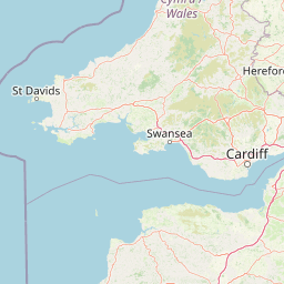
Geographic Location of Pembrokeshire Coast National Park
Pembrokeshire Coast National Park is situated within the region of Pembrokeshire in the United Kingdom. Geographic records classify the area as both a coastal park and a marine protected territory.
- Countries
- United Kingdom
- Regions
- Pembrokeshire
- Primary location
- Pembrokeshire
- Geographic setting
- Coastal · Marine
Boundary and coordinates
A 629 km² coastal outline with spatial context
Pembrokeshire Coast National Park mapped boundary and area
Pembrokeshire Coast National Park is mapped across its documented 629 km² extent. The outline gives geographic context to the coastal park while leaving exact legal limits to official records.
- Boundary area
- 607.5 km²
- Boundary perimeter
- 641.2 km
- Northernmost point
- 52.1179° N
- Southernmost point
- 51.5961° N
- Easternmost point
- 4.6322° W
- Westernmost point
- 5.3533° W
- Geographic centre
- 51.8527° N, 4.9347° W
- North–south span
- 58.1 km
- East–west span
- 49.7 km
Terrain and natural features
Explore mixed relief classifications and recorded natural landmarks
Pembrokeshire Coast National Park Terrain and Named Natural Features
Pembrokeshire Coast National Park contains mixed relief classifications across various recorded woodland, coastal, and peak environments. Linked feature cards supply specific names, types, and spatial relationships for each mapped natural formation.
Selected named natural features
Forests
Long Wood
Capes
Caldey Point
Forests
Allt y Cudyll
Natural springs
Ffynnon Beswch
Capes
First Point
Environmental setting
Temperate climate zones, mixed relief profiles, and partial forest cover categories
Pembrokeshire Coast National Park Environmental Classifications and Physical Setting
Recorded physical classifications frame the environmental setting across coastal cliffs, valleys, and islands. Stored categories connect directly to related protected areas and mapped terrain across the region.
- Relief
- Mixed relief
- Climate
- Temperate
- Water
- Major water bodies
- Forest cover
- Partial forest
- Seasonality
- Year-round
Landscape features
Cliffs · Beach · Coast · Woodland · Valleys · Hills · Islands · Lakes
Park atlas
Trace the regional context of protected areas, comparing diverse coastal and inland geographies near Pembrokeshire Coast.
Explore More National Parks and Protected Areas Around Pembrokeshire Coast National Park
Continue your protected-area discovery by exploring other national parks and significant landscapes located in the broader region surrounding Pembrokeshire Coast National Park. Compare diverse coastal terrain, inland hills, and marine protected zones to gain richer geographic context and understand connected conservation efforts.
National parkWales
46 km away#1 closest
East

Brecon Beacons National Park: Explore Wales' Iconic Protected Mountain Landscape
Discover mapped terrain, park boundaries, and regional geography.
Brecon Beacons National Park, officially Bannau Brycheiniog, stands as a premier protected area within Wales, covering over 1,344 square kilometers of striking mountainous terrain. This national park is defined by its dramatic Old Red Sandstone ranges, including Pen y Fan, South Wales' highest peak, and features diverse landscapes from heather moorland to extensive river valleys. Its mapped boundaries encompass unique geological features, significant historical sites, and provide context for regional geographic exploration, making it a key destination for understanding protected lands in the UK.
- Area
- 1,344 km²
- Established
- 1957
- IUCN
- V
- Visitors
- 4.4M annual
Biosphere reserveWales
About 53 km away#2 closest
Northeast
Dyfi Biosphere: Mapped Protected Landscapes and Coastal Geography in Western Wales
Discover the estuarine wetlands, raised mires, and Atlantic woodlands of a key Welsh biosphere reserve
The Dyfi Biosphere provides a comprehensive look at the geography of a protected coastal region in Wales. Its boundaries encompass diverse terrain ranging from the Ynyslas sand spit and salt marshes to the primary raised mire of Cors Fochno. This landscape functions as a vital wetland system, offering a clear visual representation of dune succession, peatland growth, and temperate Atlantic woodland ecosystems within a single, interconnected, and carefully monitored geographic area.
- Area
- 15.89 km²
- Established
- 1977
- Relief
- Mixed relief
- Climate
- Temperate
Biosphere reserveDevon
About 64 km away#3 closest
Southeast
North Devon's Biosphere Reserve: Protected Landscapes and Geographic Map Exploration
Coastal dunes, estuaries, and marine habitats in North Devon
An extensive overview of North Devon's Biosphere Reserve, highlighting its role as a protected landscape in South West England. Analyze the distribution of its diverse terrain, including Britain's largest sand dune system, river catchments, and offshore coral reefs, through detailed geographic and habitat mapping.
- Area
- 5,262 km²
- Established
- 1976
- Visitors
- 4M annual
- Relief
- Lowland
National parkWales
64 km away#4 closest
Northeast
Snowdonia National Park: Protected Landscape and Map Exploration in North Wales
Mountain terrain, glacial lakes, and regional geography.
Snowdonia National Park offers a profound exploration of mountainous protected landscapes in North Wales. This page details the park's mapped boundaries, revealing a terrain shaped by glaciation, featuring dramatic peaks like Snowdon, steep valleys, and pristine glacial lakes. Understand its geographic identity within the United Kingdom and how its protected status contributes to the regional landscape context, providing a unique focus for atlas-based discovery.
- Area
- 2,142 km²
- Established
- 1951
- IUCN
- V
- Relief
- Mountain

National parkUnited Kingdom
65 km away#5 closest
Southeast
Exmoor National Park: A Premier Protected Landscape in South West England for Atlas Exploration
Mapped terrain, moorland, and dramatic coastal geography.
Discover Exmoor National Park, a vast protected area in South West England celebrated for its sweeping heather moorland, dramatic coastline with the highest sea cliffs on mainland Britain, and deep, ancient wooded valleys. This national park offers a unique landscape for atlas-based exploration, revealing its distinct geography, mapped boundaries, and rich terrain shaped by centuries of natural processes and human activity.
- Area
- 692 km²
- Established
- 1954
- IUCN
- V
- Visitors
- 1.4M annual
National parkDevon
110 km away#6 closest
Southeast
Dartmoor National Park: Granite Tors and Prehistoric Landscape in Devon
Mapped protected area with significant Bronze Age remains.
Dartmoor National Park represents a distinctive granite upland in Devon, England, characterized by its dramatic tors and expansive moorland. This protected landscape is globally significant for its dense concentration of prehistoric archaeological sites, including stone circles, standing stones, and ancient settlements. Exploring Dartmoor offers a unique insight into Britain's regional geography, mapped terrain, and enduring connection to ancient human history.
- Area
- 954 km²
- Established
- 1951
- IUCN
- V
- Visitors
- 11M annual

Protected areaCornwall
About 133 km away#7 closest
South
River Gannel Protected Area: Cornwall Coastal Estuary and Marine Conservation Zone
Mapped tidal channels and coastal landscape geography in Cornwall
River Gannel provides a focal point for understanding the tidal geography of northern Cornwall. From its inland source to the dynamic estuary separating Newquay and Crantock, the area features protected marine habitats, sand dunes, and deep-rooted industrial heritage. This record details the physical boundaries and ecological significance of this coastal landscape as it drains into the Celtic Sea.
- Established
- 2016
- Relief
- Lowland
- Climate
- Temperate
- Access
- Easy access
Protected landscapeSomerset
133 km away#8 closest
Southeast
Somerset Levels Protected Landscape: Geographic Mapping and Wetland Terrain Analysis
A low-lying coastal plain and historic wetland basin in Somerset
Examine the distinct topography of the Somerset Levels, where flat horizons, pollarded willows, and ancient drainage channels create a unique English landscape. This protected area offers deep insight into prehistoric archaeology, including preserved Neolithic trackways, alongside modern wetland conservation of international significance within a rural basin.
- Area
- 650 km²
- Established
- 1997
- Relief
- Lowland
- Climate
- Temperate
MoriAtlas Explorer
Continue Exploring Pembrokeshire Coast National Park's Geographic and Landscape Context
Venture deeper into the mapped terrain and protected area atlas of Pembrokeshire Coast National Park. Understanding its specific geographic setting and landscape character enriches your appreciation of this significant Welsh protected area. Discover how its unique coastal geology and regional placement contribute to the broader conservation map, offering a structured view for geographic exploration.
Browse next
Global natural geography
Explore related park routes
Explore MoriAtlas Global ParksBrowse All MoriAtlas ParksGlobal Park Map DiscoveryMoriAtlas: Browse All CountriesBrowse All MoriAtlas ContinentsNational Park Environment AtlasGrand Canyon National Park AtlasYellowstone National Park AtlasYosemite National Park Atlas and GeographySerengeti National Park AtlasGalápagos National Park Protected LandscapeBanff National Park Geography and AtlasKruger National Park Atlas EntryUluṟu-Kata Tjuṯa National Park AtlasExplore Uluru-Kata Tjuta National Park GeographyPlitvice Lakes National Park AtlasFiordland National Park Protected LandscapeGreat Smoky Mountains National Park AtlasAfghanistan National Parks and Protected AreasAlbania National Parks and Protected AreasAlgeria National Parks and Protected AreasAmerican Samoa National Parks and Protected AreasAndorra National Parks and Protected AreasAngola National Parks and Protected AreasAntarctica National Parks and Protected AreasAntigua and Barbuda Park List