Mori Atlas logo
National parkRokua National Park

Discover mapped esker formations, ancient pine forests, and unique kettle lakes within this protected landscape.

Rokua National Park: A UNESCO Global Geopark of Glacial Heritage in Northern Ostrobothnia

(Rokuan kansallispuisto)

Rokua National Park, designated a UNESCO Global Geopark, stands as a testament to Finland's glacial past within the Northern Ostrobothnia region. This protected landscape showcases an exceptional display of Quaternary landforms, including Finland's deepest kettle hole, Syvyydenkaivo, and sprawling esker ridges. Explore the unique geography of this park, characterized by its nutrient-poor soils supporting ancient pine forests and distinctive heathlands, all meticulously mapped and contextualized within the broader regional geography of Northern Ostrobothnia.

UNESCO Global GeoparkBoreal forestGlacial landformsKettle lakesEsker formationNorthern Finland
Stylized illustration of a lake reflecting mountains and trees with a winding path

Rokua National Park

National park

Park overview

Structured park overview, official facts, and landscape profile for Rokua National Park

Rokua National Park park facts, protected area profile, and essential visitor context
Review the core facts for Rokua National Park, including designation, size, terrain, visitor scale, habitats, and operating context in one park-focused overview.

About Rokua National Park

Rokua National Park occupies a distinctive position in Finland's protected area network as both a nature conservation site and a UNESCO Global Geopark. The park's core protection value centers on the Rokuanvaara esker formation, a massive glacial deposit that stretches from the eastern Finnish border near Ilomantsi to the island of Hailuoto off the coast of Oulu. The park encompasses the most valuable portion of this formation, protecting a complex landscape of ridges, hollows, and kettle lakes shaped by retreating glacial ice around 10,000 years ago. The terrain varies from sandy esker crests to marshy depressions, creating diverse microhabitats within a relatively compact area. The park lies between the cities of Oulu and Kajaani, making it accessible for day visitors while maintaining its wild character. Management by Metsähallitus ensures sustainable recreation while preserving the park's natural and geological values for future generations.

Quick facts and research context for Rokua National Park

Rokua National Park covers approximately 8.8 square kilometers of protected terrain in northern Finland. The park lies on the southern flank of Rokuanvaara Hill, a prominent esker formation created during the final stages of the last Ice Age. The area forms part of the broader Rokua UNESCO Global Geopark, which also encompasses the Oulu River Valley and Lake Oulu regions. The park is managed by Metsähallitus and receives approximately 50,700 visitors annually. The landscape features a remarkable concentration of glacial landforms including terminal moraines, kame terraces, and numerous kettle lakes, making it one of Finland's most geologically significant protected areas.

Park context

Deeper park guide and search-rich context for Rokua National Park

Rokua National Park history, landscape, wildlife, and travel context
Explore Rokua National Park through its history, landscape character, ecosystems, wildlife, conservation priorities, cultural context, and seasonal travel timing in a structured park guide built for atlas discovery and search intent.

Why Rokua National Park stands out

Rokua National Park is best known for its extraordinary geological heritage and well-preserved glacial landscape. The park protects one of Finland's most complete displays of Quaternary landforms, including the deepest kettle hole in the country at Syvyydenkaivo. The old-growth pine forests growing on the nutrient-poor esker soils represent some of the most natural forest ecosystems in southern Finnish Lapland. The park's designation as a UNESCO Global Geopark recognizes its international significance for understanding glacial history and post-glacial development. Visitors come to explore the network of kettle lakes, esker ridges, and dune formations that characterize this unique landscape.

A calm lake reflecting the sky and trees, bordered by a grassy shoreline and dense pine forest
Pitkäjärvi lake surrounded by pine forests in Rokua National Park

Rokua National Park history and protected-area timeline

Rokua National Park was established in 1956 to protect the valuable natural types and terrain features of the Rokuanvaara esker formation. The creation of the park reflected growing post-war recognition in Finland of the need to preserve distinctive geological formations and natural landscapes. The park's boundary was drawn to encompass the most significant glacial landforms and the remaining patches of old-growth forest. Over the decades, the park's role has evolved from a primarily conservation-focused protected area to a broader educational and geotourism destination. The establishment of the UNESCO Global Geopark designation brought additional recognition and resources for interpreting the site's geological significance. Today, the park serves multiple functions: ecosystem protection, geological education, and sustainable outdoor recreation. The three municipalities of Vaala, Muhos, and Utajärvi collaborate with Metsähallitus to develop tourism infrastructure while maintaining conservation priorities.

Rokua National Park landscape and geographic character

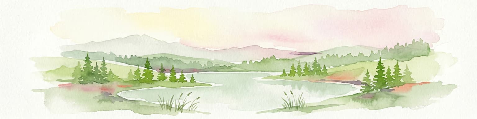
The physical landscape of Rokua National Park is dominated by the Rokuanvaara esker formation, a long ridge of sorted sand and gravel deposited by glacial meltwater streams during the final phase of the last Ice Age. The terrain rises sharply from the surrounding wetlands, with the esker crest providing well-drained ground for pine forests. Within the park, the landscape displays remarkable diversity: smooth esker slopes give way to steep kettle hole depressions, and sand dunes alternate with marshy hollows and clear kettle lakes. The glacial landform assemblage includes terminal moraines marking the ice front's maximum extent, hummocky moraines recording the uneven retreat, and numerous eskers tracing former meltwater channels. Post-glacial processes have added further complexity: wind-formed dunes overlay portions of the esker, while peat bogs have developed in waterlogged depressions. The seasonal contrast is pronounced—snow cover transforms the landscape in winter, while summer reveals the full detail of ridges, heathlands, and the chain of kettle lakes known as suppalammet.

Rokua National Park ecosystems, habitats, and plant life

The nature of Rokua National Park reflects the harsh conditions created by the nutrient-poor sandy soils and the northern continental climate. The vegetation is dominated by pine forests, with some spruce occurring in moister depressions. The forest understory is sparse, consisting mainly of lichens and ericaceous shrubs such as blueberry and lingonberry—the classic heathland vegetation of boreal Finland. The open heathlands on the drier esker slopes are particularly characteristic, with a carpet of lichens giving the ground a grayish-green appearance even in winter. The numerous kettle lakes and peat bogs add aquatic and wetland habitats to the park's ecological diversity. These water bodies range from small, groundwater-fed kettle holes to larger lakes with well-developed shoreline vegetation. The park lies within the southern boreal forest zone, and while the forest is not old-growth in the strictest sense, many areas retain a natural structure with fallen logs and dead wood providing habitat for fungi and invertebrates.

Rokua National Park wildlife and species highlights

The wildlife of Rokua National Park reflects the boreal forest ecosystem characteristic of northern Finland. The pine forests support populations of squirrels, various tit species, and woodpeckers, while the kettle lakes provide habitat for waterfowl including goldeneye and teal. The area's position along migratory routes brings seasonal bird activity, with passage migrants using the lakes as resting spots. The dead wood in the forests provides important habitat for fungi and invertebrates that form the base of the forest food web. Larger mammals present in the broader region, such as moose, may occasionally use the park area. The clear kettle lakes support fish populations that attract fishing visitors. The combination of forest, wetland, and lake habitats creates a relatively diverse wildlife community within the constraints of the northern Finnish environment.

Rokua National Park conservation status and protection priorities

Rokua National Park's conservation significance derives from its combination of geological and biological values. As a UNESCO Global Geopark, the site is recognized internationally for its educational value in explaining glacial processes and landscape evolution. The protection of the Rokuanvaara esker formation preserves a type locality for several glacial landforms, including the remarkable Syvyydenkaivo kettle hole. The old-growth pine forests, though limited in extent, represent some of the more natural forest examples in the region and serve as reference areas for ecological research. The park's inclusion in broader geopark initiatives connects it to regional conservation efforts encompassing the Oulu River Valley and Lake Oulu areas. The management approach balances visitor access with protection of the geological and ecological values that make the area distinctive.

Rokua National Park cultural meaning and human context

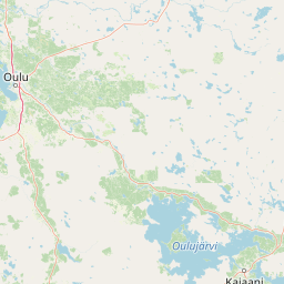
The Rokua area holds cultural significance within the broader context of northern Finnish history and heritage. The esker formation has been a landmark in the landscape for millennia, and the area lies within a region with strong connections to Finnish cultural history. The three municipalities surrounding the park—Vaala, Muhos, and Utajärvi—have developed collaborative approaches to tourism development that reflect regional identity. The nearby Ahmas village contains a traditional Finnish heritage area, while the region more broadly reflects the settlement patterns of Finnish eastern cultures. The park lies between two major regional centers, Oulu and Kajaani, placing it within a cultural landscape shaped by both coastal and interior Finnish traditions.

Top sights and standout views in Rokua National Park

The standout features of Rokua National Park include the exceptional concentration of glacial landforms, the old-growth pine forests, and the UNESCO Global Geopark designation. Syvyydenkaivo, at over 50 meters deep, is the deepest kettle hole in Finland and represents a unique geological feature. The network of kettle lakes known as suppalammet creates a distinctive chain of water bodies within the esker terrain. The park offers approximately 60 kilometers of marked hiking trails and 70 kilometers of ski trails, providing extensive opportunities for exploration. The Rokua Health & Spa hotel and other nearby accommodation support visitor access, while the Suppa outdoor center provides orientation and interpretation services.

Best time to visit Rokua National Park

The best time to visit Rokua National Park depends on the type of experience sought. Summer months offer the most accessible trail conditions and the opportunity to see the full detail of the heathland vegetation and kettle lake landscapes. The long northern days of June and July provide extended opportunities for hiking, while August brings the mushroom and berry season. Winter offers a different experience entirely, with cross-country skiing on the extensive trail network. The park's northern location means that winter snow cover is reliable from December through March. Spring and autumn are transitional seasons that can offer good conditions with fewer visitors, though trail conditions may be less predictable.

Park location guide

Geography guide, regional context, and park location map for Rokua National Park

Rokua National Park park geography, regions, and map view in Finland
Understand where Rokua National Park sits in Finland through a broader geographic reading of the surrounding landscape, nearby location context, and its mapped position within the national park landscape.

How Rokua National Park fits into Finland

Finland, officially the Republic of Finland, is a Nordic country in Northern Europe with a population of 5.6 million. It borders Sweden, Norway, and Russia, with the Gulf of Bothnia to the west and the Gulf of Finland to the south. The country gained independence from Russia in 1917 and is a unitary parliamentary republic. Its landscape is characterized by extensive boreal forests and over 180,000 lakes.

Wider geography shaping Rokua National Park in Finland

Finland is located in Northern Europe, occupying a peninsula bordered by the Gulf of Bothnia to the west and the Gulf of Finland to the south. It shares land borders with Sweden to the northwest, Norway to the north, and Russia to the east. The terrain is predominantly flat with extensive forest coverage and numerous lakes.

Map view of Rokua National Park

Use this park location map to pinpoint Rokua National Park in Finland, understand its exact geographic position, and read its mapped placement within the surrounding landscape more clearly.

Pigeon | © OpenStreetMap contributors

Location context for Rokua National Park

Northern Ostrobothnia

Discover the distinct protected-area character through imagery of esker formations, deep kettle holes, and old-growth pine habitats.

Rokua National Park Photos: Visual Guide to Finland's Glacial Landscapes and Boreal Forests
Browse a curated collection of photos and images showcasing the unique natural beauty of Rokua National Park, a UNESCO Global Geopark. These visuals illuminate the distinctive glacial landforms, such as eskers and kettle holes, along with the pristine old-growth pine forests and lichen-covered heathlands that define this protected landscape in Northern Finland.

A calm lake reflecting the sky and trees, bordered by a grassy shoreline and dense pine forest

Park atlas

Trace the glacial landforms and old-growth forests of Northern Ostrobothnia and beyond

Continue Your Discovery: Other National Parks and Protected Areas Near Rokua National Park
Expand your exploration beyond Rokua National Park to an atlas of other national parks and protected areas in Finland, comparing glacial landforms and boreal forest ecosystems. Discover how diverse conservation landscapes connect regionally, trace their geographic distribution, and gain broader context on Finland's protected natural heritage.
Watercolor painting of a lake surrounded by forests with mountains in the background and a sunset sky
National parkFinland

Tiilikkajärvi National Park: Finland's Unique Protected Landscape with Sandy Shores and Eskers

Mapped geography of a distinctive Finnish national park.

Tiilikkajärvi National Park showcases a unique combination of natural features within Finland's protected lands. The park's core is the Tiilikkajärvi lake, almost entirely encircled by expansive sandy beaches and dramatic esker peninsulas. These glacial landforms create a striking visual contrast with the surrounding boreal forests and rare undrained aapa bogs. Explore the mapped landscape context and protected area identity of this significant Finnish natural environment.

Area
72 km²
Established
1982
IUCN
II
Visitors
26.1K annual
National parkKainuu

Hiidenportti National Park: Kainuu Protected Area and Geographic Landscape Context

Explore mapped boundaries and regional geography in eastern Finland.

This MoriAtlas entry details Hiidenportti National Park, a designated national park situated in the Kainuu region of Finland. It serves as a vital hub for understanding the protected area's mapped landscape, its specific geographic characteristics, and its position within the regional atlas of eastern Finland's natural terrain. Dive into the structured details that define Hiidenportti National Park's protected identity and its contribution to the geographic understanding of the taiga-forested regions.

Area
45 km²
Established
1982
IUCN
II
Visitors
11.3K annual
Watercolor landscape featuring green hills, pine trees, and a yellowish field
National parkFinland

Syöte National Park: Mapped Protected Landscape and Fell Geography in Finland

Explore Finland's southernmost fell and diverse northern wilderness.

Delve into the protected territory of Syöte National Park, a key national park in northern Finland. This page highlights the park's distinct geographic features, including its southernmost fell, Iso-Syöte, alongside expansive mire systems and old-growth boreal forests. Understand the mapped boundaries and the unique ecological transition zone it represents within the Finnish atlas, offering a comprehensive view of its landscape context and protected area status.

Area
299 km²
Established
2000
IUCN
II
Visitors
88.2K annual
National parkLapland

Bothnian Bay National Park: A National Park in Lapland's Geographic Atlas

Protected landscape and mapped terrain in northern Finland.

Delve into Bothnian Bay National Park, a key protected area situated in the Lapland region of Finland. This page serves as an atlas gateway to understanding the park's specific geographic features, its mapped boundaries as a national park, and its role within the broader context of Finland's protected natural landscapes.

Area
157 km²
Established
1991
IUCN
II
Visitors
6.3K annual
National parkFinland

Salamajärvi National Park: Explore Finland's Premier Mired Wilderness and Protected Landscape

Mapped boundaries and wetland ecosystems of this Finnish National Park.

Salamajärvi National Park is a critical protected area in Finland, celebrated for its unparalleled mire ecosystems, which represent some of the country's most extensive and intact peatland environments. The park's landscape is shaped by the Suomenselkä watershed, featuring a mosaic of old-growth forests, forest lakes, and rugged terrain, providing a vital sanctuary for forest reindeer. MoriAtlas details its geographic context and protected landscape features, offering users a structured way to explore its natural identity and mapped boundaries within Finland.

Area
62 km²
Established
1982
IUCN
II
Visitors
24.5K annual
National parkNorrbotten County

Haparanda Archipelago National Park: A Northern Baltic Coastal Protected Landscape

Explore emergent islands, sand dunes, and unique coastal geography.

Haparanda Archipelago National Park in Norrbotten County is a distinctive protected landscape characterized by its recent geological emergence and unusual sand dune formations along the northern Baltic coast. This national park offers a unique perspective on coastal geography, with islands steadily rising from the sea. MoriAtlas users can explore its mapped boundaries, understand its dynamic terrain, and appreciate its role as a significant protected area within Sweden's unique archipelagic environments.

Area
60 km²
Established
1995
IUCN
II
Relief
Lowland
National parkFinland

Hossa National Park: Detailed National Park and Protected Landscape Geography

Explore mapped boundaries and regional context within Finland.

Delve into the protected landscape of Hossa National Park, a designated national park in Finland. This page provides structured geographic information, focusing on its mapped boundaries and position within the country's natural terrain. Understand how Hossa National Park contributes to the atlas of protected areas in Northern Europe, offering insights into its specific landscape character and regional significance for geographic discovery.

Established
2017
Scope
Terrestrial
National parkRepublic of Karelia

Kalevalsky National Park: Rare Old-Growth Boreal Forest and Kalevala Epic Landscape

Mapped protected wilderness in the Republic of Karelia

Kalevalsky National Park is a significant protected area within the Republic of Karelia, Russia, safeguarding one of Europe's last remaining old-growth boreal pine forests. This vast national park protects a landscape characterized by numerous lakes, rivers, and marshes resting on ancient Baltic Shield bedrock, offering a clear representation of primeval taiga ecosystems. Its profound cultural ties to the Kalevala epic, Finland's national poem, make it a unique destination for exploring both natural and mythological geography. Understand the park's mapped boundaries and its place within the regional context.

Area
744 km²
Established
2007
IUCN
II
Relief
Lowland

Common questions about visiting, size, designation, and location context for Rokua National Park

Rokua National Park FAQs for park facts, access, geography, and protected area context
Find quick answers about Rokua National Park, including protected-area facts, park geography, trail and visitor context, and how the park fits into its surrounding country and regional landscape.
MoriAtlas Explorer

Continue Your Protected Areas Search Across the Global Atlas

Deepen your exploration by continuing the structured search for national parks and protected areas worldwide. Utilize the comprehensive filtering capabilities to compare different conservation landscapes and refine your understanding of global park geography. Discover more about the distribution and characteristics of protected natural areas.

Global natural geography