
Rivers
Park geography
Explore recorded elevations, mountain topography, and boreal landscape characteristics
Comprehensive Geographic Profile and Mapped Boundaries of Rondane National Park in Innlandet
Rondane National Park spans a recorded area of 963 square kilometers within the Innlandet region of Norway. This structured profile maps the park terrain, including a significant mountain elevation range from 1000 meters to the 2178 meter peak of the highest recorded point. Gain insight into regional geography, habitat types, and physical features like plateaus and ridges located within the protected boundary.
Norway's oldest national park protecting wild reindeer and alpine peaks
Rondane National Park
Rondane National Park is Norway's oldest national park, established on 21 December 1962 to protect a pristine high-mountain landscape in central southern Norway. The park spans 963 square kilometers across Innlandet county, encompassing dramatic alpine plateaus, ten peaks exceeding 2,000 meters in elevation, and the iconic Rondeslottet mountain reaching 2,178 meters. The park serves as one of the most significant conservation areas in Scandinavia, protecting one of the few remaining populations of wild reindeer in Europe. Visitors encounter a landscape shaped by glacial activity during the last ice age, characterized by deep valleys, kettle holes, eskers, and the central lake Rondvatnet. The aridity of the region, combined with nutrient-poor soils, creates a distinctive ecosystem where lichen and heather dominate the higher elevations while birch forest occupies the lower valleys.
- Location
- Norway
- Park type
- National park
- Established
- 1962
- Area
- 963 km²
- Highest point
- 2,178 m
Location overview
Regional placement within Innlandet and Norwegian geographic status
Geographic Positioning of Rondane National Park in Norway
Rondane National Park is officially situated within the Innlandet region of mainland Norway. The protected landscape remains entirely inland, featuring no marine, coastal, or transboundary designations.
- Countries
- Norway
- Regions
- Innlandet
- Primary location
- Innlandet
- Geographic setting
- Inland
Boundary and coordinates
Interactive protected-area geometry and calculated spatial measurements
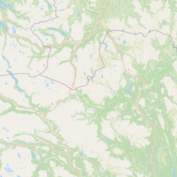
Rondane National Park Boundary Map and Spatial Extent
Mapped boundary geometry delivers immediate spatial context for the protected landscape. Accompanying measurements supply surface area, coordinate limits, and geographic spans for detailed analysis.
- Boundary area
- 968 km²
- Boundary perimeter
- 223.9 km
- Northernmost point
- 62.0856° N
- Southernmost point
- 61.6899° N
- Easternmost point
- 10.1951° E
- Westernmost point
- 9.3788° E
- Geographic centre
- 61.9016° N, 9.813° E
- North–south span
- 44.1 km
- East–west span
- 42.9 km
Elevation and terrain
Explore recorded vertical relief and named physical features within the park
Rondane National Park Elevation Range and Mountain Terrain Geography
Review the stored elevation summary detailing the mountain relief metrics across the protected landscape. Examine individual cards providing feature names, types, and spatial relationships recorded within the terrain.
- Minimum elevation
- 1,000 m
- Maximum elevation
- 2,178 m
- Highest point
- 2,178 m
Selected named natural features
Hills
Tverrhøgda
1,160 m
Hills
Nørdre Geitsida
Valleys
Haverdalen
Hills
Stygghøin NØ2
1,727 m
Hills
Geithaugane
Environmental setting
Analysis of mountain relief, boreal climate zones, and upland habitats
Rondane National Park Environmental Settings and Physical Classification Profile
Recorded landscape features, habitat types, and relief metrics serve as complementary frameworks for examining the physical setting of Rondane National Park. Stored environmental categories connect directly to related atlas destinations and geographic records across the protected terrain.
- Relief
- Mountain
- Climate
- Boreal
- Water
- Minor water
- Forest cover
- Sparse forest
- Seasonality
- Year-round
Landscape features
Mountains · Plateau · Valleys · Lakes
Habitat types
Temperate broadleaf forest · Heath · Tundra habitat
Park atlas
Trace the mapped geography and compare other protected areas within Norway's high-mountain regions.
Discover Adjacent National Parks and Protected Areas Near Rondane National Park
Browse other national parks and protected areas in Norway, focusing on nearby destinations and similar high-mountain landscapes surrounding Rondane National Park. Compare distinct park characteristics, trace regional conservation efforts, and understand the broader geographic context of Scandinavia's protected wild reindeer habitats.
National parkInnlandet
About 2.5 km away#1 closest
North

Dovre National Park: Mapped Alpine Terrain & Protected Reindeer Habitat in Innlandet
Norway's protected mountain plateau landscape and wildlife corridor.
Dovre National Park is a significant protected area in Innlandet, Norway, characterized by its expansive alpine plateau terrain and role as a vital ecological corridor for wild reindeer. This national park offers users an atlas-level view of its mapped natural boundaries, focusing on the unique subarctic mountain landscape and its conservation importance. Understand Dovre National Park's geographic identity and its contribution to a contiguous network of protected lands.
- Area
- 289 km²
- Established
- 2003
- IUCN
- II
- Relief
- Mountain
Protected landscapeInnlandet
About 12 km away#2 closest
North
Fokstugu landskapsvernområde: Alpine Protected Landscape and Regional Ecological Corridor
A vital bridge for mountain migration in Innlandet, Norway.
Fokstugu landskapsvernområde protects a unique mix of alpine terrain, geological formations, and cultural mountain heritage across the Dovrefjell plateau. Serving as a connective corridor between major national parks, this protected area maintains essential migratory paths for wild reindeer and preserves traditional Norwegian upland farming features.
- Area
- 72.3 km²
- Established
- 2002
- Relief
- Mountain
- Climate
- Alpine
National parkInnlandet
16 km away#3 closest
North
Dovrefjell, Sunndalsfjella National Park: Mapping Norway's Largest Alpine Protected Landscape
Explore its protected boundaries, mountain terrain, and unique ecological significance.
Dovrefjell, Sunndalsfjella National Park is a cornerstone of Norwegian protected areas, offering an expansive alpine wilderness with dramatic mountain scenery. This page details the park's geographic context, mapped landscape features, and its importance as a refuge for unique wildlife like wild reindeer and muskox. Users can investigate the park's protected boundaries and understand its role within the regional geography of Innlandet, contributing to a structured atlas of Scandinavia's natural heritage.
- Area
- 1,693 km²
- Established
- 2002
- IUCN
- II
- Relief
- Mountain
National parkNorway
41 km away#4 closest
Southwest
Jotunheimen National Park: Norway's Iconic Alpine Protected Landscape and Geographic Core
Explore mapped glacial terrain and alpine geography.
Jotunheimen National Park stands as a monument to Norway's alpine grandeur, protecting over 1,151 square kilometers of spectacular mountainous terrain. This protected area is defined by its dramatic glacial features, including sharp peaks exceeding 1,900 meters, U-shaped valleys, and pristine alpine lakes, making it a significant focus for geographic exploration and mapped landscape study. Delve into the core of Norway's mountain heartland, understanding the mapped boundaries and regional geological context that shape this iconic protected landscape.
- Area
- 1,151 km²
- Established
- 1980
- IUCN
- II
- Relief
- Mountain
National parkNorway
58 km away#5 closest
Northeast
Forollhogna National Park: Norway's Gently Rolling Alpine Protected Landscape Atlas
Explore unique terrain and vital wild reindeer habitat in Central Norway.
MoriAtlas provides structured geographic context for Forollhogna National Park, Norway's nineteenth national park. This area is best known for its distinctively gentle, rolling alpine terrain, a contrast to other Norwegian mountain ranges, and as a critical habitat for wild reindeer. Discover the park's unique landscape character, its role as a protected area, and the ongoing cultural traditions tied to its mountain pastures, all visualized within a comprehensive atlas framework.
- Area
- 1,062 km²
- Established
- 2001
- IUCN
- II
- Relief
- Mountain
National parkInnlandet
About 62 km away#6 closest
South
Langsua National Park: Protected Mountain Forests and Inland Wilderness in Innlandet, Norway
Discover mapped boundaries and regional geographic context.
Langsua National Park, a designation expanded in 2011, is a prominent protected area in Norway's Innlandet county. This national park encompasses 537.1 square kilometers of diverse mountainous terrain, characterized by extensive mountain forests and inland wilderness habitats. Its creation consolidates fragmented nature reserves into a significant contiguous protected landscape, offering valuable insight into Norway's conservation strategies and the geographic context of its eastern mountain regions.
- Area
- 537.1 km²
- Established
- 2011
- IUCN
- II
- Relief
- Mixed relief
National parkInnlandet
About 66 km away#7 closest
Northwest
Reinheimen National Park: Norway's Vast Protected Wilderness Landscape and Alpine Geography
Map of protected boundaries and diverse mountain terrain.
Reinheimen National Park is a cornerstone of Norway's protected areas, encompassing a substantial portion of Western Norway's alpine wilderness. This national park protects a dynamic landscape characterized by dramatic western peaks and gentler eastern plateaus, providing critical habitat for wild reindeer and other wildlife. Its extensive mapped boundaries and varied natural terrain offer a rich subject for geographic discovery and atlas exploration, highlighting the ecological significance of well-preserved mountain ecosystems within Innlandet.
- Area
- 1,969 km²
- Established
- 2006
- IUCN
- II
- Relief
- Mountain
National parkVestland
103 km away#8 closest
West
Jostedalsbreen National Park: Europe's Premier Glacial Protected Landscape
Mapped terrain and protected area discovery in Vestland, Norway.
Jostedalsbreen National Park represents a unique geographic entity, safeguarding the largest glacier on the European mainland. This national park, situated in Norway's Vestland region, offers profound insights into glacial landscapes and mountain geography. Users can explore the vast ice mass that dominates the terrain, observe the U-shaped valleys carved by its movement, and understand the geological processes shaping this dynamic environment. The park's protected status highlights its importance for understanding glacial science and preserving a critical component of Norway's natural heritage.
- Area
- 1,310 km²
- Established
- 1991
- IUCN
- II
- Relief
- Mountain
MoriAtlas Explorer
Continue exploring Rondane National Park's distinctive mapped geography and protected landscape.
Delve deeper into the geographic context and protected area specifics of Rondane National Park. Understanding its unique alpine terrain, glacial formations, and position within Innlandet county provides essential insight into Scandinavian wilderness. MoriAtlas facilitates a structured exploration of this historic national park, revealing its mapped boundaries and ecological importance.
Browse next
Global natural geography
Explore related park routes
Explore MoriAtlas Global ParksBrowse All MoriAtlas ParksGlobal Park Map DiscoveryMoriAtlas: Browse All CountriesBrowse All MoriAtlas ContinentsNational Park Environment AtlasGrand Canyon National Park AtlasYellowstone National Park AtlasYosemite National Park Atlas and GeographySerengeti National Park AtlasGalápagos National Park Protected LandscapeBanff National Park Geography and AtlasKruger National Park Atlas EntryUluṟu-Kata Tjuṯa National Park AtlasExplore Uluru-Kata Tjuta National Park GeographyPlitvice Lakes National Park AtlasFiordland National Park Protected LandscapeGreat Smoky Mountains National Park AtlasAfghanistan National Parks and Protected AreasAlbania National Parks and Protected AreasAlgeria National Parks and Protected AreasAmerican Samoa National Parks and Protected AreasAndorra National Parks and Protected AreasAngola National Parks and Protected AreasAntarctica National Parks and Protected AreasAntigua and Barbuda Park List