Mori Atlas logo
National parkSaklıkent National Park

Discover the geography, mapped boundaries, and geological formations of this dramatic protected area in Muğla Province.

Saklıkent National Park: Turkey's Deepest Limestone Gorge and Protected Natural Landscape

(Saklıkent Milli Parkı)

Saklıkent National Park is a premier protected area in southwestern Turkey, defined by its spectacular 18-kilometer limestone canyon. This natural wonder, carved by the Karaçay stream within the Taurus Mountains, offers a profound glimpse into geological processes and protected landscape dynamics. Users can explore the park's mapped boundaries, understand its significant karstic features, and appreciate its role within the regional geography of Muğla Province.

CanyonLimestone formationsNational parkTaurus MountainsKarst landscapeMediterranean forest
Illustration of a deep canyon with waterfall, rocky cliffs, green trees, river, and bridge under pink sky

Saklıkent National Park

National park

Park overview

Structured park overview, official facts, and landscape profile for Saklıkent National Park

Saklıkent National Park park facts, protected area profile, and essential visitor context
Review the core facts for Saklıkent National Park, including designation, size, terrain, visitor scale, habitats, and operating context in one park-focused overview.

About Saklıkent National Park

Saklıkent National Park protects a magnificent canyon system where the Karaçay stream has carved an extraordinary passage through limestone terrain of the Taurus Mountains over thousands of years. The gorge represents a geomorphological phenomenon of significant scientific and aesthetic value, with its steep walls, hidden waterfalls, and ever-changing water conditions creating a dynamic natural environment. The protected area encompasses not only the dramatic gorge itself but also the surrounding landscape of Mediterranean forests, alpine meadows, and traditional highland settlements that characterize this region of southwestern Turkey. The park serves as an important ecological corridor and habitat for species adapted to the canyon environment and its adjacent forests. Visitors to Saklıkent experience a unique combination of natural wonder and adventure, with the canyon offering different levels of accessibility depending on season and physical capability, from short walks along the initial accessible sections to advanced technical descents for experienced canyoners.

Quick facts and research context for Saklıkent National Park

Saklıkent National Park is located in the Taurus Mountains of southwestern Turkey, approximately 50 kilometers from Fethiye and within the Seydikemer district of Muğla Province. The canyon was established as a national park in 1996 and spans 1,643 hectares, though the broader protected area encompasses nearly 12,390 hectares including surrounding villages. The gorge reaches depths of 300 meters and extends 18 kilometers in length, with its narrowest points dropping to just 2 meters across. The Karaçay stream, fed by cold karstic springs, flows through the canyon with a discharge of 14-17 cubic meters per second at the canyon exit. The surrounding landscape features a transition from Mediterranean maki vegetation at lower elevations to coniferous forests of red pine, black pine, and historic cedar stands at higher altitudes above 1,000 meters.

Park context

Deeper park guide and search-rich context for Saklıkent National Park

Saklıkent National Park history, landscape, wildlife, and travel context
Explore Saklıkent National Park through its history, landscape character, ecosystems, wildlife, conservation priorities, cultural context, and seasonal travel timing in a structured park guide built for atlas discovery and search intent.

Why Saklıkent National Park stands out

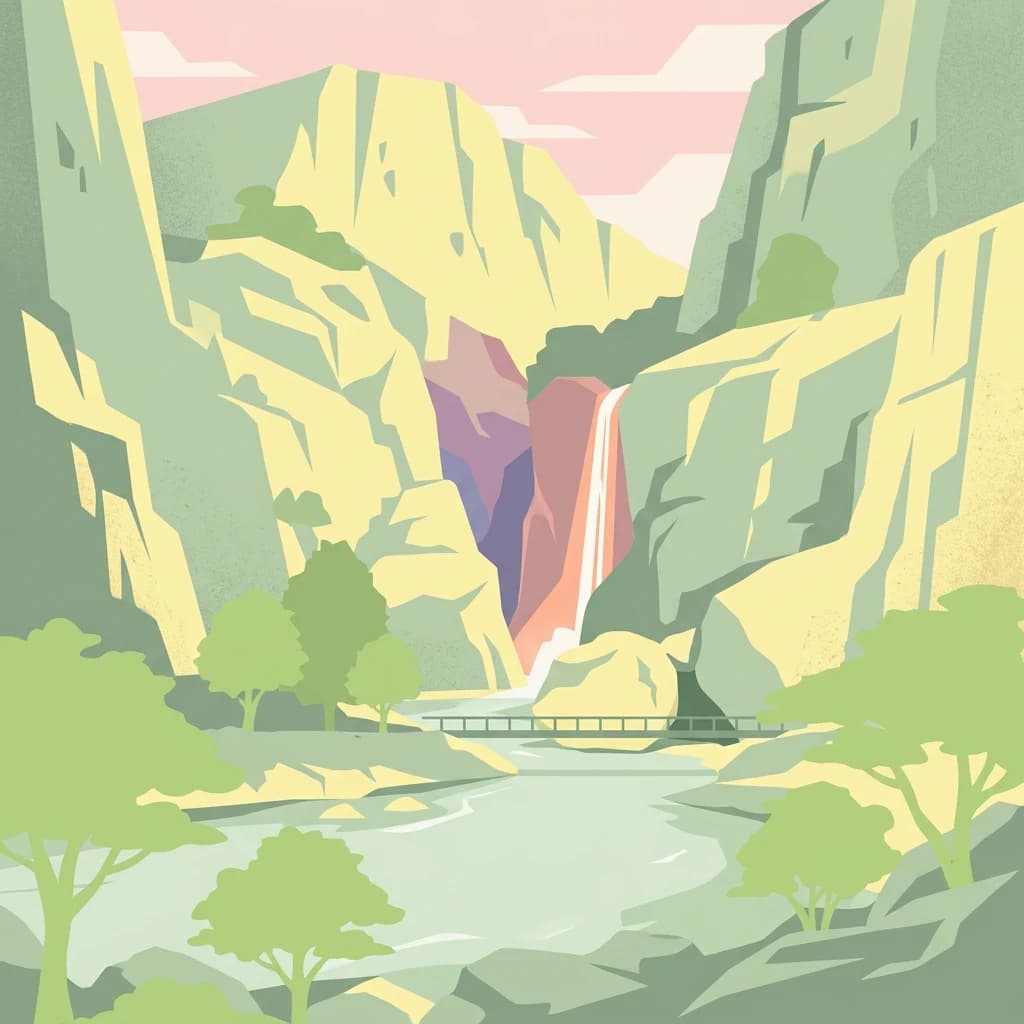
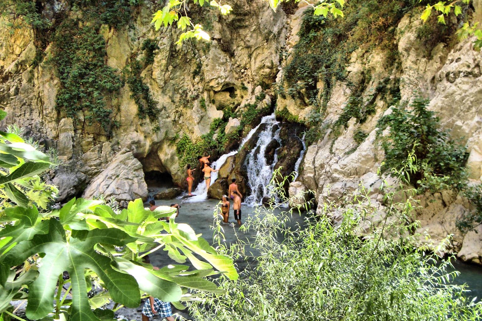
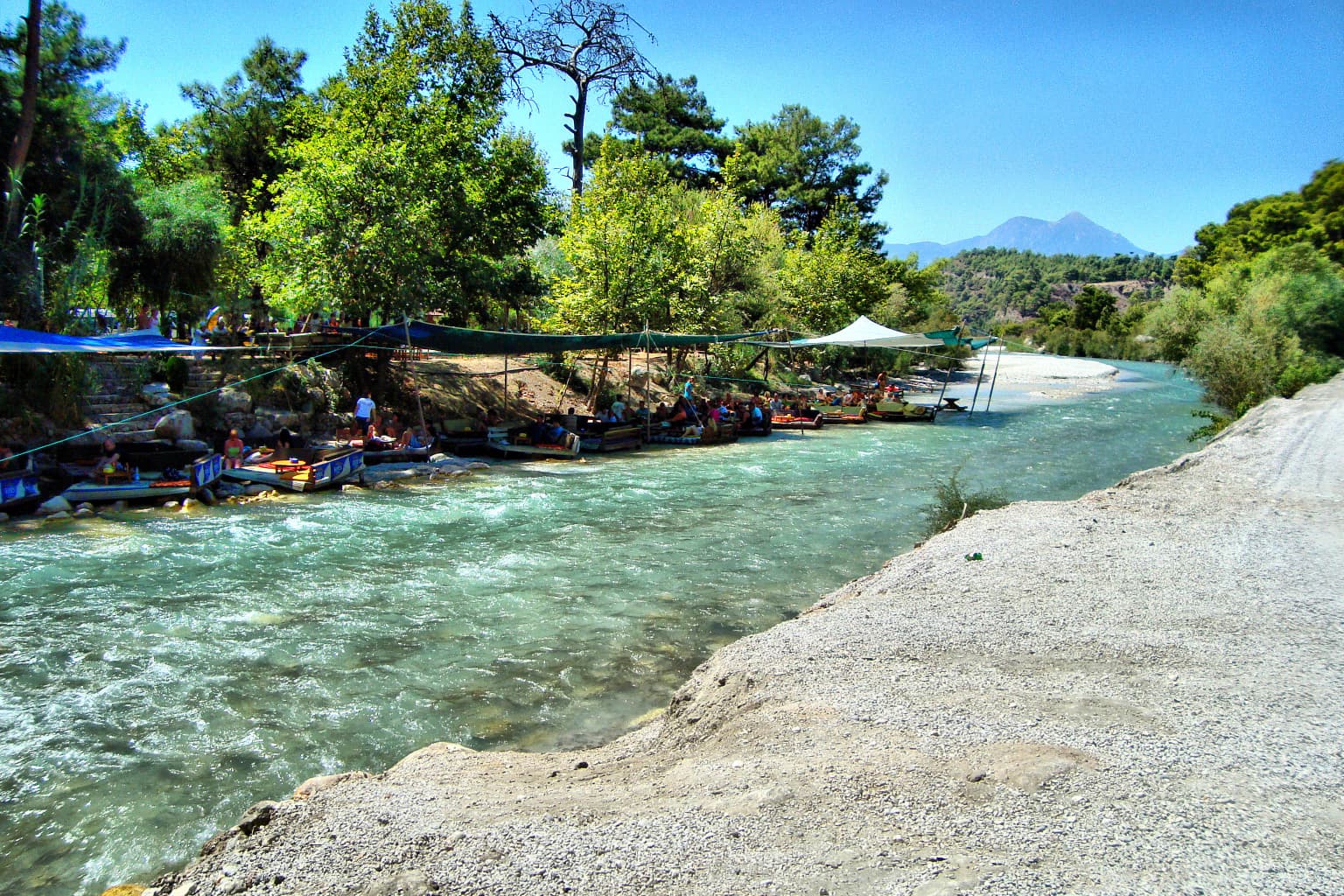
Saklıkent is best known for its spectacular canyon, which ranks among the deepest in the world and offers a unique wilderness experience within Turkey's national park system. The gorge features towering limestone cliffs that create a dramatic narrow passage, with sections so confined that visitors must cross via a 200-meter wooden bridge suspended above the rushing stream below. The canyon is renowned among adventure tourism enthusiasts for its approximately 30 waterfalls and challenging canyoning routes that require professional equipment and expertise to fully explore the full 16-kilometer length. The park also provides access to the Saklıkent ski resort on the nearby Bakırlıdağ peak, offering winter sports opportunities in the Taurus Mountains.

Large light-colored boulder surrounded by rocky canyon walls in a dry riverbed
Large boulder formation within Saklıkent National Park canyon

Saklıkent National Park history and protected-area timeline

Saklıkent National Park was officially established on June 6, 1996, through publication in the Official Gazette of Turkey, designating the canyon and surrounding areas as a protected national park. The discovery of the canyon is relatively recent in historical terms, with local accounts describing how a shepherd chasing an escaped goat first brought attention to this remarkable natural feature. Following reports from local communities, the Ministry of Environment and Forestry recognized the area's significance and designated it for protection. The national park designation followed growing interest in the canyon as a natural attraction and the need to preserve its geological and ecological values amid increasing visitor numbers. Over the subsequent decades, the park has developed visitor infrastructure while maintaining its wilderness character. In 2024, a new wooden bridge was constructed across the waterway to improve access for visitors, reflecting ongoing investment in the park's visitor facilities while preserving the natural setting.

Saklıkent National Park landscape and geographic character

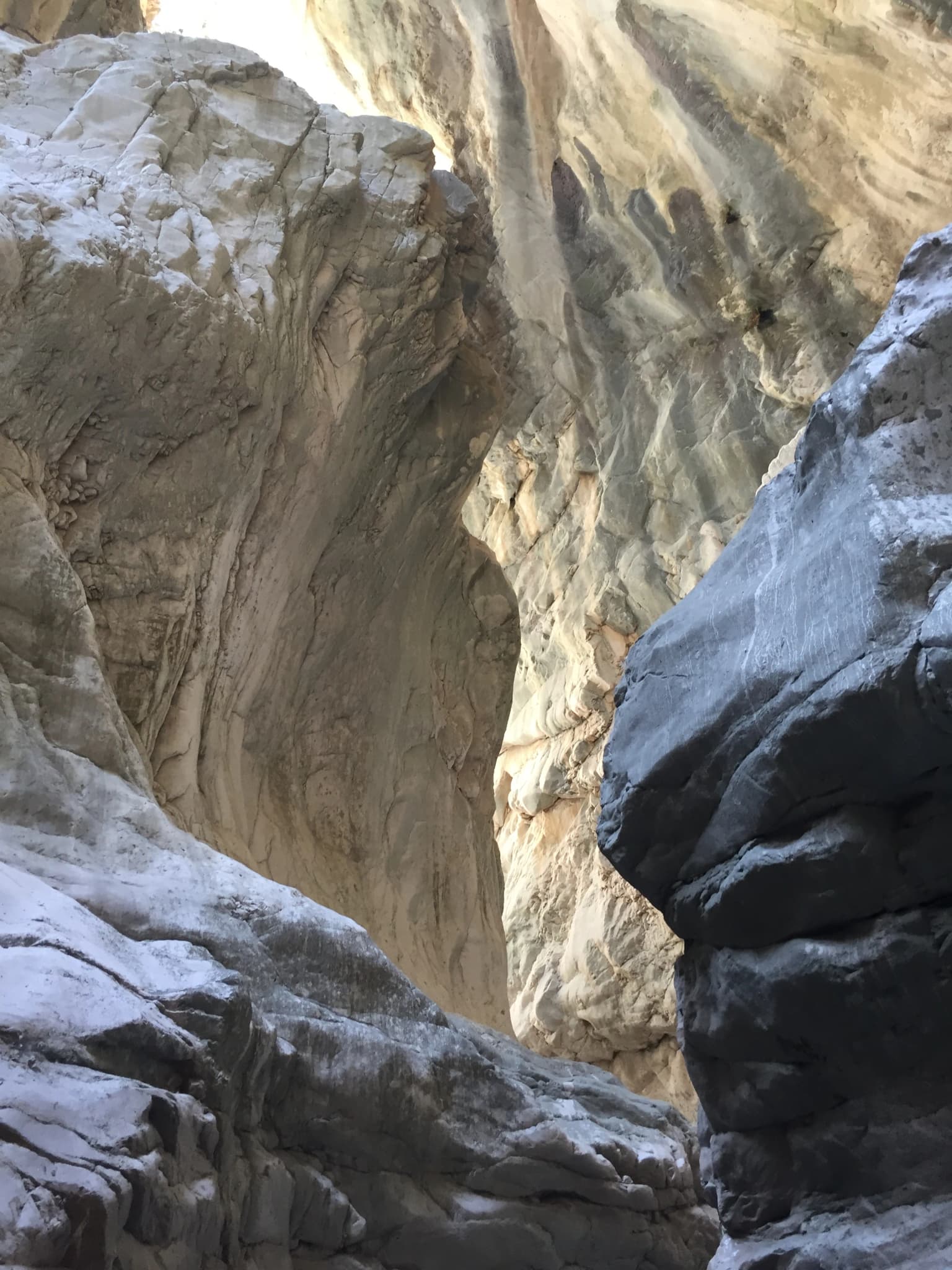
The landscape of Saklıkent National Park is dominated by the dramatic canyon carved by the Karaçay through Cretaceous-era limestone formations. The gorge features vertical walls rising 200 to 300 meters above the canyon floor, with the narrowest passages measuring only 2 meters across, creating a profound sense of enclosure and mystery. The surrounding terrain lies above 1,000 meters in elevation and forms part of the western Taurus Mountains, a major mountain range defining the physical geography of Turkey's Mediterranean coast. The limestone substrate, susceptible to erosion by water, has been sculpted by millennia of fluvial action to produce the spectacular cliffs, overhangs, and hidden chambers visible throughout the canyon. Above the gorge, the landscape transitions to forested slopes and alpine zones, with the peaks of Dumanlıdağ and Bakırlıdağ providing backdrop to the protected area. The continuous flow of cold karstic springs through the canyon maintains a verdant character even in summer, contrasting with the typically arid Mediterranean surroundings.

River flowing through a narrow canyon with steep rocky walls, metal walkway with visitors on the right, and a bridge in the background
River flowing through Saklıkent National Park's steep canyon walls with a metal walkway and bridge in the background

Saklıkent National Park ecosystems, habitats, and plant life

The nature of Saklıkent reflects the Mediterranean to mountain transition zone where the park is situated. At lower elevations approaching the canyon entrance, the vegetation consists of typical maki scrubland with drought-resistant shrubs adapted to the hot, dry Mediterranean climate. As elevation increases within the park, the vegetation transitions through stands of kızılçam (Turkish red pine) to reach karaçam (black pine) forests above approximately 1,000 meters. Particularly notable are the ancient cedar specimens found on the slopes of Dumanlıdağ, some of which qualify as monument trees due to their age and size. The southeastern slopes near Aktar plateau support endemic bulbous plants including cyclamen species that thrive in the higher elevation microclimates. The canyon itself provides habitat for species adapted to the cool, moist conditions of the gorge, with the continuous water flow and shadedcliff faces creating microhabitats distinct from the surrounding landscape.

Waterfall cascading over rocky cliffs with visitors swimming in a pool below, surrounded by green vegetation.
Visitors swimming near a waterfall in Saklıkent National Park.

Saklıkent National Park wildlife and species highlights

While detailed wildlife surveys specific to Saklıkent are limited in the source material, the park's location within the Taurus Mountains places it within an important ecological transition zone between Mediterranean and Anatolian faunal communities. The forested slopes above the canyon provide habitat for typical mountain forest species, while the canyon walls and waters support specialized organisms adapted to the gorge environment. The surrounding protected area encompassing nearly 12,390 hectares includes village lands where traditional agricultural practices support biodiversity. Birdlife in the region includes species characteristic of Mediterranean forest and rocky habitats, though specific species documentation for the park would require additional survey data. The cold, fast-flowing waters of the Karaçay support aquatic ecosystems adapted to the oxygen-rich conditions, though the extreme gorge environment limits opportunities for extensive riparian zones.

Wide river flowing through canyon with rafts, trees, and bridge under clear blue sky
Panoramic view of Saklıkent National Park's river and canyon

Saklıkent National Park conservation status and protection priorities

Saklıkent National Park represents an important conservation designation in Turkey's protected area network, safeguarding a unique geological formation of significant scientific, aesthetic, and ecological value. The national park status provides legal protection for the canyon and its surrounding landscape, limiting potentially damaging development and managing visitor impact on the sensitive gorge environment. The protected area extends beyond the narrow canyon corridor to encompass surrounding forest, alpine zones, and traditional village lands, creating a coherent conservation unit that protects both the geological features and the ecological processes that shape them. The park's designation also serves to preserve the cultural landscape character of this border region between Muğla and Antalya provinces, where highland settlements and traditional land uses have shaped the environment over generations.

Saklıkent National Park cultural meaning and human context

Saklıkent National Park lies in a region of southwestern Turkey with deep connections to Lycian and later Anatolian civilizations, though the canyon itself gained attention only relatively recently in local history. The area falls within the Seydikemer district of Muğla Province and includes villages from both Kaş and Seydikemer administration areas within the broader protected zone. Traditional highland settlements and transhumant practices characterize the surrounding Taurus Mountains, with yayla (summer pasture) settlements providing seasonal occupation. The name Saklıkent, meaning "hidden city" in Turkish, reflects a cultural perception of the canyon as a mysterious, enclosed space. Local communities, particularly from Fethiye and the Mediterranean resort areas, have traditionally visited the canyon for recreation and picnicking, maintaining a connection to this dramatic landscape that predates formal national park designation.

Steep rock formations forming the walls of Saklıkent Canyon National Park
Rock walls of Saklıkent Canyon National Park

Top sights and standout views in Saklıkent National Park

The highlights of Saklıkent National Park center on its extraordinary canyon, one of the deepest and longest in Turkey, offering visitors the chance to experience a dramatic limestone gorge with towering walls, hidden waterfalls, and pristine mountain waters. The accessible lower sections provide an enchanting introduction to the gorge for general visitors, while the full canyon rewards experienced canyoners with technical descents, approximately 30 waterfalls to rappel, and the chance to explore sections accessible only with professional equipment. The park offers a rare combination of natural wonder and adventure opportunity within a protected area framework, with the added dimension of nearby winter sports at the Saklıkent ski resort on Bakırlıdağ. The transition from Mediterranean to mountain ecosystems within the park provides visual and ecological variety, from maki-covered slopes to ancient cedar forests at altitude.

Rocky canyon with a flowing river, wooden boardwalk with green railing on left, and people walking along the path
View of Saklıkent Canyon with a wooden walkway and river

Best time to visit Saklıkent National Park

The best time to visit Saklıkent National Park depends on the type of experience sought. For general sightseeing along the accessible canyon sections, the period from April through October offers the most favorable conditions, with the snowmelt from the Taurus Mountains allowing access to approximately 4 kilometers of walkable canyon after April. Summer months provide the warmest conditions for exploring the gorge, though water levels remain significant year-round due to the karstic springs that feed the stream. The canyon can be entered throughout the year, but the deeper sections become inaccessible during winter months when water levels rise significantly. For those seeking the full canyon experience including technical canyoning, late spring through early autumn provides the optimal window when water levels are lower and weather conditions are most favorable for extended exploration.

Park location guide

Geography guide, regional context, and park location map for Saklıkent National Park

Saklıkent National Park park geography, regions, and map view in Turkey
Understand where Saklıkent National Park sits in Turkey through a broader geographic reading of the surrounding landscape, nearby location context, and its mapped position within the national park landscape.

How Saklıkent National Park fits into Turkey

Turkey, officially the Republic of Türkiye, is a transcontinental country located mainly in Anatolia (West Asia) with a smaller portion in East Thrace (Southeast Europe). It borders the Black Sea to the north, several countries to the east and south, and the Aegean Sea and European countries to the west. The country has a population of over 86 million and operates as a secular, Muslim-majority presidential republic with Ankara as capital and Istanbul as its largest city.

Wider geography shaping Saklıkent National Park in Turkey

Turkey is a transcontinental country with the majority of its territory (about 97%) located in Anatolia (West Asia) and a smaller portion called East Thrace in Southeast Europe. It borders the Black Sea to the north, Georgia, Armenia, Azerbaijan, and Iran to the east, Iraq and Syria to the south, and the Mediterranean Sea to the southwest. To the west, Turkey borders the Aegean Sea, Greece, and Bulgaria. The terrain includes mountains, plateaus, and coastal plains, with the Taurus Mountains running along the southern coast.

Map view of Saklıkent National Park

Use this park location map to pinpoint Saklıkent National Park in Turkey, understand its exact geographic position, and read its mapped placement within the surrounding landscape more clearly.

Pigeon | © OpenStreetMap contributors

Location context for Saklıkent National Park

Muğla Province

A visual atlas of Saklıkent's deep gorges, towering limestone formations, and the protected-area environment within Turkey's Taurus Mountains

Saklıkent National Park Photos: Explore Dramatic Canyon Landscapes and Unique Geological Scenery
Browse imagery of Saklıkent National Park to visually explore its dramatic limestone canyon, deep river gorges, and striking geological formations. These photographs offer a detailed perspective on the park's unique protected landscapes and the rugged terrain of the Taurus Mountains.

Large light-colored boulder surrounded by rocky canyon walls in a dry riverbed

Pedestrian bridge crossing turquoise river in deep canyon with rocky cliffs and vegetation

River flowing through a narrow canyon with steep rocky walls, metal walkway with visitors on the right, and a bridge in the background

Waterfall cascading over rocky cliffs with visitors swimming in a pool below, surrounded by green vegetation.

Wide river flowing through canyon with rafts, trees, and bridge under clear blue sky

Person standing on a rock ledge beside a turquoise river in a canyon with steep rocky walls

Steep rock formations forming the walls of Saklıkent Canyon National Park

Rocky canyon with a flowing river, wooden boardwalk with green railing on left, and people walking along the path

A wide view of Saklıkent Canyon with steep rocky cliffs and a river flowing through the canyon

Two people walking on a dry riverbed in a deep canyon with rocky cliffs on both sides

Steep rocky canyon walls with a narrow stream at the bottom and small group of people walking in the distance

Park atlas

Compare the Protected Landscapes and Canyon Formations of Southwestern Turkey

Explore Other National Parks and Protected Areas Near Saklıkent National Park
Browse an extensive atlas of national parks and protected areas surrounding Saklıkent National Park, mapping diverse landscapes across the Taurus Mountains and southwestern Turkey. Continue your geographic exploration by comparing other canyon systems, Mediterranean forests, and karstic terrain, gaining broader context for conservation efforts in the region.
National parkMuğla Province

Marmaris National Park: Mediterranean Forest Protected Landscape and Ancient Heritage

Discover its geography, mapped boundaries, and unique flora.

Marmaris National Park in Muğla Province offers a deep dive into a protected Mediterranean forest ecosystem and Carian history. Explore its rugged terrain, dramatic coastlines where pine forests meet the sea, and discover ancient sites like the Amos amphitheatre. This park is a key area for understanding regional geography, mapped natural landscapes, and the unique botanical diversity of Turkey's southwestern coast, supporting detailed atlas exploration.

Area
333.5 km²
Established
1996
Visitors
8.5M annual
Relief
Mixed relief
Watercolor painting showing a lake, mountains, trees, and grassy shoreline
National parkIsparta Province

Lake Kovada National Park: Mapped Protected Landscape in Isparta Province

Discover the geography and lake ecosystem of this Turkish national park.

Lake Kovada National Park offers a detailed look at a protected natural area within Turkey's Isparta Province. This page provides insights into the park's protected landscape, focusing on the central freshwater lake and its surrounding montane terrain. Explore its geographic context, mapped boundaries, and status as a significant protected area within the Taurus Mountain region, ideal for atlas-based discovery of Anatolian natural environments.

Area
65.51 km²
Established
1970
Scope
Terrestrial
Water
Major water bodies
Watercolor illustration showing a mountainous landscape with a lake and greenery
National parkAntalya Province

Altınbeşik Cave National Park: A Karst Landscape with Turkey's Largest Subterranean Lake

Protected lands and mapped geological formations in Antalya Province.

Altınbeşik Cave National Park represents a significant protected karst landscape within Antalya Province, Turkey. The park's primary feature is the renowned Altınbeşik Cave, home to Turkey's largest subterranean lake and exceptional travertine formations. Explore the mapped geography of this unique national park, understanding its role as a critical discharge point for one of the world's longest karst aquifer systems.

Area
11.47 km²
Established
1994
Relief
Mixed relief
Climate
Mediterranean
National parkTurkey

Derebucak Çamlık Caves National Park: Turkey's Protected Karst Caves and Landscape

Explore Konya Province's longest cave system and its unique geological context.

Derebucak Çamlık Caves National Park is a vital protected landscape in central Turkey, celebrated for its extensive karst topography and significant cave formations. This national park encompasses thirteen unique caves and sinkholes, with Balatini Cave holding the distinction of being Konya Province's longest. The park's rugged terrain, characterized by pine forests and the Balat Stream feeding its underground systems, offers a profound look into Turkey's geological heritage and the conservation of its unique subterranean environments. MoriAtlas helps you navigate this mapped protected area.

Area
11.47 km²
Established
2022
National parkAydın Province

Dilek Peninsula-Büyük Menderes Delta National Park: Protected Landscape and Geographic Context

Aydın Province's unique national park with diverse ecosystems.

Investigate Dilek Peninsula-Büyük Menderes Delta National Park, a key protected area in Turkey's Aydın Province. This page provides detailed geographic context, highlighting the park's remarkable coexistence of mountainous terrain and essential wetland habitats. Understand the mapped boundaries and landscape characteristics that define this significant national park.

Area
275.98 km²
Established
1966
IUCN
II
Watercolor painting of colorful rowboats on a lake with distant mountains
National parkKonya Province

Lake Beyşehir National Park: Protected Landscape Geography and Mapped Boundaries

Discover the geography and mapped context of this national park in Konya.

Lake Beyşehir National Park is a major protected area in Turkey's Central Anatolia region, celebrated for its immense freshwater lake and diverse wetland habitats. The park's identity is strongly tied to its mapped boundaries that protect critical ecosystems, islands, and surrounding forested terrain. This page provides a detailed look at the park's geographic setting within Konya Province, serving as a valuable resource for atlas-based discovery of its unique natural and cultural landscape.

Area
868.55 km²
Established
1993
Relief
Lowland
Climate
Temperate
Watercolor illustration of green hills, pine trees, and distant mountains under a light sky
National parkIsparta Province

Kızıldağ National Park: Protected Taurus Mountain Landscape and Atlas Context

Mapped boundaries, alpine terrain, and unique cedar forests.

Kızıldağ National Park offers a detailed look into Turkey's protected natural heritage, specifically highlighting the dramatic mountainous terrain of the Taurus Ranges. This page provides atlas-level geographic information about its mapped boundaries, the significant Dedegöl Mountain, and the rare blue-leaf cedar forests unique to this region. Understand its role as a vital conservation area within Isparta Province and the broader Mediterranean mountain ecosystem.

Area
551.06 km²
Established
1969
Relief
Mountain
Scope
Terrestrial
Protected areaTurkey

Commander-in-Chief National Historic Park: Historic Battlefield Landscape in Turkey

Protected Area preserving pivotal geography and military history.

Commander-in-Chief National Historic Park is a designated protected area in Turkey, preserving the historic terrain of the decisive Battle of Dumlupınar. This site offers a unique glimpse into the geography and landscape that were instrumental in a key moment of the Turkish War of Independence. Explore the mapped context of this significant battlefield, understanding its role within the broader Anatolian geography and its importance as a preserved historic site.

Area
409.48 km²
Established
1981
Relief
Mixed relief
Climate
Temperate

Common questions about visiting, size, designation, and location context for Saklıkent National Park

Saklıkent National Park FAQs for park facts, access, geography, and protected area context
Find quick answers about Saklıkent National Park, including protected-area facts, park geography, trail and visitor context, and how the park fits into its surrounding country and regional landscape.
MoriAtlas Explorer

Continue Your Protected Areas Search Across the Global Atlas

Deepen your exploration by continuing the structured search for national parks and protected areas worldwide. Utilize the comprehensive filtering capabilities to compare different conservation landscapes and refine your understanding of global park geography. Discover more about the distribution and characteristics of protected natural areas.

Global natural geography