Mori Atlas logo
National parkSalair National Park

Discover the unique dark taiga terrain and relict flora of this Siberian national park.

Salair National Park: Protected Landscape and Geographic Context in Altai Krai, Russia

(National Park Salair)

Salair National Park, a protected area established in 2020 within Altai Krai, Russia, showcases the distinctive dark taiga forests and unique relict plant species of southern Siberia. Occupying approximately 161,000 hectares on the western slopes of the Salair Ridge, this national park offers a critical insight into Russia's protected landscapes. Its terrain features gentle mountainous slopes and a networked system of ravines, with Mount Kivda as its highest peak, contributing to a rich mosaic of microhabitats. The park's existence preserves a crucial ecological archive distinct from the surrounding agricultural regions.

Dark TaigaSiberian ForestRelict PlantsMontane EcosystemsConiferous ForestBiodiversity Hotspot
Digital illustration of a waterfall in a coniferous forest with mountains and a lake.

Salair National Park

National park

Park overview

Structured park overview, official facts, and landscape profile for Salair National Park

Salair National Park park facts, protected area profile, and essential visitor context
Review the core facts for Salair National Park, including designation, size, terrain, visitor scale, habitats, and operating context in one park-focused overview.

About Salair National Park

Salair National Park protects a critical expanse of montane forest ecosystem in southern Siberia, where the low Salair Ridge forms a transition zone between the great Altai Mountains to the east and the vast Western Siberian plain to the west. The park's establishment in 2020 reflected growing recognition that this relatively modest mountain ridge harbors ecological values out of proportion to its modest elevation. The dark taiga forest blanket covering the ridges contains Siberian pine, Siberian spruce, and Siberian fir in mature stands, with an understory of Siberian linden and vertically developed shrub and grass layers. These forests support species typically found much further south, preserved here because the Salair Ridge captures moisture from westerly airflow, creating the humid conditions that scientists have compared to rainforest environments. The surrounding landscapes outside the park have been extensively transformed by agriculture, leaving the protected forest as a significant island of intact ecosystem in a largely cleared landscape.

Quick facts and research context for Salair National Park

Salair National Park covers 161,221 hectares (622 square miles) of mountainous terrain in the Altai Republic, Russia. The park was officially established on September 11, 2020, making it one of Russia's newer protected areas. The Salair Ridge functions as a biogeographic boundary between the Altai Mountains and the Western Siberian plain. The park features humid continental climate with warm summers (Köppen Dfb classification), supporting the unusual presence of diverse forest ecosystems at this northern latitude. The surrounding lowlands outside the park have been largely converted to agricultural steppe and forest-steppe.

Park context

Deeper park guide and search-rich context for Salair National Park

Salair National Park history, landscape, wildlife, and travel context
Explore Salair National Park through its history, landscape character, ecosystems, wildlife, conservation priorities, cultural context, and seasonal travel timing in a structured park guide built for atlas discovery and search intent.

Why Salair National Park stands out

Salair National Park is best known for its remarkable "dark taiga" coniferous forests that resemble a Siberian rainforest in biodiversity and structure. The park preserves the only stand of indigenous Populus tremula (quaking aspen) in all of Siberia, along with ancient Siberian pines reaching up to 800 years old. Its warm, humid summers have created conditions for the survival of pre-glacial relict plant species, making it a living archive of Eurasian forest history. The combination ofmontane conifer forest with well-developed understory and rare plant communities distinguishes Salair from surrounding agricultural landscapes.

A serene lake reflecting green trees and hills in a forested landscape with a clear blue sky
Scenic landscape of Salair National Park featuring a calm lake surrounded by coniferous forest and rolling hills under clear blue sky

Salair National Park history and protected-area timeline

Salair National Park was officially established on September 11, 2020, representing one of the more recent additions to Russia's national park system. The creation of the park fulfilled years of scientific advocacy highlighting the ecological significance of the Salair Ridge's forest ecosystems. Prior to formal protection, the area faced ongoing pressure from logging and agricultural expansion into the forest-steppe zone. The park is administered by FGBU "Salair" and encompasses territory in the Zarinsk, Togulsky, Yeltsovsky, and Soltonsky districts of Altai Krai. The establishment of protected status acknowledged the scientific designation of Salair as a "rainforest of Siberia" based on its warm, humid summer climate and the resulting biodiversity preserved within its forests.

Salair National Park landscape and geographic character

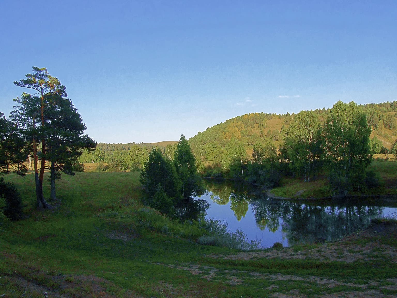
The Salair Ridge presents a landscape of gentle, rounded mountains extending as a northern extension of the Altai Mountains system. The terrain within the park features a highly networked system of ravines and valleys that break the otherwise rolling ridgeline. The highest point within the park boundaries is Mount Kivda at 621 meters (2,037 feet), though the surrounding terrain outside the protected area remains similarly modest in elevation. The western slopes descend toward the Ob River basin and the agricultural lowlands of Altai Krai, while the eastern side transitions into the more forested landscapes of Kemerovo Oblast. The combination of rounded hilltops, forested slopes, and the intricate valley network creates a mosaic of microhabitats that contributes to the park's ecological diversity.

Salair National Park ecosystems, habitats, and plant life

The forest ecosystems of Salair National Park represent a distinctive form of dark taiga that differs from typical Siberian boreal forest in its species composition and structural complexity. The dominant tree species include Pinus sibirica (Siberian pine), Picea obovata (Siberian spruce), and Abies sibirica (Siberian fir), forming dense canopy stands. Unusually, the forest also contains Tilia sibirica (Siberian linden), a broadleaf species more typical of temperate forests far to the south. The forest floor supports a rich herb layer including Asperula odorata, Asarum europaeum, Sanicula europaea, and Brachypodium sylvaticum. At lower altitudes and in forest clearings, tall grasses and meadow steppe vegetation appear. The park contains the only indigenous stand of Populus tremula (quaking aspen) in all of Siberia, a botanical anomaly that underscores the relict character of these forests.

Salair National Park wildlife and species highlights

The mammal community of Salair National Park includes several species typical of Siberian forest ecosystems. Elk and red deer inhabit the forest and forest edges, while roe deer occupy more open areas and forest margins. Smaller mammals include marmots in rocky areas and meadow zones, American mink along watercourses, and beaver in riparian habitats. The diverse forest structure, combining coniferous canopy with deciduous understory and rich ground vegetation, provides habitat for species requiring varied foraging resources. The presence of old-growth forest elements, including ancient pines reaching 800 years of age, supports species associated with decaying wood and veteran tree microhabitats.

Salair National Park conservation status and protection priorities

Salair National Park represents a critical conservation stronghold in a region where surrounding lowlands have been largely converted to agriculture. The park preserves the last significant tract of montane dark taiga forest in the Salair Ridge system, protecting relict species communities that survived from pre-glacial periods and cannot persist in transformed agricultural landscapes. The designation as IUCN Category II reflects international recognition of the park's significance for biodiversity preservation. The "rainforest of Siberia" characterization highlights how this modest mountain ridge supports biological diversity typically associated with much more southerly latitudes, making it a unique conservation priority within the Western Siberian ecoregion.

Top sights and standout views in Salair National Park

The ancient Siberian pines of Salair, some reaching 800 years of age, represent living monuments of forest history spanning centuries of ecological continuity. The park contains the sole remaining stand of indigenous quaking aspen in all of Siberia, a botanical phenomenon of significant scientific interest. Its designation as a "rainforest of Siberia" reflects the unusual combination of humid summer conditions and diverse forest structure found nowhere else in this latitude across Eurasia. The contrast between the intact forest of the protected slopes and the agricultural steppe of the surrounding lowlands illustrates the ecological value of protected areas in heavily modified landscapes.

Best time to visit Salair National Park

The warm summer months from June through August offer the most favorable conditions for visiting Salair National Park, when the humid continental climate produces the mild temperatures and accessible conditions that give the region its "rainforest" character. Summer visits allow observation of the forest in full growth, with the rich understory vegetation and diverse plant communities at their most visible. The shoulder seasons of spring and autumn provide different forest character, with spring bringing new growth and autumn displaying the color changes typical of mixed forest. Winter visits would encounter the harsh continental conditions typical of Siberian interior regions, with heavy snow and frozen conditions limiting accessibility.

Park location guide

Geography guide, regional context, and park location map for Salair National Park

Salair National Park park geography, regions, and map view in Russia
Understand where Salair National Park sits in Russia through a broader geographic reading of the surrounding landscape, nearby location context, and its mapped position within the national park landscape.

How Salair National Park fits into Russia

Russia is a transcontinental nation spanning eleven time zones, bordered by fourteen countries. It is the world's largest country by area, covering 17,098,246 km². Moscow is the capital and largest city, while Saint Petersburg is the second-largest and a major cultural centre.

Wider geography shaping Salair National Park in Russia

Russia spans Eastern Europe and North Asia, covering 17,098,246 km². It shares land borders with fourteen countries, more than any other nation, and spans eleven time zones. The landscape includes vast plains, mountain ranges such as the Urals and Caucasus, and extensive coastlines along the Arctic Ocean, Pacific Ocean, Baltic Sea, Black Sea, and Caspian Sea.

Map view of Salair National Park

Use this park location map to pinpoint Salair National Park in Russia, understand its exact geographic position, and read its mapped placement within the surrounding landscape more clearly.

Pigeon | © OpenStreetMap contributors

Location context for Salair National Park

Altai Krai

Visualizing the Dark Taiga, Ancient Forests, and Mountain Scenery of Salair's Protected Area

Explore Salair National Park Through Images: Discover Its Unique Siberian Landscapes
Visually explore Salair National Park's compelling landscapes, from its famed dark taiga forests to its rolling low mountain terrain. These protected area images reveal the park's unique relict plant habitats and ancient Siberian pine stands, offering key insights into its ecological significance and distinctive Siberian character.

A serene lake reflecting green trees and hills in a forested landscape with a clear blue sky

Park atlas

Trace the regional context of protected areas, comparing landscapes surrounding Salair National Park.

Discover Nearby National Parks and Protected Areas Around Salair National Park
After exploring Salair National Park's unique dark taiga forests, browse other national parks and protected areas across the Altai-Sayan mountain system and surrounding southern Siberia. Compare montane ecosystems and forest reserves, tracing the regional spread of conservation efforts and understanding varied protected landscapes within this extensive Eurasian geography.
National parkTashtagolsky District

Shorsky National Park: Protected Landscape and National Park Geography

Discover the mapped terrain and regional context of Shorsky National Park.

Shorsky National Park is a key protected area within the Tashtagolsky District, nestled in the mountainous terrain of Southern Siberia. This page serves as an entry point for understanding its role as a national park, focusing on its geographic boundaries and landscape context. MoriAtlas allows for detailed map-based exploration of Shorsky National Park, highlighting its significance within the regional geography and the broader atlas of protected lands in Russia.

Area
4,180 km²
Established
1989
IUCN
II
Watercolor painting of green trees, rolling hills, a pink and yellow sunset sky, and a single tree on the right
National parkKrasnoyarsk Krai

Shushensky Bor National Park: Mapped Geography of a Siberian Protected Forest

Explore the protected landscape and regional context of Krasnoyarsk Krai.

Shushensky Bor National Park serves as a critical protected area within the vast geography of Krasnoyarsk Krai, Russia, offering detailed insights into Siberia's ecological transition zones. This national park meticulously maps the shift from the Minusinsk basin forest-steppe to the dramatic mountain taiga of the Western Sayan range. Users can explore its varied terrain, from gentler northern steppe-influenced lands to the rugged slopes of the Borus Massive, all within a defined protected landscape. The proximity to the Sayano-Shushenskoye Reservoir further defines its unique geographic setting, providing context for its conservation importance and natural beauty.

Area
392 km²
Established
1995
IUCN
II
Relief
Mountain
National parkKrasnoyarsk Krai

Krasnoyarsk Pillars National Park: Geographic Atlas and Protected Landscape Exploration

Discover mapped terrain and regional park context in Siberia.

This detailed entry for Krasnoyarsk Pillars National Park offers an in-depth look at its identity as a protected landscape within Krasnoyarsk Krai. It provides structured geographic information, focusing on mapped boundaries and the park's position within the vast Siberian terrain. Users can leverage this data for atlas exploration, gaining a clear understanding of the park's physical dimensions and its role in the regional geography of Russia. Explore the unique landscape character and mapped context of this significant national park.

Area
471.54 km²
Established
2019
IUCN
II
Visitors
200K annual
National parkAltai Republic

Saylyugemsky National Park: Discover its Protected Landscape and Geographic Significance in Altai Republic

Mapped boundaries and regional landscape context within the Altai Republic.

Delve into Saylyugemsky National Park, a designated national park situated within the vast geographic expanse of Russia's Altai Republic. This canonical page provides detailed insights into its protected landscape, meticulously mapped boundaries, and its contribution to the regional geography. MoriAtlas focuses on structured geographic discovery, enabling a deeper understanding of Saylyugemsky National Park's place within the atlas of protected areas and natural landscapes.

Area
1,183.8 km²
Established
2012
IUCN
II
Relief
Mountain
National parkEast Kazakhstan Region

Katon-Karagay National Park: Discover Kazakhstan's Largest Protected Mountain Landscape

Explore the geography and park boundaries of East Kazakhstan's premier national park.

Katon-Karagay National Park, the largest national park in Kazakhstan, offers a deep dive into the protected landscapes of the Southern Altai Mountains. This page provides essential geographic context, detailing the park's terrain, its significance as a protected area within East Kazakhstan Region, and its role in mapping the natural contours of this ecologically diverse mountain system. Understand the park's boundaries and its contribution to regional conservation.

Area
6,435 km²
Established
2001
IUCN
II
Relief
Mountain
National parkEast Kazakhstan Region

Tarbagatai National Park: Protected Landscape and Wild Fruit Tree Forests in East Kazakhstan Region

Explore the mapped boundaries and ecosystem of this national park.

Tarbagatai National Park is a protected area in East Kazakhstan recognized for its unique role in conserving wild fruit tree forests that have maintained genetic isolation. This national park provides a detailed view of a mountain-steppe ecosystem across the Tarbagatai mountain range, Karabas Mountains, and Arkaly Mountains, along with the Urzhar and Emel river valleys. Its establishment in 2018 highlights its importance for biodiversity and the study of natural forest genetics, offering significant geographic context for regional protected land exploration.

Area
1,364 km²
Established
2018
IUCN
II
Relief
Mountain
National parkKazakhstan

Bayanaul National Park: Kazakhstan's First National Park Mapped Landscape

Explore granite mountains, unique lakes, and striking rock formations.

Bayanaul National Park, situated in Kazakhstan's Pavlodar Province, represents a significant protected area renowned for its extraordinary granite mountain landscape. Established as the country's first national park, it showcases unique erosion-shaped rock formations, diverse vegetation including rare pines, and four significant freshwater lakes. This park offers a distinct visual tapestry of mountainous terrain and geological wonders within the broader Central Asian geography, making it a key destination for atlas-based discovery.

Area
684.53 km²
Established
1985
IUCN
II
Watercolor illustration of a mountainous landscape with green hills, trees, and a river in the foreground
National parkKazakhstan

Karkaraly State National Nature Park: Kazakhstan's Mountain-Forest Protected Area

Discover unique geology, archaeology, and regional landscape context.

Delve into the distinctive protected landscape of Karkaraly State National Nature Park, situated in Kazakhstan's Karaganda Region. This park preserves a rare mountain-forest ecosystem with dramatic granite formations, ancient archaeological sites, and lakes, presenting a rich geographic contrast to the surrounding Kazakh Steppe. MoriAtlas provides structured insights into Karkaraly State National Nature Park's unique terrain, its conservation value, and its position within the broader regional geography of Central Asia.

Area
1,121.2 km²
Established
1998
IUCN
II
Relief
Mountain

Common questions about visiting, size, designation, and location context for Salair National Park

Salair National Park FAQs for park facts, access, geography, and protected area context
Find quick answers about Salair National Park, including protected-area facts, park geography, trail and visitor context, and how the park fits into its surrounding country and regional landscape.
MoriAtlas Explorer

Continue Your Protected Areas Search Across the Global Atlas

Deepen your exploration by continuing the structured search for national parks and protected areas worldwide. Utilize the comprehensive filtering capabilities to compare different conservation landscapes and refine your understanding of global park geography. Discover more about the distribution and characteristics of protected natural areas.

Global natural geography