Mori Atlas logo
National parkShushensky Bor National Park

Explore the mapped transition zone from forest-steppe to mountain taiga in Krasnoyarsk Krai.

Shushensky Bor National Park: A Protected Landscape at the Crossroads of Siberian Geography

Shushensky Bor National Park represents a vital protected area in the southwestern Siberian geography of Krasnoyarsk Krai, meticulously preserving the ecological boundary between the Minusinsk basin forest-steppe and the imposing mountain taiga of the Western Sayan Mountains. This national park offers a unique atlas perspective, detailing approximately 39,180 hectares of diverse terrain where rolling steppe landscapes gradually ascend into rugged, conifer-clad slopes. The park’s strategic position showcases a significant regional ecological gradation, making its mapped boundaries essential for understanding Siberian natural landscapes.

Siberian taigamountain forestsWestern Sayan Mountainsprotected forestalpine meadowsbirdwatching
Illustration of a mountainous landscape featuring a waterfall, forested slopes, a river, and a prominent tree in the foreground

Shushensky Bor National Park

National park

Park overview

Structured park overview, official facts, and landscape profile for Shushensky Bor National Park

Shushensky Bor National Park park facts, protected area profile, and essential visitor context
Review the core facts for Shushensky Bor National Park, including designation, size, terrain, visitor scale, habitats, and operating context in one park-focused overview.

About Shushensky Bor National Park

Shushensky Bor National Park occupies a remarkable position at the geographic and ecological crossroads of southern Siberia. The protected area was established in 1995 to preserve the distinctive forests that blanket the northern foothills of the Western Sayan Mountains, as well as the forest-steppe transitional zones extending into the Minusinsk basin. This combination of ecological zones within a single protected area makes Shushensky Bor particularly valuable for conservation and scientific study.

The park's two distinct sections reflect the topographic and climatic gradient from north to south. The smaller Perovsky section in the north covers approximately 4,410 hectares of relatively flat forest-steppe terrain, representing the southern fringe of the Minusinsk basin. This area supports the lighter, more open woodlands typical of the transition between true steppe and dense taiga forest. The larger mountain section encompasses approximately 34,760 hectares on the north-facing slopes of the Western Sayan range, where the terrain rises dramatically and the vegetation shifts to dense conifer forest characteristic of Siberian taiga.

The western and southern boundaries of the mountain section are defined by the Sayano-Shushenskoye Reservoir, a massive artificial lake created by the Sayano-Shushenskaya Dam—the largest hydroelectric facility in Russia. The reservoir's presence transforms the landscape, with the park's forested slopes descending directly to the water's edge in places. This proximity to such a significant body of water also influences local climate and supports additional habitat diversity within the park.

Quick facts and research context for Shushensky Bor National Park

Shushensky Bor National Park covers 39,180 hectares in southwestern Siberia, established in 1995 and managed by FGBU Shushensky Bor. The park is located in Krasnoyarsk Krai near the village of Shushenskoye, approximately 60 kilometers north of the main ridge of the Western Sayan Mountains. It is divided into two main sections: a smaller forest-steppe area called Perovsky in the north, and a larger mountain section encompassing the Borus Massive, a ridge of five peaks reaching 2,309 meters at Mount Poilovo. The park lies within the Sayan montane conifer forests ecoregion and experiences a humid continental climate with warm summers and cold, snowy winters.

Park context

Deeper park guide and search-rich context for Shushensky Bor National Park

Shushensky Bor National Park history, landscape, wildlife, and travel context
Explore Shushensky Bor National Park through its history, landscape character, ecosystems, wildlife, conservation priorities, cultural context, and seasonal travel timing in a structured park guide built for atlas discovery and search intent.

Why Shushensky Bor National Park stands out

Shushensky Bor is best known for its dramatic ecological transition zone, where Siberian forest-steppe gives way to mountain taiga within a single protected area. The park protects representative examples of both the Minusinsk basin forest-steppe and the Western Sayan mountain conifer forests, making it an important living laboratory for understanding Siberian ecology. The Borus Massive, with its five towering peaks, provides the park's most distinctive topographic feature, while the southern boundary along the vast Sayano-Shushenskoye Reservoir creates a unique landscape of forested slopes descending to the reservoir's shoreline. The park also supports significant biodiversity including rare species such as the sable, black stork, and golden eagle.

Snow-covered ground with a single coniferous tree in the foreground, rocky terrain, and a mountain slope covered in trees and snow under a clear blue sky
Snow-covered mountain landscape with coniferous trees and a lone tree in Shushensky Bor National Park

Shushensky Bor National Park history and protected-area timeline

Shushensky Bor National Park was established in 1995 as a protected area designed to preserve the representative forests of the southern Siberian foothills. The creation of the park reflected growing recognition of the ecological significance of the Western Sayan mountain forests and the transitional forest-steppe zones of the Minusinsk basin. The park was placed under the management of FGBU Shushensky Bor, the federal budget institution responsible for its ongoing administration and conservation.

The establishment of the park coincided with broader developments in Russian protected area policy during the 1990s, a period that saw the creation of numerous new national parks and reserves across the country. The selection of this particular area for protection was influenced by its combination of ecological diversity, scenic quality, and the presence of relatively intact forest ecosystems. The park's location near the developing Sayano-Shushenskaya hydroelectric project also brought attention to the need for environmental protection in the region.

Shushensky Bor National Park landscape and geographic character

The landscape of Shushensky Bor National Park is defined by the interplay between mountainous terrain and the ecological transition between forest-steppe and taiga. The park's northern portion consists of gently rolling terrain on the forest-steppe of the Minusinsk basin, where the land is relatively flat and the vegetation reflects the transitional nature of this zone between open grassland and dense forest. This area presents a more open landscape compared to the mountain section, with lighter tree cover and greater visibility across the terrain.

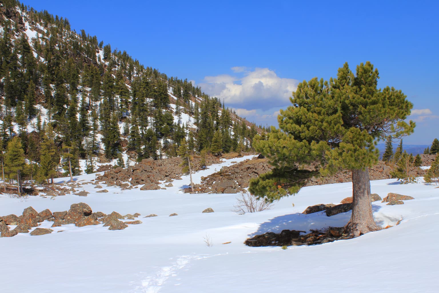
The southern mountain section presents a dramatically different character, characterized by the rugged ridge of the Borus Massive—a north-south oriented mountain spine featuring five distinct peaks, with Mount Poilovo rising to 2,309 meters as the highest point. The slopes of this ridge are clothed in dense conifer forest that ascends from the lower elevations to the subalpine zone. Above approximately 1,400 meters, the forest gives way to light needle-leaf sparse taiga, and the highest elevations support alpine tundra and meadows. The western and southern edges of this section drop sharply to the shoreline of the Sayano-Shushenskoye Reservoir, creating a striking contrast between the dark conifer-covered slopes and the open water.

Shushensky Bor National Park ecosystems, habitats, and plant life

The ecological character of Shushensky Bor is defined by its position within the Sayan montane conifer forests ecoregion, a WWF-designated region that describes the mid-elevation zones of the high Siberian mountains. This ecoregion represents the transition between the vast Siberian taiga to the north and the Mongolian steppe to the south, creating a gradient of vegetation types that is reflected within the park's boundaries. The park's altitudinal zoning creates three distinct forest subzones: below 900 meters, black taiga pine forest dominates on the rich alluvial soils of the valley bottoms; between 900 and 1,400 meters, dark needle-leaf taiga covers the slopes; and above 1,400 meters, light needle-leaf sparse taiga gives way to subalpine conditions.

The diversity of habitats within the park supports a wide range of plant communities. The alpine meadows that appear above the treeline in summer are particularly notable, bursting into color with diverse wildflowers against the backdrop of rocky peaks and sparse vegetation. The forest-steppe zone in the northern portion of the park supports a different suite of species adapted to the more open conditions and greater temperature extremes of this transitional environment. The presence of the Sayano-Shushenskoye Reservoir along the southern boundary adds aquatic and riparian habitats to the park's ecological repertoire.

Shushensky Bor National Park wildlife and species highlights

Shushensky Bor National Park supports a diverse mammalian fauna typical of the Siberian forest and forest-steppe zones. The mammalian community includes species such as brown bear, red deer, roe deer, elk, and wild boar, which represent the larger herbivores present in the area. Smaller mammals are also well-represented, with species including hare, red squirrel, and the commercially valuable sable—a member of the weasel family highly prized for its fur. Predatory mammals include the common fox, while musk deer represents a distinctive species of the forested slopes.

Bird diversity is particularly notable, with records indicating the presence of 272 bird species within the park. The avifauna includes several species of significant conservation interest, among them the golden eagle, a striking raptor of the mountainous terrain, the osprey, which hunts along the reservoir and waterways, and the black stork, an elegant species associated with forested wetlands and water bodies. This rich bird community reflects the diversity of habitats within the park, from alpine meadows to forest slopes to the reservoir shoreline.

Shushensky Bor National Park conservation status and protection priorities

Shushensky Bor National Park serves as an important conservation repository for the forests of the Western Sayan foothills and the transitional forest-steppe of the Minusinsk basin. The protected area preserves representative examples of ecological communities that have faced pressure from logging, development, and other human activities across Siberia. By protecting these forests in their natural state, the park maintains genetic resources and ecosystem processes that would otherwise be degraded or lost.

The park's location adjacent to the Sayano-Shushenskoye Reservoir also carries conservation implications, as the protected forests along the reservoir's shoreline help maintain water quality and provide buffer zone functions for the hydroelectric facility. The Sayan montane conifer forests ecoregion, which the park represents, is recognized for its biodiversity value and its role as a transitional zone supporting species from both the taiga and steppe biomes. The park's IUCN category II designation reflects its function as a national park serving both conservation and compatible recreation purposes.

Shushensky Bor National Park cultural meaning and human context

The park is located in the Shushensky District, taking its name from the village of Shushenskoye, which serves as the nearest settlement to the protected area. The region has historical significance as part of the broader Minusinsk basin area, which has been inhabited by various peoples over the centuries. The park's name, "Shushensky Bor," translates roughly as "Shushenskoye forest" or "Sushenshky Forest," reflecting the connection between the protected area and the local place. While the park itself focuses on natural values, the surrounding region carries cultural heritage dimensions associated with the human history of this part of Siberia.

Top sights and standout views in Shushensky Bor National Park

The ecological transition from forest-steppe to mountain taiga within a single protected area represents Shushensky Bor's most distinctive feature, offering visitors the opportunity to experience dramatically different landscapes and ecosystems in close proximity. The Borus Massive with its five peaks provides the park's most impressive topographic relief, with Mount Poilovo at 2,309 meters offering challenging terrain for hikers and spectacular views from its ridgelines. The boundary with the Sayano-Shushenskoye Reservoir creates a unique landscape where forested slopes descend to the reservoir's waters, and the park operates boat excursions that allow visitors to experience this aquatic perspective. The diversity of plant communities across the park's altitudinal gradient, particularly the colorful alpine meadows above the treeline, adds seasonal visual appeal.

Best time to visit Shushensky Bor National Park

The best time to visit Shushensky Bor National Park is during the summer months, from June through August, when warm temperatures allow full access to the mountain section and the alpine zones are accessible. Summer brings the most pleasant conditions for hiking, with daytime temperatures in the 20s Celsius and the landscape at its greenest. The alpine meadows are at their most spectacular during July and August when wildflowers are in bloom. Autumn can also be rewarding, particularly for photography, as the taiga forest takes on autumn colors, though conditions become cooler and winter access restrictions may apply. Winter visits are possible but limited by the cold and snow, while spring brings muddy conditions as the snow melts. The park's location in southern Siberia means pronounced seasonal contrasts, with winters being long, cold, and snowy.

Park location guide

Geography guide, regional context, and park location map for Shushensky Bor National Park

Shushensky Bor National Park park geography, regions, and map view in Russia
Understand where Shushensky Bor National Park sits in Russia through a broader geographic reading of the surrounding landscape, nearby location context, and its mapped position within the national park landscape.

How Shushensky Bor National Park fits into Russia

Russia is a transcontinental nation spanning eleven time zones, bordered by fourteen countries. It is the world's largest country by area, covering 17,098,246 km². Moscow is the capital and largest city, while Saint Petersburg is the second-largest and a major cultural centre.

Wider geography shaping Shushensky Bor National Park in Russia

Russia spans Eastern Europe and North Asia, covering 17,098,246 km². It shares land borders with fourteen countries, more than any other nation, and spans eleven time zones. The landscape includes vast plains, mountain ranges such as the Urals and Caucasus, and extensive coastlines along the Arctic Ocean, Pacific Ocean, Baltic Sea, Black Sea, and Caspian Sea.

Map view of Shushensky Bor National Park

Use this park location map to pinpoint Shushensky Bor National Park in Russia, understand its exact geographic position, and read its mapped placement within the surrounding landscape more clearly.

Pigeon | © OpenStreetMap contributors

Location context for Shushensky Bor National Park

Krasnoyarsk Krai

Visual exploration reveals the park's distinct ecological transition zone, rugged Borus Massive, and vast Sayano-Shushenskoye Reservoir shoreline.

Shushensky Bor National Park Photos: Explore Siberian Mountain Taiga and Forest-Steppe Landscapes
Browse a curated collection of Shushensky Bor National Park photos to visually understand its distinctive Siberian landscapes, spanning from open forest-steppe to dense mountain taiga. These images offer essential visual context for the park's varied terrain, showcasing the dramatic Borus Massive and the expansive Sayano-Shushenskoye Reservoir environment.

Snow-covered ground with a single coniferous tree in the foreground, rocky terrain, and a mountain slope covered in trees and snow under a clear blue sky

Park atlas

Map the regional spread of conservation landscapes across southern Siberia and the Western Sayan Mountains.

Compare Nearby National Parks and Protected Areas, Extending from Shushensky Bor
Continue your exploration from Shushensky Bor National Park by browsing other protected areas and national parks found within Siberia's diverse ecological zones. Comparing these protected landscapes provides valuable geographic context, revealing how diverse terrains, from forest-steppe to mountain taiga, shape regional conservation efforts.
National parkTashtagolsky District

Shorsky National Park: Protected Landscape and National Park Geography

Discover the mapped terrain and regional context of Shorsky National Park.

Shorsky National Park is a key protected area within the Tashtagolsky District, nestled in the mountainous terrain of Southern Siberia. This page serves as an entry point for understanding its role as a national park, focusing on its geographic boundaries and landscape context. MoriAtlas allows for detailed map-based exploration of Shorsky National Park, highlighting its significance within the regional geography and the broader atlas of protected lands in Russia.

Area
4,180 km²
Established
1989
IUCN
II
National parkKrasnoyarsk Krai

Krasnoyarsk Pillars National Park: Geographic Atlas and Protected Landscape Exploration

Discover mapped terrain and regional park context in Siberia.

This detailed entry for Krasnoyarsk Pillars National Park offers an in-depth look at its identity as a protected landscape within Krasnoyarsk Krai. It provides structured geographic information, focusing on mapped boundaries and the park's position within the vast Siberian terrain. Users can leverage this data for atlas exploration, gaining a clear understanding of the park's physical dimensions and its role in the regional geography of Russia. Explore the unique landscape character and mapped context of this significant national park.

Area
471.54 km²
Established
2019
IUCN
II
Visitors
200K annual
Watercolor painting showing a river flowing through a forested area with distant hills, using soft green, blue, and yellow tones
National parkAltai Krai

Salair National Park: Mapped Protected Landscape and Geographic Features in Altai Krai

Discover the unique dark taiga terrain and relict flora.

Salair National Park is a significant protected area in Altai Krai, Russia, renowned for its exceptionally biodiverse dark taiga forests, often called the "rainforest of Siberia." Established in 2020, the park spans the western slopes of the Salair Ridge, covering about 161,000 hectares of gentle low mountain terrain. Its landscape is characterized by rounded mountains, a network of ravines, and the preservation of pre-glacial relict plant species. This national park offers a vital contrast to the surrounding agricultural areas, highlighting its role in conserving unique Siberian forest ecosystems and their historic flora.

Area
1,612 km²
Established
2020
IUCN
II
Relief
Upland
National parkAltai Republic

Saylyugemsky National Park: Discover its Protected Landscape and Geographic Significance in Altai Republic

Mapped boundaries and regional landscape context within the Altai Republic.

Delve into Saylyugemsky National Park, a designated national park situated within the vast geographic expanse of Russia's Altai Republic. This canonical page provides detailed insights into its protected landscape, meticulously mapped boundaries, and its contribution to the regional geography. MoriAtlas focuses on structured geographic discovery, enabling a deeper understanding of Saylyugemsky National Park's place within the atlas of protected areas and natural landscapes.

Area
1,183.8 km²
Established
2012
IUCN
II
Relief
Mountain
National parkEast Kazakhstan Region

Katon-Karagay National Park: Discover Kazakhstan's Largest Protected Mountain Landscape

Explore the geography and park boundaries of East Kazakhstan's premier national park.

Katon-Karagay National Park, the largest national park in Kazakhstan, offers a deep dive into the protected landscapes of the Southern Altai Mountains. This page provides essential geographic context, detailing the park's terrain, its significance as a protected area within East Kazakhstan Region, and its role in mapping the natural contours of this ecologically diverse mountain system. Understand the park's boundaries and its contribution to regional conservation.

Area
6,435 km²
Established
2001
IUCN
II
Relief
Mountain
National parkBuryatia

Tunkinsky National Park National Park: Protected Landscape and Geographic Context in Buryatia

Discover mapped park boundaries and regional terrain.

Delve into Tunkinsky National Park, a significant protected national park situated in the Buryatia region of Russia. This detail page provides a geographic overview, highlighting the park's mapped boundaries and its place within the surrounding natural landscape. Understand its designation as a protected area, offering a focused entry point for atlas-based discovery of its specific terrain and regional importance.

Area
11,837 km²
IUCN
II
Relief
Mountain
Climate
Boreal
Watercolor illustration showing a lake, green vegetation, and mountains under a light sky
National parkIrkutsk Oblast

Pribaikalsky National Park: A Protected Siberian Landscape on Lake Baikal's Shores

Explore mapped boundaries and regional geography.

Pribaikalsky National Park is a key protected area in Irkutsk Oblast, critical for conserving the biodiversity and unique topography of Lake Baikal. This national park encompasses dramatic mountain terrain, coastal landscapes, and the significant Olkhon Island, offering a detailed geographic study for atlas exploration. Discover the mapped extent of this important natural reserve and its role in preserving one of Earth's most exceptional freshwater ecosystems and its surrounding Siberian environment.

Area
4,173 km²
Established
1986
IUCN
II
Visitors
400K annual
National parkEast Kazakhstan Region

Tarbagatai National Park: Protected Landscape and Wild Fruit Tree Forests in East Kazakhstan Region

Explore the mapped boundaries and ecosystem of this national park.

Tarbagatai National Park is a protected area in East Kazakhstan recognized for its unique role in conserving wild fruit tree forests that have maintained genetic isolation. This national park provides a detailed view of a mountain-steppe ecosystem across the Tarbagatai mountain range, Karabas Mountains, and Arkaly Mountains, along with the Urzhar and Emel river valleys. Its establishment in 2018 highlights its importance for biodiversity and the study of natural forest genetics, offering significant geographic context for regional protected land exploration.

Area
1,364 km²
Established
2018
IUCN
II
Relief
Mountain

Common questions about visiting, size, designation, and location context for Shushensky Bor National Park

Shushensky Bor National Park FAQs for park facts, access, geography, and protected area context
Find quick answers about Shushensky Bor National Park, including protected-area facts, park geography, trail and visitor context, and how the park fits into its surrounding country and regional landscape.
MoriAtlas Explorer

Continue Your Protected Areas Search Across the Global Atlas

Deepen your exploration by continuing the structured search for national parks and protected areas worldwide. Utilize the comprehensive filtering capabilities to compare different conservation landscapes and refine your understanding of global park geography. Discover more about the distribution and characteristics of protected natural areas.

Global natural geography