
Streams
Park geography
A detailed look at regional boundaries, mountain terrain, and physical features
Comprehensive Geographic and Environmental Profile of Serra de São Mamede Natural Park
Examine the technical geography of Serra de São Mamede Natural Park within Portalegre District. This structured profile presents accurate boundary dimensions, peak elevations, and temperate forest landscape classifications derived from regional cartographic data.
Portugal's highest mountain range south of the Tagus River, protecting Atlantic and Mediterranean ecosystems
Serra de São Mamede Natural Park
Serra de São Mamede Natural Park is a protected landscape in northeastern Alentejo, Portugal, encompassing the country's highest mountain range situated south of the Tagus River. Established in April 1989, the park covers approximately 560 square kilometers across four municipalities: Portalegre, Castelo de Vide, Marvão, and Arronches. The area rises to over 1,000 meters at its highest point, creating a distinctive mountainous environment that stands in sharp contrast to the rolling plains characteristic of the Alentejo region. The park's ecological significance stems from its unique position at the convergence of Atlantic, Mediterranean, and even some central European plant communities, making it a biodiversity hotspot with over 800 documented plant species. This topographic and climatic diversity supports a rich faunal community including the endangered Iberian lynx and Iberian wolf, as well as important bird populations along migratory routes between Europe and Africa.
- Location
- Portugal
- Park type
- Protected landscape
- Established
- 1989
- Area
- 560.6 km²
Location overview
Administrative boundaries and regional alignment in Portalegre District
Geographic Setting of Serra de São Mamede Natural Park in Portugal
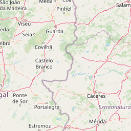
Serra de São Mamede Natural Park is situated entirely within the Portalegre District of Portugal. Regional records clarify the administrative relationships of an inland, non-transboundary protected area.
- Countries
- Portugal
- Regions
- Portalegre District
- Primary location
- Portalegre District
- Geographic setting
- Inland
Boundary and coordinates
A 560.6 km² outline with spatial context
Serra de São Mamede Natural Park mapped boundary and area
Parque Natural da Serra de São Mamede is a terrestrial protected landscape with a stated area of 560.6 km²; its single boundary geometry covers approximately 560.008 km² and measures 177.429 km around, closely tracking the source area. The calculated perimeter remains distinct because no source perimeter or separate land and marine allocations are stored.
- Boundary area
- 560 km²
- Boundary perimeter
- 177.4 km
- Northernmost point
- 39.5842° N
- Southernmost point
- 39.1194° N
- Easternmost point
- 7.1322° W
- Westernmost point
- 7.5628° W
- Geographic centre
- 39.3642° N, 7.3678° W
- North–south span
- 51.6 km
- East–west span
- 37.1 km
Elevation and terrain
Mountain relief metrics and recorded natural water and peak features
Serra de São Mamede Natural Park Terrain and Elevation Geography
Review the recorded elevation summit reaching 1025 meters across this mountain park terrain. Examine the structured cards detailing internal streams, peaks, springs, and viewpoints.
- Maximum elevation
- 1,025 m
Selected named natural features
Streams
Ribeira de Galegos
Islands
Tomada de água
Viewpoints
Castelo
Natural springs
Fonte da Raposa
Cave entrances
Gruta da Ermida de Nossa Senhora da Lapa
Environmental setting
Temperate and Mediterranean forest zones across mountain relief and terrain
Serra de São Mamede Natural Park Environmental Classifications and Physical Setting
Recorded landscape features, climate zones, and forest cover classifications form complementary ways to read the physical setting of Serra de São Mamede Natural Park. Stored categories connect directly to relevant atlas destinations across the protected area.
- Relief
- Mountain
- Climate
- Mediterranean
- Water
- Minor water
- Forest cover
- Mostly forested
- Seasonality
- Year-round
Landscape features
Mountains · Cliffs · Forest
Habitat types
Temperate broadleaf forest · Mediterranean forest
Park atlas
Compare protected areas, regional geography, and the diverse landscapes surrounding Serra de São Mamede Natural Park.
Discover Other Protected Areas & National Parks Near Serra de São Mamede Natural Park
Beyond Serra de São Mamede Natural Park, discover other protected areas, regional parks, and diverse landscapes within Portugal's Alentejo region and adjacent territories. This geographic view enables structured comparison of unique protected landscapes, tracing environmental transitions, and understanding wider conservation efforts.
Nature reservePortugal
73 km away#1 closest
North

Serra da Estrela Natural Park: Glacial Terrain and Highest Peaks in Portugal
Explore the dramatic geography of this nature reserve.
Serra da Estrela Natural Park is a significant protected landscape in Portugal, celebrated for containing the nation's highest peak and exceptional Quaternary glacial formations. The park's terrain includes dramatic valleys carved by ice, numerous glacial lakes, and a stark alpine plateau around Torre. This nature reserve preserves a unique environment shaped by both geological history and traditional pastoralism, offering rich mapped context for understanding Portugal's mountainous geography and protected areas.
- Area
- 891.32 km²
- Established
- 1976
- IUCN
- V
- Visitors
- 7.6K annual
Protected landscapePortugal
88 km away#2 closest
West
Aire and Candeeiros Ranges Natural Park: Protected Landscape and Regional Geographic Context
Explore the mapped boundaries and natural landscape of this Portuguese protected area.
Understand the Aire and Candeeiros Ranges Natural Park as a key protected landscape in Portugal. This page offers detailed geographic information, focusing on the park's mapped boundaries and its intrinsic connection to the surrounding regional geography. It serves as a portal for atlas exploration, providing structured data for users interested in the specific protected area and its landscape characteristics within the Iberian Peninsula.
- Area
- 383.93 km²
- Established
- 1979
- IUCN
- V
- Visitors
- 31.9K annual
National parkExtremadura
110 km away#3 closest
Northeast

Monfragüe National Park: Dramatic Cliffs, Raptor Haven, and Extremadura's Protected Landscape
Discover its mapped terrain and unique geography in Spain.
Monfragüe National Park, situated in Extremadura, Spain, offers a compelling study in protected landscape geography. The park's identity is shaped by its formidable cliffs and river valleys carved by the Tagus, providing critical nesting grounds for European raptors. This MoriAtlas entry details the park's mapped boundaries and its significance as a vital protected area within the region. Users can explore the specific natural terrain and regional context that establish Monfragüe as a unique protected territory.
- Area
- 179 km²
- Established
- 2007
- IUCN
- II
- Visitors
- 331.8K annual
National parkSpain
About 117 km away#4 closest
Northeast
Monfragüe National Park: Protected Landscape Atlas of Spanish Raptor Colonies
Explore mapped terrain and regional geography within this Spanish National Park.
As a national park in Spain's Extremadura region, Monfragüe National Park offers a distinct protected landscape shaped by the Tagus River and dramatic limestone cliffs. It is globally recognized for its exceptional birdlife, especially its large griffon vulture colonies and populations of Spanish imperial eagles, making it a significant site for ecological study and atlas-based exploration of protected areas. The park's landscape, characterized by Mediterranean woodlands and rugged terrain, provides crucial habitat and a unique geographic context for understanding Iberian Peninsula conservation.
- IUCN
- II
- Scope
- Terrestrial
Protected landscapeBeja District
146 km away#5 closest
South
Guadiana Valley Natural Park: Protected Landscape Discovery in Beja District
Explore its mapped geography and protected land context.
Guadiana Valley Natural Park is identified as a protected landscape, providing a specific focus for geographic study and map-based exploration. This entry details the park's unique protected-area status and its contextual placement within the expansive Beja District of southern Portugal. Understand the mapped boundaries and landscape features that define this area, serving as a key point for regional geographic understanding on MoriAtlas.
- Area
- 697 km²
- Established
- 1995
- IUCN
- V
- Visitors
- 749 annual
Protected landscapePortugal
150 km away#6 closest
Southwest
Arrábida Natural Park: Protected Landscape Atlas and Geographic Context in Portugal
Mapped boundaries of this key Portuguese protected area.
Arrábida Natural Park is presented here as a significant protected landscape, offering rich details for geographic exploration and atlas-based research. Users can investigate its specific mapped boundaries, understand its environmental setting within Portugal, and utilize this data for comparative analysis of protected areas. This resource focuses on the park's inherent geographic identity and its role as a defined natural landscape.
- Area
- 176.41 km²
- Established
- 1976
- IUCN
- V
- Visitors
- 23.1K annual
Protected landscapeLisbon District
170 km away#7 closest
West
Sintra-Cascais Natural Park: Mapped Protected Landscape in Lisbon District, Portugal
Explore Atlantic coast geography and historic palatial terrain.
The Sintra-Cascais Natural Park is a designated protected landscape in Portugal's Lisbon District, renowned for its fusion of natural beauty and historical architecture. This page offers an atlas-style exploration of its mapped boundaries, showcasing the unique Serra de Sintra mountain range meeting the Atlantic coast. Discover the protected area's geographic features, from its lush forested slopes crowned with iconic palaces to the dramatic cliffs and beaches of Cabo da Roca, providing essential context for understanding this distinctive Portuguese natural landscape.
- Area
- 144.51 km²
- Established
- 1981
- IUCN
- V
- Visitors
- 43.5K annual
Biosphere reserveExtremadura
About 176 km away#8 closest
East
La Siberia Biosphere Reserve: Mapped Geography and Protected Lands of Extremadura
A study of reservoir coastlines and Mediterranean serranías
La Siberia Biosphere Reserve offers a deep look into the rural landscape of Extremadura, Spain. Characterized by five major reservoirs and vast Mediterranean oak dehesas, the area provides essential habitat for raptors and preserves significant prehistoric rock art within its complex serranía topography. Explore the geographic boundaries and water-dominated landscape of this distinct inland region.
- Area
- 2,836.7 km²
- Established
- 2019
- Relief
- Mountain
- Climate
- Mediterranean
MoriAtlas Explorer
Continue Exploring the Geography of Serra de São Mamede Natural Park
Deepen your understanding of Serra de São Mamede Natural Park by exploring its specific geographic context and protected landscape features. This structured atlas approach allows for detailed investigation of its unique terrain, the confluence of its ecosystems, and its relationship with Portalegre District. Continue your discovery to grasp the full atlas value of this important natural area and its place within the mapped geography of Portugal.
Browse next
Global natural geography
Explore related park routes
Explore MoriAtlas Global ParksBrowse All MoriAtlas ParksGlobal Park Map DiscoveryMoriAtlas: Browse All CountriesBrowse All MoriAtlas ContinentsNational Park Environment AtlasGrand Canyon National Park AtlasYellowstone National Park AtlasYosemite National Park Atlas and GeographySerengeti National Park AtlasGalápagos National Park Protected LandscapeBanff National Park Geography and AtlasKruger National Park Atlas EntryUluṟu-Kata Tjuṯa National Park AtlasExplore Uluru-Kata Tjuta National Park GeographyPlitvice Lakes National Park AtlasFiordland National Park Protected LandscapeGreat Smoky Mountains National Park AtlasAfghanistan National Parks and Protected AreasAlbania National Parks and Protected AreasAlgeria National Parks and Protected AreasAmerican Samoa National Parks and Protected AreasAndorra National Parks and Protected AreasAngola National Parks and Protected AreasAntarctica National Parks and Protected AreasAntigua and Barbuda Park List