Mori Atlas logo
National parkSerranía de Macuira

Discover the protected land and natural terrain of this unique Colombian national park.

Serranía de Macuira National Park: Mapped Boundaries and La Guajira Regional Geography

(Parque Nacional Natural Macuira)

Serranía de Macuira National Park represents a vital protected area within the La Guajira region of Colombia. This page provides detailed geographic context, focusing on the park's mapped boundaries and its significance as a natural landscape. Explore the terrain and regional geography to understand Serranía de Macuira's place within the atlas of protected lands.

Mountain RangesCloud ForestsDesert OasisEndemic SpeciesNational ParksCaribbean Colombia

Serranía de Macuira

National park

Park overview

Structured park overview, official facts, and landscape profile for Serranía de Macuira

Serranía de Macuira park facts, protected area profile, and essential visitor context
Review the core facts for Serranía de Macuira, including designation, size, terrain, visitor scale, habitats, and operating context in one park-focused overview.

About Serranía de Macuira

Serranía de Macuira rises dramatically from the flat desert landscape of the La Guajira peninsula in northern Colombia, forming a mountainous island of green amid the brown expanse of one of the continent's most arid regions. The range sits within the municipality of Uribia, positioned roughly 10 kilometers from the Caribbean coast and separated from the major mountain systems of Colombia by hundreds of kilometers of desert and lowland terrain. This isolation has allowed the development of a unique ecological community that exists nowhere else on Earth. The mountains consist of three distinct massifs that are geologically interconnected but form separate visual peaks, with Cerro Paluou reaching 864 meters and Cerro de Jibome reaching 753 meters. The protected area encompasses approximately 250 square kilometers of this mountainous terrain, preserving not only the forest ecosystems but also the water catchments that sustain the local Wayuu indigenous communities who have historically depended on these mountains for freshwater. The area was established as a protected National Natural Park to preserve this irreplaceable mountain ecosystem and the species that depend on it.

Quick facts and research context for Serranía de Macuira

Serranía de Macuira is located in the municipality of Uribia in La Guajira Department, approximately 10 kilometers inland from the Caribbean Sea. The mountain range spans roughly 35 kilometers in length and 10 kilometers in width, covering an area of about 250 square kilometers. It consists of three interconnected mountain massifs, with Cerro Paluou as the highest peak at 864 meters above sea level. Despite being surrounded by desert, the range supports cloud forest ecosystems due to moisture from trade winds. The area is protected as a National Natural Park and is notable for endemic species including the frog Allobates wayuu.

Park context

Deeper park guide and search-rich context for Serranía de Macuira

Serranía de Macuira history, landscape, wildlife, and travel context
Explore Serranía de Macuira through its history, landscape character, ecosystems, wildlife, conservation priorities, cultural context, and seasonal travel timing in a structured park guide built for atlas discovery and search intent.

Why Serranía de Macuira stands out

Serranía de Macuira is best known for its extraordinary ecological paradox: a cloud forest ecosystem existing within a desert environment. The range harbors dwarf trees and cloud forest vegetation that thrives on moisture carried by trade winds from the Caribbean, creating a biodiversity hotspot that is completely isolated from the Sierra Nevada de Santa Marta and the Eastern Ranges of the Colombian Andes. This unique combination of high humidity microclimates amid arid surroundings makes it a singular natural laboratory for understanding how isolated mountain ecosystems function in tropical desert contexts.

Serranía de Macuira history and protected-area timeline

Serranía de Macuira was designated as a National Natural Park to protect the unique cloud forest ecosystem that exists within the La Guajira Desert. The establishment of formal protection reflects recognition of the range's ecological significance as an isolated biodiversity hotspot containing species found nowhere else on the planet. The area holds particular cultural importance for the Wayuu people, the indigenous inhabitants of the La Guajira peninsula, who have historically relied on the mountain's water sources and unique microclimate for survival in an otherwise challenging desert environment.

Serranía de Macuira landscape and geographic character

The landscape of Serranía de Macuira presents one of Colombia's most striking topographic contrasts. The mountain range rises abruptly from the flat desert plains, forming a series of rugged peaks and ridgelines that create a complex terrain of slopes, valleys, and summits. The three main massifs are interconnected by lower ridges, creating a unified mountain system despite their individual identities. Cerro Paluou, the highest point, stands at 864 meters and offers commanding views over the surrounding desert. The slopes of the range feature a combination of rocky outcrops, forested areas, and steep-sided valleys that channel the moisture-laden trade winds into the interior of the range. This terrain creates multiple microhabitats, from the exposed rocky ridges to the sheltered forested slopes where cloud formation occurs.

Serranía de Macuira ecosystems, habitats, and plant life

The nature of Serranía de Macuira is defined by a remarkable ecological phenomenon: the presence of cloud forest and dwarf tree ecosystems in the middle of a desert. This occurs because the trade winds blowing from the Caribbean Sea collide with the mountain slopes, causing moisture to condense and form persistent cloud cover at higher elevations. The resulting humidity supports vegetation types that would be impossible at these latitudes without the mountain's elevation and exposure. The forests that develop are characterized by relatively small trees, often described as dwarf or elfin forest, adapted to the constant moisture and exposed conditions. These cloud forests represent a distinct vegetation formation that exists in sharp contrast to the surrounding desert scrub and dry forest of the lowlands.

Serranía de Macuira wildlife and species highlights

Serranía de Macuira supports a distinctive fauna adapted to its unique mountain forest environment. The range is notable as the only known location for the frog species Allobates wayuu, an endemic amphibian that is found exclusively within the boundaries of the Macuira mountains. This single-site endemism underscores the importance of the range as a center of biodiversity uniqueness. Beyond this flagship species, the cloud forests and dwarf tree habitats support a variety of bird species, small mammals, and invertebrates that have adapted to the humid forest conditions. The combination of isolation from major mountain systems and the unique habitat conditions created by the cloud forest environment has allowed the evolution of a distinct fauna community.

Serranía de Macuira conservation status and protection priorities

Serranía de Macuira represents a conservation priority of national and international significance due to its unique ecological character. The protected area preserves an isolated cloud forest ecosystem that exists as a biodiversity island within the larger La Guajira Desert, making it irreplaceable in conservation terms. The presence of endemic species such as Allobates wayuu further elevates the conservation importance of the range, as these species exist nowhere else and depend entirely on the preservation of their specific habitat. The park also provides essential ecosystem services by capturing and retaining moisture that would otherwise not be available in this arid region, supporting both ecological processes and the water needs of local communities.

Serranía de Macuira cultural meaning and human context

Serranía de Macuira holds deep cultural significance for the Wayuu people, the indigenous communities that have inhabited the La Guajira peninsula for centuries. The mountains represent one of the few reliable sources of freshwater in the otherwise arid region, making the range historically important for the survival and settlement patterns of Wayuu communities. The relationship between the Wayuu and the Macuira mountains exemplifies how isolated mountain ecosystems in desert regions can be central to human habitation and cultural practices, contrasting with the more commonly understood patterns of settlement in wetter mountain environments.

Top sights and standout views in Serranía de Macuira

The defining highlight of Serranía de Macuira is its extraordinary ecological setting: a mountain range of cloud forests and dwarf trees rising from desert, creating a green island in a sea of brown. The three massifs of the range offer distinct visual character, with Cerro Palauou providing the highest summit experience. The endemic frog Allobates wayuu represents a unique biological treasure found only within these mountains. The view from the mountain slopes overlooking the surrounding desert plains provides one of the most dramatic landscape contrasts in Colombia.

Best time to visit Serranía de Macuira

Serranía de Macuira can be visited year-round, though the dry season from December through April typically offers the most comfortable conditions for exploration. The cloud forest conditions are largely driven by the persistent trade winds rather than seasonal rainfall patterns, meaning the characteristic moisture and fog are present throughout the year. Visitors interested in experiencing the full visual impact of the desert-to-forest contrast may find the clearer atmospheric conditions of the dry season particularly rewarding for landscape photography and sightseeing.
Park location guide

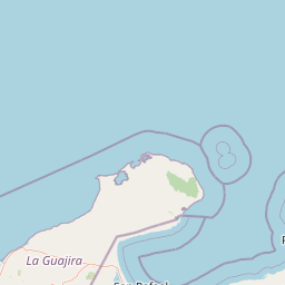
Geography guide, regional context, and park location map for Serranía de Macuira

Serranía de Macuira park geography, regions, and map view in Colombia
Understand where Serranía de Macuira sits in Colombia through a broader geographic reading of the surrounding landscape, nearby location context, and its mapped position within the national park landscape.

How Serranía de Macuira fits into Colombia

Colombia is a presidential republic located in the northern part of South America. It spans approximately 1.14 million km² and has a population of around 52 million. The country features the Andes mountain range, extensive Amazon rainforest, and coastal regions on both the Caribbean and Pacific. Spanish is the official language, and Bogotá serves as the capital and largest city.

Wider geography shaping Serranía de Macuira in Colombia

Colombia is located in the northwestern part of South America, bordering the Caribbean Sea to the north and the Pacific Ocean to the west. Its mainland neighbors are Venezuela to the east, Brazil to the southeast, Peru and Ecuador to the south and southwest, and Panama to the northwest. The terrain is diverse, featuring the Andes mountain range in the west, Amazon rainforest in the south and east, and coastal plains along both oceans.

Map view of Serranía de Macuira

Use this park location map to pinpoint Serranía de Macuira in Colombia, understand its exact geographic position, and read its mapped placement within the surrounding landscape more clearly.

Pigeon | © OpenStreetMap contributors

Location context for Serranía de Macuira

La Guajira
Park atlas

Trace the regional spread of protected landscapes, comparing mountain ecosystems and desert oases beyond this isolated cloud forest.

Discover Nearby National Parks and Protected Areas around Serranía de Macuira in Caribbean Colombia
Continue your exploration from Serranía de Macuira by browsing nearby national parks and other protected areas across northern Colombia. Compare the unique geographic settings, from coastal ecosystems to mountain ranges and other desert environments, enriching your understanding of regional conservation landscapes.
Watercolor painting of a beach with cacti, sandy shore, and coastal waters
National parkLa Guajira

Bahía Portete, Kaurrele National Natural Park: Mapped Protected Landscape in La Guajira

Explore National Park Geography and Boundaries

Bahía Portete, Kaurrele National Natural Park represents a key protected landscape entity within the La Guajira region of Colombia. This national park's defined geographic scope and mapped protected area status provide a solid foundation for atlas-driven exploration. Understand its role in the regional geography, trace its boundaries, and discover the unique landscape characteristics that define this significant protected territory through structured data.

Area
140.8 km²
Established
2014
Relief
Lowland
Climate
Arid
National parkFalcón State

Médanos de Coro National Park: Venezuela's Unique Arid Landscape and Protected Dune System

Explore the mapped geography of this coastal desert in Falcón State.

Médanos de Coro National Park represents a remarkable protected area within Venezuela's Falcón State, renowned for its spectacular and active sand dune systems. This national park encompasses approximately 91 square kilometers of unique terrain, including large sand formations, salt marshes, and mangrove swamps, contributing to its designation as a key conservation site for arid coastal ecosystems. Users can explore the park's distinctive landscape, understand its geographic context, and discover the patterns of wind-sculpted dunes that define this Venezuelan national park.

Area
91 km²
Established
1974
IUCN
II
Relief
Lowland
Wildlife reserveColombia

Los Flamencos Sanctuary Wildlife Reserve: Geographic Context and Protected Landscape

Mapped boundaries within Colombia's natural geography.

Los Flamencos Sanctuary is a designated wildlife reserve contributing to the protected landscapes of Colombia. This entry provides a detailed look at its geographic setting and mapped features, crucial for understanding its ecological significance and atlas placement. Explore the protected area's context within the diverse geography of South America, offering a structured perspective for landscape discovery.

Area
0.077 km²
Established
1977
Relief
Lowland
Climate
Tropical
Watercolor painting of a landscape featuring green trees, hills, and cacti under a light blue sky
National parkCuracao

Christoffelpark National Park: Curacao's Volcanic Terrain and Protected Landscape Atlas

Explore mapped boundaries and unique dry forest ecosystems.

Christoffelpark represents Curacao's most vital protected natural area, offering a deep dive into its unique geography and landscape. This national park preserves the island's highest peak, Christoffelberg, alongside distinctive dry forest ecosystems, endemic species, and the remnants of colonial plantations. Explore the mapped terrain, understand the regional context, and appreciate the rich natural and cultural heritage that defines this important protected landscape on Curacao.

Area
10.4 km²
Established
1978
IUCN
II
Relief
Mixed relief
National parkLara State

Cerro Saroche National Park: A National Park within Lara State's Geography

Explore the protected landscape and mapped boundaries.

Cerro Saroche National Park in Lara State, Venezuela, is a distinct protected area offering a valuable perspective for geographic and atlas exploration. This page provides essential details about its identity as a national park, highlighting its place within the regional landscape. Understanding Cerro Saroche National Park helps in appreciating the distribution of protected lands and their geographical significance across Venezuela.

Area
322.94 km²
Established
1989
IUCN
II
Relief
Mountain
National park

Tayrona National Natural Park: Protected Landscape and Biodiversity Atlas

Explore its unique geography, mapped terrain, and vital ecosystems.

Tayrona National Natural Park serves as a prime example of a protected natural landscape at the confluence of major geographic features. Situated in Colombia's Caribbean coast, it is defined by the foothills of the Sierra Nevada de Santa Marta rising towards the sea, creating a distinct regional geography. Users can explore its mapped boundaries, understand its ecological gradient from coastal zones to montane forests, and appreciate its significance as a vital conservation area with rich biodiversity.

Area
180 km²
Established
1964
IUCN
II
Visitors
545.8K annual
National parkVenezuela

Dinira National Park: Protected Watershed and Andean Mountain Landscape

Explore its rugged terrain and páramo ecosystem.

Dinira National Park is a significant protected area in Venezuela, covering rugged Andean terrain vital for watershed protection. This national park features dramatic mountain landscapes, including the Humocaro Mountains and the Los Nepes páramo zone, supporting diverse cloud forest and high-altitude ecosystems. Understanding Dinira National Park offers insight into the geographic context of the Cordillera de Mérida and its hydrological importance.

Area
453.28 km²
Established
1988
IUCN
II
Relief
Mountain
National parkLara State

Yacambú National Park National Park: Protected Cloud Forest Landscape in Lara State

Mapped terrain and significant orchid diversity in Venezuela's Andean foothills.

Yacambú National Park is a significant national park in Venezuela's Lara State, protecting crucial humid cloud forest ecosystems in the Andean foothills. The park's terrain is defined by the mountainous topography of the Portuguesa Mountain Range, supporting a rich diversity of flora, including numerous orchid species. Its role in watershed protection for nearby regions underscores its importance as a conserved natural landscape with vital ecological functions.

Area
146 km²
Established
1962
IUCN
II
Relief
Mountain

Common questions about visiting, size, designation, and location context for Serranía de Macuira

Serranía de Macuira FAQs for park facts, access, geography, and protected area context
Find quick answers about Serranía de Macuira, including protected-area facts, park geography, trail and visitor context, and how the park fits into its surrounding country and regional landscape.
MoriAtlas Explorer

Continue Your Protected Areas Search Across the Global Atlas

Deepen your exploration by continuing the structured search for national parks and protected areas worldwide. Utilize the comprehensive filtering capabilities to compare different conservation landscapes and refine your understanding of global park geography. Discover more about the distribution and characteristics of protected natural areas.

Global natural geography