Mori Atlas logo
Wildlife reserveLos Flamencos Sanctuary

Understand the mapped boundaries and geographic context of this protected natural area.

Los Flamencos Sanctuary: Colombia's Wildlife Reserve for Protected Landscape Discovery

(Santuario de Fauna y Flora Los Flamencos)

Los Flamencos Sanctuary stands as a key protected area within Colombia, identified as a wildlife reserve dedicated to conserving its natural heritage. This page offers an atlas-focused exploration of its geographic scope, mapped boundaries, and role as a protected landscape. Delve into the specific natural context of Los Flamencos Sanctuary, understanding its place within the broader geography of Colombia for detailed map-based discovery.

wetland sanctuarycolonial waterbirdsAmerican flamingoCaribbean coastcoastal lagoonbirdwatching

Los Flamencos Sanctuary

Wildlife reserve

Park overview

Structured park overview, official facts, and landscape profile for Los Flamencos Sanctuary

Los Flamencos Sanctuary park facts, protected area profile, and essential visitor context
Review the core facts for Los Flamencos Sanctuary, including designation, size, terrain, visitor scale, habitats, and operating context in one park-focused overview.

About Los Flamencos Sanctuary

Los Flamencos Sanctuary occupies a distinctive ecological niche on Colombia's northern Caribbean coast, where the Guajira Peninsula extends into the Caribbean Sea creating a complex interface between arid continental terrain and productive coastal wetlands. The protected area was formally designated as a wildlife sanctuary in 1977, placing it among the earliest of Colombia's national protected areas established during the country's expanding environmental protection initiatives of the late 1970s. The sanctuary's boundary encompasses several interconnected lagoon systems and marsh complexes that receive freshwater inflow from the Tapias River while maintaining direct connection to the Caribbean through coastal channels. This hydrological setting creates a brackish environment ideal for supporting the filter-feeding organisms that form the primary diet of American flamingoes. The surrounding landscape transitions from the wetland margins into xerophytic scrub characterized by drought-resistant vegetation adapted to the peninsula's semi-arid climate, where precipitation is limited and evaporation rates are high. This spatial arrangement, where highly productive wetlands are embedded within an arid matrix, makes the sanctuary ecologically significant as a concentrated oasis of biodiversity in a region where suitable bird habitat is otherwise limited. The sanctuary's management under SINAP ensures protection of both the aquatic feeding and nesting areas and the adjacent terrestrial habitats that support additional bird species.

Quick facts and research context for Los Flamencos Sanctuary

Los Flamencos Sanctuary covers 7.682 hectares on Colombia's Guajira Peninsula in the Caribbean Region, established in 1977 as a fauna and flora sanctuary managed under Colombia's National System of Protected Areas (SINAP). The sanctuary is positioned between the fishing community of Camarones and the Tapias River, protecting a network of coastal lagoons and marshes that serve as crucial habitat for colonial waterbirds. The American flamingo represents the flagship species, with nesting mounds documented at heights reaching 60 centimeters. Beyond flamingoes, the sanctuary supports diverse bird communities including roseate spoonbills, great egrets, and laughing gulls, while the surrounding xerophytic scrubland provides territory for endemic species such as the buffy hummingbird, white-whiskered spinetail, Tocuyo sparrow, and vermilion cardinal.

Park context

Deeper park guide and search-rich context for Los Flamencos Sanctuary

Los Flamencos Sanctuary history, landscape, wildlife, and travel context
Explore Los Flamencos Sanctuary through its history, landscape character, ecosystems, wildlife, conservation priorities, cultural context, and seasonal travel timing in a structured park guide built for atlas discovery and search intent.

Why Los Flamencos Sanctuary stands out

Los Flamencos Sanctuary is renowned primarily for its American flamingo colonies, which represent one of the most significant nesting populations of this species in northern South America. The sanctuary provides protected breeding and feeding grounds where these distinctive pink wading birds construct mud-mound nests that can reach 60 centimeters in height. Beyond flamingoes, the wetland complex is celebrated for supporting exceptional concentrations of colonial waterbirds, making it a premier destination for birdwatching in the Caribbean region. The juxtaposition of vibrant birdlife against the backdrop of semi-arid Guajira desert creates a visually striking landscape that distinguishes this sanctuary from other coastal protected areas in Colombia.

Los Flamencos Sanctuary history and protected-area timeline

Los Flamencos Sanctuary was established in 1977 as part of Colombia's growing network of protected areas during a period of increasing environmental awareness and institutional capacity for conservation. The designation as a Santuario de Fauna y Flora (Fauna and Flora Sanctuary) reflected the Colombian government's recognition of the site as a critical habitat for significant wildlife populations, particularly colonial waterbirds. The timing of establishment coincided with broader regional conservation efforts in the Caribbean Natural Region of Colombia, where the unique combination of coastal ecosystems and endemic species required formal protection mechanisms. The sanctuary's creation also acknowledged the importance of the Guajira Peninsula's wetlands as a natural resource within one of Colombia's most culturally and environmentally distinct regions. Since its designation, the sanctuary has operated under the framework of Colombia's National System of Protected Areas (SINAP), providing institutional continuity for ongoing conservation efforts.

Los Flamencos Sanctuary landscape and geographic character

The physical landscape of Los Flamencos Sanctuary consists of a coastal wetland complex situated within the broader context of the Guajira Peninsula's semi-arid terrain. The sanctuary protects a series of interconnected lagoons, estuaries, and marshes including Manzanillo, Laguna Grande, Ciénaga del Navío Quebrado, and Tocoromanes, all of which form part of the hydrological system associated with the Tapias River. These water bodies create a mosaic of open water, submerged vegetation zones, and muddy margins that provide ideal foraging habitat for wading birds. The surrounding terrain is characterized by xerophytic scrub vegetation, indicating the broader arid conditions of the peninsula where rainfall is sparse and soils are generally nutrient-poor. The transition between the wetland areas and the dry scrubland creates a visually dramatic landscape where the pink coloration of flamingoes stands out against both the blue water and the brownish scrub backdrop. The coastal position also means the landscape is influenced by tidal cycles, adding rhythmic variation to the visual character of the sanctuary's waterways and mudflats.

Los Flamencos Sanctuary ecosystems, habitats, and plant life

The ecological character of Los Flamencos Sanctuary is defined by its coastal lagoon and marsh ecosystems, which function as highly productive habitats supporting diverse bird communities. The brackish water conditions created by the mixing of fresh water from the Tapias River with saltwater from the Caribbean support abundant populations of crustaceans, mollusks, and small fish that form the dietary foundation for colonial waterbirds. The American flamingo particularly benefits from these conditions, as its specialized filter-feeding method relies on the rich invertebrate communities inhabiting the shallow lagoon waters. The surrounding xerophytic scrubland represents a distinct habitat type characterized by drought-adapted plant species capable of surviving in the peninsula's semi-arid climate. This scrub ecosystem supports a different community of bird species adapted to drier conditions, including several endemic forms that are restricted to the Caribbean coast of northern Colombia and adjacent Venezuela. The combination of wetland and dry scrub within a relatively small protected area creates notable ecological diversity and makes the sanctuary an important site for regional biodiversity conservation.

Los Flamencos Sanctuary wildlife and species highlights

The wildlife community of Los Flamencos Sanctuary is dominated by colonial waterbirds, with the American flamingo serving as the most prominent species and primary focus of the sanctuary's conservation purpose. These large pink wading birds nest in the shallow lagoon areas, constructing characteristic mud-mound nests that can reach 60 centimeters in height, elevating the eggs above the water level during periods of higher water. The sanctuary supports significant populations of several other wading bird species including roseate spoonbills, whose distinctive spatula-shaped bills allow them to sweep through shallow waters feeding on small organisms, and great egrets, which hunt fish and invertebrates in the lagoon margins. Laughing gulls represent a common presence along the water's edge and are particularly visible at sunset when they gather in groups over the wetland waters. The xerophytic scrub surrounding the wetlands supports a different suite of bird species including the small buffy hummingbird, the ochre-colored white-whiskered spinetail, the locally distributed Tocuyo sparrow, and the striking vermilion cardinal with its brilliant red plumage. This combination of wetland-dependent and scrub-dwelling species creates a diverse bird community within a relatively compact area.

Los Flamencos Sanctuary conservation status and protection priorities

Los Flamencos Sanctuary plays a significant conservation role in the Caribbean Region of Colombia by protecting critical nesting and feeding habitat for colonial waterbirds in a region where such habitats are limited. The designation as a wildlife sanctuary since 1977 has provided institutional protection for the wetland complex, shielding it from development pressures that could otherwise transform the lagoon and marsh areas. The sanctuary's inclusion within Colombia's National System of Protected Areas (SINAP) ensures ongoing management and monitoring of the site, though the small area of 7.682 hectares means conservation focus is concentrated on a specific zone rather than a broad landscape. The protection of the American flamingo population is particularly important given the species' relatively limited breeding distribution in northern South America and the vulnerability of colony sites to disturbance. Beyond the flagship flamingo species, the sanctuary's conservation value extends to the diverse community of shorebirds, waterfowl, and scrubland birds that depend on the different habitat types within and adjacent to the protected area.

Los Flamencos Sanctuary cultural meaning and human context

Los Flamencos Sanctuary is situated within the cultural landscape of the Guajira Peninsula, a region characterized by the presence of the Wayuu indigenous people and a strong fishing heritage along the Caribbean coast. The sanctuary's location between the small fishing village of Camarones and the Tapias River places it within a landscape where human communities have historically interacted with the wetland environment. Fishing remains an important local activity, and the sustainable use of coastal and lagoon resources has traditionally supported the livelihood of communities in this part of La Guajira Department. The sanctuary's establishment in 1977 represented a formal recognition that the wetland areas held value beyond their immediate economic use, providing ecological services and biodiversity conservation benefits that warranted protected status. While the sanctuary itself is managed primarily for wildlife conservation, its existence contributes to the broader cultural identity of the region as a place where natural and cultural heritage intersect.

Top sights and standout views in Los Flamencos Sanctuary

The primary highlight of Los Flamencos Sanctuary remains the spectacular concentration of American flamingoes that nest and feed within its protected lagoon systems, with nesting mounds reaching impressive heights of up to 60 centimeters. The sanctuary offers exceptional birdwatching opportunities, providing observations of species such as roseate spoonbills, great egrets, and large flocks of laughing gulls in a compact and accessible setting. The visual contrast between the pink flamingoes, blue lagoon waters, and the brown xerophytic scrub of the surrounding peninsula creates a distinctive and memorable landscape. The sanctuary's position on Colombia's Caribbean coast provides an accessible destination for visitors interested in observing tropical wetland ecosystems in a region where such habitats are otherwise limited by the peninsula's semi-arid conditions. The combination of colonial waterbird colonies, coastal lagoon scenery, and proximity to the fishing community of Camarones offers a integrated experience combining natural spectacle with the cultural context of the Guajira coast.

Best time to visit Los Flamencos Sanctuary

The optimal period for visiting Los Flamencos Sanctuary aligns with the dry season conditions typical of the Guajira Peninsula, when lower water levels in the lagoons concentrate fish and invertebrates in shallower areas, creating ideal foraging conditions for flamingoes and other waterbirds. The dry season generally extends from December through April, offering visitors the best chance to observe active feeding and nesting behavior among colonial waterbirds. During this period, the semi-arid landscape surrounding the sanctuary is also at its most characteristic, with the contrast between the wetland and the dry scrub particularly pronounced. The cooler months from December to February may offer more comfortable conditions for daytime exploration, though the Guajira Peninsula remains warm throughout the year. Visitors interested in witnessing the full spectacle of the flamingo colonies should consider timing their visit to coincide with morning or late afternoon hours when bird activity around the lagoon margins is highest.

Park location guide

Geography guide, regional context, and park location map for Los Flamencos Sanctuary

Los Flamencos Sanctuary park geography, regions, and map view in Colombia
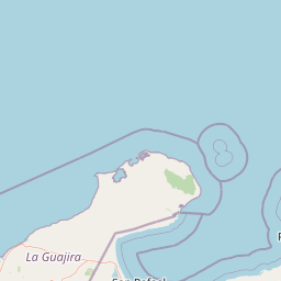
Understand where Los Flamencos Sanctuary sits in Colombia through a broader geographic reading of the surrounding landscape, nearby location context, and its mapped position within the national park landscape.

How Los Flamencos Sanctuary fits into Colombia

Colombia is a presidential republic located in the northern part of South America. It spans approximately 1.14 million km² and has a population of around 52 million. The country features the Andes mountain range, extensive Amazon rainforest, and coastal regions on both the Caribbean and Pacific. Spanish is the official language, and Bogotá serves as the capital and largest city.

Wider geography shaping Los Flamencos Sanctuary in Colombia

Colombia is located in the northwestern part of South America, bordering the Caribbean Sea to the north and the Pacific Ocean to the west. Its mainland neighbors are Venezuela to the east, Brazil to the southeast, Peru and Ecuador to the south and southwest, and Panama to the northwest. The terrain is diverse, featuring the Andes mountain range in the west, Amazon rainforest in the south and east, and coastal plains along both oceans.

Map view of Los Flamencos Sanctuary

Use this park location map to pinpoint Los Flamencos Sanctuary in Colombia, understand its exact geographic position, and read its mapped placement within the surrounding landscape more clearly.

Pigeon | © OpenStreetMap contributors

Location context for Los Flamencos Sanctuary

La Guajira Department
Park atlas

Map adjacent protected areas, comparing coastal wetland ecosystems and arid Guajira landscapes to extend your discovery from Los Flamencos Sanctuary.

Explore Nearby Protected Areas and National Parks Around Los Flamencos Sanctuary
Continue your exploration from Los Flamencos Sanctuary by browsing other protected areas and national parks that share similar wetland ecosystems or arid coastal geography on the Guajira Peninsula. This allows for a deeper atlas-style comparison of conservation landscapes, offering regional context and diverse natural features beyond the sanctuary's famous flamingo colonies.
National park

Tayrona National Natural Park: Protected Landscape and Biodiversity Atlas

Explore its unique geography, mapped terrain, and vital ecosystems.

Tayrona National Natural Park serves as a prime example of a protected natural landscape at the confluence of major geographic features. Situated in Colombia's Caribbean coast, it is defined by the foothills of the Sierra Nevada de Santa Marta rising towards the sea, creating a distinct regional geography. Users can explore its mapped boundaries, understand its ecological gradient from coastal zones to montane forests, and appreciate its significance as a vital conservation area with rich biodiversity.

Area
180 km²
Established
1964
IUCN
II
Visitors
545.8K annual
Watercolor painting of a beach with cacti, sandy shore, and coastal waters
National parkLa Guajira

Bahía Portete, Kaurrele National Natural Park: Mapped Protected Landscape in La Guajira

Explore National Park Geography and Boundaries

Bahía Portete, Kaurrele National Natural Park represents a key protected landscape entity within the La Guajira region of Colombia. This national park's defined geographic scope and mapped protected area status provide a solid foundation for atlas-driven exploration. Understand its role in the regional geography, trace its boundaries, and discover the unique landscape characteristics that define this significant protected territory through structured data.

Area
140.8 km²
Established
2014
Relief
Lowland
Climate
Arid
National parkMagdalena Department

Salamanca Island Road Park National Park: A UNESCO Biosphere Reserve of Coastal Wetlands and Mangroves

Explore its unique estuarine environment and abundant bird populations.

Salamanca Island Road Park, designated a National Park and UNESCO Biosphere Reserve, protects a crucial coastal wetland ecosystem in Colombia's Magdalena Department. Its landscape is defined by vast mangrove forests, tidal flats, and the unique meeting of the Magdalena River's fresh water with the Caribbean Sea's salinity. This park is a significant area for birdwatching, with hundreds of species inhabiting its estuarine environment, offering a key point of reference for understanding protected landscapes on the Caribbean coast.

Area
562 km²
Established
1964
IUCN
III
Relief
Lowland
National parkVenezuela

Sierra de Perijá National Park: Protected Area in Venezuela's Geographic Atlas

Explore its national park boundaries and regional landscape context.

Sierra de Perijá National Park is a designated national park in Venezuela, representing a significant protected landscape within the country. This entry facilitates detailed atlas exploration, allowing users to understand the park's precise geographic scope, its mapped boundaries, and its connection to the surrounding regional geography. Discover the core identity of this protected area and its value for geographic study and mapped landscape analysis.

Area
2,952.88 km²
Established
1978
IUCN
II
Relief
Mountain
National parkLa Guajira

Serranía de Macuira National Park: Protected Landscape and Regional Geography Atlas

Explore mapped boundaries of Serranía de Macuira.

Delve into the geography and protected status of Serranía de Macuira National Park, situated in the La Guajira region. This entity offers insight into the mapped terrain and the distribution of protected lands within Colombia. Understand its unique landscape context and its role within a broader geographic atlas.

Area
250 km²
Relief
Mountain
Climate
Arid
Access
Moderate access
National parkColombia

Rosario and San Bernardo Corals National Natural Park: Colombia's National Natural Park Protected Landscape

Explore the mapped geography and protected natural areas of this Colombian national park.

Delve into the geographical details and protected landscape identity of Rosario and San Bernardo Corals National Natural Park, a significant national park within Colombia. This resource provides a structured atlas view of its mapped boundaries and natural terrain, contributing essential context to the broader Colombian geography and its protected areas.

Area
1,200 km²
Established
1977
IUCN
II
Visitors
318.5K annual
Natural monumentColombia

Los Estoraques Unique Natural Area: Colombian Natural Monument of Eroded Pillars

Geographic Context and Landscape Atlas

Los Estoraques Unique Natural Area stands as a distinctive protected landscape within Colombia's Norte de Santander Department. This natural monument is renowned for its striking geological formations of eroded brownstone columns and pedestals, a unique erosional terrain set within the Andean foothills. The area's mapped boundaries encompass a complex ecosystem, bridging dry forest and cloud forest zones, offering significant value for understanding regional geography and the distribution of protected lands in South America.

Area
562 km²
Established
1988
IUCN
III
Relief
Mountain
National parkFalcón State

Médanos de Coro National Park: Venezuela's Unique Arid Landscape and Protected Dune System

Explore the mapped geography of this coastal desert in Falcón State.

Médanos de Coro National Park represents a remarkable protected area within Venezuela's Falcón State, renowned for its spectacular and active sand dune systems. This national park encompasses approximately 91 square kilometers of unique terrain, including large sand formations, salt marshes, and mangrove swamps, contributing to its designation as a key conservation site for arid coastal ecosystems. Users can explore the park's distinctive landscape, understand its geographic context, and discover the patterns of wind-sculpted dunes that define this Venezuelan national park.

Area
91 km²
Established
1974
IUCN
II
Relief
Lowland

Common questions about visiting, size, designation, and location context for Los Flamencos Sanctuary

Los Flamencos Sanctuary FAQs for park facts, access, geography, and protected area context
Find quick answers about Los Flamencos Sanctuary, including protected-area facts, park geography, trail and visitor context, and how the park fits into its surrounding country and regional landscape.
MoriAtlas Explorer

Continue Your Protected Areas Search Across the Global Atlas

Deepen your exploration by continuing the structured search for national parks and protected areas worldwide. Utilize the comprehensive filtering capabilities to compare different conservation landscapes and refine your understanding of global park geography. Discover more about the distribution and characteristics of protected natural areas.

Global natural geography