

Mori Atlas logo
National parkSheikh Badin National Park

Discover the rugged terrain, bird migration corridors, and semi-arid mountain geography of this Pakistani national park.

Sheikh Badin National Park: Protected Landscape at Pakistan's Sulaiman Mountain Edge

Sheikh Badin National Park represents a significant protected area within Pakistan, characterized by the rugged hills and valleys of the Sheikh Badin Hills, an eastern extension of the Sulaiman Mountains. This national park provides a unique semi-arid mountain landscape, serving as a vital transition zone at the edge of central Pakistan's geographical features. Explore the mapped boundaries and diverse terrain that define this important conservation landscape.

mountain protected areaSulaiman MountainsKhyber Pakhtunkhwabird migration corridorherpetofauna habitatsemi-arid mountains

Sheikh Badin National Park

National park

Park overview

Structured park overview, official facts, and landscape profile for Sheikh Badin National Park

Sheikh Badin National Park park facts, protected area profile, and essential visitor context

Review the core facts for Sheikh Badin National Park, including designation, size, terrain, visitor scale, habitats, and operating context in one park-focused overview.

About Sheikh Badin National Park

Sheikh Badin National Park occupies a strategically important position at the interface between the Sulaiman Mountains and the Indus River plains in northwestern Pakistan. The park's terrain consists primarily of the Sheikh Badin Hills, a series of rugged ridgelines and valleys that form an eastern extension of the greater Sulaiman range. This mountainous character distinguishes the park from the surrounding semi-arid plains and creates diverse microhabitats supporting varied wildlife.

The protected area was officially established in 2003, making it a relatively recent addition to Pakistan's network of national parks. The establishment reflected growing recognition of the need to conserve the unique ecological and cultural values of this mountainous region. The park straddles two administrative districts, Dera Ismail Khan and Lakki Marwat, encompassing both the core protected zone and surrounding community lands.

Beyond its ecological significance, the park holds cultural importance due to the presence of resident communities with deep historical roots. Mughal families settled in the area following the 1857 war of independence against British rule, while Syed families maintain lineage claims to Sheikh Abdul Qjilani, a prominent religious figure. These communities maintain traditional land-use practices that interweave with the park's ecological systems.

Quick facts and research context for Sheikh Badin National Park

Sheikh Badin National Park spans 15,540 hectares in the Sulaiman Mountain foothills of Khyber Pakhtunkhwa, Pakistan. Established in 2003, the park protects a mountainous landscape that forms an eastern extension of the Sulaiman range. The protected area supports 41 bird species, including 18 migratory species, and 23 herpetofauna species. The park lies at an ecological transition zone between mountain and plain ecosystems.

Protection and recognition

Documenting the terrestrial boundary scope and official designation history within regional conservation frameworks

Official Protection Status and Terrestrial Designation of Sheikh Badin National Park

Terrestrial conservation parameters define the official management framework and designated boundary scope of Sheikh Badin National Park. Verifying these documented designations provides baseline geographic context on the regional protection systems established to oversee this unique mountain habitat.

Protection details

Protection scope
Terrestrial
Transboundary protection
No
Park context

Deeper park guide and search-rich context for Sheikh Badin National Park

Sheikh Badin National Park history, landscape, wildlife, and travel context

Explore Sheikh Badin National Park through its history, landscape character, ecosystems, wildlife, conservation priorities, cultural context, and seasonal travel timing in a structured park guide built for atlas discovery and search intent.

Why Sheikh Badin National Park stands out

Sheikh Badin National Park is best known for its position at the eastern edge of the Sulaiman Mountains, where rugged hills and valleys create a distinctive mountainous landscape within central Pakistan. The park is notable for its diverse birdlife, particularly the presence of 18 migratory species among the 41 documented avifauna species, making it significant for seasonal bird observation. The reptile diversity is equally remarkable, with 21 documented reptile species including monitor lizards, pythons, and venomous snakes representing one of the more comprehensive herpetofauna assemblages in the region.

Sheikh Badin National Park history and protected-area timeline

Sheikh Badin National Park was established in 2003 as part of Pakistan's expanding network of protected areas. The creation of the park responded to growing environmental concerns about the ecological sensitivity of the Sulaiman Mountain foothills and the need to conserve biodiversity in a region experiencing increasing developmental pressures. Prior to formal protection status, the Sheikh Badin Hills had long served as a traditional grazing area for local communities and contained religious sites of significance to the resident populations.

The park's establishment marked an important milestone in regional conservation efforts, providing formal legal protection to an area that had previously lacked dedicated conservation status. The selection of 2003 as the establishment year reflected contemporary priorities in Pakistan's environmental policy, which emphasized the creation of representative protected areas covering diverse ecological zones. The park's location at the eastern edge of the Sulaiman Mountains positions it within a region of significant biogeographic importance, connecting mountain and plain ecosystems.

Sheikh Badin National Park landscape and geographic character

The landscape of Sheikh Badin National Park is defined by the Sheikh Badin Hills, a series of rocky ridges, steep valleys, and undulating terrain that forms the easternmost extension of the Sulaiman Mountains. The topography creates a dramatic contrast with the flat alluvial plains that characterize much of the surrounding Dera Ismail Khan and Lakki Marwat districts. Elevation changes across the park create varied sun exposures and moisture conditions, supporting diverse vegetation communities.

The hills exhibit classic semi-arid mountain characteristics, with exposed rocky outcrops, scrub-covered slopes, and seasonal drainage channels that carry water during monsoon periods. The geological composition reflects the broader Sulaiman Mountains, which represent ancient uplift zones containing sedimentary formations. The park's position at this mountain-plain interface creates scenic viewpoints and diverse terrain attractive for exploration.

Sheikh Badin National Park ecosystems, habitats, and plant life

The ecological character of Sheikh Badin National Park reflects its position at a biogeographic crossroads between the Sulaiman Mountains and the Indus plains. The park supports 107 documented plant species, representing diverse vegetation types adapted to the semi-arid mountain environment. The vegetation includes scrubland species, thorny shrubs, and scattered trees along drainage channels and higher-elevation areas.

The park's ecological zones include rocky hill slopes with sparse vegetation, valley bottoms with more productive soils, and areas where traditional grazing has shaped vegetation structure. This mosaic of habitats supports the park's notable wildlife diversity, particularly the bird and reptile communities. The transitional nature of the landscape, where mountain ecosystems meet plain environments, contributes to species diversity as elements from both biogeographic regions occur here.

Sheikh Badin National Park wildlife and species highlights

Sheikh Badin National Park supports a remarkable diversity of wildlife, with 41 documented bird species representing both resident and migratory populations. The bird community includes 18 migratory species that visit the park seasonally, contributing to its importance as a seasonal birdwatching destination. Notable bird species include the Shikra, Common buzzard, Alpine swift, and various dove and pigeon species.

The reptile population is particularly notable, with 21 reptile species documented including monitor lizards such as the Bengal monitor and Yellow monitor, several snake species including the Indian rat snake, Common Krait, Russell's viper, and Saw-scaled viper, and the impressive Indian spiny-tailed lizard. Two amphibian species, the Indus valley toad and Skittering frog, also occur in the park. The mammal community, while not detailed in available surveys, likely includes species adapted to the mountainous terrain and semi-arid conditions.

Sheikh Badin National Park conservation status and protection priorities

Sheikh Badin National Park represents an important conservation priority within Pakistan's protected area system due to its location at the eastern edge of the Sulaiman Mountains, a region of significant biogeographic importance. The park protects representative examples of mountain foothill ecosystems that face increasing pressure from development and land-use changes in the surrounding plains. Formal protection status established in 2003 provides a legal framework for managing threats and conserving biodiversity.

The bird surveys documenting 41 species, including substantial migratory populations, demonstrate the park's value for avian conservation. Similarly, the herpetofauna diversity, with 23 species recorded, indicates healthy reptile and amphibian populations. The plant survey documenting 107 species reflects reasonable vegetation cover and ecosystem integrity. The presence of resident communities with traditional land-use practices adds a cultural dimension to the conservation context.

Sheikh Badin National Park cultural meaning and human context

Sheikh Badin National Park contains resident communities whose presence predates the formal establishment of the protected area. The Mughal population traces its origins to families who arrived in the region following the 1857 war of independence against British rule, settling in the hills and establishing communities that maintain distinct cultural identity. The Syed community claims lineage to Sheikh Abdul Qadir Jelaani, a revered religious figure, lending spiritual significance to the landscape.

These communities practice traditional land-use activities including grazing and seasonal movement through the hills. The interrelationship between human communities and the natural environment has shaped both the landscape and the cultural character of the area. The religious heritage associated with Sheikh Abdul Qadir Jelaani adds a pilgrimage dimension to the broader cultural context of the region.

Top sights and standout views in Sheikh Badin National Park

The primary highlight of Sheikh Badin National Park is its dramatic mountainous landscape at the eastern edge of the Sulaiman Mountains, creating scenic terrain quite different from the surrounding plains. The park's bird diversity, with 41 species including 18 migratory species, makes it particularly significant for seasonal wildlife observation. The herpetofauna assemblage of 23 species represents one of the more comprehensive reptile and amphibian populations documented in the region. The cultural dimension, with Mughal and Syed communities maintaining traditional presence in the hills, adds historical depth to the natural experience.

Best time to visit Sheikh Badin National Park

The optimal time to visit Sheikh Badin National Park corresponds to the cooler months from October through March, when temperatures in this semi-arid mountainous region are more comfortable for outdoor exploration. Winter months offer pleasant daytime temperatures and clear visibility across the hill landscapes. The monsoon season from July through September brings rainfall that can affect access to some trail areas and create seasonal streams, though the resulting vegetation green-up enhances the landscape's visual appeal. Summer months from April through June bring high temperatures that make extended outdoor activities challenging.
Monthly climate preview

Long term temperature and precipitation cycles recorded at representative elevations in Pakistan

Sheikh Badin National Park Climate Normals and Annual Weather Patterns

Historical averages for Sheikh Badin National Park reveal a wide annual range of monthly mean temperatures and measured precipitation rates across the representative coordinate. Reviewing the complete twelve month profile provides deeper insight into long term climate normals and seasonal weather variations.
Annual mean24 °C
11 °C35 °C
Jan11°
Feb13°
Mar19°
Apr25°
May31°
Jun35°
Jul35°
Aug33°
Sep30°
Oct24°
Nov18°
Dec13°
Warmest month
June

35 °C

Coolest month
January

10.8 °C

Wettest month
July

2 mm/day

Driest month
December

0.3 mm/day

Park location guide

Geography guide, regional context, and park location map for Sheikh Badin National Park

Sheikh Badin National Park park geography, regions, and map view in Pakistan

Understand where Sheikh Badin National Park sits in Pakistan through a broader geographic reading of the surrounding landscape, nearby location context, and its mapped position within the national park landscape.

How Sheikh Badin National Park fits into Pakistan

Pakistan, officially the Islamic Republic of Pakistan, is a federal parliamentary Islamic republic in South Asia. It is the fifth-most populous country and the 33rd-largest by area. The country gained independence from British India in 1947 and has a diverse history spanning ancient civilizations including Mehrgarh and the Indus Valley Civilisation. Pakistan shares maritime borders with Oman and is bounded by the Arabian Sea, Gulf of Oman, and several neighboring countries.

Wider geography shaping Sheikh Badin National Park in Pakistan

Pakistan is located in South Asia, bordered by the Arabian Sea to the south, the Gulf of Oman to the southwest, and shares land borders with India to the east, Afghanistan to the west, Iran to the southwest, and China to the northeast. The country also shares a maritime border with Oman in the Gulf of Oman. The Wakhan Corridor in Afghanistan separates Pakistan from Tajikistan in the northwest.

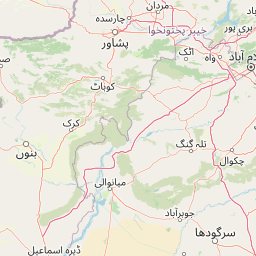
Map view of Sheikh Badin National Park

Use this park location map to pinpoint Sheikh Badin National Park in Pakistan, understand its exact geographic position, and read its mapped placement within the surrounding landscape more clearly.

Pigeon | © OpenStreetMap contributors

Location context for Sheikh Badin National Park

Dera Ismail Khan DistrictKhyber PakhtunkhwaLakki Marwat District
Park atlas

Trace the broader geographic context and compare protected landscapes near Sheikh Badin National Park.

Discover More National Parks and Protected Areas Near Sheikh Badin National Park

After exploring Sheikh Badin National Park's distinctive mountainous terrain, browse other protected areas within the surrounding regional geography of Khyber Pakhtunkhwa, Pakistan. Compare different landscapes, conservation efforts, and ecological zones found across this transitional ecosystem, enhancing your atlas-style park discovery.
Wildlife reservePunjab
About 87 km away#1 closest

South

Chashma and Taunsa Barrage Dolphin Sanctuary: Protected Riverine Geography in Punjab

Freshwater habitat boundaries and Indus River landscape context

Chashma and Taunsa Barrage Dolphin Sanctuary serves as a key protected site for the Indus river dolphin, offering a unique look at riverine conservation in Punjab. This habitat, defined by its hydrology between two major barrages, acts as an essential wetland and wildlife corridor. The area provides a specialized landscape study for those tracing the ecological features of the Indus River system through this significant protected zone.

Established
1972
Water
Major water bodies
Protected areaKhushab District
About 116 km away#2 closest

East

Uchhali Complex Protected Area: Geography, Salt Range Lakes, and Wetland Mapping

Key protected wetland landscape in the Soon Valley of Punjab

The Uchhali Complex serves as a critical wetland system characterized by the brackish and saline waters of Khabikki, Uchhali, and Jahlar lakes. Situated in the Soon Valley, this protected area offers a unique geographic perspective on the interplay between the mineralized geology of the Salt Range and the surrounding semi-arid terrain. This detail overview examines the site as a landmark habitat for migratory waterbirds and a defining feature of the Khushab District landscape.

Area
12.43 km²
Established
1996
Access
Access unknown
Scope
Terrestrial
Wildlife reservePunjab
About 147 km away#3 closest

East

Chumbi Surla Wildlife Sanctuary: Geographic Overview of Punjab Foothill Habitats

Mapping protected scrub forests and ridges in Khushab and Chakwal

Covering thousands of acres of contiguous reserve forest, Chumbi Surla Wildlife Sanctuary represents a crucial protected ecosystem within the Punjab landscape. This high-altitude scrub environment provides an essential refuge for the Punjab urial, characterized by deep valleys, stony slopes, and ridge systems that define the topography of the local Salt Range outliers.

Area
226.4 km²
Established
1978
IUCN
IV
Relief
Upland
Protected areaKhyber Pakhtunkhwa
About 150 km away#4 closest

North

Tanda Dam Protected Area: Geographic Context and Wetland Map Features in Khyber Pakhtunkhwa

Ramsar-listed reservoir and regional irrigation landscape

Tanda Dam is a critical irrigation reservoir and Ramsar-listed wetland located in the Kohat District. This protected area supports agricultural networks for surrounding villages while serving as a winter refuge for migratory waterbirds traveling from the Caspian region and Siberia. The site offers a unique perspective on managed water landscapes within the broader terrain of Khyber Pakhtunkhwa.

Area
4.05 km²
Established
1967
Relief
Lowland
Scope
Terrestrial
National parkPunjab
About 175 km away#5 closest

Northeast

Chinji National Park: National Park Atlas, Salt Range Geography, and Protected Landscape

Discover the unique eroded terrain and semi-arid ecosystems of Punjab, Pakistan.

Chinji National Park is a protected national park located in the Punjab province of Pakistan, specifically within the historic Salt Range. This park is characterized by its deeply eroded terrain, composed of sandstone and igneous rock formations, shaped by seasonal streams that lead towards the Soan River. As a key example of a semi-arid mountain ecosystem within the Baluchistan xeric woodlands ecoregion, Chinji National Park offers significant insights into the geological heritage and unique biodiversity of central Pakistan.

Area
60.95 km²
Established
1987
IUCN
II
Relief
Upland
National parkPakistan
About 189 km away#6 closest

East

Salt Range National Park: Pakistan's Protected Landscape for Geographic Atlas Exploration

Mapped boundaries and regional terrain context for a Pakistani national park.

Gain insight into Salt Range National Park, a significant national park established within Pakistan. This entry focuses on its role as a protected landscape, providing a mapped view of its geographic scope and environmental context. Understand how this park contributes to Pakistan's broader geography and offers opportunities for atlas-based discovery of its natural terrain.

Relief
Mountain
Scope
Terrestrial
National parkAttock District
About 204 km away#7 closest

Northeast

Kala Chitta National Park: Protected Dry Temperate Forest in Attock District, Pakistan

Discover unique hill landscapes and a rare ecosystem on the Pothohar Plateau.

Kala Chitta National Park represents a crucial protected area in Punjab, Pakistan, safeguarding a distinct dry temperate forest ecosystem that is uncommon in the Pothohar Plateau's heavily agricultural landscape. The park's terrain comprises rolling hills and intervening plains, contributing to its ecological richness and providing valuable mapped landscape context. Explore the geographic importance of this national park and its role in preserving a vital natural habitat.

Area
363.77 km²
Established
1983
IUCN
II
Relief
Mixed relief
Protected areaIran
About 209 km away#8 closest

South

Koh-e-Sulaiman Protected Area: Sacred Mountain Geography and Landscape Context in Iran

Discover unique terrain and cultural heritage within this protected mountain range.

Koh-e-Sulaiman is a vital protected area within Iran, distinguished by the sacred Takht-e-Sulaiman peak, a site of deep spiritual importance. This landscape features rugged mountains, steep ridges, and deep valleys, contrasting sharply with surrounding plains. The protected area's unique geological complexity and dramatic terrain make it a significant natural and cultural landmark. MoriAtlas offers detailed geographic context to understand its protected boundaries and its role in the regional atlas, focusing on landscape discovery and natural features.

Area
6,475 km²
Relief
Mountain
Climate
Arid
Access
Remote access

Common questions about visiting, size, designation, and location context for Sheikh Badin National Park

Sheikh Badin National Park FAQs for park facts, access, geography, and protected area context

Find quick answers about Sheikh Badin National Park, including protected-area facts, park geography, trail and visitor context, and how the park fits into its surrounding country and regional landscape.
MoriAtlas Explorer

Continue Your Protected Areas Search Across the Global Atlas

Deepen your exploration by continuing the structured search for national parks and protected areas worldwide. Utilize the comprehensive filtering capabilities to compare different conservation landscapes and refine your understanding of global park geography. Discover more about the distribution and characteristics of protected natural areas.

Global natural geography
