Mori Atlas logo
National parkTorronsuo National Park

Discover the vast, domed peatlands and unique boreal wetland geography of this Ramsar-recognized national park.

Torronsuo National Park: A Prime Example of Finland's Raised Bog Protected Landscape in Kanta-Häme

(Torronsuon kansallispuisto)

Torronsuo National Park offers an unparalleled opportunity to explore one of Finland's most exceptional raised bog ecosystems. Situated in the Kanta-Häme region, this protected national park showcases a unique domed peatland landscape, characterized by its immense peat depths and the distinctive ombrotrophic bog formation. As a Ramsar-designated wetland of international importance, Torronsuo provides a window into a rare boreal wilderness, inviting detailed geographic and landscape study.

raised bogwetland conservationbirdwatchingboreal ecosystemFinnish national parksRamsar site
Stylized illustration of a raised bog ecosystem with forests, ponds, and walking paths

Torronsuo National Park

National park

Park overview

Structured park overview, official facts, and landscape profile for Torronsuo National Park

Torronsuo National Park park facts, protected area profile, and essential visitor context
Review the core facts for Torronsuo National Park, including designation, size, terrain, visitor scale, habitats, and operating context in one park-focused overview.

About Torronsuo National Park

Torronsuo National Park protects a landscape of outstanding ecological significance in southern Finland. The raised bog represents a classic example of ombrotrophic bog development, where precipitation alone supplies the water and nutrients that sustain the ecosystem. Over thousands of years, sphagnum moss and other peat-forming plants have accumulated to create the thick turf layer that defines this landscape. The bog's central section rises noticeably above its edges, creating the characteristic dome shape that gives raised bogs their name. This geological formation, combined with the park's location at a biogeographical crossroads, creates conditions that support unusual species assemblages. The park lies in Tammela municipality within the Kanta-Häme region, an area known for its extensive forest and wetland systems. Before its formal designation as a national park in 1990, the area already enjoyed protected status as a near-natural swamp area. The park now serves as both a conservation refuge and a recreational resource, offering visitors a chance to experience the haunting beauty of芬兰's bog landscapes. The infrastructure includes well-maintained boardwalk trails that allow exploration without disturbing the sensitive bog surface, and observation towers that provide panoramic views of this unique environment.

Quick facts and research context for Torronsuo National Park

Torronsuo National Park occupies approximately 25.5 square kilometers of protected bog landscape in Kanta-Häme, southern Finland. The park is managed by Metsähallitus and receives around 58,600 annual visitors. The raised bog formation features one of the deepest peat layers recorded in Finland, with measurements reaching 12 meters in some areas. The ecosystem supports roughly 100 nesting bird species, including species more typical of northern Finland that are rarely found elsewhere in the southern parts of the country. The park also supports significant butterfly populations and diverse plant communities.

Park context

Deeper park guide and search-rich context for Torronsuo National Park

Torronsuo National Park history, landscape, wildlife, and travel context
Explore Torronsuo National Park through its history, landscape character, ecosystems, wildlife, conservation priorities, cultural context, and seasonal travel timing in a structured park guide built for atlas discovery and search intent.

Why Torronsuo National Park stands out

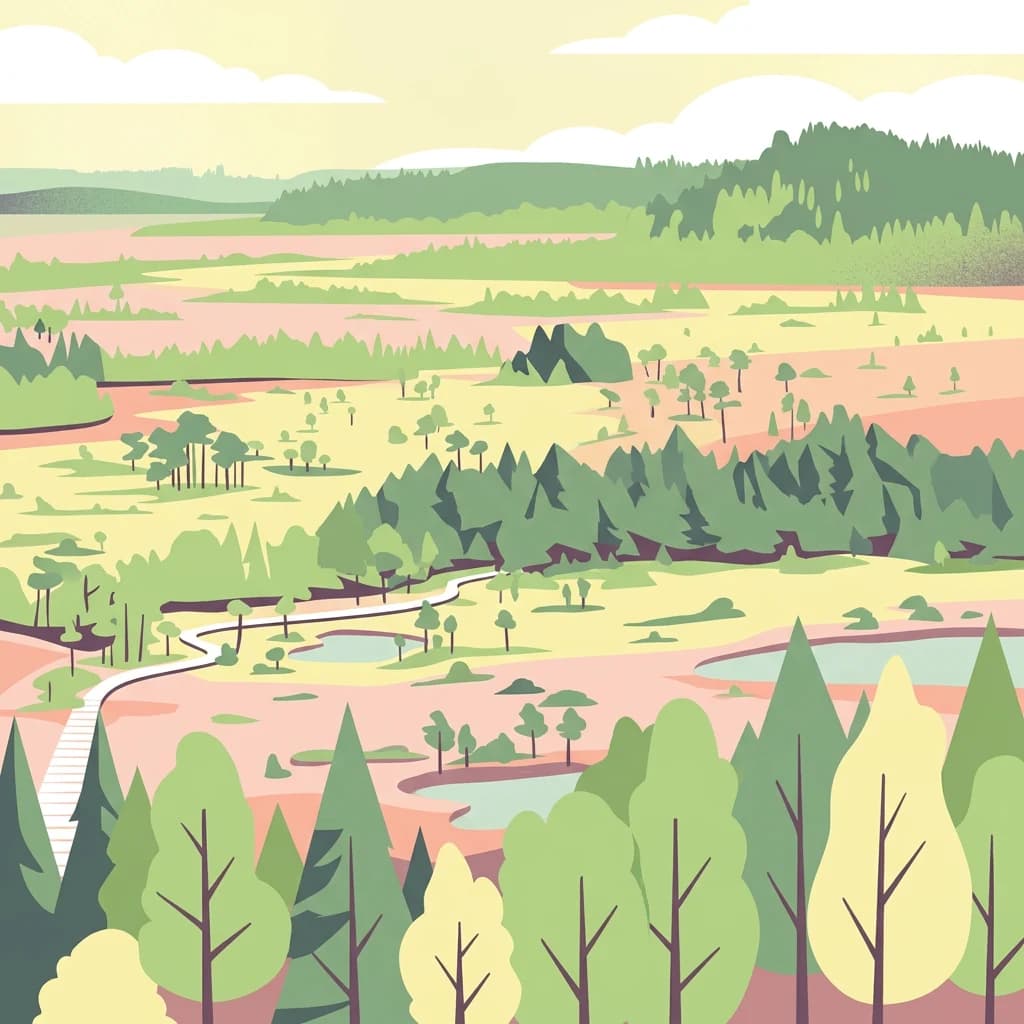
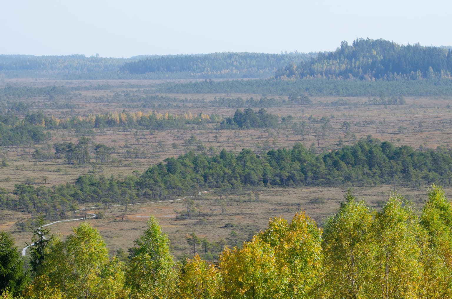
Torronsuo is best known for its exceptional raised bog ecosystem, one of the most pristine and visually striking in Finland. The ombrotrophic bog, where all water and nutrients come from precipitation, creates a distinctive dome-shaped landscape with the central peat mass rising notably above its margins. The park is renowned for its northern bird species that nest here at the southern edge of their range, and for the remarkable butterfly diversity that thrives in this specialized habitat. The two observation towers, particularly the 17-meter Kiljamo scenic tower, provide sweeping views across the endless bog expanse, making the park a favorite destination for nature photography and birdwatching.

Wide landscape showing Torronsuo National Park's bog with scattered trees, open marshy plains, and forested hills in the background
Panoramic view of Torronsuo National Park's bog landscape with autumn-colored trees and distant forested hills

Torronsuo National Park history and protected-area timeline

Torronsuo National Park was established in 1990, though the area had already received protected status before this designation as a near-natural state swamp area. The formal national park status elevated the protection of this already-valuable ecosystem and brought it under the management framework of Metsähallitus, Finland's parks and wildlife service. In 1997, a significant event shaped part of the park's eastern edge when the Tammela large forest fire burned a portion of the protected area. While fire crews successfully prevented the blaze from spreading further into the core bog area, the burned forest was left standing and allowed to regenerate naturally, demonstrating the park's commitment to natural ecological processes. A portion of the burned area was subsequently incorporated into the national park boundaries. The same year saw the construction of the Idänpäänkallio observation tower in the southern part of the park, built largely through volunteer efforts by the local Torro village committee. This community involvement reflects the strong local connection to the park and its landscape.

Torronsuo National Park landscape and geographic character

The landscape of Torronsuo is defined by its classic raised bog formation, one of the most characteristic and visually distinctive wetland types in northern Europe. The bog's surface displays the domed profile typical of ombrotrophic bogs, where the central peat accumulation rises several meters above the surrounding marginal areas. This topography creates a subtle but unmistakable elevation change as visitors move from the bog margins toward its center. The peat layer here ranks among the thickest ever measured in Finnish bogs, locally reaching 12 meters in depth. The bog surface supports a cover of sphagnum mosses, cotton grass, and dwarf shrubs, creating a mostly open landscape with scattered pine trees at the margins. Between the wet bog中心和 drier hummocks, the terrain creates a subtle mosaic of microhabitats. The park includes small islands of drier ground, such as the Kiljamo area that serves as the main visitor access point, where the terrain transitions to forest. The landscape gains additional interest from the old quartz quarry at Härksaare, a reminder of human interaction with this seemingly remote environment.

Wooden boardwalk extending through a boggy landscape with patches of water, surrounded by sparse trees and vegetation
Boardwalk restoration work in Torronsuo National Park near Kiljamo

Torronsuo National Park ecosystems, habitats, and plant life

The nature of Torronsuo centers on its raised bog ecosystem, a habitat of high conservation value across Europe. The ombrotrophic bog receives all its water and nutrients exclusively from precipitation, creating acidic, nutrient-poor conditions that support a specialized plant community adapted to these challenging circumstances. The sphagnum moss layer forms the living carpet that builds the peat over time, while cotton grass, Andromeda, and various cranberry and blueberry species dominate the vascular plant cover. The park's ecological significance is enhanced by its position in southern Finland, where many northern species reach the southern limit of their range. This biogeographical positioning creates an unusual mix of species, with some bird and insect species present here that are rarely encountered in the more populated southern Finnish landscapes. The plant community also includes species characteristic of both southern and northern Finland, reflecting the transitional nature of the location.

Torronsuo National Park wildlife and species highlights

Torronsuo supports remarkably diverse wildlife for a bog ecosystem, with approximately 100 bird species nesting within the park boundaries. The bird community includes several species that are more typical of northern Finnish forests and wetlands, making their presence here at the southern edge of their range particularly notable. These northern species find suitable habitat in the bog's open landscapes and the surrounding mire forests. The park is also significant for butterfly species, with the specialized bog environment supporting populations that depend on this increasingly rare habitat type. The diverse insect community contributes to the ecological web that sustains the park's bird life. While larger mammals use the area, the primary wildlife interest centers on the bird and invertebrate populations that define the park's ecological character. The observation towers provide excellent opportunities for birdwatching, particularly during the breeding season when activity peaks across the bog.

Torronsuo National Park conservation status and protection priorities

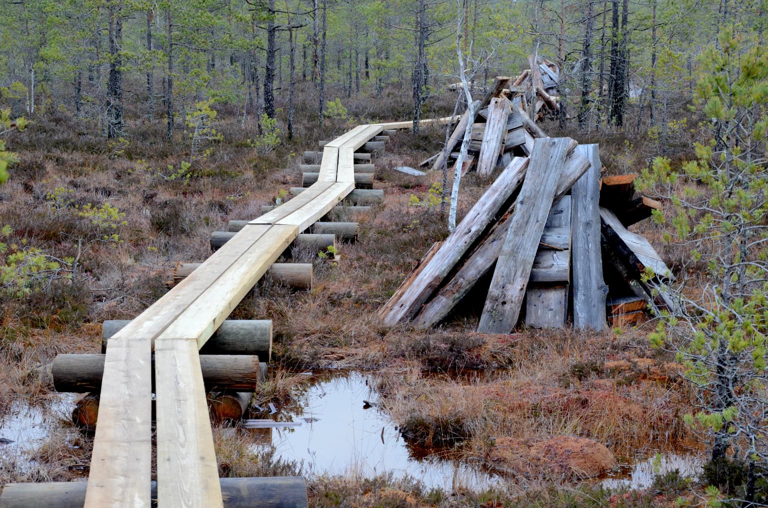
Torronsuo holds Ramsar Convention status as a Wetland of International Importance, reflecting its significance within the global network of protected wetlands. The park protects one of Finland's finest raised bog examples, a habitat type that has declined dramatically across Europe due to drainage, peat extraction, and forestry. The ombrotrophic bog ecosystem represents a increasingly rare landscape, making conservation of areas like Torronsuo essential for maintaining biodiversity. The park's protected status ensures the continuation of natural processes that sustain the bog, including the ongoing accumulation of peat that maintains the ecosystem's ecological character. The presence of northern species at their southern range limit adds conservation value, as these populations depend on the park for breeding habitat that cannot be easily replicated elsewhere. Metsähallitus manages the park with a focus on maintaining natural ecological processes while providing sustainable recreational access through the boardwalk trail system.

Torronsuo National Park cultural meaning and human context

Torronsuo lies within the municipality of Tammela in the Kanta-Häme region of southern Finland, an area with strong connections to the traditional Finnish landscape of forests, lakes, and wetlands. The local village of Torro provides the historical human context for the park's eastern section, and the community has maintained an active relationship with the protected area. The Idänpäänkallio observation tower in the park's southern section was built in 1997 largely through volunteer efforts organized by the Torro village committee, demonstrating local stewardship of the park. The old quartz quarry at Härksaare reflects historical mineral extraction that occurred in the area before national park designation. The park's Finnish name, Torronsuon kansallispuisto, directly translates as Torronsuo National Park, using the Finnish nomenclature common for Finland's protected areas. The region's cultural landscape reflects generations of human interaction with the forest and wetland environments that dominate southern Finland.

Top sights and standout views in Torronsuo National Park

Torronsuo National Park offers several standout features that make it a distinctive destination within Finland's protected area network. The raised bog landscape, with its thick peat layers reaching 12 meters, represents one of the most impressive bog formations in the country. The two observation towers provide exceptional panoramic views across the bog expanse, with the 17-meter Kiljamo tower being the most prominent. The park's birdlife, with approximately 100 nesting species including northern species at their southern range limit, makes it a premier birdwatching destination. The extensive boardwalk trail network allows visitors to explore the bog safely while protecting the sensitive ecosystem, with routes ranging from 1.5 kilometers to 10 kilometers in length. The presence of significant butterfly populations adds entomological interest. The Ramsar designation underscores the park's international conservation significance.

Best time to visit Torronsuo National Park

The best time to visit Torronsuo National Park depends on the experience sought, but the park offers meaningful experiences across multiple seasons. Spring and early summer bring the peak of bird activity as nesting species establish territories across the bog, making late May and June excellent for birdwatching. The cotton grass blooming in early summer creates distinctive white patches across the bog landscape. Summer months offer the warmest conditions for hiking the boardwalk trails, though mosquitoes can be prevalent. Autumn brings the bog's colors as the dwarf shrubs turn red and orange, creating striking visual contrast against the green sphagnum. Winter transforms the landscape into a silent white wilderness, and the park maintains ski trails for winter recreation. The observation towers provide good views in most seasons, though winter's snow and ice require appropriate equipment. The 58,600 annual visitors are distributed across the year, with summer months typically seeing the highest visitation.

Park location guide

Geography guide, regional context, and park location map for Torronsuo National Park

Torronsuo National Park park geography, regions, and map view in Finland
Understand where Torronsuo National Park sits in Finland through a broader geographic reading of the surrounding landscape, nearby location context, and its mapped position within the national park landscape.

How Torronsuo National Park fits into Finland

Finland, officially the Republic of Finland, is a Nordic country in Northern Europe with a population of 5.6 million. It borders Sweden, Norway, and Russia, with the Gulf of Bothnia to the west and the Gulf of Finland to the south. The country gained independence from Russia in 1917 and is a unitary parliamentary republic. Its landscape is characterized by extensive boreal forests and over 180,000 lakes.

Wider geography shaping Torronsuo National Park in Finland

Finland is located in Northern Europe, occupying a peninsula bordered by the Gulf of Bothnia to the west and the Gulf of Finland to the south. It shares land borders with Sweden to the northwest, Norway to the north, and Russia to the east. The terrain is predominantly flat with extensive forest coverage and numerous lakes.

Map view of Torronsuo National Park

Use this park location map to pinpoint Torronsuo National Park in Finland, understand its exact geographic position, and read its mapped placement within the surrounding landscape more clearly.

Pigeon | © OpenStreetMap contributors

Location context for Torronsuo National Park

Kanta-Häme

A Visual Atlas of the Park's Unique Peatland Scenery, Boreal Habitats, and Protected Wetland Character

Torronsuo National Park Photos: Explore Finland's Distinctive Raised Bog Landscapes
Browse comprehensive imagery of Torronsuo National Park to visually explore its distinctive raised bog landscapes and protected wetland environment, a key Ramsar site in southern Finland. These photographs provide essential visual context for understanding the park's ombrotrophic peatlands, boreal habitats, and unique ecological formations within the Kanta-Häme region.

Wide landscape showing Torronsuo National Park's bog with scattered trees, open marshy plains, and forested hills in the background

A wide view of Torronsuo National Park's snow-covered bog with scattered trees and forest in the background

Wooden boardwalk extending through a boggy landscape with patches of water, surrounded by sparse trees and vegetation

Park atlas

Compare nearby protected areas, tracing their geographic context and regional conservation landscapes.

Discover Other National Parks and Protected Areas Near Torronsuo National Park in Southern Finland
Expand your exploration from Torronsuo National Park by browsing other national parks and protected areas across southern Finland's varied geography. Compare these diverse conservation landscapes, tracing their geographic distribution and distinct ecological features to enhance your regional park atlas.
Watercolor painting showing a lake surrounded by vegetation with rolling hills in the background
National parkKanta-Häme

Liesjärvi National Park: Protected Landscape in Kanta-Häme's Finnish Lakeland

Explore its mapped geography and protected area context.

Liesjärvi National Park is a designated national park situated in the Kanta-Häme region, a landscape rich with the characteristic features of southern Finland's Finnish Lakeland. This page serves as a focused entry point for understanding the park's protected status, its unique geographic setting, and its contribution to the regional atlas of natural landscapes. By examining Liesjärvi National Park, users gain insight into the mapped terrain and conservation efforts that define this part of Finland, fostering a deeper appreciation for protected areas.

Area
22 km²
Established
1956
IUCN
II
Visitors
57.3K annual
Watercolor painting showing green hills, trees, and a stream in a landscape
National parkSouthwest Finland

Kurjenrahka National Park: Southwest Finland's Protected Landscape Atlas Entry

Discover geographic context and park boundaries.

Delve into Kurjenrahka National Park, a designated national park situated in Southwest Finland. This page provides an atlas-focused view of the park, detailing its protected landscape identity, mapped terrain, and its specific geographic location within the broader Finnish region. Understand the park's ecological context and its significance as a key protected area for regional geographic exploration.

Area
29 km²
Established
1998
IUCN
II
Visitors
66.8K annual
National parkSouthwest Finland

Teijo National Park: Mapped Boundaries of a Protected National Park in Southwest Finland

Explore the geographic context and protected landscape of Teijo National Park.

Teijo National Park is a designated national park within Southwest Finland, offering a distinct protected landscape for atlas exploration. This entry focuses on its geographic identity, mapped park boundaries, and its place within the broader regional geography. Discover the structured details of Teijo National Park as a key protected area, providing valuable context for understanding natural landscapes and conservation efforts in Finland.

Area
34 km²
Established
2015
IUCN
II
Visitors
92.1K annual
National parkUusimaa

Nuuksio National Park: Uusimaa Region Protected Landscape Atlas Entry

Mapped boundaries and geographic context for a Finnish National Park.

Access detailed geographic information and mapped boundaries for Nuuksio National Park, a protected national park within the Uusimaa region. This MoriAtlas entry provides context for understanding its landscape within Finland, focusing on atlas-style exploration and the identification of protected natural areas.

Area
53 km²
Established
1994
IUCN
II
Visitors
312.6K annual
National parkPirkanmaa

Puurijärvi-Isosuo National Park: Protected Landscape Discovery in Pirkanmaa Region

Explore mapped protected areas and regional geography.

Puurijärvi-Isosuo National Park is a significant protected area in Finland's Pirkanmaa region. This entry provides detailed geographic context and maps the park's boundaries, offering a focused perspective for atlas-driven discovery of Finnish natural landscapes. Understand its place within the regional geography and the wider network of protected lands.

Area
27 km²
Established
1993
IUCN
II
Visitors
19.8K annual
Watercolor illustration showing green trees, a river, and rolling hills under a soft sky
National parkUusimaa

Sipoonkorpi National Park: Protected Landscape and Geography in Uusimaa

Explore Finland's key national park and its natural terrain.

Discover Sipoonkorpi National Park, a vital protected landscape in Finland's Uusimaa region. This page offers detailed insight into its mapped boundaries, diverse boreal forests, extensive swamp areas, and the unique terrain that defines this significant natural area. Understand its role as one of the last undeveloped green spaces near the Helsinki metropolitan area and explore its geographic context within southern Finland.

Area
18.57 km²
Established
2011
IUCN
II
Visitors
165.5K annual
National parkUusimaa

Ekenäs Archipelago National Park: Mapped Baltic Sea Archipelago Landscape

Protected marine area with island geography in Uusimaa, Finland.

Delve into the unique protected landscape of Ekenäs Archipelago National Park, a premier example of a Baltic Sea marine protected area. Located in the Uusimaa region, this national park encompasses a vast expanse of coastal waters dotted with hundreds of rocky islets and skerries. MoriAtlas provides detailed geographic context, allowing for exploration of its mapped boundaries, island formations, and critical role as a sanctuary for breeding aquatic birds. Understand its place within Finland's protected areas atlas and appreciate its distinctive marine archipelago character.

Area
52 km²
Established
1989
IUCN
II
Visitors
53.6K annual
National parkPäijät-Häme

Päijänne National Park: Mapped Island Archipelago in Finland's Päijät-Häme Region

Explore unique glacial geology and boreal island wilderness.

Päijänne National Park presents a compelling protected landscape for atlas discovery, focusing on its distinct archipelago character within Lake Päijänne, Southern Finland. This national park features numerous islands showcasing ancient geological formations, from rocky outcrops to sandy beach ridges and moraine formations. Its mapped terrain offers insights into glacial processes and the development of boreal island ecosystems. Navigate its unique island settings to understand the geographic context of this protected area in the Päijät-Häme region.

Area
14 km²
Established
1993
IUCN
II
Visitors
67K annual

Common questions about visiting, size, designation, and location context for Torronsuo National Park

Torronsuo National Park FAQs for park facts, access, geography, and protected area context
Find quick answers about Torronsuo National Park, including protected-area facts, park geography, trail and visitor context, and how the park fits into its surrounding country and regional landscape.
MoriAtlas Explorer

Continue Your Protected Areas Search Across the Global Atlas

Deepen your exploration by continuing the structured search for national parks and protected areas worldwide. Utilize the comprehensive filtering capabilities to compare different conservation landscapes and refine your understanding of global park geography. Discover more about the distribution and characteristics of protected natural areas.

Global natural geography