Mori Atlas logo
National parkTusheti National Park

Discover the mapped boundaries and distinct geographic character of this protected area in Georgia.

Tusheti National Park National Park: Caucasus Mountain Landscape & Protected Area Geography

Tusheti National Park represents a significant protected landscape within Georgia's Caucasus mountain system. Situated in the remote northeastern region, this national park showcases dramatic alpine terrain, including steep river valleys, towering peaks that form the continental divide, and diverse ecological zones shaped by millennia of glacial processes. MoriAtlas provides a detailed geographic context for Tusheti National Park, highlighting its unique mapped boundaries and its role in preserving a crucial area of the Caucasus.

Caucasus mountainsAlpine landscapesPine forestsEndangered speciesWildlife conservationTraditional villages

Tusheti National Park

National park

Park overview

Structured park overview, official facts, and landscape profile for Tusheti National Park

Tusheti National Park park facts, protected area profile, and essential visitor context
Review the core facts for Tusheti National Park, including designation, size, terrain, visitor scale, habitats, and operating context in one park-focused overview.

About Tusheti National Park

Tusheti National Park protects one of Georgia most remote and ecologically significant mountain regions, where dramatic alpine scenery combines with remarkable biodiversity and living cultural traditions. The park occupies the Tusheti basin, a highland area cradled between the towering peaks of the Caucasus main ridge to the north and the lower Sperozi ridge to the west. Two principal river valleys—the Pirikiti and Gometsri Alazani—traverse the protected area, carrying glacial meltwater through forested gorges before descending toward the broader Kakheti lowlands. The park was established in 2003 as part of Georgias Protected Areas Development Project, which received support from the Global Environment Facility and the World Bank. This institutional foundation reflects the parks dual purpose: conserving globally significant biodiversity while supporting the traditional livelihoods of the approximately fifty nomadic communities who maintain seasonal grazing rights within the protected area. The visitor center is located in lower Omalo, from where a challenging 85-kilometer mountain road extends along the main watershed ridge. This road, traversing hilly terrain that can be difficult to navigate, provides access to some of the most spectacular alpine landscapes in the Caucasus.

Quick facts and research context for Tusheti National Park

Tusheti National Park is located in the Tusheti mountainous region of northeastern Georgia, approximately 205 kilometers from Tbilisi. The park covers an area of roughly 71,000 hectares and was established in 2003 under IUCN Category II. It forms part of a larger protected area complex that includes Tusheti Protected Landscape and Tusheti Strict Nature Reserve, together covering over 113,000 hectares. The park lies within the Caucasus mixed forests ecoregion and spans elevations from 900 to over 4,400 meters, with the highest peaks including Tebulosmta and Diklosmta. The area is notable for its population of endangered wild goats and represents one of Georgia's most important conservation areas.

Park context

Deeper park guide and search-rich context for Tusheti National Park

Tusheti National Park history, landscape, wildlife, and travel context
Explore Tusheti National Park through its history, landscape character, ecosystems, wildlife, conservation priorities, cultural context, and seasonal travel timing in a structured park guide built for atlas discovery and search intent.

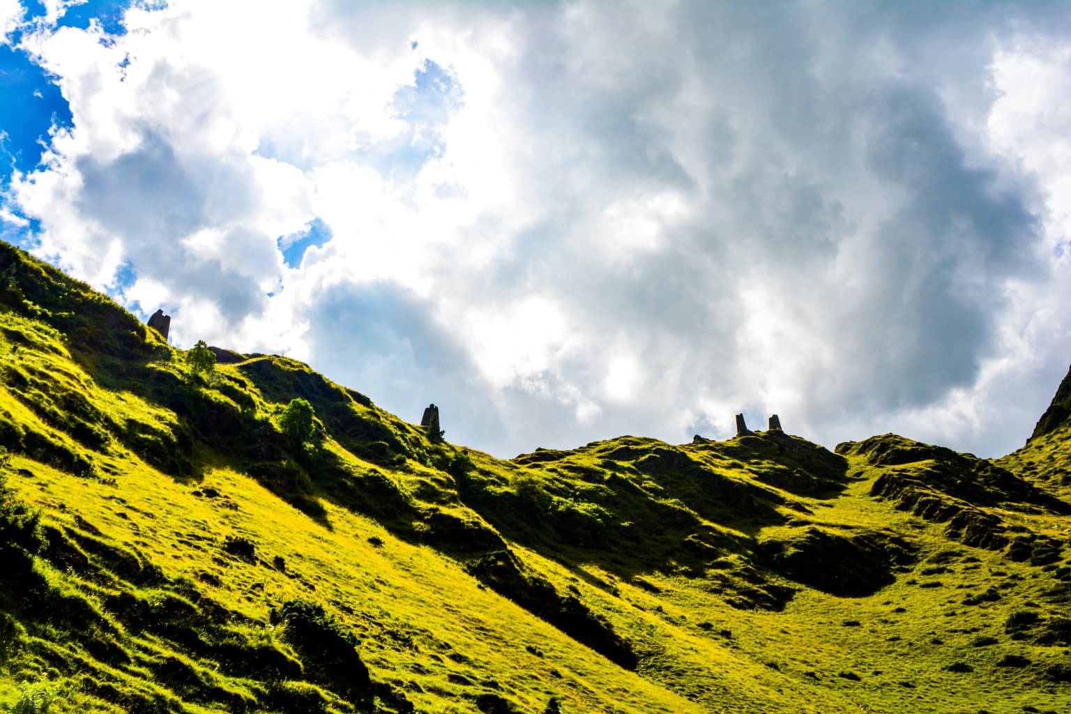
Why Tusheti National Park stands out

Tusheti is renowned for its exceptionally well-preserved alpine pine forests and its population of wild goats, for which the park represents the only intact remaining habitat. The park protects critical terrain for the endangered Anatolian leopard and supports significant populations of large predators including wolves and lynx. Its dramatic mountain scenery, with ancient defense towers rising above flower-rich subalpine meadows, creates one of the Caucasus most iconic cultural landscapes. The park was recognized as one of the twelve best places people have never heard of by BudgetTravel in 2011, cited for both its biological richness and the traditional mountain villages, old towers, cuisine, and folk culture that distinguish this remote corner of Georgia.

Tusheti National Park history and protected-area timeline

Tusheti National Park was established in April 2003 when the Parliament of Georgia approved the creation of eight new protected areas across the country. This legislative action represented a significant expansion of Georgias conservation estate and was supported through the Georgia Protected Areas Development Project, a collaboration between the Global Environment Facility, the World Bank, and the Georgian government. The parks establishment recognized both the exceptional ecological value of the Tusheti region and the need to integrate conservation with the traditional land-use practices of local communities. Prior to formal protection, the Tusheti region had long been recognized for its natural and cultural values, though the absence of formal protected area status left its wildlife and landscapes vulnerable to pressures from development and unsustainable use. The creation of the national park was accompanied by the designation of adjacent areas as Tusheti Protected Landscape and Tusheti Strict Nature Reserve, together forming a comprehensive conservation framework that addresses different levels of protection and user access across the broader Tusheti territory.

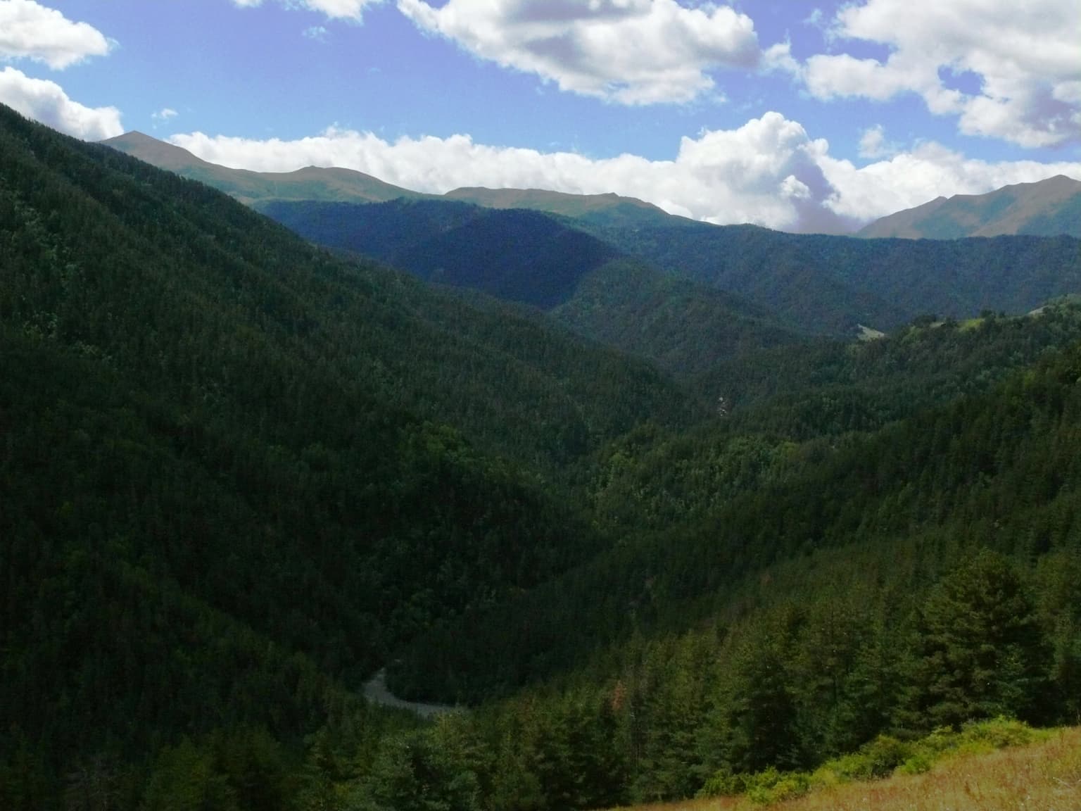
Tusheti National Park landscape and geographic character

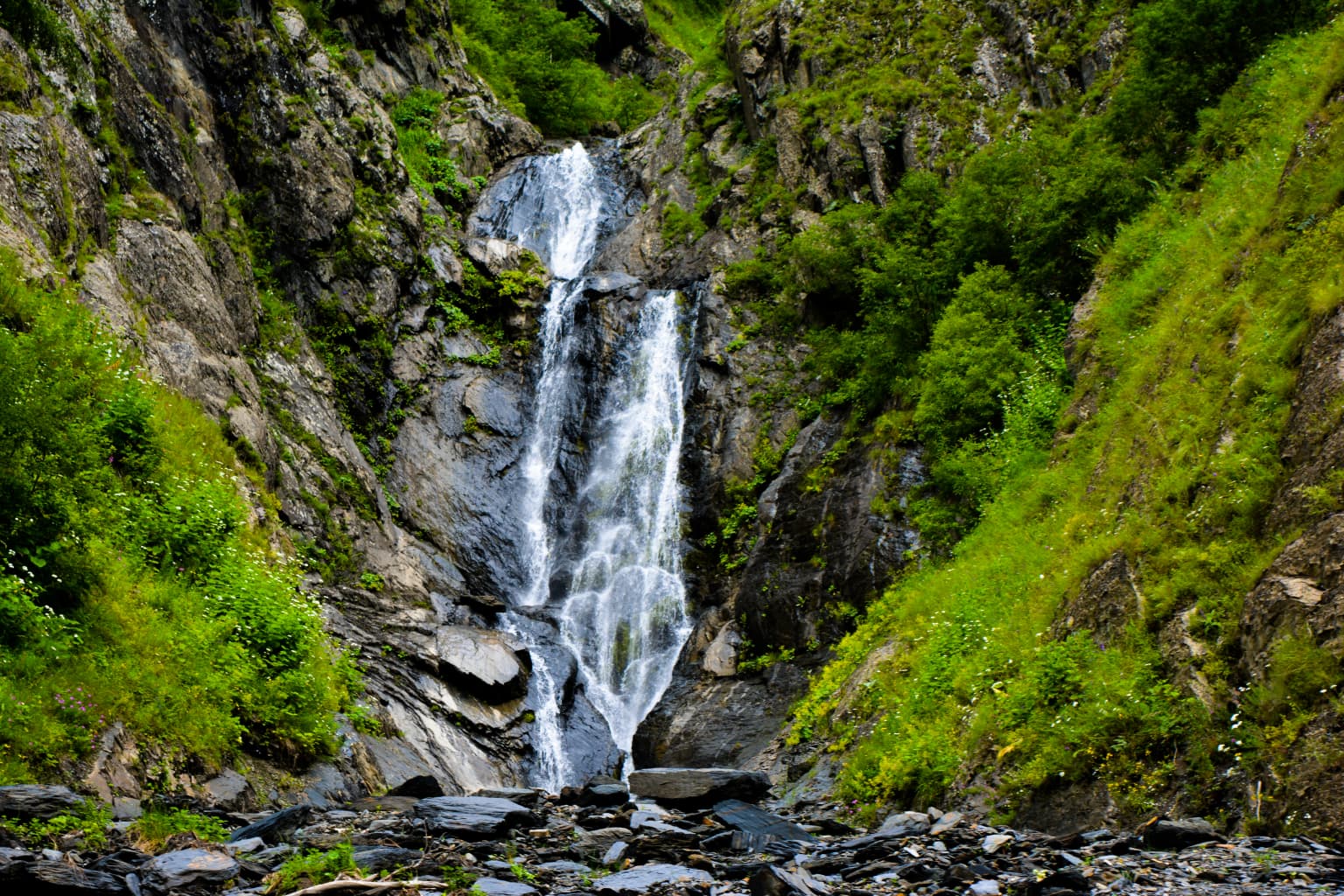
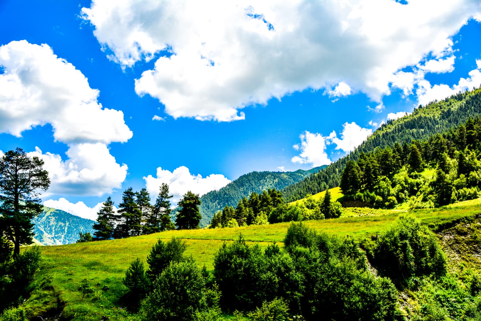
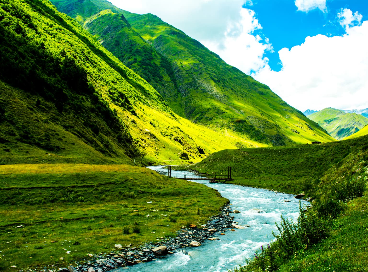
The landscape of Tusheti National Park is defined by the meeting of two parallel mountain valleys carved by the Pirikiti and Gometsri Alazani rivers, which flow between the main Caucasus ridge and the outlying Sperozi ridge. The terrain is characterized by steep-sided gorges, broad glacial valleys, and towering peaks that exceed 4,000 meters, with Tebulosmta reaching 4,492 meters as the highest summit within the protected area. The geology is dominated by Jurassic schists, with travertine deposits occurring in the Pirikiti valley near Dartlo. Glacial processes have shaped the upper reaches of both valleys, leaving behind classic glacialcirques above 2,700 meters and moraine deposits in the valley floors. The parks eastern section experiences elevation differences exceeding 2,500 meters between the lowest points around 1,600 meters and the highest peaks approaching 4,300 meters. This dramatic vertical relief, combined with varied aspect and exposure, creates a complex mosaic of microclimates and ecological zones. The Omalo plateau represents one of the driest and warmest locations in the region, while the higher peaks support permanent snow and glaciers.

Tusheti National Park ecosystems, habitats, and plant life

The vegetation of Tusheti National Park reflects the transition from humid temperate forest at lower elevations through subalpine birch and pine forest to alpine meadows and permanent snow fields. Well-preserved pine groves of Pinus sylvestris dominate the forested slopes, with birch woodland of Betula pubescens and the rarer Betula raddeana forming important components of the forest composition. At higher elevations, subalpine meadows support diverse herbaceous vegetation, while the rocky ridgelines and peaks support specialized alpine communities. The forest boundaries and modern distribution of pine and meadow communities have been significantly influenced by centuries of transhumant grazing, which has shaped the characteristic mosaic of open forest and grassland that defines much of the park. The parks position within the Caucasus biodiversity hotspot and its inclusion in the Caucasus mixed forests ecoregion reflects the exceptional floristic diversity found within its boundaries, with numerous endemic and relict species persisting in the isolated mountain habitats.

Tusheti National Park wildlife and species highlights

Tusheti supports a remarkable assemblage of large mammals and raptors that reflect the parks position at the interface between European and Asian faunal realms. The endangered Anatolian leopard remains a flagship predator within the park, though sightings are extremely rare. The wild goat, or bezoar goat, finds its only intact habitat within the protected area, making the park globally significant for conservation of this species. Other notable mammals include brown bears, wolves, lynx, and chamois, which inhabit the rocky terrain and forested slopes. The avifauna is particularly rich, with species such as the golden eagle, lammergeyer, and various other raptors nesting on the cliff faces and hunting the alpine meadows. The eastern imperial eagle, greater spotted eagle, lesser kestrel, steppe eagle, and black kite are among the predatory birds that occur in the park, while the Caucasian grouse and Caucasian snowcock inhabit the higher terrain. The park also protects several species listed in the Georgia Red List, including seven mammals, ten birds, and one fish species—the trout.

Tusheti National Park conservation status and protection priorities

Tusheti National Park represents one of the most important conservation areas in the Caucasus region, protecting both critical habitat for endangered species and a functioning mountain ecosystem shaped by traditional land use. The parks significance for the wild goat, which exists in only this single intact population within Georgia, has prompted targeted conservation efforts including monitoring programs and wildlife viewing trail development. The Centre for Biodiversity Conservation and Research, an IUCN member, has worked with local partners to establish viewing potential programs that enable visitors to observe this species while ensuring protection from poaching. The park is part of the larger Tusheti Protected Areas complex, which includes the Tusheti Strict Nature Reserve providing the highest level of protection to core areas of critical habitat, and the Tusheti Protected Landscape surrounding the traditional villages and grazing areas. This zoned approach attempts to balance biodiversity protection with the legitimate needs of the fifty or more nomadic communities whose traditional seasonal grazing practices remain integral to the cultural landscape.

Tusheti National Park cultural meaning and human context

The Tusheti region is home to a distinctive mountain culture characterized by traditional villages, ancient stone defense towers, and a pastoral economy based on seasonal grazing. These villages, including Omalo, Diklo, Shenako, and others, are nestled in the valleys and on the slopes above the river floodplains, their tower-houses visible against the dramatic mountain backdrop. The traditional practice of transhumance, whereby pastoralists move their flocks to high-altitude summer pastures, has shaped both the cultural landscape and the vegetation patterns within what is now the protected area. The visitor center and administrative functions of the park are centered in lower Omalo, the main village hub for this dispersed mountain community. The parks establishment has sought to balance conservation objectives with recognition of these traditional rights and practices, with the protected area specifically designed to support the interests of the nomadic communities while protecting the natural values on which the broader ecosystem depends.

Top sights and standout views in Tusheti National Park

Tusheti National Park offers a rare combination of pristine alpine nature, living cultural traditions, and dramatic mountain scenery in one of the Caucasus most remote protected areas. The well-preserved pine forests, flower-rich subalpine meadows, and towering peaks provide exceptional hiking and wildlife viewing opportunities, while the traditional villages with their distinctive tower-houses offer a glimpse into a mountain way of life that has persisted for centuries. The parks population of wild goats, which can be observed with the help of trained local guides, represents a conservation success story where protected area management has enabled both species protection and controlled tourism access. The challenging access road, while difficult to navigate, rewards those who make the journey with landscapes that remain among the least changed in the Caucasus.

Best time to visit Tusheti National Park

The summer months from June through September offer the most favorable conditions for visiting Tusheti, when the high-altitude routes are accessible and the alpine meadows are at their most colorful. The park experiences a continental climate with cold, relatively dry winters and short, cool summers, with precipitation patterns varying significantly by elevation and aspect. Summer temperatures at the higher elevations remain cool, while the lower valleys can be quite warm. The winter months bring heavy snowfall that closes access to the higher terrain, making the traditional seasonal movement of pastoralists between valley winter quarters and summer pastures a key factor in understanding the landscape. The Omalo plateau experiences relatively low annual precipitation of around 748 millimeters, with most falling during the warmer months from April through September. Visitors planning trips should be aware that the access road requires careful planning and that the mountain environment demands appropriate preparation for variable weather conditions.

Park location guide

Geography guide, regional context, and park location map for Tusheti National Park

Tusheti National Park park geography, regions, and map view in Georgia
Understand where Tusheti National Park sits in Georgia through a broader geographic reading of the surrounding landscape, nearby location context, and its mapped position within the national park landscape.

How Tusheti National Park fits into Georgia

Georgia is a transcontinental country spanning Eastern Europe and West Asia, situated in the Caucasus region along the Black Sea. It declared independence from the Soviet Union in 1991 and today functions as a unitary parliamentary republic with Tbilisi as its capital. The nation is notable for its distinctive Georgian language, Orthodox Christian traditions dating to the 4th century, and archaeological evidence of the world's earliest winemaking sites.

Wider geography shaping Tusheti National Park in Georgia

Georgia occupies a strategic position at the crossroads of Eastern Europe and West Asia, bordered by Russia to the north and northeast, the Black Sea to the west, Turkey and Armenia to the south, and Azerbaijan to the southeast. The terrain is predominantly mountainous in the north with the Greater Caucasus range, transitioning to plains and valleys in the east. The country spans approximately 69,700 square kilometres.

Map view of Tusheti National Park

Use this park location map to pinpoint Tusheti National Park in Georgia, understand its exact geographic position, and read its mapped placement within the surrounding landscape more clearly.

Pigeon | © OpenStreetMap contributors

Location context for Tusheti National Park

Kakheti
Park atlas

Trace the broader geographic spread of protected landscapes within Georgia's rugged Caucasus region.

Explore Other National Parks and Protected Areas Near Tusheti National Park
After exploring Tusheti National Park, discover other national parks and protected areas across Georgia and the wider Caucasus mountain range. Compare diverse park geographies, from high alpine peaks and glacial valleys to unique forest ecosystems, to enrich your understanding of regional conservation landscapes.
Watercolor painting showing a landscape with green hills, trees, and distant mountains
National parkMtskheta-Mtianeti

Pshav-Khevsureti National Park: Protected Mountain Landscape and Regional Geography in Mtskheta-Mtianeti

Explore rugged terrain and alpine ecosystems in Georgia's Caucasus.

Pshav-Khevsureti National Park is a key protected area in Georgia's Mtskheta-Mtianeti region, recognized for its dramatic mountain terrain, deep river valleys, and alpine zones. Established as a national park, it safeguards the watersheds of major rivers, supporting significant wildlife and offering a compelling geographic context for atlas exploration. This protected landscape provides insight into the unique natural and cultural heritage of the Khevsureti region, making it a focal point for understanding Georgia's protected area network and mountainous geography.

Area
1,400.44 km²
Established
2014
IUCN
II
Relief
Mountain
Watercolor illustration of a landscape with mountains, a river, trees, and grassy fields
National parkMtskheta Municipality

Tbilisi National Park: Oldest Protected Landscape in Mtskheta Municipality

Explore Georgia's oldest national park and its mapped forest terrain.

Tbilisi National Park represents Georgia's oldest protected area, nestled in the Saguramo Range within Mtskheta Municipality. This page provides an atlas-focused view of its geographic features, including mountainous terrain and deciduous forest ecosystems. Users can explore the park's mapped boundaries and understand its significance as a crucial natural landscape close to Tbilisi, contributing to the region's protected areas network.

Area
380.02 km²
Established
1973
IUCN
II
Relief
Highland
National parkMtskheta-Mtianeti

Kazbegi National Park: Georgia's Alpine Protected Landscape & Regional Geography

Explore its dramatic terrain and protected area boundaries.

Kazbegi National Park offers a unique glimpse into the dramatic alpine geography of the Greater Caucasus. As a protected national park in the Mtskheta-Mtianeti region, it showcases rugged terrain, high-altitude ecosystems, and significant natural features. MoriAtlas provides a structured way to understand the park's physical characteristics, its mapped presence, and its place within the broader regional atlas, highlighting the distinct landscape of this Georgian protected area.

Area
1,446.17 km²
Established
1976
IUCN
II
Relief
Mountain
Watercolor illustration of a mountainous landscape with green forests, rolling hills, and distant mountains under a light sky
National parkGeorgia

Algeti National Park: Explore Georgia's Protected Coniferous Forest Landscape

Mountain terrain, protected forests, and regional geography.

Algeti National Park, located in Georgia's Kvemo Kartli region, serves as a critical protected area preserving the easternmost populations of Caucasian Spruce and Nordmann Fir. This national park features a dramatic mountainous landscape within the Trialeti Range, characterized by deeply incised valleys, flowing rivers, and extensive old-growth forest ecosystems. Users can explore the park's geographic context, mapped boundaries, and the ecological significance of its unique coniferous and mixed forests, contributing to a broader understanding of protected lands in the Caucasus.

Area
68.22 km²
Established
2007
IUCN
II
Visitors
8K annual
National parkNorth Ossetia-Alania

Alaniya National Park: Protected Glacial Mountain Landscape in North Ossetia-Alania, Russia

Explore dramatic terrain and ancient heritage.

Alaniya National Park, situated in the rugged Central Caucasus Mountains of North Ossetia-Alania, Russia, is a premier example of a protected landscape defined by its dramatic glacial formations and high alpine environments. The park's geography features extensive glaciated peaks, deep valleys, and unique biodiversity. It preserves critical habitats and showcases significant archaeological sites, providing a rich context for understanding the natural and cultural history of the region through a structured atlas perspective.

Area
549 km²
Established
1998
IUCN
II
Relief
Mountain
Watercolor painting showing green hills, a river, and distant purple and orange mountains
National parkDedoplistsqaro Municipality

Vashlovani National Park: Georgia's Unique Lowland Desert and Badland Protected Landscape

Discover distinct semi-arid terrain and rare forest ecosystems.

Vashlovani National Park in Dedoplistsqaro Municipality represents a significant protected area preserving Georgia's rare lowland desert and semi-arid steppe ecosystems. This national park is characterized by its striking badland topography, known as the "Sharp Walls," wild pistachio forests, and riparian habitats along the Alazani River. Its unique geographic setting, far removed from Georgia's typical mountainous landscapes, makes Vashlovani a crucial site for understanding regional biodiversity and conservation within the Caucasus.

Area
442.51 km²
Established
1935
IUCN
II
Relief
Lowland
National parkTavush Province

Dilijan National Park: Mapped Protected Landscape and Forested Terrain in Tavush Province

Explore ancient deciduous forests and medieval sites within this protected area.

Dilijan National Park offers a unique atlas perspective on Armenia's natural and cultural heritage. This protected landscape in Tavush Province is dominated by vast, ancient deciduous forests, including rare yew groves, making it a vital conservation area. Its mountainous terrain, carved by rivers and dotted with medieval monasteries like Haghartsin and Goshavank, provides a rich context for geographic discovery. Users can explore the park's mapped boundaries and understand its significance as a preserved woodland ecosystem within the Caucasus region through its detailed geographic information.

Area
240 km²
Established
2002
IUCN
II
Relief
Mixed relief
National parkGeorgia

Borjomi-Kharagauli National Park: Protected Landscape Atlas of Georgia's Lesser Caucasus

Explore its unique forests, wildlife, and mountain terrain.

Delve into Borjomi-Kharagauli National Park, a significant protected area in Georgia's Lesser Caucasus region. This national park is renowned for its extensive old-growth forests, including rare Colchian fragments, and a remarkable concentration of endemic species. The park's dramatic mountainous terrain, spanning over 1,000 square kilometers, offers a rich tapestry of landscapes from deep valleys to alpine meadows, providing critical habitat for large mammals and contributing significantly to the region's biodiversity. Explore its mapped boundaries and geographic context for a deeper understanding of this vital conservation landscape.

Area
1,093 km²
Established
1995
IUCN
II
Relief
Mountain

Common questions about visiting, size, designation, and location context for Tusheti National Park

Tusheti National Park FAQs for park facts, access, geography, and protected area context
Find quick answers about Tusheti National Park, including protected-area facts, park geography, trail and visitor context, and how the park fits into its surrounding country and regional landscape.
MoriAtlas Explorer

Continue Your Protected Areas Search Across the Global Atlas

Deepen your exploration by continuing the structured search for national parks and protected areas worldwide. Utilize the comprehensive filtering capabilities to compare different conservation landscapes and refine your understanding of global park geography. Discover more about the distribution and characteristics of protected natural areas.

Global natural geography