

Mori Atlas logo
National parkUmm Tais National Park

Explore the mapped boundaries and regional geography of this protected national park in Qatar.

Umm Tais National Park: Qatar's Designated National Park for Protected Landscape Discovery

Umm Tais National Park stands as a key protected area within the geography of Qatar, offering a distinct focus for atlas exploration of natural landscapes. As a designated national park, its boundaries contribute to the country's conservation mapping and provide context for the Arabian Peninsula's unique terrain. Users can delve into the park's specific geographic identity, understanding its role within Qatar's protected lands and its contribution to the broader landscape context of the region.

Coastal islandMangrove ecosystemSea turtle nesting siteMigratory birdsProtected areaQatar

Umm Tais National Park

National park

Park overview

Structured park overview, official facts, and landscape profile for Umm Tais National Park

Umm Tais National Park park facts, protected area profile, and essential visitor context

Review the core facts for Umm Tais National Park, including designation, size, terrain, visitor scale, habitats, and operating context in one park-focused overview.

About Umm Tais National Park

Umm Tais National Park represents Qatar's commitment to protecting its natural coastal environments and biodiversity. Located on an uninhabited island at the northern tip of the Qatar Peninsula, the park was established in 2006 during the 15th Asian Games as part of Qatar's environmental conservation initiatives. The park's landscape differs markedly from the desert terrain that dominates most of Qatar, featuring instead a coastal environment with sand bars, small islets, and mangrove stands along the shoreline. These mangroves constitute one of the few wetland habitats in Qatar and serve as important ecological corridors for marine and bird life. The park's location on an island provides natural separation from mainland development pressures, helping to preserve its ecological integrity. Plans exist to develop the nearby historical ruins at Al Mafjar as a tourist attraction, which could add cultural dimension to the park's visitor offerings in the future.

Quick facts and research context for Umm Tais National Park

Umm Tais National Park occupies a small island at Qatar's northernmost point, making it one of the few protected coastal areas in the country. The park features mangroves along its shoreline, a rare habitat type in Qatar's desert climate. It was established in 2006 specifically during the 15th Asian Games held in Doha. The park is notable for supporting one of the main hawksbill sea turtle nesting sites in Qatar, giving it regional conservation significance. Nearby ancient village ruins at Al Mafjar represent potential cultural heritage value for future development.

Protection and recognition

Examining documented management parameters, boundary types, and global conservation designations.

Documented Protection Status and Conservation Frame of Umm Tais National Park

Map data and official records clarify the mixed protection scope and boundary designations established for Umm Tais National Park. Tracking certified classification parameters offers geographers and conservation explorers essential context on how protected habitats are structured within regional frameworks.

Protection details

Protection scope
Mixed
Transboundary protection
No
Park context

Deeper park guide and search-rich context for Umm Tais National Park

Umm Tais National Park history, landscape, wildlife, and travel context

Explore Umm Tais National Park through its history, landscape character, ecosystems, wildlife, conservation priorities, cultural context, and seasonal travel timing in a structured park guide built for atlas discovery and search intent.

Why Umm Tais National Park stands out

Umm Tais National Park is best known as one of the primary hawksbill sea turtle nesting sites in Qatar, making it significant for marine reptile conservation in the Gulf region. The park also protects one of the few mangrove areas in Qatar, creating a unique coastal wetland ecosystem that supports biodiversity in an otherwise arid landscape. The combination of mangroves, sand bars, and islets forms a distinctive island environment that attracts migratory bird species and provides important coastal habitat.

Umm Tais National Park history and protected-area timeline

Umm Tais National Park was established in 2006 during the 15th Asian Games, which were hosted by Qatar's capital Doha. The timing of its creation as part of a major international sporting event reflects Qatar's broader effort to use such occasions to advance environmental protection initiatives. The establishment of this protected area marked an important step in Qatar's approach to coastal and island conservation, recognizing the ecological value of these environments even in a small desert nation. The park was created to protect both the natural habitats and the wildlife populations that depend on the island's coastal ecosystems.

Umm Tais National Park landscape and geographic character

The park occupies a small uninhabited island at the northern tip of Qatar, characterized by a landscape shaped by coastal and marine processes. Sand bars extend along parts of the island's coastline, creating shallow water environments and beach zones. Small islets surround the main island, adding to the complexity of the coastal geography. The most distinctive landscape feature is the mangrove stands that grow along certain shoreline areas, representing one of the few forested wetland environments in Qatar. These mangroves thrive in the intertidal zones, creating a unique coastal forest ecosystem that contrasts sharply with the surrounding desert terrain.

Umm Tais National Park ecosystems, habitats, and plant life

Umm Tais National Park protects one of Qatar's most ecologically significant coastal environments. The mangrove ecosystems represent a rare habitat type in the region, providing structure and shelter for various marine species and creating a productive coastal wetland system. These mangroves function as nurseries for fish and invertebrates, filter coastal waters, and stabilize shorelines. The park's location along the Gulf coast positions it within a broader marine environment that supports diverse species. The combination of intertidal mangrove areas, sand bars, and islets creates a mosaic of coastal habitats that support both marine and terrestrial biodiversity.

Umm Tais National Park wildlife and species highlights

The wildlife of Umm Tais National Park centers on two particularly significant groups: nesting sea turtles and migratory birds. The park is one of the main hawksbill sea turtle nesting sites in Qatar, making it critically important for the conservation of this endangered marine reptile species in the Gulf region. Hawksbill turtles return to the island's beaches to lay their eggs, and the protection afforded by the national park status helps safeguard these nesting activities. Beyond sea turtles, the island hosts a number of migratory bird species that use the coastal habitats as stopover points or seasonal feeding grounds. The mangrove environments provide important bird habitat, while the shoreline and shallow waters attract various waterfowl and shorebird species.

Umm Tais National Park conservation status and protection priorities

Umm Tais National Park serves as an important conservation node in Qatar's protected areas network. The park's designation protects one of the nation's most significant hawksbill sea turtle nesting sites, contributing to regional efforts to conserve this endangered species. The mangrove habitats within the park represent protected coastal wetland environments that would be highly vulnerable to development without conservation status. By establishing the park in 2006, Qatar created a legal framework for protecting these coastal ecosystems and the wildlife populations they support. The park contributes to Qatar's environmental commitments and provides a model for coastal and island conservation in desert nations.

Umm Tais National Park cultural meaning and human context

While primarily valued for its natural resources, Umm Tais National Park has contextual connections to human heritage through nearby archaeological features. The ruins of an ancient village known as Al Mafjar are located in proximity to the park, representing pre-modern human settlement in this coastal area of Qatar. These ruins indicate that the northern peninsula has supported human communities in the past, likely drawn to the same coastal resources that make the area ecologically significant today. Plans to develop Al Mafjar as a tourist attraction suggest potential for integrating cultural and natural heritage in the park's future visitor experience.

Top sights and standout views in Umm Tais National Park

Umm Tais National Park stands out as Qatar's primary hawksbill sea turtle nesting sanctuary, offering important conservation value for this endangered species. The park protects rare mangrove environments that create productive wetland habitats rare in the Gulf region. Its island location provides a distinctive coastal landscape of sand bars, islets, and tidal zones different from Qatar's desert interior. The proximity to ancient village ruins at Al Mafjar adds potential for cultural exploration alongside natural observation. The park represents one of Qatar's few protected coastal and island environments, making it distinctive in the nation's conservation portfolio.

Best time to visit Umm Tais National Park

Visiting Umm Tais National Park is best considered within the cooler months of Qatar's winter season, from roughly November through March, when temperatures are more comfortable for outdoor activities in the coastal environment. The summer months bring extreme heat and humidity to Qatar's coast, making outdoor exploration less pleasant. Wildlife viewing opportunities, particularly for nesting sea turtles and migratory birds, may vary seasonally, with different species present at different times of year. As the park is on an island and involves marine environments, weather conditions affect accessibility and comfort.

Monthly climate preview

Long-term representative temperature and precipitation averages for Qatar

Umm Tais National Park Climate Normals and Annual Temperature Rhythm

Historical climate records from a representative coordinate detail the measured monthly temperature range and precipitation rates across Umm Tais National Park. Examining the complete twelve-month normals profile provides deeper analytical context for understanding long-term environmental patterns in Qatar.
Annual mean27 °C
18 °C35 °C
Jan18°
Feb19°
Mar21°
Apr25°
May30°
Jun32°
Jul34°
Aug35°
Sep33°
Oct30°
Nov25°
Dec21°
Warmest month
August

34.8 °C

Coolest month
January

18.3 °C

Wettest month
November

0.4 mm/day

Driest month
June

0 mm/day

Park location guide

Geography guide, regional context, and park location map for Umm Tais National Park

Umm Tais National Park park geography, regions, and map view in Qatar

Understand where Umm Tais National Park sits in Qatar through a broader geographic reading of the surrounding landscape, nearby location context, and its mapped position within the national park landscape.

How Umm Tais National Park fits into Qatar

Qatar is a sovereign nation on the Arabian Peninsula in West Asia, located on a peninsula extending into the Persian Gulf. The country gained independence from Britain in 1971 and is ruled by the House of Thani as an authoritarian monarchy under the current Emir Tamim bin Hamad Al Thani. It possesses the world's third-largest natural gas reserves and has one of the highest GDP per capita figures globally, driven by its hydrocarbon exports.

Wider geography shaping Umm Tais National Park in Qatar

Qatar occupies the Qatar Peninsula, a flat, low-lying extension of the Arabian Peninsula jutting into the Persian Gulf. The country shares its sole land border with Saudi Arabia to the south and is otherwise surrounded by the Persian Gulf, with the Gulf of Bahrain separating it from nearby Bahrain to the east. The terrain consists predominantly of desert, with negligible water area.

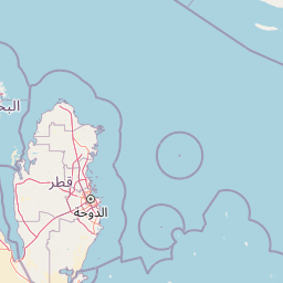
Map view of Umm Tais National Park

Use this park location map to pinpoint Umm Tais National Park in Qatar, understand its exact geographic position, and read its mapped placement within the surrounding landscape more clearly.

Pigeon | © OpenStreetMap contributors
Park atlas

Map the Geographic Spread of Island Parks and Coastal Wetlands Across Qatar's Protected Landscapes

Explore More National Parks and Coastal Protected Areas Near Umm Tais National Park

After exploring Umm Tais National Park's unique coastal island and mangrove habitats, continue your geographic discovery by browsing other protected areas in Qatar and the surrounding Gulf region. Comparing these sites offers a deeper understanding of regional conservation efforts and the diverse protected landscapes that define the Qatar Peninsula.
Biosphere reserveUnited Arab Emirates
About 53 km away#1 closest

Southwest

Al Reem Biosphere Preserve: Protected Landscape Atlas and Geographic Context

Explore mapped boundaries and biosphere reserve status.

Gain a structured understanding of Al Reem Biosphere Preserve, a designated biosphere reserve located in the United Arab Emirates. This resource focuses on its geographic identity, mapped park boundaries, and the atlas-value of understanding protected landscapes. Explore the natural terrain context and its role as a significant conservation area within the UAE, providing essential data for geographic discovery.

Area
1,200 km²
Established
2005
Relief
Lowland
Climate
Arid
Wildlife reserveQatar
About 90 km away#2 closest

South

Al Wabra Wildlife Preservation Wildlife Reserve: Geographic Atlas and Landscape Context in Qatar

Mapped protected area for atlas discovery.

Delve into the specific geographic identity of Al Wabra Wildlife Preservation, a vital wildlife reserve located in Qatar. This dedicated page offers an atlas perspective on its mapped boundaries and its role within the broader landscape of the Arabian Peninsula. Understand the protected-area context and the unique natural geography that defines this significant Qatari conservation landscape, providing a foundation for structured geographic exploration.

Area
2.5 km²
Climate
Arid
Access
Highly restricted
Scope
Terrestrial
Nature reserveDubai
About 419 km away#3 closest

East

Ras Al Khor Nature Reserve: Explore Dubai's Key Protected Landscape and Geographic Features

Mapped natural reserve boundaries and regional context in Dubai.

Delve into Ras Al Khor, a protected nature reserve offering a unique perspective on Dubai's natural geography. This detail entry focuses on its status as a protected landscape, providing clear atlas-style information about its mapped extent and its role within the regional environmental context. Understand the geographic significance of Ras Al Khor as a key area for exploring conservation landscapes within the UAE.

Area
13 km²
Established
1998
Visitors
90K annual
Relief
Lowland
National parkIran
About 436 km away#4 closest

Northeast

Bakhtegan National Park: Protected Wetland Ecosystem and Migratory Bird Sanctuary in Iran

Mapped landscape context and regional geography of Iran's vital protected area.

Bakhtegan National Park is a key protected area in Iran, historically recognized for its expansive shallow lake basin and role as a critical wetland ecosystem. This park served as a major sanctuary for migratory waterfowl, particularly flamingos and ducks, earning its designation as a Ramsar Wetland of International Importance. While facing environmental challenges, its landscape provides essential context for understanding arid region hydrology, protected land dynamics, and the geographical significance of wetland conservation within Fars province and the broader Middle East.

IUCN
II
Water
No major water
Nature reserveDubai
About 437 km away#5 closest

East

Al Marmoom Desert Conservation Reserve: Nature Reserve and Desert Landscape in Dubai

Mapped Geography and Protected Area Context

Explore the Al Marmoom Desert Conservation Reserve, a designated nature reserve located near Dubai. This protected area is crucial for understanding the region's desert geography and landscape. MoriAtlas provides detailed mapping and geographic context, allowing for in-depth study of its protected boundaries and its significance within the UAE's conservation landscape.

Area
0.4 km²
Established
2018
Relief
Lowland
Climate
Arid
Nature reserveEmirate of Dubai
About 451 km away#6 closest

East

Al Wohoosh Desert Conservation Reserve Nature Reserve: Mapped Protected Landscape

Desert terrain and geographic context in the Emirate of Dubai.

Delve into the Al Wohoosh Desert Conservation Reserve, a key protected natural area situated in the Emirate of Dubai. This entry focuses on its mapped geography, showcasing the desert landscape and its protected boundaries. Gain structured insights into its role as a nature reserve and its contribution to understanding regional conservation landscapes and mapped terrain.

Area
15.06 km²
Established
2014
Relief
Lowland
Climate
Arid
Nature reserveDubai
About 462 km away#7 closest

East

Dubai Desert Conservation Reserve: Nature Reserve, Mapped Geography, and Protected Landscape Context

Explore the natural terrain and conservation atlas of this UAE protected area.

This page details the Dubai Desert Conservation Reserve, a designated nature reserve situated within the geographic scope of Dubai, United Arab Emirates. Dive into its mapped boundaries, understand its role as a protected landscape, and gain insight into its unique natural terrain. MoriAtlas provides structured data to explore the park's place within regional geography and the broader atlas of protected areas.

Area
225 km²
Established
2003
Relief
Lowland
Climate
Arid
National parkUnited Arab Emirates
About 505 km away#8 closest

East

Wadi Wurayah National Park National Park: Mapped Protected Landscape and Geographic Context

Explore the mapped boundaries and regional geography of Wadi Wurayah National Park.

Wadi Wurayah National Park stands as a significant national park, offering a focused area for exploring protected lands. This page provides essential details about its landscape characteristics and geographic positioning, framed for atlas-driven discovery. Understand the park's protected-area identity and its contribution to regional geographic context, making it a valuable entry for anyone mapping natural landscapes or investigating conservation areas.

Common questions about visiting, size, designation, and location context for Umm Tais National Park

Umm Tais National Park FAQs for park facts, access, geography, and protected area context

Find quick answers about Umm Tais National Park, including protected-area facts, park geography, trail and visitor context, and how the park fits into its surrounding country and regional landscape.
MoriAtlas Explorer

Continue Your Protected Areas Search Across the Global Atlas

Deepen your exploration by continuing the structured search for national parks and protected areas worldwide. Utilize the comprehensive filtering capabilities to compare different conservation landscapes and refine your understanding of global park geography. Discover more about the distribution and characteristics of protected natural areas.

Global natural geography
