Mori Atlas logo
National parkWoko National Park

Navigate Woko National Park's mapped boundaries and regional geographic context within Australia.

Woko National Park: New South Wales National Park Protected Landscape and Geography

Woko National Park stands as a significant protected area within the vast landscapes of New South Wales, Australia. This page offers an atlas-driven exploration of the park's protected-area identity, providing insight into its mapped geography and landscape context. Understanding Woko National Park's place within the broader regional geography of New South Wales helps define its unique natural setting.

RainforestMountainous terrainMarsupial habitatBirdwatchingEucalyptus forestRiver ecosystems

Woko National Park

National park

Park overview

Structured park overview, official facts, and landscape profile for Woko National Park

Woko National Park park facts, protected area profile, and essential visitor context
Review the core facts for Woko National Park, including designation, size, terrain, visitor scale, habitats, and operating context in one park-focused overview.

About Woko National Park

Woko National Park occupies a significant position in the protected area network of New South Wales, offering visitors a relatively accessible wilderness experience in the foothills of the Great Dividing Range. The park's terrain is characterized by steep, jagged ridgelines and deep valleys that create a complex mosaic of microclimates and habitat types. The rainforest communities, while described as depauperate compared to tropical rainforest systems, nonetheless represent important remnant vegetation communities within a largely cleared agricultural landscape. Rocky outcrops and cliff faces provide essential habitat for rock-dwelling species, while the more open eucalyptus woodlands support a different suite of fauna. The Manning River, which flows through the park, serves as a biological corridor and provides critical aquatic habitat, with its riparian zones offering shaded picnic areas and trail access points for visitors. The park's proximity to Sydney makes it a practical destination for weekend getaways, while its wilderness character rewards those who venture beyond the more accessible river areas into the steeper interior.

Quick facts and research context for Woko National Park

Woko National Park covers 85.98 square kilometers in the Manning River catchment of New South Wales. The terrain averages 497 meters in elevation with a landscape dominated by steep ridges, valleys, and rocky escarpments. The park contains extensive rainforest areas alongside drier eucalyptus-dominated woodlands and rocky outcrop habitats. Average summer temperatures range from 16.8°C to 25.9°C, while winter temperatures span 14.4°C to 20.1°C. The Manning River bisects the park, supporting riparian ecosystems and providing recreational access points.

Park context

Deeper park guide and search-rich context for Woko National Park

Woko National Park history, landscape, wildlife, and travel context
Explore Woko National Park through its history, landscape character, ecosystems, wildlife, conservation priorities, cultural context, and seasonal travel timing in a structured park guide built for atlas discovery and search intent.

Why Woko National Park stands out

Woko National Park is best known for its dramatic combination of depauperate rainforest, exposed rocky ridgelines, and eucalyptus forests within a relatively compact wilderness area. The park protects important populations of threatened wildlife, including the brush-tailed rock-wallaby, and provides habitat for iconic Australian bird species such as the lyrebird and wedge-tailed eagle. The contrast between the lush, shaded rainforest gullies and the more open, arid rocky sections creates a distinctive visual and ecological character that distinguishes Woko from other New South Wales national parks.

Woko National Park history and protected-area timeline

Woko National Park was established in 1982, designated under the National Parks and Wildlife Act to protect the unique combination of rainforest, woodland, and rocky landscape in the Manning River catchment. The establishment of the park reflected growing recognition in the latter decades of the twentieth century of the importance of protecting remnant vegetation communities in New South Wales, particularly those containing significant biodiversity values or representing unusual ecological assemblages. The park was placed under the management of the NSW National Parks and Wildlife Service, which continues to oversee conservation, visitor facilities, and fire management within the reserve. The formal protection of this area came during a period when national park establishment in New South Wales was expanding to include smaller but ecologically significant reserves that complemented the larger wilderness parks of the state.

Woko National Park landscape and geographic character

The landscape of Woko National Park presents a dramatically uneven terrain typical of the foothills region of the Great Dividing Range in northern New South Wales. Steep ridgelines rise from narrow valleys, creating an exposed and rugged character throughout much of the park. The geology supports a variety of landforms including rocky outcrops, cliff faces, and boulder-strewn slopes. Rainforest occupies the more protected gullies and lower slopes where moisture accumulates, forming dark, shaded pockets of dense vegetation that contrast sharply with the more open eucalyptus-covered ridges. The Manning River has carved a valley through the park, creating gentler terrain along its floodplain where visitor facilities and access points are concentrated. The elevation range across the park supports different vegetation zones, with the higher ridgelines experiencing different temperature and moisture regimes than the valley floors.

Woko National Park ecosystems, habitats, and plant life

The ecological character of Woko National Park is defined by the interplay between wet rainforest communities and drier sclerophyll forest and woodland environments. The rainforest communities, though not as species-rich as their tropical counterparts, represent significant remnants of historical forest types that once covered more of this region. These forests provide shade, moisture retention, and structural complexity that supports a distinct set of species. The surrounding eucalyptus woodlands and grassy areas add diversity to the park's vegetation, creating a mosaic that supports varied wildlife. The rocky outcrops and cliff faces provide specialized habitats for species adapted to exposed conditions, while the Manning River corridor connects these different habitat types and supports riparian vegetation and aquatic communities.

Woko National Park wildlife and species highlights

Woko National Park supports a notable diversity of bird and animal species within its varied habitats. The lyrebird, one of Australia's most iconic ground-dwelling birds, inhabits the forest floor and is known for its remarkable ability to mimic the calls of other birds and mechanical sounds. The wedge-tailed eagle, a large raptor species, soars above the ridgelines and open areas, hunting over the woodland and grassland zones. The brush-tailed rock-wallaby, a threatened marsupial species, finds refuge among the rocky outcrops and cliff faces that provide shelter and suitable habitat for this agile climber. The combination of forest, woodland, grassland, and rocky habitats creates a landscape that supports multiple ecological niches, and the river corridor adds further habitat diversity. The park's position within a largely cleared agricultural landscape means it serves as an important refuge for wildlife in the broader region.

Woko National Park conservation status and protection priorities

Woko National Park plays a significant conservation role by protecting a representative sample of the ecological communities that characterize the Manning River catchment region. The park preserves habitat for threatened species including the brush-tailed rock-wallaby, providing essential refuges in a landscape where native vegetation has been extensively cleared for agriculture. The protection of the Manning River corridor within the park safeguards water quality and aquatic habitat, contributing to broader catchment health. The rainforest communities, while depauperate, represent historical vegetation types that have been largely removed from the surrounding landscape, making their protection within the park particularly valuable. The reserve also serves as a biological corridor, connecting remnant vegetation and allowing wildlife movement through a fragmented rural landscape.

Woko National Park cultural meaning and human context

Woko National Park sits within the traditional lands of Aboriginal peoples, though the source material does not provide specific details about indigenous connections to this landscape. The broader Manning River region has historical significance for local Aboriginal communities, and the river corridor would have provided resources and travel routes historically. The park's establishment in 1982 represents a more recent phase of formal conservation recognition, building on earlier protection efforts in New South Wales.

Top sights and standout views in Woko National Park

The dramatic ridgeline scenery of Woko National Park, with its exposed rocky faces and steep valleys, offers a distinctive visual experience within the New South Wales protected area network. The contrast between the dark, lush rainforest gullies and the more open eucalyptus ridges creates a park of considerable scenic diversity. The Manning River provides a focal point for visitor activities, with riverside areas offering accessible picnicking and walking opportunities. The wildlife viewing opportunities, particularly for lyrebirds and rock-wallabies, distinguish this park from more accessible but less wild reserves closer to Sydney.

Best time to visit Woko National Park

Woko National Park can be visited year-round, with different seasons offering distinct experiences. The cooler winter months from May through September typically provide more comfortable conditions for hiking and bushwalking, with clearer skies and less humidity. Summer months from December to February bring warmer temperatures, with the rainforest gullies offering cooler shade during hot spells, though the open ridgelines can become quite hot. The Manning River is a focal point in all seasons, though river levels and access may vary with seasonal rainfall patterns. Autumn and spring often provide pleasant conditions for walking and wildlife observation, with moderate temperatures and generally stable weather patterns.
Park location guide

Geography guide, regional context, and park location map for Woko National Park

Woko National Park park geography, regions, and map view in Australia
Understand where Woko National Park sits in Australia through a broader geographic reading of the surrounding landscape, nearby location context, and its mapped position within the national park landscape.

How Woko National Park fits into Australia

Australia is a constitutional monarchy and federal parliamentary democracy comprising six states and ten territories. With a population of nearly 28 million, it is one of the world's most urbanised countries, with most people concentrated on the eastern seaboard. The country has a high Human Development Index and is known for its cultural diversity, ancient Aboriginal heritage, and unique wildlife.

Wider geography shaping Woko National Park in Australia

Australia occupies the entire Australian continent, the island of Tasmania, and numerous smaller islands. It is the world's flattest and driest inhabited continent, featuring vast deserts in the interior (the Outback), tropical rainforests along the eastern coast, and a coastline bordering the Indian and Pacific Oceans.

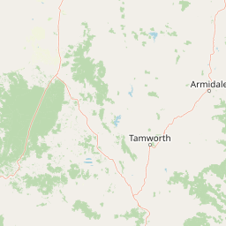
Map view of Woko National Park

Use this park location map to pinpoint Woko National Park in Australia, understand its exact geographic position, and read its mapped placement within the surrounding landscape more clearly.

Pigeon | © OpenStreetMap contributors

Location context for Woko National Park

New South Wales
Park atlas

Trace the Geographic Spread of Protected Landscapes in the Greater Hunter Region and Beyond Woko National Park's Borders

Explore Other National Parks and Protected Areas Near Woko National Park, New South Wales
Continue your exploration of national parks and protected areas surrounding Woko National Park, comparing diverse landscapes across the Greater Hunter region of New South Wales, Australia. Trace the geographic spread of rainforests, eucalyptus forests, and rugged mountain terrain to understand the broader conservation context and unique ecological communities within Eastern Australia.
National parkNew South Wales

Barakee National Park: New South Wales Protected Landscape Atlas Explorer

Mapped Boundaries and Regional Geography Insights

Barakee National Park is a vital component of New South Wales's protected natural areas, offering a focused point for geographic discovery. This page provides key details on its protected landscape identity and its place within the mapped terrain of the region. Examine the structured data to grasp the park's geographic footprint and understand its significance as a designated national park within Australia.

Area
50.11 km²
Established
1999
IUCN
II
Relief
Mixed relief
National parkMid North Coast

Tapin Tops National Park: Protected Landscape in Mid North Coast, Australia

Mapped geographic context and natural terrain discovery.

Tapin Tops National Park is a designated national park offering rich opportunities for geographic and landscape exploration. This detail page provides a structured look at its protected area status and its location within the Mid North Coast region of Australia. Delve into the mapped boundaries and understand the park's specific natural terrain for comprehensive atlas-based discovery.

Area
110 km²
Established
1999
IUCN
II
Relief
Mountain
Watercolor illustration of a river flowing through hills with distant mountains and pink trees
National parkNew South Wales

Barrington Tops National Park: A Protected National Park in New South Wales

Explore ancient Gondwana rainforests and dramatic volcanic terrain.

Barrington Tops National Park represents a significant protected landscape in New South Wales, Australia, offering a deep dive into diverse ecosystems. Its unique altitudinal vegetation gradient supports the southernmost subtropical rainforests in Australia and showcases geological formations dating back millions of years. This park is crucial for understanding Australia's natural heritage, providing a rich context for landscape exploration and the study of ancient flora within a mapped geographic setting.

Area
765.12 km²
Established
1969
IUCN
Ib
Relief
Mountain
National parkNew South Wales

Mummel Gulf National Park: New South Wales Protected Area & Mapped Gorge Landscape

Rugged escarpment terrain with diverse forest ecosystems.

Mummel Gulf National Park is a protected area in New South Wales, Australia, renowned for its dramatic V-shaped gorge carved by the Mummel River, reaching depths over 400 metres. This rugged escarpment landscape hosts a variety of vegetation communities, including tall open eucalypt, wet sclerophyll, snow gum forests, and subtropical rainforest patches. The park's geography is central to its ecological significance, providing habitat for numerous species and showcasing a distinct natural terrain within the New England region, ideal for geographic exploration.

Area
122 km²
Established
1999
IUCN
II
Relief
Mountain
National parkNew South Wales

Cottan-Bimbang National Park: A Protected Landscape in New South Wales

Explore its mapped boundaries and regional geographic context.

Delve into the protected landscape of Cottan-Bimbang National Park, a key national park situated in New South Wales, Australia. This page provides detailed insight into its geographic setting and mapped park boundaries, offering a clear understanding of its regional importance. Discover the distinct natural landscape characteristics that define Cottan-Bimbang National Park within the broader Australian atlas.

Area
269 km²
Established
1999
IUCN
II
Climate
Temperate
National parkNew South Wales

Biriwal Bulga National Park: Protected Landscape and Geographic Context within New South Wales

Explore mapped boundaries and the national park's regional setting.

Biriwal Bulga National Park represents a significant protected area within New South Wales, Australia, offering crucial insights into the region's natural landscape geography. This dedicated page details the park's specific identity as a national park, focusing on its mapped geographic boundaries and its contribution to the broader atlas of protected lands. It is designed for users who require structured information about individual protected areas and their precise location and landscape context.

Area
65.28 km²
Established
1999
IUCN
II
Relief
Lowland
National parkNew South Wales

Ben Halls Gap National Park: Ancient Eucalyptus Forest Protected Landscape in New South Wales

Explore mapped boundaries of old-growth woodland terrain.

Ben Halls Gap National Park represents an ecologically vital strict nature reserve within New South Wales, Australia. It is distinguished by its extensive ancient eucalyptus forests, which are among the most ecologically significant old-growth woodland environments in eastern Australia. Managed primarily for conservation and research, the park's rugged terrain provides a critical habitat refuge and a key reference ecosystem for understanding undisturbed woodland dynamics and biodiversity.

Area
30.18 km²
Established
1995
IUCN
Ia
Scope
Terrestrial
National parkNew South Wales

Mount Royal National Park: A National Park in New South Wales for Geographic Discovery

Explore its protected boundaries and landscape context.

Mount Royal National Park is a key protected area in New South Wales, offering an opportunity to delve into its specific geographic identity and mapped landscape features. As a national park, it provides structured data for understanding protected lands within Australia. This detailed entry supports exploration of the park's unique regional context and its contribution to the broader atlas of natural landscapes.

Area
69 km²
Established
1997
IUCN
II
Relief
Mountain

Common questions about visiting, size, designation, and location context for Woko National Park

Woko National Park FAQs for park facts, access, geography, and protected area context
Find quick answers about Woko National Park, including protected-area facts, park geography, trail and visitor context, and how the park fits into its surrounding country and regional landscape.
MoriAtlas Explorer

Continue Your Protected Areas Search Across the Global Atlas

Deepen your exploration by continuing the structured search for national parks and protected areas worldwide. Utilize the comprehensive filtering capabilities to compare different conservation landscapes and refine your understanding of global park geography. Discover more about the distribution and characteristics of protected natural areas.

Global natural geography