

Mori Atlas logo
National parkBarakee National Park

Understand the mapped boundaries and regional geography of this key Australian national park.

Barakee National Park: New South Wales Protected Landscape & Geographic Context

Barakee National Park stands as a significant protected area within the diverse geography of New South Wales. This national park offers a clear focus for exploring mapped protected lands and understanding its specific role in the regional landscape context. Delve into the structured geographic information and atlas-style details that define Barakee National Park, providing a factual foundation for its exploration.

ecological corridoreucalypt forestold-growth forestrainforestthreatened speciesNew South Wales

Barakee National Park

National park

Park overview

Structured park overview, official facts, and landscape profile for Barakee National Park

Barakee National Park park facts, protected area profile, and essential visitor context
Review the core facts for Barakee National Park, including designation, size, terrain, visitor scale, habitats, and operating context in one park-focused overview.

About Barakee National Park

Barakee National Park represents an important protected area in the Mid North Coast region of New South Wales, Australia. The park and its adjacent State Conservation Area work together to form a continuous protected landscape that serves as a biological corridor between the lowland ecosystems of the Manning River floodplain and the montane forests of the Great Dividing Range. This corridor function is ecologically significant because it allows for species migration, genetic exchange between populations, and seasonal movement patterns that many forest-dwelling species depend upon. The park's diverse topography and variable climate zones support an exceptional diversity of forest types and vegetation communities within a relatively compact area. The protected status of Barakee ensures that these forest ecosystems remain intact despite surrounding land clearing for agriculture and development. The park offers opportunities for camping, swimming, fishing, hiking, and four-wheel driving, though its remote location means it attracts fewer visitors than more accessible parks in the region. This relative obscurity contributes to the park's natural character and provides a more secluded wilderness experience for those who do visit.

Quick facts and research context for Barakee National Park

Barakee National Park occupies 50.11 square kilometers in the Hunter Region of New South Wales, Australia, at coordinates 31°38′30″S 151°51′06″E. The park was formally established in 1999 and is classified as an IUCN Category II protected area, managed by the National Parks and Wildlife Service. The landscape transitions from lowland floodplain environments up into montane forests of the Great Dividing Range, creating a unique ecological gradient that supports diverse vegetation communities including old-growth forest and rainforest habitats. The park is notable for its high diversity of eucalypt species and its role as a refuge for several threatened animal species.

Park context

Deeper park guide and search-rich context for Barakee National Park

Barakee National Park history, landscape, wildlife, and travel context
Explore Barakee National Park through its history, landscape character, ecosystems, wildlife, conservation priorities, cultural context, and seasonal travel timing in a structured park guide built for atlas discovery and search intent.

Why Barakee National Park stands out

Barakee National Park is best known for its role as a critical ecological corridor that connects the Manning River floodplain with the Great Dividing Range, creating a continuous protected pathway for wildlife movement across varying elevations and habitat types. The park contains significant old-growth forest and rainforest habitats, which are increasingly rare in the region, and supports one of the more diverse eucalypt forest assemblages in northern New South Wales. It also serves as habitat for several threatened species including the glossy black-cockatoo, koala, and eastern bentwing-bat. The park's relative remoteness means it receives fewer visitors than many other Australian national parks, preserving a more natural and undisturbed wilderness character.

Barakee National Park history and protected-area timeline

Barakee National Park was established in 1999 through the formal gazettal of the area as a national park under the National Parks and Wildlife Act of New South Wales. The creation of the park represented recognition of the ecological importance of the corridor connecting the Manning River floodplain with the Great Dividing Range, an area that had previously lacked formal protection despite its biodiversity value. The park was created alongside the adjacent Barakee State Conservation Area, which extends the protected zone and provides additional buffer habitat. In recent years, the park experienced significant environmental disturbance from the bushfires of 2019 and 2020, which left scars across portions of the landscape. These fires necessitated the closure of some areas to allow for habitat recovery and infrastructure renewal, reflecting the ongoing challenges that Australian protected areas face from climate-related fire events.

Barakee National Park landscape and geographic character

The landscape of Barakee National Park encompasses a transition zone from the flat, fertile floodplain of the Manning River up into the forested slopes of the Great Dividing Range. This topographic gradient creates diverse terrain including gentle rolling hills in the lower elevations, steeper ridgelines as the land rises, and various aspects and microclimates that contribute to the variety of vegetation communities present. The park contains creek lines and drainage systems that carry water from the higher ground down to the floodplain, providing riparian corridors within the forest. The forest canopy varies from tall eucalypt forests on the slopes to more sheltered rainforest gullies in the protected valleys, creating a mosaic of forest types across the park. Old-growth forest patches remain in several areas, representing remnants of the original forest cover that existed before European settlement and logging activities altered much of the surrounding landscape.

Barakee National Park ecosystems, habitats, and plant life

The vegetation of Barakee National Park is characterized by exceptional diversity, with numerous eucalypt species dominating the canopy alongside significant rainforest understory elements in sheltered positions. The dominant tree species include Sydney blue gum, forest red gum, river oak, thin-leaved stringybark, tallowwood, several grey gum species, white mahogany, pink bloodwood, broad-leaved apple, and apple box. This assemblage represents one of the more species-rich eucalypt forest communities in the region. The park also supports old-growth forest remnants, which are ecologically valuable as they provide habitat structures, dead wood, and microhabitats that younger forests cannot replicate. Rainforest habitats occur in protected gullies and south-facing slopes where moisture levels are higher, adding to the botanical diversity. The ecological corridor function of the park is particularly important for maintaining connectivity between lowland and highland species populations.

Barakee National Park wildlife and species highlights

Barakee National Park supports several threatened animal species that depend on the diverse forest habitats found within the protected area. The glossy black-cockatoo is a distinctive species that inhabits the eucalypt forests, feeding on the seeds of various tree species and using hollows in mature trees for nesting. Both the scarlet robin and flame robin are small passerine birds that occupy different strata of the forest, from the understory to the canopy. The koala is present in the eucalypt forests, relying on specific tree species for foraging and resting. The eastern false pipistrelle is a microbat species that hunts insects within the forest, using tree hollows and crevices for roosting. The eastern bentwing-bat is another bat species that utilizes the diverse forest habitats for foraging and shelter. This collection of threatened species demonstrates the conservation significance of the park's diverse forest ecosystems.

Barakee National Park conservation status and protection priorities

Barakee National Park plays a significant conservation role in the region as a protected area that maintains ecological connectivity across a landscape gradient. The ecological corridor linking the Manning River floodplain to the Great Dividing Range enables species movement and genetic exchange that would otherwise be prevented by cleared agricultural land. The old-growth forest and rainforest habitats within the park represent some of the last remaining examples of these forest types in the region, as much of the surrounding landscape has been cleared or modified. The presence of multiple threatened species indicates that the park provides important habitat for species that have suffered population declines across their range. Conservation management focuses on maintaining habitat quality, protecting old-growth elements, and managing fire impacts to allow ecosystem recovery.

Barakee National Park cultural meaning and human context

Barakee National Park is situated within the traditional lands of Aboriginal peoples, though the specific tribal affiliations and cultural history of the area are not extensively detailed in available sources. The landscape would have supported Aboriginal communities for thousands of years prior to European settlement, with the Manning River floodplain and the forested slopes of the Great Dividing Range providing diverse resources and cultural connections. The ecological corridor concept, while framed in modern conservation terminology, reflects a landscape that historically supported continuous movement and habitation across this terrain gradient.

Top sights and standout views in Barakee National Park

The ecological corridor connecting the Manning River floodplain to the Great Dividing Range is the defining feature of Barakee National Park, providing connectivity across diverse habitats and elevations. The park contains significant old-growth forest and rainforest remnants that are increasingly rare in the cleared agricultural landscape of northern New South Wales. Multiple threatened species including glossy black-cockatoo, koala, and eastern bentwing-bat rely on the protected forest habitats. The park remains relatively remote and uncrowded, offering a more secluded natural experience compared to more accessible Australian national parks. Camping, swimming, fishing, hiking, and four-wheel driving provide visitor activities.

Best time to visit Barakee National Park

The best time to visit Barakee National Park depends on the experience sought, with autumn and spring generally offering mild temperatures and comfortable conditions for hiking and outdoor activities. Summer months can bring hot conditions in this region of New South Wales, while winter may be cooler but still suitable for day visits. The park's remote character means that visitor numbers remain low throughout the year, so flexibility in timing is possible. Those interested in wildlife viewing may find different species more active during cooler parts of the day in warmer months. Visitors should check current conditions before traveling, as areas may remain closed following fire damage from 2019-2020 to allow for habitat recovery.
Park location guide

Geography guide, regional context, and park location map for Barakee National Park

Barakee National Park park geography, regions, and map view in Australia
Understand where Barakee National Park sits in Australia through a broader geographic reading of the surrounding landscape, nearby location context, and its mapped position within the national park landscape.

How Barakee National Park fits into Australia

Australia is a constitutional monarchy and federal parliamentary democracy comprising six states and ten territories. With a population of nearly 28 million, it is one of the world's most urbanised countries, with most people concentrated on the eastern seaboard. The country has a high Human Development Index and is known for its cultural diversity, ancient Aboriginal heritage, and unique wildlife.

Wider geography shaping Barakee National Park in Australia

Australia occupies the entire Australian continent, the island of Tasmania, and numerous smaller islands. It is the world's flattest and driest inhabited continent, featuring vast deserts in the interior (the Outback), tropical rainforests along the eastern coast, and a coastline bordering the Indian and Pacific Oceans.

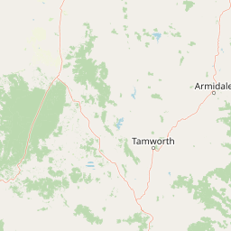
Map view of Barakee National Park

Use this park location map to pinpoint Barakee National Park in Australia, understand its exact geographic position, and read its mapped placement within the surrounding landscape more clearly.

Pigeon | © OpenStreetMap contributors

Location context for Barakee National Park

New South Wales
Park atlas

Trace interconnected protected landscapes and forest corridors within Northern New South Wales

Explore Nearby National Parks and Protected Areas Surrounding Barakee National Park
After exploring Barakee National Park, browse other national parks and protected areas found within the surrounding region of Northern New South Wales, Australia. This geographic context enables comparative atlas exploration of diverse forest landscapes, vital ecological corridors, and connected conservation efforts across the wider territory.
National parkNew South Wales

Woko National Park: Explore Its Protected Landscape and Geographic Boundaries

Discover the mapped terrain and regional atlas context of Woko National Park.

Woko National Park presents a unique opportunity for geographic discovery, situated within New South Wales, Australia. This detail page focuses on the park's protected landscape and its mapped boundaries, providing a clear understanding of its geographic identity. Engage with Woko National Park as a key component of the Australian national park atlas, highlighting its regional setting and natural terrain.

Area
85.98 km²
Established
1982
IUCN
II
Relief
Highland
National parkMid North Coast

Tapin Tops National Park: Protected Landscape in Mid North Coast, Australia

Mapped geographic context and natural terrain discovery.

Tapin Tops National Park is a designated national park offering rich opportunities for geographic and landscape exploration. This detail page provides a structured look at its protected area status and its location within the Mid North Coast region of Australia. Delve into the mapped boundaries and understand the park's specific natural terrain for comprehensive atlas-based discovery.

Area
110 km²
Established
1999
IUCN
II
Relief
Mountain
National parkNew South Wales

Mummel Gulf National Park: New South Wales Protected Area & Mapped Gorge Landscape

Rugged escarpment terrain with diverse forest ecosystems.

Mummel Gulf National Park is a protected area in New South Wales, Australia, renowned for its dramatic V-shaped gorge carved by the Mummel River, reaching depths over 400 metres. This rugged escarpment landscape hosts a variety of vegetation communities, including tall open eucalypt, wet sclerophyll, snow gum forests, and subtropical rainforest patches. The park's geography is central to its ecological significance, providing habitat for numerous species and showcasing a distinct natural terrain within the New England region, ideal for geographic exploration.

Area
122 km²
Established
1999
IUCN
II
Relief
Mountain
National parkNew South Wales

Cottan-Bimbang National Park: A Protected Landscape in New South Wales

Explore its mapped boundaries and regional geographic context.

Delve into the protected landscape of Cottan-Bimbang National Park, a key national park situated in New South Wales, Australia. This page provides detailed insight into its geographic setting and mapped park boundaries, offering a clear understanding of its regional importance. Discover the distinct natural landscape characteristics that define Cottan-Bimbang National Park within the broader Australian atlas.

Area
269 km²
Established
1999
IUCN
II
Climate
Temperate
National parkNew South Wales

Biriwal Bulga National Park: Protected Landscape and Geographic Context within New South Wales

Explore mapped boundaries and the national park's regional setting.

Biriwal Bulga National Park represents a significant protected area within New South Wales, Australia, offering crucial insights into the region's natural landscape geography. This dedicated page details the park's specific identity as a national park, focusing on its mapped geographic boundaries and its contribution to the broader atlas of protected lands. It is designed for users who require structured information about individual protected areas and their precise location and landscape context.

Area
65.28 km²
Established
1999
IUCN
II
Relief
Lowland
Watercolor illustration of a river flowing through hills with distant mountains and pink trees
National parkNew South Wales

Barrington Tops National Park: A Protected National Park in New South Wales

Explore ancient Gondwana rainforests and dramatic volcanic terrain.

Barrington Tops National Park represents a significant protected landscape in New South Wales, Australia, offering a deep dive into diverse ecosystems. Its unique altitudinal vegetation gradient supports the southernmost subtropical rainforests in Australia and showcases geological formations dating back millions of years. This park is crucial for understanding Australia's natural heritage, providing a rich context for landscape exploration and the study of ancient flora within a mapped geographic setting.

Area
765.12 km²
Established
1969
IUCN
Ib
Relief
Mountain
National parkNew South Wales

Werrikimbe National Park National Park: Mapped Boundaries and Protected Landscape

Explore the geographic setting and regional context within New South Wales.

Werrikimbe National Park represents a critical element within the geographic tapestry of New South Wales, Australia. As a national park, it signifies a protected land offering valuable insights into regional terrain and landscape characteristics. Users exploring the MoriAtlas can investigate its mapped features, understand its protected status, and place it within the wider context of Australian natural geography and conservation landscapes.

Area
333 km²
Established
1975
IUCN
Ib
Relief
Mountain
National parkNew South Wales

Ben Halls Gap National Park: Ancient Eucalyptus Forest Protected Landscape in New South Wales

Explore mapped boundaries of old-growth woodland terrain.

Ben Halls Gap National Park represents an ecologically vital strict nature reserve within New South Wales, Australia. It is distinguished by its extensive ancient eucalyptus forests, which are among the most ecologically significant old-growth woodland environments in eastern Australia. Managed primarily for conservation and research, the park's rugged terrain provides a critical habitat refuge and a key reference ecosystem for understanding undisturbed woodland dynamics and biodiversity.

Area
30.18 km²
Established
1995
IUCN
Ia
Scope
Terrestrial

Common questions about visiting, size, designation, and location context for Barakee National Park

Barakee National Park FAQs for park facts, access, geography, and protected area context
Find quick answers about Barakee National Park, including protected-area facts, park geography, trail and visitor context, and how the park fits into its surrounding country and regional landscape.
MoriAtlas Explorer

Continue Your Protected Areas Search Across the Global Atlas

Deepen your exploration by continuing the structured search for national parks and protected areas worldwide. Utilize the comprehensive filtering capabilities to compare different conservation landscapes and refine your understanding of global park geography. Discover more about the distribution and characteristics of protected natural areas.

Global natural geography