

Mori Atlas logo
National parkAlexander Morrison National Park

Discover mapped park boundaries and regional geographic context within the Australian atlas.

Alexander Morrison National Park: Western Australia's Protected Landscape Atlas

Alexander Morrison National Park stands as a significant protected area within the vast geographic expanse of Western Australia. As a designated national park, its mapped boundaries define a unique protected landscape contributing to the state's diverse natural heritage. This page serves as an entry point for understanding the park's place within the regional geography and exploring its protected land identity through structured atlas-style discovery.

sandplain ecosystemsheathland habitatsWestern Australiabotanical legacylateritic breakawaysJuras

Alexander Morrison National Park

National park

Park overview

Structured park overview, official facts, and landscape profile for Alexander Morrison National Park

Alexander Morrison National Park park facts, protected area profile, and essential visitor context
Review the core facts for Alexander Morrison National Park, including designation, size, terrain, visitor scale, habitats, and operating context in one park-focused overview.

About Alexander Morrison National Park

Alexander Morrison National Park protects a significant tract of sandplain and heathland ecosystem in the southwestern corner of Western Australia. Located along the Green Head-Coorow Road in the Shire of Coorow, the park lies approximately 207 kilometres north of Perth, making it accessible for day visits from the metropolitan area while retaining a remote and uncrowded character. The park's 8,500 hectares encompass a geological landscape shaped by ancient Jurassic sediments, with lateritic breakaways rising above sandplain terrain. The vegetation reflects the park's position within the Southwest Australia Floristic Region, one of the world's biodiversity hotspots. Sand heaths dominate the landscape, providing habitat for numerous endemic plant species. The park also contains substantial areas of low woodland and mallee, particularly in western sections, where eucalypts such as Powder-barked Wandoo and Mallalie form distinctive canopy layers. The combination of ancient geology, specialized soils, and Mediterranean climate has produced a flora of exceptional scientific and conservation significance.

Quick facts and research context for Alexander Morrison National Park

Alexander Morrison National Park covers 85 square kilometres of sandplain and lateritic terrain in coastal Western Australia, approximately 207 kilometres north of Perth. The park was established in 1970 and named to honor Alexander Morrison, the first Government Botanist of Western Australia. The terrain consists of sandplains with low breakaways formed over Jurassic-era sandstone and shale formations. Vegetation is dominated by sand heaths with scattered low woodland and mallee, featuring eucalypt species such as Powder-barked Wandoo and Mallalie.

Park context

Deeper park guide and search-rich context for Alexander Morrison National Park

Alexander Morrison National Park history, landscape, wildlife, and travel context
Explore Alexander Morrison National Park through its history, landscape character, ecosystems, wildlife, conservation priorities, cultural context, and seasonal travel timing in a structured park guide built for atlas discovery and search intent.

Why Alexander Morrison National Park stands out

The park is best known for its extensive sand heaths, which form one of the most characteristic vegetation types of the southwestern Australian biodiversity hotspot. The heaths support a remarkable diversity of plant species, including the rare spiral bush (Spirogardnera rubescens) and a northern variant of Banksia vestita. The park preserves representative examples of the Lower Jurassic Cockleshell Gully Formation geology, with its distinctive lateritic breakaways and sandplain topography. It also represents the legacy of Alexander Morrison, the pioneering first Government Botanist of Western Australia whose work helped document the state's unique flora.

Alexander Morrison National Park history and protected-area timeline

The land comprising Alexander Morrison National Park was set aside by the Department of Lands and Surveys in May 1969 under Reserves 26800, 26803, and 26804. Over the course of 1970 and 1971, the land was classified as an 'A' Class reserve, the highest level of protection in Western Australia, meaning its purpose could not be changed except by an Act of Parliament. The reserve was formally vested in the National Parks Authority of Western Australia, and the park was officially named on 8 October 1971 to honor Alexander Morrison, who served as the first Government Botanist of Western Australia and made significant contributions to the documentation and understanding of the state's unique flora. In 1974, the Environmental Protection Authority recommended that a one-kilometre-wide strip of vacant Crown land on the southern side of the Green Head-Coorow Road be added to the reserve to enhance protection, though this expansion was never implemented.

Alexander Morrison National Park landscape and geographic character

The park's landscape is characterized by extensive sandplains punctuated by low lateritic breakaways, creating a gently undulating terrain distinctive of the western Australian wheatbelt region. The underlying geology consists of sandstone and shale formations belonging to the Lower Jurassic Cockleshell Gully Formation, some 180 million years old. Over geological time, weathering processes have produced laterite caps on the older rock formations, creating the breakaway topography visible throughout the park. The sandy soils supporting the heaths are nutrient-poor and have contributed to the evolution of specialized plant adaptations. The landscape lacks prominent water features but supports vegetation communities adapted to the Mediterranean climate with wet winters and dry summers. The combination of ancient geological substrates, mineral-poor soils, and semi-arid conditions has produced a landscape of considerable scientific interest.

Alexander Morrison National Park ecosystems, habitats, and plant life

The nature of Alexander Morrison National Park centers on its sand heath communities, which represent one of the most species-rich vegetation types in Australia. These heaths occur on sandy soils derived from the underlying Jurassic formations and support an extraordinarily diverse flora adapted to the low-nutrient, well-drained substrates. The park's heaths are particularly notable for their high endemism, with many species found nowhere else on Earth. Beyond the heaths, the park contains extensive low woodland and mallee communities, especially in western areas, where species such as Powder-barked Wandoo and Mallalie dominate. The park's position within the Southwest Australia Floristic Region places it within one of the world's 36 biodiversity hotspots, recognizing the exceptional concentration of endemic species found in this region. The vegetation patterns reflect the park's Mediterranean climate, with many species exhibiting drought-adapted characteristics and seasonal flowering patterns tied to the wet winter growing season.

Alexander Morrison National Park wildlife and species highlights

While the Wikipedia source focuses primarily on the park's botanical values, the southwestern Australian sandplain and heathland environments are known to support diverse wildlife communities. The park's heath and woodland habitats provide shelter and foraging resources for numerous bird species, reptiles, and small mammals adapted to the Mediterranean environment. The dense heath vegetation offers ground-dwelling species protection from predators and extreme temperatures, while flowering plants provide seasonal nectar and pollen resources for insects and birds. The mallee and woodland areas provide nesting sites and foraging habitat for various bird species. The region's isolation and unique ecological conditions have produced distinctive wildlife assemblages with high levels of endemic species, though detailed wildlife inventories would require supplementary sources beyond the provided material.

Alexander Morrison National Park conservation status and protection priorities

Alexander Morrison National Park represents an important conservation reserve within the southwestern Australian biodiversity hotspot. The park's 'A' Class reserve status provides the highest level of legal protection available in Western Australia, ensuring the preservation of its sandplain and heathland ecosystems in perpetuity. The park conserves representative examples of the Lower Jurassic Cockleshell Gully Formation geology and associated landforms, including the lateritic breakaways that characterize the landscape. The heath communities harbor rare species including spiral bush (Spirogardnera rubescens) and the northern variant of Banksia vestita, both of which receive protection within the reserve. The 1974 Environmental Protection Authority recommendation to expand the park indicates recognition of its conservation significance, though the proposed addition of Crown land was not implemented. The park contributes to the broader conservation network protecting southwestern Australia's unique Mediterranean-climate ecosystems.

Alexander Morrison National Park cultural meaning and human context

The park is named for Alexander Morrison, who served as the first Government Botanist of Western Australia from 1895 to 1907. Morrison made substantial contributions to the documentation and classification of Western Australia's flora, establishing the scientific foundation for understanding the state's unique plant diversity. His work during the colonial period helped document many species previously unknown to science and contributed to the recognition of the southwestern Australian region as botanically significant. The park's naming preserves this scientific legacy while also protecting the landscapes that Morrison would have studied during his botanical surveys of the region. The park lies within the traditional lands of the Yuat people, though the Wikipedia source does not provide detailed information about indigenous connections to the area.

Top sights and standout views in Alexander Morrison National Park

The park's highlights include its extensive sand heaths supporting rare plant species, the geological significance of the Jurassic Cockleshell Gully Formation with its lateritic breakaways, and the legacy of Alexander Morrison as the park's namesake. Visitors experience a landscape of sandy heathlands and low woodland that exemplifies the southwestern Australian wheatbelt environment. The diverse flora includes distinctive eucalypts such as Powder-barked Wandoo and Mallalie, along with rare species like spiral bush. The park offers a relatively uncrowded nature experience compared to more heavily visited southwestern Australian parks, with opportunities for exploring the sandplain landscapes along the Green Head-Coorow Road that borders the reserve.

Best time to visit Alexander Morrison National Park

The best time to visit Alexander Morrison National Park is during the cooler months of autumn and winter, from April through September, when temperatures are mild and the park's heaths are likely to display seasonal flowering. The Mediterranean climate means that winter brings rainfall that triggers the main growing and flowering season for many heath species. Spring, particularly late winter through early summer, can offer excellent wildflower viewing as the heath communities come into bloom. Summer months (December through February) bring hotter, drier conditions that may limit wildlife activity and make exploration less comfortable, though the park remains accessible year-round. The park's location along the Green Head-Coorow Road makes it accessible for day trips from Perth, though the 207-kilometre journey requires planning for those wishing to visit.
Park location guide

Geography guide, regional context, and park location map for Alexander Morrison National Park

Alexander Morrison National Park park geography, regions, and map view in Australia
Understand where Alexander Morrison National Park sits in Australia through a broader geographic reading of the surrounding landscape, nearby location context, and its mapped position within the national park landscape.

How Alexander Morrison National Park fits into Australia

Australia is a constitutional monarchy and federal parliamentary democracy comprising six states and ten territories. With a population of nearly 28 million, it is one of the world's most urbanised countries, with most people concentrated on the eastern seaboard. The country has a high Human Development Index and is known for its cultural diversity, ancient Aboriginal heritage, and unique wildlife.

Wider geography shaping Alexander Morrison National Park in Australia

Australia occupies the entire Australian continent, the island of Tasmania, and numerous smaller islands. It is the world's flattest and driest inhabited continent, featuring vast deserts in the interior (the Outback), tropical rainforests along the eastern coast, and a coastline bordering the Indian and Pacific Oceans.

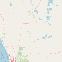
Map view of Alexander Morrison National Park

Use this park location map to pinpoint Alexander Morrison National Park in Australia, understand its exact geographic position, and read its mapped placement within the surrounding landscape more clearly.

Pigeon | © OpenStreetMap contributors

Location context for Alexander Morrison National Park

Western Australia
Park atlas

Trace the sandplain ecosystems and unique heathland habitats of Western Australia, comparing conservation landscapes across the region.

Explore Nearby National Parks and Protected Areas Beyond Alexander Morrison National Park
Explore other national parks and protected areas near Alexander Morrison National Park, discovering regional sandplain ecosystems and lateritic breakaways typical of Western Australia's wheatbelt. Comparing these conservation landscapes offers deeper insights into regional biodiversity, shared geological formations, and the connected network of natural protected spaces.
National parkWestern Australia

Tathra National Park: Protected Landscape Identity and Mapped Geographic Boundaries

Western Australia national park exploration and regional context.

Delve into the protected landscape of Tathra National Park, a significant entity within Western Australia's network of natural areas. This detail provides a structured overview of its geographic position, mapped outlines, and ecological context, serving as a vital entry point for understanding Australia's diverse protected lands and regional geography.

Area
43.22 km²
Established
1970
IUCN
II
Relief
Upland
National parkWestern Australia

Lesueur National Park: Detailed National Park Atlas and Geographic Context

Explore the mapped protected landscape in Western Australia.

Lesueur National Park is a key protected area within the expansive geography of Western Australia. This resource provides detailed information on its national park status, mapped boundaries, and its significance within the regional atlas. Engage with the specific landscape identity of this protected territory and understand its role in the broader geographic context of Australia.

Area
272.35 km²
Established
1992
IUCN
II
Relief
Upland
National parkWestern Australia

Watheroo National Park National Park: Mapping Protected Landscapes in Western Australia

Explore regional geography and mapped park boundaries.

Watheroo National Park represents a key protected landscape within the vast state of Western Australia. This detail page offers focused insight into the park's specific geographic character, its mapped boundaries, and its role within the regional atlas of protected areas. Understand the natural terrain and landscape context that defines this Australian national park.

Area
444.81 km²
Established
1969
IUCN
II
Relief
Upland
National parkWestern Australia

Drovers Cave National Park: Protected National Park Landscape in Western Australia

Discover the mapped geography and natural context of this park.

Drovers Cave National Park stands as a key protected area within the expansive Western Australian region. This national park offers a focused lens through which to explore its specific geographic identity and landscape characteristics. As a designated national park, it is mapped within the larger atlas of Australia's protected lands, providing users with structured insights into its regional setting and natural terrain.

Area
26.81 km²
Established
1972
IUCN
II
Relief
Lowland
National parkWestern Australia

Badgingarra National Park: Mapped Boundaries and Protected Landscape Exploration

Explore its national park designation and regional geography.

Delve into the protected landscape identity of Badgingarra National Park, a designated national park situated in Western Australia. This entry provides detailed atlas-level information, focusing on the park's geographic scope, mapped boundaries, and its significance as a protected natural area. Understand its terrain and regional context for a deeper appreciation of Western Australia's conservation landscapes.

Area
131.08 km²
Established
1973
IUCN
II
Relief
Mixed relief
Watercolor illustration of a landscape with green rolling hills and pink clouds
National parkWestern Australia

Nambul National Park: A Protected Landscape Within Western Australia's Geographic Context

Explore mapped boundaries and regional terrain context.

Nambul National Park represents a distinct protected area within the expansive geography of Western Australia. This detailed park page offers users an atlas-driven exploration of its identity as a national park, highlighting its mapped natural landscape and its regional significance. Understand the specific geographic features and protected land context that define Nambul National Park within Australia's largest state, fostering deeper geographic discovery.

Area
192.68 km²
Established
1994
IUCN
II
Relief
Upland
National parkWestern Australia

Yanchep National Park: Explore Its Unique Limestone Caves and Protected Bushland Geography

Discover the subterranean formations and coastal plain landscapes.

Yanchep National Park offers a singular opportunity for atlas-driven exploration of Western Australia's natural and cultural heritage. Situated on the Swan Coastal Plain, this national park is celebrated for its extensive network of limestone caves, including the notable Crystal Cave, providing a rare glimpse into subterranean geological processes. Beyond its underground wonders, the park encompasses diverse native bushland, supporting iconic koala colonies and offering insights into the region's ecological distinctiveness. Its deep Nyoongar heritage further enriches the understanding of this mapped protected landscape.

Area
28.76 km²
Established
1957
IUCN
II
Relief
Lowland
National parkMid West

Mungada Ridge National Park: National Park Geography and Protected Landscape Details

Mapped boundaries and regional landscape context.

Delve into the protected landscape identity of Mungada Ridge National Park, a significant national park located in Australia's Mid West. This resource provides detailed information on its geographic positioning, mapped boundaries, and the natural terrain it encompasses, contributing to a structured understanding of protected areas within the region and the broader national atlas.

Area
10.31 km²
Established
2022
Relief
Upland
Climate
Arid

Common questions about visiting, size, designation, and location context for Alexander Morrison National Park

Alexander Morrison National Park FAQs for park facts, access, geography, and protected area context
Find quick answers about Alexander Morrison National Park, including protected-area facts, park geography, trail and visitor context, and how the park fits into its surrounding country and regional landscape.
MoriAtlas Explorer

Continue Your Protected Areas Search Across the Global Atlas

Deepen your exploration by continuing the structured search for national parks and protected areas worldwide. Utilize the comprehensive filtering capabilities to compare different conservation landscapes and refine your understanding of global park geography. Discover more about the distribution and characteristics of protected natural areas.

Global natural geography