Mori Atlas logo
National parkAltos de Nsork National Park

Discover the mapped boundaries and regional setting of this national park in Central Africa.

Altos de Nsork National Park: Equatorial Guinea's Protected Landscape Geography and Atlas Context

(Parque nacional de Los Altos de Nsork)

Altos de Nsork National Park represents a significant protected area within the geography of Equatorial Guinea. This page provides detailed atlas-style information, focusing on the park's mapped boundaries and its place within the broader natural landscape of Central Africa. Explore the geographic context of this national park, understanding its role as a designated conservation area and its contribution to the mapped terrain of the Gulf of Guinea region.

National ParkEquatorial GuineaForest ReserveGreat ApesWildlife ConservationImportant Bird Area

Altos de Nsork National Park

National park

Park overview

Structured park overview, official facts, and landscape profile for Altos de Nsork National Park

Altos de Nsork National Park park facts, protected area profile, and essential visitor context
Review the core facts for Altos de Nsork National Park, including designation, size, terrain, visitor scale, habitats, and operating context in one park-focused overview.

About Altos de Nsork National Park

Altos de Nsork National Park represents Equatorial Guinea's commitment to protecting its natural landscapes and the biodiversity they contain. Established in 2000, the park occupies a substantial area of approximately 70,000 hectares in the mainland portion of the country, far from the insular Bioko Island that contains another of Equatorial Guinea's notable protected areas. The park's location near Nsok places it within the continental forest region that forms part of the larger Congo Basin ecosystem. The terrain is characterized by high hills and low dissected terraces, creating a varied topography that supports diverse habitats. The Abang River provides a natural western boundary, while roads mark the eastern and southern perimeters. The relative lack of internal road infrastructure has helped preserve the park's ecological character, limiting human disturbance within the protected area. This combination of geographic isolation and habitat diversity makes Altos de Nsork an important area for wildlife conservation in Equatorial Guinea.

Quick facts and research context for Altos de Nsork National Park

Altos de Nsork National Park covers 70,000 hectares (270 square miles) in mainland Equatorial Guinea, making it one of the larger protected areas in the country. The park is classified as IUCN Category II (national park) and was established in 2000. It is located near the settlement of Nsok at coordinates approximately 1.16°N, 11.12°E. The terrain consists of high hills with low and dissected terraces, and the area is bounded by the Abang River to the west. The park has been recognized as an Important Bird Area by BirdLife International, reflecting its significance for avian biodiversity.

Park context

Deeper park guide and search-rich context for Altos de Nsork National Park

Altos de Nsork National Park history, landscape, wildlife, and travel context
Explore Altos de Nsork National Park through its history, landscape character, ecosystems, wildlife, conservation priorities, cultural context, and seasonal travel timing in a structured park guide built for atlas discovery and search intent.

Why Altos de Nsork National Park stands out

Altos de Nsork National Park is particularly known for its populations of great apes, including both common chimpanzees and gorillas that inhabit the forest environments. The park also supports significant populations of other iconic forest species such as mandrills, black colobus monkeys, African forest buffaloes, and red river hogs. African elephants are present within the park boundaries. The protected area serves as a stronghold for wildlife species characteristic of the Gabonese forest ecosystem, representing an important corridor for Central African biodiversity. Its designation as an Important Bird Area further underscores the park's significance for avian conservation.

Altos de Nsork National Park history and protected-area timeline

Altos de Nsork National Park was established in the year 2000 as part of Equatorial Guinea's developing framework for protected area management. The creation of this national park reflected the country's recognition of the need to conserve its forest ecosystems and the biodiversity they support. During the late 1990s and early 2000s, Equatorial Guinea expanded its network of protected areas, with Altos de Nsork becoming one of the key designations in the mainland region. The park's establishment also aligned with broader regional conservation efforts to protect Central African forest habitats, which face pressures from logging, agriculture, and other development activities. The selection of the area for protection acknowledged its significant wildlife populations and the ecological value of its forest ecosystems.

Altos de Nsork National Park landscape and geographic character

The landscape of Altos de Nsork National Park is defined by its highland character, featuring an undulating terrain of high hills interspersed with low and dissected terraces. This topography creates a varied landscape with multiple habitat types and ecological zones. The western boundary of the park follows the course of the Abang River, which provides a permanent water source and corridor for wildlife movement. The eastern and southern limits of the protected area are marked by roads, while the interior contains few constructed pathways, preserving a more wild and unsettled character. The forest cover across the park's terrain supports the diverse wildlife populations that the area is designed to protect.

Altos de Nsork National Park ecosystems, habitats, and plant life

The ecosystems within Altos de Nsork National Park represent the characteristic forests of the Central African region, supporting a rich diversity of flora and fauna. The park forms part of the broader forest ecosystem that extends across the Congo Basin and into neighboring Gabon, creating a continuity of protected habitat that supports wildlife populations ranging across international boundaries. The combination of high hills and dissected terraces creates varied microhabitats, from valley bottoms to ridgelines, each supporting different plant communities. The forest environment provides crucial habitat for numerous species, including those of conservation concern such as great apes and elephants. The park's designation as an Important Bird Area by BirdLife International recognizes its significance for avian species, with the area supporting significant populations of numerous bird species.

Altos de Nsork National Park wildlife and species highlights

Altos de Nsork National Park is home to an impressive array of forest-dwelling wildlife species. The park contains populations of both common chimpanzees and gorillas, making it significant for great ape conservation in the region. Other notable primates include black colobus monkeys and mandrills, the latter being among Africa's most colorful primates. The park supports forest buffalo (African forest buffalo) and red river hogs, two distinctive suid species adapted to forest environments. African elephants are present within the park, representing an important population of this megafauna species. The wildlife community reflects the Gabonese forest fauna that characterizes this part of Central Africa, with species adapted to the closed forest environment. BirdLife International has designated the park as an Important Bird Area due to the presence of significant populations of numerous bird species.

Altos de Nsork National Park conservation status and protection priorities

Altos de Nsork National Park plays a crucial role in Equatorial Guinea's conservation framework, protecting a substantial area of forest ecosystem that supports significant wildlife populations. The park's IUCN Category II designation reflects its primary objective of protecting natural ecosystems while allowing for sustainable visitor use. The presence of great apes, African elephants, and other species of conservation concern places the park in an important position for regional biodiversity preservation. Its recognition as an Important Bird Area by BirdLife International further confirms the park's conservation significance, particularly for avian species. The relative remoteness of the area, with limited internal roads, has helped maintain ecological integrity by reducing habitat fragmentation and human disturbance within the protected boundary.

Altos de Nsork National Park cultural meaning and human context

Altos de Nsork National Park is situated near the town of Nsok, which serves as the nearest settlement to the protected area. The mainland region of Equatorial Guinea has historically been less developed than the islands, and the area surrounding the park retains much of its forest character. The local communities in this region have traditional connections to the land and its resources, though the establishment of the national park has formalized protection of the area's natural values. The park's creation represents a balance between conservation objectives and the recognition of the region's ecological significance.

Top sights and standout views in Altos de Nsork National Park

The highlands of Altos de Nsork offer a distinctive protected area experience within Equatorial Guinea, with its combination of highland terrain and dense forest environment. The park's great ape populations of chimpanzees and gorillas represent major attractions for conservation-focused visitors. The presence of mandrills, one of Africa's most visually striking primates, adds to the park's wildlife appeal. African forest elephants move through the terrain, representing one of the few places in Equatorial Guinea where this species can be observed in a protected setting. The Important Bird Area designation indicates significant bird biodiversity, with multiple species supported by the forest habitats. The relative remoteness and limited visitor infrastructure contribute to a wild character that distinguishes this park from more developed protected areas.

Best time to visit Altos de Nsork National Park

The best time to visit Altos de Nsork National Park would typically correspond to the drier months, which generally occur from December through February in this region of Central Africa. During the dry season, wildlife tends to be more concentrated around water sources, potentially making animal observation easier. The wet season, running roughly from March through November, brings higher rainfall that can affect road accessibility within the park. Visitors should be aware that Equatorial Guinea's forest environments remain humid throughout the year, and that the park's limited infrastructure means that visits require advance planning and local guidance.

Park location guide

Geography guide, regional context, and park location map for Altos de Nsork National Park

Altos de Nsork National Park park geography, regions, and map view in Equatorial Guinea
Understand where Altos de Nsork National Park sits in Equatorial Guinea through a broader geographic reading of the surrounding landscape, nearby location context, and its mapped position within the national park landscape.

How Altos de Nsork National Park fits into Equatorial Guinea

Equatorial Guinea is a Central African country spanning both mainland territory and islands in the Gulf of Guinea. Formerly the Spanish colony of Spanish Guinea, it gained independence in 1968. The country is characterized by its unique position near the Equator and its significant oil reserves.

Wider geography shaping Altos de Nsork National Park in Equatorial Guinea

Equatorial Guinea occupies a territory of 28,050 km² on the west coast of Central Africa. The mainland region Río Muni borders Cameroon to the north and Gabon to the south and east. The country includes several islands in the Gulf of Guinea: Bioko Island (the northernmost and site of former capital Malabo), Annobón Island in the south, and smaller islands including Corisco, Elobey Grande, and Elobey Chico. The country lies near the Equator, giving it its name.

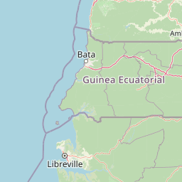
Map view of Altos de Nsork National Park

Use this park location map to pinpoint Altos de Nsork National Park in Equatorial Guinea, understand its exact geographic position, and read its mapped placement within the surrounding landscape more clearly.

Pigeon | © OpenStreetMap contributors

Location context for Altos de Nsork National Park

Continental Region
Park atlas

Compare regional park geography and trace additional protected landscapes within Equatorial Guinea and the broader Central African forest belt

Discover Other National Parks and Protected Areas Near Altos de Nsork National Park
Browse other national parks and protected areas across Equatorial Guinea and the Central African forest belt, tracing the regional spread of conservation landscapes. Compare diverse ecosystems, wildlife habitats, and protected area designations to understand the broader Central African conservation landscape and its geographic context.
National parkWoleu-Ntem Province

Crystal Mountains National Park: National Park Protected Area and Geographic Context in Woleu-Ntem Province

Explore its mapped boundaries and regional landscape.

Crystal Mountains National Park is a designated national park offering critical insights into its protected landscape and geographic setting. Users can explore the mapped boundaries of this protected area, understand its regional terrain, and gain context within Woleu-Ntem Province through structured geographic data. This page provides the foundational atlas information for comprehending the park's conservation significance and natural features.

Area
1,200 km²
Established
2002
IUCN
II
Relief
Mountain
National parkEquatorial Guinea

Monte Alén National Park National Park: Mapped Protected Landscape in Equatorial Guinea

Explore regional geography and park boundaries.

Monte Alén National Park, a designated national park in Equatorial Guinea, offers a unique focal point for understanding protected landscapes. This entry provides detailed geographic context, highlighting the park's mapped boundaries and its significance within the atlas of Central African natural terrain. Investigate the terrain and regional setting of Monte Alén National Park for structured geographic discovery.

Area
2,000 km²
Established
1990
IUCN
II
Relief
Mountain
National parkCameroon

Campo Ma'an National Park: Essential Protected Landscape in Cameroon's Atlantic Biafran Forest

Mapped evergreen canopy and vital great ape habitat in a key conservation area.

Campo Ma'an National Park is a crucial protected area in Cameroon, spanning 2,680 square kilometers of dense Atlantic Biafran forest. Established for environmental compensation, it safeguards critical habitat for western lowland gorillas and central chimpanzees, alongside forest elephants and diverse birdlife. The park's landscape is defined by a persistent evergreen canopy ecosystem, offering a unique context for understanding Central African rainforest geography and protected land status.

Area
2,680 km²
Established
2000
IUCN
II
Climate
Tropical
Watercolor painting of a landscape with grassy areas, a lake, and distant hills under a light sky
National parkGabon

Lopé National Park: Gabon's Protected Landscape and National Park Geography

Explore mapped boundaries and natural terrain in Central Africa.

Delve into Lopé National Park, a designated national park situated in Gabon. This protected area serves as a crucial point for understanding the nation's geography and the distribution of its conservation landscapes. As an entry in the MoriAtlas, it offers a detailed view of its mapped territory and its contribution to the broader regional context of Central Africa, emphasizing its role in protected area atlas exploration.

Area
4,910 km²
Established
2002
IUCN
II
Relief
Mixed relief
National parkGabon

Minkébé National Park: Protected Area and Geographic Context in Gabon

Explore the mapped terrain and protected landscape of this national park.

Gain a structured understanding of Minkébé National Park, a designated national park situated in Gabon. This destination focuses on the park's protected landscape, its distinct mapped boundaries, and its contribution to the regional geography of Central Africa. Examine how its protected status shapes the natural terrain and offers a unique angle for geographic discovery.

Area
7,570 km²
Established
2002
IUCN
II
Relief
Upland
National parkGabon

Pongara National Park: Protected Landscape and Geographic Exploration in Gabon

Mapped boundaries and regional natural context.

Pongara National Park is a designated national park within Gabon, offering a unique opportunity for structured exploration of protected lands. Users can investigate its specific geographic setting, understand its mapped boundaries, and appreciate its place within the regional landscape context. This entry provides a factual foundation for understanding the park's identity as a protected natural area and its contribution to Gabon's geography.

Area
929 km²
Established
2002
IUCN
II
Relief
Lowland
National parkGabon

Ivindo National Park: A Protected Rainforest Landscape in Gabon

Explore its waterfalls, diverse ecosystems, and mapped geographic context.

Ivindo National Park represents a significant protected landscape within Gabon, spanning a vast area of intact tropical rainforest. Recognized as a UNESCO World Heritage Site, the park is defined by the Ivindo River and its dramatic waterfalls, including the famous Kongou and Mingouli Falls. Its geography includes mountainous terrain and vital riverine ecosystems, supporting critical populations of forest elephants and great apes. This page offers a gateway to understanding the park's protected status, its unique natural features, and its role in the broader geography of Central Africa.

Area
3,000 km²
Established
2002
IUCN
II
Relief
Mixed relief
National parkGabon

Waka National Park: A Mapped Protected Landscape in Gabon's Geography

Explore the natural terrain and park boundaries of this national park.

Waka National Park in Gabon represents a vital protected landscape for geographic exploration. This dedicated detail page offers insight into the park's specific mapped area and its place within the country's broader natural terrain. Understand its context as a national park, contributing to the atlas of protected areas in Central Africa. Discover the geographic identity of this significant natural reserve.

Area
1,060 km²
Established
2002
IUCN
II
Relief
Mountain

Common questions about visiting, size, designation, and location context for Altos de Nsork National Park

Altos de Nsork National Park FAQs for park facts, access, geography, and protected area context
Find quick answers about Altos de Nsork National Park, including protected-area facts, park geography, trail and visitor context, and how the park fits into its surrounding country and regional landscape.
MoriAtlas Explorer

Continue Your Protected Areas Search Across the Global Atlas

Deepen your exploration by continuing the structured search for national parks and protected areas worldwide. Utilize the comprehensive filtering capabilities to compare different conservation landscapes and refine your understanding of global park geography. Discover more about the distribution and characteristics of protected natural areas.

Global natural geography