Mori Atlas logo
National parkAmboró National Park

Detailed geographic context and protected area boundaries for atlas exploration.

Amboró National Park: A Mapped Protected Landscape in Bolivia's Santa Cruz Department

(Parque Nacional Amboró)

Amboró National Park stands as a significant protected national park within the Santa Cruz Department of Bolivia, offering a rich geographic identity for dedicated exploration. This detailed profile focuses on its mapped boundaries and the surrounding natural landscape, providing essential context for users interested in atlas-style discovery and understanding protected area distributions. Delve into the specific geography that defines Amboró National Park and its importance as a conservation landscape within its regional setting.

Cloud forestsYungasBiodiversity hotspotAndean ecosystemsBirdwatchingWetland ecosystems

Amboró National Park

National park

Park overview

Structured park overview, official facts, and landscape profile for Amboró National Park

Amboró National Park park facts, protected area profile, and essential visitor context
Review the core facts for Amboró National Park, including designation, size, terrain, visitor scale, habitats, and operating context in one park-focused overview.

About Amboró National Park

Amboró National Park represents one of the most significant conservation achievements in Bolivia, protecting a remarkable concentration of biodiversity at the biogeographic intersection of several major South American ecosystems. The park lies within the Central Andes bioregion and encompasses portions of five distinct ecoregions that would normally be separated by vast distances, creating what amounts to a compressed biodiversity snapshot where tropical, subtropical, and cloud forest environments exist in close proximity. The western portion of the park reaches elevations of 3,338 meters in an area called Siberia, while the lower elevations descend to 300 meters, creating dramatic ecological zonation within a relatively short geographic distance. The park's highly dissected topography, combined with widely varying climatic regimes accompanying sharp elevation changes, partitions biodiversity into distinct ecological niches. Vegetation types within the park include lowland forests, montane forests, yungas, cloud forests, subpáramo, various scrublands, pampas, cactus forests, palm forests, and forests dominated by treeferns, with ecotones often sharply delineated by aspect and elevation. Access to the park requires a guide by law, and the area is bordered to the north and south by roads connecting Cochabamba and Santa Cruz, with the southern road having deteriorated to gravel and dirt since the opening of the northern route in the 1980s.

Quick facts and research context for Amboró National Park

Amboró National Park spans 4,425 km² in central Bolivia's Santa Cruz Department, protecting parts of five distinct ecoregions at the convergence of the Amazon basin and the Andes mountain range. Elevation ranges from 300 meters to 3,338 meters in the western Siberia area, with most of the park between 1,000 and 2,000 meters. Annual rainfall varies between 1,400 and 4,000 millimeters. The park hosts over 912 bird species representing more than 60% of Bolivia's total avifauna, 177 mammal species including the spectacled bear and jaguar, 173 amphibian species, 135 reptile species, and approximately 109 fish species. The area requires a guide for entry and is bordered by roads connecting Cochabamba and Santa Cruz cities.

Park context

Deeper park guide and search-rich context for Amboró National Park

Amboró National Park history, landscape, wildlife, and travel context
Explore Amboró National Park through its history, landscape character, ecosystems, wildlife, conservation priorities, cultural context, and seasonal travel timing in a structured park guide built for atlas discovery and search intent.

Why Amboró National Park stands out

Amboró National Park is best known for its extraordinary botanical richness, containing around 3,000 documented plant species within a relatively modest area, making it one of the most botanically diverse protected areas on Earth. The park is famous for its Yungas cloud forests and the dramatic transitions between ecoregions that occur across its steep topographic gradients. It serves as a critical refuge for the spectacled bear, South America's only bear species, as well as for the southern helmeted curassow and military macaw, two of the region's most emblematic bird species. The park's position at the biological crossroads where Amazonian, Andean, and Chaco ecosystems meet creates exceptional habitat heterogeneity and species diversity.

Amboró National Park history and protected-area timeline

Amboró National Park was initially created in 1973 under the name Reserva de Vida Silvestre German Busch, establishing the first formal protection for this ecologically significant region. In 1984, with significant contributions from native biologist Noel Kempff, British zoologist Robin Clark, and other conservation advocates, the park was redesignated as a national park protecting approximately 1,800 km². The park underwent substantial expansion in 1991, growing to 6,376 km², though this expansion occurred without prior consultation of local populations and disregarded legitimate private property rights, triggering significant protests and resistance from surrounding communities. This controversy necessitated the establishment of two different management categories, demarcated by a so-called Red Line trail marking the boundary between the strict National Park zone and the Integrated Management Natural Zone (IMNA), effectively creating a Multiple Use Zone for surrounding communities. In 1995, following boundary adjustments, the park was reduced to its current size of 4,425 km², with 442,500 hectares designated as national park and 195,100 hectares as IMNA. Management responsibility transitioned from the Decentralized Unit of the Santa Cruz Forest Development Center in 1989 to the Fundación Amigos de la Naturaleza (FAN) with support from The Nature Conservancy's Parks in Peril program, and finally to direct government administration by SERNAP in 1995.

Amboró National Park landscape and geographic character

The landscape of Amboró National Park is defined by dramatic topographic variation and ecological transition, where the eastern cordillera of the Andes bends westward at a critical biogeographic junction. The park's terrain is highly dissected, with elevation changes of over 3,000 meters occurring across relatively short horizontal distances, creating a landscape of extraordinary vertical relief. The westernmost area, known as Siberia, reaches the park's highest point at 3,338 meters, while the lower elevations in the eastern portions descend to approximately 300 meters. Annual rainfall ranges from 1,400 millimeters in lower areas to 4,000 millimeters in higher cloud forest zones. The park's location at the Elbow of the Andes places it at the intersection of major geographic and climatic regimes, where moisture-laden air from the Amazon encounters the barrier of the Andes, creating the conditions for cloud forest formation at higher elevations. The combination of steep terrain, varying aspect, and climatic gradients produces highly heterogeneous landscapes that can change dramatically over short distances, making travel through the park a dynamic experience of ecological transition.

Amboró National Park ecosystems, habitats, and plant life

The ecological character of Amboró National Park is defined by its extraordinary biodiversity and the complex layering of distinct ecosystems within a relatively compact area. The park lies at the confluence of several major floristic regions: the tropical Amazon lowlands and pampas to the north and southeast, the subantarctic high Andes and altiplano to the west and southwest, the subtropical Tucumano-Boliviano forests to the south, and the semiarid inter-Andean valleys with wet-tropical yungas forests on the eastern slopes of the central Bolivian Andes. This convergence of floristic regions, combined with the park's steep topographic variation and climatic gradients, creates exceptional vegetational diversity including lowland forests, montane forests, yungas, cloud forest, subpáramo, montane and non-montane scrublands, pampas, cactus forests, palm forests, forests of treeferns, bromeliad-laden cliffs, and epilithic subalpine plant communities. The approximately 3,000 documented plant species include bigleaf mahogany, mountain pine, black walnut, various endemic orchids, açaí palms, and extensive patches of giant tree ferns in the cloud-enveloped forests. Many portions of the park remain essentially unstudied due to difficult terrain and lack of infrastructure, suggesting that the current species counts represent significant underestimates of the park's true biodiversity.

Amboró National Park wildlife and species highlights

Amboró National Park supports extraordinary wildlife diversity, with 177 documented mammalian species including 43 bat species, representing one of the most significant mammalian communities in Bolivia. The park provides crucial habitat for the spectacled bear (locally known as jucumari), South America's only bear species, as well as for the jaguar, puma, and ocelot. The giant anteater also occurs within the park's boundaries. The bird fauna exceeds 912 species, representing more than 60% of Bolivia's total avifauna, making the park a globally significant area for bird conservation. Notable bird species include the southern helmeted curassow and the military macaw, two of the most emblematic birds of the region. Amphibian diversity is exceptionally high, with 173 species documented including 50 species of toads, while 135 reptile species have been recorded. Fish diversity includes 109 species identified within the IMNA alone, with species composition depending strongly on altitude, with larger species like sábalo, barred surubim, and pacú restricted to alluvial plains below 700 meters. The park presents high levels of endemism across multiple taxa.

Amboró National Park conservation status and protection priorities

Amboró National Park represents a critical conservation priority due to its extraordinary biodiversity concentration within a relatively limited area, positioning it as one of the most botanically rich protected areas in the world. The park protects portions of five distinct ecoregions that would typically require traveling vast distances to encounter, creating an exceptional conservation value disproportionate to its area. The high rates of endemism throughout the tropical Andes suggest that many undocumented plant species awaiting discovery in the park's remote regions will likely be Amboró endemics unknown to science. However, the park faces ongoing conservation challenges including pressure from human settlements, illegal hunting, mining activity, and deforestation, despite its protected status. The establishment of the Integrated Management Natural Zone (IMNA) as a Multiple Use Zone adjacent to the strict national park reflects attempts to balance conservation objectives with the legitimate land-use needs of local communities, though boundary conflicts have required constant redefinition. The park's management falls under the Servicio Nacional de Áreas Protegidas (SERNAP), Bolivia's national protected area authority.

Amboró National Park cultural meaning and human context

The Amboró region has been inhabited by human communities for centuries, with the northern area containing colonial settlements originating from the highland regions, while the southern boundary zone is inhabited by peasants from the valley regions of Santa Cruz Department. Toward the east, Guaraya communities have established settlements in the surrounding areas. The establishment of the national park created complex interactions with these local populations, particularly following the 1991 expansion that disregarded private property rights and triggered significant community resistance. This conflict necessitated the creation of the Integrated Management Natural Zone (IMNA), a Multiple Use Zone that allows sustainable resource use by local communities while preserving core conservation areas. The towns surrounding the park, including Samaipata, Comarapa, and Buena Vista, maintain cultural connections to the protected area and serve as access points for visitors. These communities represent the human dimension of the park's management, where conservation success depends on balancing ecological protection with the livelihoods and rights of indigenous and local populations.

Top sights and standout views in Amboró National Park

Amboró National Park stands out as a globally significant biodiversity hotspot where the convergence of Amazonian, Andean, and Chaco ecosystems creates extraordinary species richness within a compressed geographic area. The park's approximately 3,000 plant species make it more botanically diverse than areas many times its size, including the entire Hawaiian archipelago and British Isles combined. The Yungas cloud forests represent some of the finest expressions of this ecosystem type, while the dramatic elevation gradient from 300 to 3,338 meters creates habitat heterogeneity rarely found elsewhere. The bird checklist of over 912 species represents more than 60% of Bolivia's total avifauna, with the southern helmeted curassow and military macaw serving as flagship species. The spectacled bear, South America's only bear species, finds refuge within the park's diverse habitats. The complex management history, including the establishment of the Red Line boundary between strict protection and community-managed zones, reflects the challenges of conserving this biological treasure while respecting local community rights and livelihoods.

Best time to visit Amboró National Park

The optimal time to visit Amboró National Park depends on the specific experiences sought, though the park can be explored year-round given its maintained access points and guide requirements. The wet season from November to April brings higher rainfall, particularly at higher elevations in the cloud forest and Yungas zones, creating lush vegetation and full waterfalls, though some trails may become more difficult to traverse. The dry season from May to October offers clearer conditions and more accessible trail networks, with reduced precipitation making exploration easier, though cloud forest visibility may be less dramatic. The shoulder seasons of April through June and September through November may offer the best balance of conditions, with moderate rainfall and comfortable temperatures across the elevation gradient. Regardless of season, visitors should be prepared for the rapid microclimate changes that occur across the park's dramatic elevation range, where conditions at 3,338 meters in Siberia can differ substantially from the lower elevation forests.
Park location guide

Geography guide, regional context, and park location map for Amboró National Park

Amboró National Park park geography, regions, and map view in Bolivia
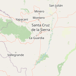
Understand where Amboró National Park sits in Bolivia through a broader geographic reading of the surrounding landscape, nearby location context, and its mapped position within the national park landscape.

How Amboró National Park fits into Bolivia

Bolivia, officially the Plurinational State of Bolivia, is a landlocked country in central South America. It features diverse geography including the Andean mountain range, Amazonian plains, Gran Chaco, and the Pantanal wetland. The country has a population of approximately 11.4 million and is administratively divided into nine departments, with La Paz as the seat of government and Sucre as the constitutional capital.

Wider geography shaping Amboró National Park in Bolivia

Bolivia is located in central South America, bordered by Brazil to the north and east, Paraguay to the southeast, Argentina to the south, Chile to the southwest, and Peru to the west. The country is divided between a western Andean region and tropical lowlands to the east and north. It includes the Amazonian plain, Gran Chaco, temperate valleys, the high-altitude Altiplano plateau, and part of the Pantanal wetland along its eastern border.

Map view of Amboró National Park

Use this park location map to pinpoint Amboró National Park in Bolivia, understand its exact geographic position, and read its mapped placement within the surrounding landscape more clearly.

Pigeon | © OpenStreetMap contributors

Location context for Amboró National Park

Santa Cruz Department
Park atlas

Compare the unique Andean and Amazonian protected landscapes in Bolivia and beyond.

Discover Nearby National Parks and Protected Areas Around Amboró National Park
Browse a curated list of national parks and protected areas geographically close to Amboró National Park, allowing for comparative exploration of diverse Andean and Amazonian ecosystems. Trace interconnected protected landscapes and observe how conservation efforts unfold across Bolivia's remarkable geographic transitions and varied natural environments.
National parkCochabamba Department

Carrasco National Park: National Park Status and Protected Landscape Geography

Explore mapped boundaries within Cochabamba Department.

Carrasco National Park, situated within the Cochabamba Department, represents a critical national park entity. This focus provides users with an atlas-centric view of its protected landscape, detailing its geographic significance and mapped features. Understand the park's terrain and regional context, offering a clear perspective on its conservation value and mapped presence.

Area
6,226 km²
Established
1991
IUCN
II
Relief
Mountain
National parkChuquisaca Department

Iñao National Park and Integrated Management Natural Area: Bolivia National Park and Protected Landscape

Explore the Serranía del Iñao's geography and conservation role.

Iñao National Park and Integrated Management Natural Area is a protected territory located within Chuquisaca Department, Bolivia, centered on the prominent Serranía del Iñao mountain range. This page offers detailed geographic context and an atlas perspective on the park's landscape, its role as a national park, and its contribution to regional conservation efforts in the Andean foothills.

Area
2,630.9 km²
Established
2004
IUCN
II
Scope
Terrestrial
National parkPotosí Department

Torotoro National Park: Paleontology and Karst Landscape Exploration in Bolivia

Discover prehistoric footprints within dramatic Andean canyon geography.

Torotoro National Park in the Potosí Department is a protected area distinguished by its rich paleontological significance and unique semi-arid mountain terrain. Featuring dramatic canyon systems plunging hundreds of meters deep, the park showcases thousands of Cretaceous dinosaur footprints alongside its complex karst topography, complete with caves and sinkholes, offering a profound glimpse into both ancient life and sculpted natural geography.

Area
165 km²
Established
1989
IUCN
II
Relief
Mountain
Watercolor illustration showing a mountain range with green fields, a river, and soft pastel colors
National parkCochabamba Department

Tunari National Park: Protected Landscape Atlas and Geographic Context

Mapped boundaries within Cochabamba Department's geography.

Tunari National Park represents a vital protected landscape within the Cochabamba Department of Bolivia. This page offers an atlas-centric exploration of the park's geographic boundaries, its relationship to the surrounding regional terrain, and its significance as a national park. Delve into the mapped context of Tunari National Park to understand its protected area status and its contribution to Bolivia's diverse geography.

Area
3,090 km²
Established
1992
IUCN
II
Relief
Mountain
National parkBolivia

Isiboro Sécure National Park and Indigenous Territory: Bolivian Protected National Park Atlas

Mapped protected boundaries and regional landscape context.

Investigate Isiboro Sécure National Park and Indigenous Territory as a key protected national park within Bolivia's expansive geography. This resource offers detailed views of its mapped natural landscape and its regional significance as a protected area. Understand the park's geographic attributes and its contribution to the country's conservation atlas through structured map-based exploration.

Area
13,721.8 km²
Established
1965
IUCN
II
Relief
Mixed relief
National parkBolivia

Kaa-Iya del Gran Chaco National Park and Integrated Management Natural Area: Bolivia's National Park and Protected Landscape

Explore the mapped geography and regional natural landscape.

Kaa-Iya del Gran Chaco National Park and Integrated Management Natural Area stands as a crucial component of Bolivia's protected lands, offering a distinct entry point for exploring its natural geography. This page details the park's status as a national park and integrated management natural area, providing context for its mapped boundaries and its role within the country's diverse landscapes. Engage with structured information designed to illuminate the park's geographic setting and its significance for atlas-style exploration and understanding of Bolivia's protected areas.

Area
34,411.1 km²
Established
1995
Relief
Upland
Climate
Subtropical
Protected areaGran Chaco Province

Aguaragüe National Park and Integrated Management Natural Area: Bolivia's Easternmost Sub-Andean Protected Landscape

Explore its mapped mountain geography and ecological diversity.

Aguaragüe National Park and Integrated Management Natural Area is a crucial protected area in Bolivia's Gran Chaco Province, defined by the Serranía del Aguaragüe mountain range. This landscape offers a unique opportunity to explore a geographic transition zone where Southern Andean Yungas montane forests converge with Dry Chaco ecosystems. The park's protected boundaries encompass a rugged mountain backbone rising from the lowlands, representing a vital segment of Bolivia's Sub-Andean geography and protected natural areas.

Area
1,083.07 km²
Established
2000
IUCN
II
Relief
Mountain
National parkLa Paz Department

Cotapata National Park and Integrated Management Natural Area: A Protected Landscape in La Paz Department, Bolivia

Explore its mapped boundaries and regional geographic context.

Delve into the protected landscape identity of Cotapata National Park and Integrated Management Natural Area, situated within the La Paz Department of Bolivia. This entry provides essential geographic context, focusing on its mapped protected area status and its contribution to the regional landscape, ideal for atlas-based exploration and understanding Bolivia's conservation network.

Area
600 km²
Established
1993
IUCN
II
Scope
Terrestrial

Common questions about visiting, size, designation, and location context for Amboró National Park

Amboró National Park FAQs for park facts, access, geography, and protected area context
Find quick answers about Amboró National Park, including protected-area facts, park geography, trail and visitor context, and how the park fits into its surrounding country and regional landscape.
MoriAtlas Explorer

Continue Your Protected Areas Search Across the Global Atlas

Deepen your exploration by continuing the structured search for national parks and protected areas worldwide. Utilize the comprehensive filtering capabilities to compare different conservation landscapes and refine your understanding of global park geography. Discover more about the distribution and characteristics of protected natural areas.

Global natural geography