

Mori Atlas logo
Marine protected areaApollo Marine Park

Mapping deep sea valleys and maritime heritage sites within an Australian marine protected area

Apollo Marine Park: Analyzing the Submerged Geomorphology of the Victorian Bass Strait Coast

Apollo Marine Park preserves a profound submarine landscape beneath the waters of Bass Strait, off the southern coast of Victoria. This protected area centers on the Otway Depression, an ancient submerged valley that once drained the Bassian Plain before rising sea levels inundated the region at the end of the last ice age. Beyond its geological significance, the seafloor contains historical markers, including the wreck of the MS City of Rayville, linking modern conservation with maritime history.

Bass Straitmarine parksubmarine canyonOtway DepressionCommonwealth marine reserveMultiple Use zone

Apollo Marine Park

Marine protected area

Park overview

Structured park overview, official facts, and landscape profile for Apollo Marine Park

Apollo Marine Park park facts, protected area profile, and essential visitor context

Review the core facts for Apollo Marine Park, including designation, size, terrain, visitor scale, habitats, and operating context in one park-focused overview.

About Apollo Marine Park

Apollo Marine Park lies in the southern waters of Australia, occupying a significant section of Bass Strait between the Victorian mainland and King Island at the north-west tip of Tasmania. Although not far from popular surf and tourism destinations such as Apollo Bay, the marine park is entirely offshore, covering seabed and water column rather than any land area. With nearly 1,200 square kilometres of designated waters, it represents a meaningful segment of the broader Australian Marine Parks system in the country's south-east.

Geologically, the reserve is defined by what lies beneath the surface. The Otway Depression is a submarine valley that drops roughly 100 metres below the surrounding Bass Basin floor, creating a connecting corridor between the enclosed basin and the deeper ocean to the south-west. During the last ice age, when sea levels were far lower, the area that is now Bass Strait was a wide plain crossed by rivers and drained by lakes, including the lost Bass Lake. The Otway Depression acted as the major outlet for this freshwater system, and the channels that once carried that flow still shape the seabed today. As sea levels rose at the end of the glacial period, the valley was drowned, leaving a preserved fossil river system underwater.

This combination of deep submarine topography and relict terrestrial drainage makes Apollo Marine Park a rare example of a marine reserve whose conservation value is strongly tied to its geological inheritance. The reserve also sits within a productive and ecologically important region of Bass Strait, where nutrient-rich waters support diverse marine life and where islands such as King Island mark the western boundary of the network. As a Multiple Use zone, the park operates under management arrangements that allow recreational activities and certain forms of commercial use while still protecting the integrity of the underlying marine environment.

Beyond its natural values, the marine park has tangible human history. Near Cape Otway on its northern edge lie the remains of the MS City of Rayville, the first American merchant vessel lost during the Second World War. The combination of submarine geology, ecological significance and wartime heritage gives Apollo Marine Park a distinct and layered identity within Australia's network of marine protected areas.

Quick facts and research context for Apollo Marine Park

Apollo Marine Park is a Commonwealth marine park in Bass Strait, situated off Victoria's coastline between Cape Otway and the approaches to King Island. It was established on 31 August 2007 as the Apollo Commonwealth Marine Reserve and later renamed to its current title within the Australian Marine Parks framework.

The reserve covers about 1,184 square kilometres of ocean and seabed and is administered by Parks Australia as part of the South-east Marine Parks Network. The entire area is zoned as Multiple Use under IUCN Category VI, allowing regulated recreational and commercial activity. The park's most distinctive physical feature is the Otway Depression, a 100-metre-deep submerged valley that once drained the ice-age Bass Lake.

Protection and recognition

Examine the official protection scope, management framework, and recognized status of Apollo Marine Park.

Apollo Marine Park Protection Status and Conservation Governance Records

Marine protection status and management scope for Apollo Marine Park provide a clear baseline of administrative records. Documented conservation designations outline the governance framework established for this protected natural area.

Protection details

Protection scope
Marine
Transboundary protection
No
Park context

Deeper park guide and search-rich context for Apollo Marine Park

Apollo Marine Park history, landscape, wildlife, and travel context

Explore Apollo Marine Park through its history, landscape character, ecosystems, wildlife, conservation priorities, cultural context, and seasonal travel timing in a structured park guide built for atlas discovery and search intent.

Why Apollo Marine Park stands out

Apollo Marine Park is best known for the Otway Depression, a submarine canyon roughly 100 metres deep that connects the Bass Basin to the open ocean through a valley carved when Bass Strait was dry land. This drowned landscape contains the relict drainage channels of the ancient Bass Lake and mainland rivers that existed during the last glacial period, offering an unusually clear underwater record of how sea levels reshaped southeastern Australia. The park is also recognised for its overall role within the South-east Marine Parks Network as a Multiple Use marine reserve that balances conservation of Bass Strait seabed habitats with regulated fishing and other marine activities. Its location near Cape Otway places it above the wreck of the MS City of Rayville, adding a wartime heritage dimension to the park's identity.

Apollo Marine Park history and protected-area timeline

Apollo Marine Park was formally established on 31 August 2007 as the Apollo Commonwealth Marine Reserve, one of the new generation of Commonwealth marine reserves declared by the Australian Government to improve protection of offshore waters around the continent. Its creation reflected a growing recognition of the ecological and geological importance of Bass Strait, a stretch of water historically more associated with shipping and commercial fishing than with formal conservation.

The reserve was later incorporated into the broader Australian Marine Parks framework under Parks Australia, becoming part of the South-east Marine Parks Network. As part of this restructuring, the reserve was renamed from Apollo Commonwealth Marine Reserve to Apollo Marine Park, aligning it with the naming conventions used across the national system. The entire park remains classified as a Multiple Use Zone under IUCN Category VI, meaning it continues to accommodate regulated recreational and commercial activities alongside its conservation role.

The deeper history of the area, long before formal protection, is written into the seabed itself. During the last glacial period, when Bass Strait was above sea level, the Otway Depression served as the main outlet for the ancient Bass Lake and its tributary river systems. The drowned channels preserved beneath the park are effectively a natural archive of that lost landscape. More recently, in the twentieth century, the waters above the park became the final resting place of the MS City of Rayville, making this stretch of Bass Strait a site where prehistoric geology and modern maritime history both leave their marks.

Apollo Marine Park landscape and geographic character

The landscape of Apollo Marine Park is entirely submerged, defined by the underwater topography of Bass Strait rather than by any visible landforms. The seabed here includes the Otway Depression, a clearly defined submarine valley that descends around 100 metres beneath the level of the surrounding Bass Basin. This depression runs from the basin outward toward the open southern ocean and forms the most distinctive physical feature of the reserve.

What makes this undersea landscape especially significant is its origin. The Otway Depression was not shaped by present-day marine processes alone; it is a drowned river valley. During the last ice age, when sea levels were far lower and Bass Strait was a partly dry plain, this valley carried water from the inland Bass Lake and its connected river systems toward the open ocean. When the ice age ended and sea levels rose, the valley was inundated, leaving behind a fossil drainage system etched into the seafloor.

Above the seabed, the waters of Bass Strait themselves complete the park's landscape. The region is known for its often dynamic sea conditions, nutrient-rich currents and the way open ocean waters meet more enclosed basin waters. Together these characteristics create a seascape whose geological foundations and oceanographic setting together define the identity of Apollo Marine Park.

Apollo Marine Park ecosystems, habitats, and plant life

Although the marine park is best known for its geology, its ecological context is also central to its identity. Apollo Marine Park occupies a productive zone of Bass Strait where waters from the enclosed basin interact with the cooler, more open southern ocean. This mixing supports nutrient availability that feeds a diverse community of marine life, including fish species, invertebrates and the seabirds that depend on Bass Strait's waters.

The conservation of seabed habitats in this part of Bass Strait is a key ecological consideration. The Otway Depression and its surrounding seafloor provide varied substrates and depth profiles, which are important for different species patterns and for the overall health of the regional marine environment. By protecting a substantial area of offshore waters under a Multiple Use framework, the park contributes to broader habitat connectivity across the South-east Marine Parks Network, helping to maintain ecological processes at a regional scale.

Apollo Marine Park wildlife and species highlights

Apollo Marine Park's wildlife significance is closely tied to its position in one of the most biologically productive stretches of Bass Strait. The cool, nutrient-rich waters here support populations of fish and other marine animals typical of the Bass Strait region, as well as the seabirds that range across these waters from nearby Victorian and Tasmanian coastlines and from King Island.

Because the park is entirely offshore, most of its wildlife value lies beneath the waves and across the sea surface rather than on land. The diverse seabed environments shaped by the Otway Depression and the wider Bass Basin offer habitat variety that influences local species distribution. The reserve's role as part of the South-east Marine Parks Network also means that wildlife patterns within Apollo Marine Park are best understood in connection with neighbouring marine protected areas rather than in isolation.

Apollo Marine Park conservation status and protection priorities

Apollo Marine Park's conservation significance rests on the protection it provides for a substantial area of Bass Strait seabed and water, including the Otway Depression and its unique submerged valley system. Because this valley preserves a relict drainage of the last ice age, it has value as a geological reference site as well as a marine habitat, giving the park a conservation rationale that spans both ecological and earth-science considerations.

The park is classified under IUCN Category VI and is wholly zoned for Multiple Use, reflecting a management approach that seeks to preserve the marine environment while allowing regulated human activities such as recreational fishing and, with approval, certain commercial uses. Managed by Parks Australia as part of the South-east Marine Parks Network, Apollo Marine Park contributes to the broader goal of building a connected network of marine reserves around southern Australia, supporting long-term resilience of the Bass Strait marine environment and helping to safeguard the region's natural and cultural heritage for the future.

Apollo Marine Park cultural meaning and human context

The cultural context of Apollo Marine Park is largely shaped by its proximity to the Victorian coast near Apollo Bay and Cape Otway, and to King Island at the north-west of Tasmania. These shorelines have histories of Indigenous connection, maritime activity, fishing communities and, in more recent centuries, European settlement that depended heavily on Bass Strait for trade, transport and livelihood.

The wartime heritage associated with the park adds another cultural layer. The wreck of the MS City of Rayville, the first American vessel sunk during World War II, sits within the marine park's boundaries near Cape Otway, placing Apollo Marine Park at the intersection of Australia's maritime wartime history and its natural marine heritage.

Top sights and standout views in Apollo Marine Park

The most powerful highlight of Apollo Marine Park is the Otway Depression itself, a 100-metre-deep submarine valley that once served as the main outlet for the ice-age Bass Lake. Its preserved river channels make the park an exceptional underwater archive of how sea level rise reshaped Bass Strait at the end of the last glacial period.

Equally distinctive is the park's dual natural and historical character, with the seabed geology of Bass Strait complemented by the wartime wreck of the MS City of Rayville near Cape Otway. Together these features make Apollo Marine Park a marine reserve where deep-time geology and twentieth-century maritime history coexist within a single offshore boundary.

Best time to visit Apollo Marine Park

Because Apollo Marine Park is an entirely offshore reserve with no visitor facilities of its own, the rhythm of any nearby visit is shaped by the broader conditions of Bass Strait rather than by the park's seasonal opening dates. Bass Strait experiences relatively mild but changeable conditions through the Australian summer months, when calmer weather and longer daylight typically make offshore travel and coastal exploration around Apollo Bay and Cape Otway more approachable.

In the cooler months, weather windows for going out on the water tend to be shorter and swells can be stronger, though the same waters that make travel more challenging also support active marine life and seasonal wildlife patterns in the wider region. Any decision to visit the area should remain flexible in step with Bass Strait's notoriously variable conditions, regardless of season.
Monthly climate preview

Examine long-term representative temperature and precipitation averages by month for Victoria

Apollo Marine Park Climate Normals and Annual Temperature Patterns

Apollo Marine Park records measured monthly temperature variations and precipitation rhythms from historical satellite climatology points. Detailed monthly climate normals provide full historical data for analyzing temperature ranges and rainfall distributions across the year.
Annual mean14 °C
12 °C17 °C
Jan17°
Feb17°
Mar17°
Apr15°
May14°
Jun13°
Jul12°
Aug12°
Sep12°
Oct13°
Nov14°
Dec15°
Warmest month
February

17.3 °C

Coolest month
August

11.8 °C

Wettest month
August

3.1 mm/day

Driest month
February

1.5 mm/day

Park location guide

Geography guide, regional context, and park location map for Apollo Marine Park

Apollo Marine Park park geography, regions, and map view in Australia

Understand where Apollo Marine Park sits in Australia through a broader geographic reading of the surrounding landscape, nearby location context, and its mapped position within the national park landscape.

How Apollo Marine Park fits into Australia

Australia is a constitutional monarchy and federal parliamentary democracy comprising six states and ten territories. With a population of nearly 28 million, it is one of the world's most urbanised countries, with most people concentrated on the eastern seaboard. The country has a high Human Development Index and is known for its cultural diversity, ancient Aboriginal heritage, and unique wildlife.

Wider geography shaping Apollo Marine Park in Australia

Australia occupies the entire Australian continent, the island of Tasmania, and numerous smaller islands. It is the world's flattest and driest inhabited continent, featuring vast deserts in the interior (the Outback), tropical rainforests along the eastern coast, and a coastline bordering the Indian and Pacific Oceans.

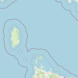
Map view of Apollo Marine Park

Use this park location map to pinpoint Apollo Marine Park in Australia, understand its exact geographic position, and read its mapped placement within the surrounding landscape more clearly.

Pigeon | © OpenStreetMap contributors

Location context for Apollo Marine Park

Victoria
Natural feature types

Explore the Named Natural Features and Geography of Apollo Marine Park

Continue your geographic discovery by examining the submarine terrain and geological features of Apollo Marine Park. This structured index allows you to map the underwater landmarks and historical seafloor traces that define the protected landscape within the South-east Marine Parks Network.
Recorded earthquake history

Browse the Historical Earthquake Catalogue for Apollo Marine Park

Investigate recorded seismic events associated with the offshore geography of Apollo Marine Park. This catalogue provides direct access to historical event data, including event dates, magnitudes, and proximity to the submarine landscapes of the Bass Strait protected area.

Apollo Marine Park Earthquake History

Catalogued events

5 events

Strongest magnitude

Magnitude 4.8

Most recent event

Jul 5, 2026

This history includes earthquakes recorded inside the park or within 50 km of its borders

Park atlas

Compare adjacent marine reserves and discover connected coastal landscapes across Bass Strait

Exploring Parks Near Apollo Marine Park And Protected Areas In The Surrounding Region

Visitors exploring Apollo Marine Park can browse adjacent marine reserves and protected areas across Bass Strait to compare submerged topography and regional conservation networks. Expanding the geographic scope reveals broader patterns in offshore geology, marine habitats, and protected landscapes.
National parkAustralia
5.9 km away#1 closest

North

Great Otway National Park: Discover Its Mapped Boundaries and Unique Temperate Rainforest Geography

Explore the diverse terrain and protected landscape of Victoria's coastal ranges.

Great Otway National Park represents a vital protected natural area, distinguished by its dramatic confluence of coastal features and lush inland temperate rainforests. Situated within the Otway Ranges, the park's mapped landscape includes rugged coastlines, V-shaped valleys, and numerous waterfalls that cascade through ancient fern gullies. Understanding the park's geographic setting and protected area status is central to appreciating its ecological significance and its place within the broader Australian conservation landscape. This detailed view allows for in-depth exploration of its unique terrain and protected natural resources.

Area
1,032 km²
Established
2005
IUCN
II
Relief
Mountain
Marine protected areaAustralia
34 km away#2 closest

Northwest

Twelve Apostles Marine National Park: Protected Landscape and Marine Atlas Exploration

Mapping iconic rock stacks and underwater reef geography.

Twelve Apostles Marine National Park, located on Victoria's south coast, is a key marine protected area renowned for its striking limestone rock stacks and the diverse underwater ecosystems they shelter. This park offers a unique opportunity for atlas exploration, detailing the mapped boundaries and the fascinating marine geography from cliff faces to submerged reefs. Understand the protected landscape and its integral role within Australia's coastal conservation network.

Area
75 km²
Established
2002
IUCN
II
Climate
Temperate
National parkAustralia
38 km away#3 closest

Northwest

Port Campbell National Park: Iconic Limestone Cliffs and Coastal Protected Area

Explore the mapped geography of Victoria's dramatic Shipwreck Coast.

Port Campbell National Park, a prominent national park in Victoria, Australia, offers an unparalleled atlas exploration of coastal geology. Its landscape is defined by towering limestone cliffs, iconic offshore rock stacks such as the Twelve Apostles, and numerous natural arches and blowholes sculpted by the Southern Ocean. This protected area provides critical geographic context for the Shipwreck Coast's dramatic terrain and serves as a focal point for understanding Australia's dynamic natural heritage.

Area
17.5 km²
Established
1964
IUCN
II
Visitors
2M annual
Marine protected areaTasmania
49 km away#4 closest

Southwest

Zeehan Commonwealth Marine Reserve: Geographic Map and Protected Marine Landscape Overview

Deep-sea habitats and shelf bathymetry off the Tasmanian coast

Spanning from fifty meters to over three thousand meters deep, the Zeehan Commonwealth Marine Reserve represents a massive, bathymetrically diverse protected area in the southern Indian Ocean. This geographic overview highlights the reserve's role in conserving limestone seabed features and deep-sea corridors west of Tasmania, offering a clear perspective on its location and scale within the broader regional marine network.

Area
19,897 km²
Established
2007
IUCN
VI
Relief
Lowland
National parkAustralia
About 74 km away#5 closest

Northeast

Point Addis Marine National Park: Victoria's Protected Coastal Atlas

Mapped marine park and coastal landscape context.

Point Addis Marine National Park is a significant protected marine area situated along the renowned Surf Coast of Victoria, Australia. This park safeguards the coastal waters and shoreline around iconic locations like Bells Beach, preserving vital marine habitats including extensive rocky reefs and kelp forests. Its geography is defined by dramatic sandstone cliffs and the influence of the Southern Ocean, making it a crucial site for understanding temperate marine ecosystems within a popular recreational region. Discover its mapped boundaries and ecological significance for regional geography.

Area
46 km²
Established
2002
IUCN
II
Climate
Temperate
Protected areaVictoria
About 103 km away#6 closest

Northwest

Framlingham Forest Indigenous Protected Area: Geography and Landscape Overview

Aboriginal-owned savanna woodlands in Western Victoria

Framlingham Forest Indigenous Protected Area is an important cultural and ecological site in south-western Victoria. Spanning over 1,100 hectares of stringybark and manna gum savannah, this protected area offers a unique glimpse into the native woodland ecosystems that once defined the Western District plains near the Hopkins River.

Area
11.3 km²
Established
2009
Relief
Lowland
Scope
Terrestrial
National parkAustralia
About 109 km away#7 closest

Northeast

Point Nepean National Park: Protected Coastal Landscape & Geographic Context

Discover the mapped boundaries of this Australian national park.

Point Nepean National Park represents a vital protected landscape situated at the southern extremity of the Mornington Peninsula, Australia. This national park encompasses a rugged headland that forms the critical entrance to Port Phillip Bay, characterized by striking limestone cliff formations and coastal ecosystems. As a site of historical military importance, Point Nepean National Park offers a distinct geographic identity and a unique protected area for atlas-based exploration and understanding its regional context.

IUCN
II
National parkAustralia
109 km away#8 closest

Northeast

Mornington Peninsula National Park: Victoria's Coastal Protected Landscape and Map Atlas

Explore dramatic cliff-top terrain, sandy beaches, and native bushland.

Mornington Peninsula National Park is a protected natural area defined by its spectacular coastal geography in Victoria, Australia. The park features striking cliff-top vistas, extensive sandy beaches, and sculpted dunes that showcase the dynamic forces shaping Australia's coastline. Its mapped boundaries protect a vital landscape including areas like Greens Bush, offering a glimpse into the region's native vegetation and geological formations for those interested in detailed geographic context and protected area exploration.

Area
26.86 km²
Established
1995
IUCN
II
Relief
Mixed relief

Common questions about visiting, size, designation, and location context for Apollo Marine Park

Apollo Marine Park FAQs for park facts, access, geography, and protected area context

Find quick answers about Apollo Marine Park, including protected-area facts, park geography, trail and visitor context, and how the park fits into its surrounding country and regional landscape.
MoriAtlas Explorer

Continue Your Protected Areas Search Across the Global Atlas

Deepen your exploration by continuing the structured search for national parks and protected areas worldwide. Utilize the comprehensive filtering capabilities to compare different conservation landscapes and refine your understanding of global park geography. Discover more about the distribution and characteristics of protected natural areas.

Global natural geography