Mori Atlas logo
National parkAssagny National Park

Discover the mapped boundaries and regional terrain of this protected natural area.

Assagny National Park: Ivory Coast's Protected Landscape and National Park Geography

(Parc national d'Azagny)

Assagny National Park stands as a protected national park within Ivory Coast, offering a unique lens for exploring West African geography and conservation landscapes. This page details its mapped boundaries and the regional natural terrain, providing structured discovery for those interested in the park's specific protected landscape identity and its place within the broader geographic context of the Ivory Coast.

Mangrove ForestsWetland ReserveRamsar SiteImportant Bird AreaIvory Coast National ParkCoastal Ecosystem

Assagny National Park

National park

Park overview

Structured park overview, official facts, and landscape profile for Assagny National Park

Assagny National Park park facts, protected area profile, and essential visitor context
Review the core facts for Assagny National Park, including designation, size, terrain, visitor scale, habitats, and operating context in one park-focused overview.

About Assagny National Park

Assagny National Park represents one of Ivory Coast's significant coastal protected areas, located in the southern portion of the country along the Gulf of Guinea. The park's geographic position between the Bandama River and Ébrié Lagoon places it at the interface of freshwater and brackish water environments, creating a hydrologically complex wetland system. The Asagni Canal, a navigable waterway, traverses the park and connects the river to the lagoon, facilitating the exchange of water and species between these two systems. The surrounding terrain is slightly elevated relative to the park's low-lying basin, which traps water and creates persistent waterlogging throughout much of the year. The park's ecosystem is characterized by three primary habitat types: the dominant mangrove swamps along the water channels and lagoon edges, patches of moist evergreen forest on slightly higher ground, and coastal savanna areas supporting grasslands. This habitat diversity supports a range of wildlife species and creates ecological conditions that are distinct within the West African coastal zone. The park's proximity to Abidjan, approximately 75 kilometers to the east, positions it as a potential destination for ecological tourism and environmental education within Ivory Coast's protected area network.

Quick facts and research context for Assagny National Park

Assagny National Park lies in the southern coastal region of Ivory Coast, positioned between the Bandama River estuary and Ébrié Lagoon. The protected area spans roughly 17,000 hectares and was established in 1981. The landscape consists primarily of mangrove-dominated swamps covering about two-thirds of the park, with remaining areas supporting moist forest and coastal savanna. The climate is perennially wet, and the terrain remains waterlogged for much of the year. The park was recognized as a Ramsar Wetland of international importance in 1996 and is identified by BirdLife International as an Important Bird Area.

Park context

Deeper park guide and search-rich context for Assagny National Park

Assagny National Park history, landscape, wildlife, and travel context
Explore Assagny National Park through its history, landscape character, ecosystems, wildlife, conservation priorities, cultural context, and seasonal travel timing in a structured park guide built for atlas discovery and search intent.

Why Assagny National Park stands out

Assagny National Park is best known for its extensive mangrove swamp ecosystems, which dominate approximately two-thirds of the park's terrain and create a complex tidal wetland environment along the Ivorian coast. The park serves as a critical habitat for wetland birds, particularly herons, egrets, and the peregrine falcon, earning recognition as both a Ramsar Wetland and an Important Bird Area. The protected area also supports populations of African elephants, chimpanzees, and multiple primate species within its forest patches, as well as all three West African crocodile species in its waterways and lagoons. The combination of mangrove forest, freshwater swamp, and coastal savanna creates a layered ecological profile that is relatively rare in West Africa's protected landscape.

Assagny National Park history and protected-area timeline

Assagny National Park was established in January 1981 as part of Ivory Coast's expanding national park system during a period when the country was developing its protected area network to conserve representative ecosystems across different biogeographic zones. The park was subsequently designated as a Ramsar Wetland on February 27, 1996, recognizing its international significance as a coastal wetland habitat. This designation came as part of Ivory Coast's commitment to the Ramsar Convention on wetlands, which the country had joined to acknowledge the ecological importance of its coastal and inland wetland systems. The Ramsar designation specifically highlights the park's value as a habitat for waterbird species and its role in supporting migratory bird populations along the West African coast. Prior to and following establishment, the surrounding region has been subject to agricultural development and human settlement pressure, making the protected status of the park an important mechanism for preserving the remaining coastal wetland ecosystems in this part of Ivory Coast.

Assagny National Park landscape and geographic character

The physical landscape of Assagny National Park is defined by its position within a broad, low-lying coastal basin that experiences permanent or seasonal waterlogging. The terrain is essentially flat, with elevations barely above sea level, creating conditions where water accumulates and persists throughout the year. The park is bounded to the west by the mouth of the Bandama River, which deposits sediment and creates brackish conditions where its waters meet the Gulf of Guinea. To the east, the park borders the Ébrié Lagoon, a large coastal lagoon system that extends inland and provides additional aquatic habitat within the protected area's vicinity. The Asagni Canal cuts through the center of the park, connecting the river and lagoon and creating a navigable waterway that also serves as a corridor for aquatic species movement. The surrounding landscape outside the park boundaries consists of slightly elevated land that has been largely converted to agricultural use, contrasting with the protected lowland basin that retains its natural wetland character. Mangrove trees dominate the waterways and swamp edges, their characteristic root systems visible above the water surface and creating a distinctive coastal forest silhouette.

Assagny National Park ecosystems, habitats, and plant life

The ecological character of Assagny National Park is shaped by its wetland-dominated landscape, where mangroves form the most extensive habitat type and create the visual and ecological signature of the protected area. Approximately two-thirds of the park consists of mangrove swamps, primarily featuring Rhizophora racemosa and Avicennia germinans, two tree species adapted to daily tidal immersion and saline conditions. These mangrove forests are accompanied by various palm species including Phoenix reclinata, Borassus aethiopum, and Raphia, which add vertical structure to the wetland environment. The moist forest patches within the park support a diverse array of tree species including Nauclea diderrichii, Berlinia occidentalis, Strombosia pustulata, and several other West African forest trees, creating a canopy that differs markedly from the open swamp. The savanna areas, though less extensive, feature grasslands dominated by Imperata cylindrica and provide habitat conditions suitable for different wildlife species. The consistently high rainfall of approximately 2,300 millimeters annually maintains wet conditions throughout the year, supporting the persistent water levels that sustain the wetland ecosystem.

Assagny National Park wildlife and species highlights

Assagny National Park supports a diverse assembly of wildlife species adapted to its coastal wetland and forest habitats. The forest areas contain populations of African elephants, chimpanzees, and various monkey species, representing some of West Africa's larger mammals within the protected area. Bushpigs and African forest buffalos also occur in the forest patches, while the waterways and lagoon support all three West African crocodile species, including Crocodylus suchus, Crocodylus palustris, and the West African slender-snouted crocodile, though these reptile populations occur in relatively low numbers. The Ébrié Lagoon adjacent to the park provides habitat for the African manatee, a marine mammal that inhabits West African coastal and lagoon environments. The park is particularly significant for its bird populations, with wetland bird species including cattle egrets, little egrets, grey herons, and black-crowned night herons commonly observed in the swamp and lagoon areas. The peregrine falcon also occurs in the park, and the overall avifaunal significance led to the park's designation as an Important Bird Area by BirdLife International. An earlier conservation effort to establish a population of bay duikers within the park was not successful due to predation by pythons.

Assagny National Park conservation status and protection priorities

Assagny National Park holds significant conservation value as a protected coastal wetland ecosystem in West Africa, with its Ramsar Wetland designation since 1996 providing international recognition of its ecological importance. The park protects what remains of the coastal wetland habitats in this portion of Ivory Coast, a region where surrounding lands have been largely converted to agricultural use. Its identification as an Important Bird Area by BirdLife International further underscores its role in supporting significant bird populations, particularly migratory waterbirds that depend on coastal wetlands along the West African flyway. The mangrove ecosystems within the park provide important ecological services including coastal protection, carbon storage, and fish nursery habitat, though these values are shared across similar mangrove systems in the region. The presence of multiple protected species including elephants, chimpanzees, and the African manatee adds to the conservation significance of the park, though some populations appear to be at relatively low densities. The wetland conservation context is particularly important given the ongoing pressures on West African coastal ecosystems from development, agriculture, and climate change.

Assagny National Park cultural meaning and human context

Assagny National Park occupies a landscape that has historical connections to the coastal communities of southern Ivory Coast, including the region around Grand-Lahou which serves as the nearest city to the park. The Ébrié Lagoon and adjacent coastal areas have been inhabited by communities engaged in fishing and lagoon-based livelihoods, activities that continue in the surrounding regions outside the protected boundaries. The park's name derives from the local designation for the area, and the Asagni Canal has historically served as a navigation route connecting the Bandama River system to the lagoon, facilitating movement and trade in the coastal zone. While the park itself is designated as a protected area limiting human settlement and exploitation, the broader cultural landscape reflects the interaction between human communities and the wetland environment over time. The coastal savanna and forest areas would have supported traditional land use patterns including hunting, gathering, and possibly agriculture before the establishment of formal protection.

Top sights and standout views in Assagny National Park

The most distinctive highlights of Assagny National Park include its extensive mangrove forest ecosystem covering the majority of the protected area, creating a unique coastal wetland environment along Ivory Coast's shoreline. The park's Ramsar Wetland designation and Important Bird Area status highlight its international significance for waterbird conservation, particularly for species such as herons, egrets, and the peregrine falcon that inhabit the wetland environments. The presence of elephants and chimpanzees within a coastal wetland context is relatively unusual, as these large mammals are more commonly associated with inland forest environments, making their occurrence in Assagny adds a distinctive dimension to the park's wildlife profile. The park's position between the Bandama River and Ébrié Lagoon, connected by the navigable Asagni Canal, creates a hydrological setting that supports both freshwater and brackish water species, including all three West African crocodile species and the African manatee in the adjacent lagoon.

Best time to visit Assagny National Park

Assagny National Park can be visited throughout the year given its coastal tropical location, though the wet climate with consistently high rainfall influences the visitor experience across seasons. The period from November to March tends to be relatively drier, potentially offering easier access to some areas of the park and more comfortable conditions for wildlife observation, though rainfall remains significant even during this period. The wetter months from April to October bring higher water levels throughout the park's basin, enhancing the wetland character and potentially improving bird observation opportunities as waterbirds concentrate in the remaining open water areas. The park's evergreen mangrove forest maintains its visual character year-round, though the intensity of green and water levels varies with seasonal rainfall patterns. Visitors interested in observing wetland birds may find the transition periods between wet and dry seasons particularly rewarding as bird activity increases around changing water conditions.
Park location guide

Geography guide, regional context, and park location map for Assagny National Park

Assagny National Park park geography, regions, and map view in Ivory Coast
Understand where Assagny National Park sits in Ivory Coast through a broader geographic reading of the surrounding landscape, nearby location context, and its mapped position within the national park landscape.

How Assagny National Park fits into Ivory Coast

Ivory Coast, officially the Republic of Côte d'Ivoire, is a West African country with a coastline on the Gulf of Guinea. It gained independence from France in 1960 and is now a presidential republic. The country is a major producer of cocoa and coffee, with Abidjan serving as its largest city and economic hub, while Yamoussoukro is the official capital.

Wider geography shaping Assagny National Park in Ivory Coast

Ivory Coast is situated on the southern coast of West Africa along the Gulf of Guinea. It borders Guinea to the northwest, Liberia to the west, Mali to the northwest, Burkina Faso to the northeast, Ghana to the east, and the Atlantic Ocean to the south. The terrain includes coastal plains, interior highlands, and forested regions.

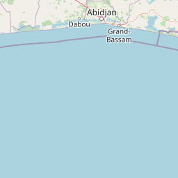
Map view of Assagny National Park

Use this park location map to pinpoint Assagny National Park in Ivory Coast, understand its exact geographic position, and read its mapped placement within the surrounding landscape more clearly.

Pigeon | © OpenStreetMap contributors
Park atlas

Browse mapped park geography and related conservation landscapes across the surrounding West African coastal region

Discover Other National Parks and Protected Areas Near Assagny National Park, Ivory Coast
Continue your park exploration beyond Assagny National Park by comparing other protected areas across Ivory Coast's coastal wetlands and nearby forest reserves. Trace the regional spread of conservation efforts, map diverse ecosystems, and understand how different protected landscapes connect within this vital geography.
National parkAbidjan

Banco National Park National Park: Primary Forest Landscape and Abidjan Geography

Explore mapped boundaries and urban conservation.

Banco National Park is a globally significant protected area, uniquely preserving dense primary tropical forest within the urban sprawl of Abidjan, Ivory Coast. This national park offers critical insights into urban conservation, featuring rare tree species and providing essential ecosystem services like water supply and carbon sequestration for the surrounding region. Its landscape, characterized by the Gbangbo River and rare mahogany and avodire trees, forms a vital geographic element within the metropolitan atlas.

Area
30 km²
Established
1953
IUCN
II
Relief
Lowland
National parkWestern North Region

Bia National Park: Ghana's Vital Protected Forest Landscape with West Africa's Tallest Trees

Explore the unique mapped geography and biodiversity of this key conservation area.

Bia National Park serves as a crucial protected landscape in Ghana's Western North Region, celebrated for harboring some of West Africa's tallest trees and a rich diversity of wildlife. This detailed entry provides context on its mapped boundaries and ecological significance as one of the last relatively untouched forest remnants in the region. Understand the park's place within Ghana's geography and its value for conservation research, showcasing its unique transitional forest ecosystem and the documented species it protects.

Area
563 km²
Established
1974
IUCN
II
Climate
Tropical
National parkSassandra-Marahoué District

Marahoué National Park: Protected Landscape and Geographic Setting in Ivory Coast

Mapped protected area boundaries and regional context.

Marahoué National Park represents a significant protected landscape within the Sassandra-Marahoué District, offering detailed geographic insights for atlas exploration. This entry focuses on the park's mapped boundaries and its identity as a national park, providing essential context for understanding its place in Ivory Coast's protected areas network. Discover the mapped terrain and regional landscape elements relevant to this protected natural site.

Area
1,000 km²
Established
1968
IUCN
II
Relief
Upland
National parkIvory Coast

Taï National Park: A Primary Rainforest Protected Area in Ivory Coast

Explore mapped boundaries and critical primate habitats in West Africa.

Taï National Park in Ivory Coast stands as a monumental protected landscape, comprising the largest contiguous area of primary rainforest remaining in West Africa. Its designation as a national park highlights its critical role in preserving biodiversity and unique geographic features. Users exploring this destination can delve into its mapped terrain, understand its regional landscape context within Ivory Coast, and appreciate its significance as a vital habitat for endangered species and an integral part of the Upper Guinean forest ecosystem.

Area
3,300 km²
Established
1972
IUCN
II
Relief
Upland
National parkGhana

Nini-Suhien National Park: Ghana's Coastal Forest Protected Landscape and Avian Sanctuary

Explore mapped boundaries of vital tropical forest habitat.

Nini-Suhien National Park in Ghana is recognized for its protected coastal forest, a habitat type critically endangered across West Africa. Established in 1976, this national park spans 160 square kilometers, serving as a key component of the Ankasa Conservation Area and a vital corridor for wildlife. Its designation as an Important Bird Area highlights its global importance for birdlife, offering a unique geographic and ecological study within the nation's atlas of protected lands.

Area
160 km²
Established
1976
IUCN
II
Relief
Lowland
National parkIvory Coast

Mont Péko National Park: Ivory Coast National Park with Mapped Boundaries

Explore its protected landscape and regional geography.

Delve into Mont Péko National Park, a designated national park within Ivory Coast, to understand its unique protected landscape. This entry facilitates detailed atlas exploration, focusing on its geographic placement, mapped boundaries, and contribution to the regional natural terrain. Discover the essence of this protected area through its mapped geography and landscape identity.

Area
340 km²
Established
1968
IUCN
II
Relief
Mountain
National parkSinoe County

Sapo National Park: Explore Its Protected Landscape and Geographic Identity in Sinoe County

Discover mapped park boundaries and regional context.

Delve into the protected landscape of Sapo National Park, a key national park located in Sinoe County, Liberia. This page provides essential context for understanding its geographic setting, mapped park boundaries, and its significance as a protected natural area. It serves as a foundational entry for exploring Liberia's protected lands within the broader atlas, focusing on landscape identity and regional geographic features.

Area
1,804 km²
Established
1983
IUCN
II
Relief
Mixed relief
National parkGhana

Bui National Park: Protected Savanna Landscape and Black Volta River Geography in Ghana

Explore the mapped boundaries and unique ecosystems of this national park.

Bui National Park, a protected national park in Ghana, offers a rich geographic discovery of savanna ecosystems bisected by the Black Volta River. Its vast mapped area provides a unique setting for understanding riparian corridors, woodland savanna, and mountainous terrain. The park is critically important for its significant hippopotamus population and its designation as an Important Bird Area, showcasing its ecological value. Exploration of Bui National Park provides insight into Ghana's protected landscapes and their strategic position within West African geography, serving as a key entity for any natural atlas.

Area
1,820 km²
Established
1971
IUCN
II
Relief
Mixed relief

Common questions about visiting, size, designation, and location context for Assagny National Park

Assagny National Park FAQs for park facts, access, geography, and protected area context
Find quick answers about Assagny National Park, including protected-area facts, park geography, trail and visitor context, and how the park fits into its surrounding country and regional landscape.
MoriAtlas Explorer

Continue Your Protected Areas Search Across the Global Atlas

Deepen your exploration by continuing the structured search for national parks and protected areas worldwide. Utilize the comprehensive filtering capabilities to compare different conservation landscapes and refine your understanding of global park geography. Discover more about the distribution and characteristics of protected natural areas.

Global natural geography