

Mori Atlas logo
National parkBadgingarra National Park

Discover the mapped boundaries and geographic context of this protected area in Western Australia.

Badgingarra National Park: National Park Atlas and Protected Landscape Identity

Badgingarra National Park stands as a significant protected area within the diverse geography of Western Australia. This page serves as an atlas-centric entry point, detailing the park's mapped boundaries and its role as a national park. Understand its specific landscape character and its place within the regional context, offering structured discovery for those interested in protected lands and geographic exploration.

National ParkWestern AustraliaWildflower DiversitySemi-Arid LandscapeBreakaway FormationsEndemic Flora

Badgingarra National Park

National park

Park overview

Structured park overview, official facts, and landscape profile for Badgingarra National Park

Badgingarra National Park park facts, protected area profile, and essential visitor context
Review the core facts for Badgingarra National Park, including designation, size, terrain, visitor scale, habitats, and operating context in one park-focused overview.

About Badgingarra National Park

Badgingarra National Park represents a preserved remnant of the unique semi-arid woodland and heath ecosystems that once covered much of Western Australia's wheatbelt region. The park's landscape is defined by a series of breakaway ridges that overlook extensive sandplains, creating a terrain of considerable visual and ecological interest. These breakaway formations, formed through millions of years of erosion, provide habitat for specialized plant species that thrive on the shallow soils and rocky outcrops of the cliff faces. The park's low scrub vegetation is dominated by a diverse array of species including the large-flowered mottlecah, various smokebush varieties, numerous Banksia and Verticordia species, and the distinctive kangaroo paw. Mullering Brook, which flows through the park, creates a permanent wetland area that supports additional plant and animal communities distinct from the surrounding drylands. The park's location within the Southwest Australia Biodiversity Hotspot, one of only 36 recognized biodiversity hotspots globally, underscores its importance in conserving plant species found nowhere else on the planet.

Quick facts and research context for Badgingarra National Park

Badgingarra National Park occupies 131.08 square kilometers of Western Australia's wheatbelt, established in 1973 under the management of the Parks and Wildlife Service. The park features distinctive breakaway country, which are eroded cliff formations that create a dramatic backdrop to the surrounding sandplains. The area supports an exceptional diversity of plant species, including numerous endemic and rare varieties such as the Badgingarra mallee and several Hakea species. The park lies adjacent to the small township of Badgingarra and is accessible via the Brand Highway, making it a notable destination for nature enthusiasts exploring the Mid West region.

Park context

Deeper park guide and search-rich context for Badgingarra National Park

Badgingarra National Park history, landscape, wildlife, and travel context
Explore Badgingarra National Park through its history, landscape character, ecosystems, wildlife, conservation priorities, cultural context, and seasonal travel timing in a structured park guide built for atlas discovery and search intent.

Why Badgingarra National Park stands out

Badgingarra National Park is best known for its incredible diversity of endemic wildflowers, which draw botanists and nature enthusiasts from across Australia. The park protects several rare and restricted plant species that occur nowhere else on Earth, including the Badgingarra mallee, Hakea flabellifolia, and Strangea cynanchicarpa. The landscape's combination of breakaway formations with low scrub vegetation creates a visually striking environment where mottlecah, smokebush, Banksia, Verticordia, and kangaroo paw create vibrant displays. This floral richness, set against the semi-arid terrain of the wheatbelt, represents one of the most significant concentrations of endemic plant diversity in southwestern Australia.

Badgingarra National Park history and protected-area timeline

Badgingarra National Park was established in 1973 as part of Western Australia's expanding network of national parks designed to protect the state's most significant natural landscapes and biodiversity. The establishment of the park came during a period of increased recognition of the unique flora and geological features of the wheatbelt region, which had previously been heavily cleared for agriculture. The park was created to preserve the area's exceptional plant diversity, including species that were already recognized as rare or restricted in their distribution. Management of the park falls to the Parks and Wildlife Service of Western Australia, which oversees conservation activities and visitor access. Over the decades, the park has become increasingly important as surrounding agricultural lands have been developed, leaving the protected area as a significant remnant of the original native vegetation.

Badgingarra National Park landscape and geographic character

The landscape of Badgingarra National Park is characterized by a striking contrast between the elevated breakaway country and the lower-lying sandplains that dominate the surrounding terrain. The breakaways are erosion-resistant sandstone and laterite ridges that form stepped cliff formations, providing panoramic views across the park and toward the township of Badgingarra. These geological features create a complex habitat mosaic, with cliff faces, rocky ledges, and steep slopes supporting different plant communities than the flatter sandplains below. The sandplains are covered in low scrub and heath vegetation that, while appearing monotonous from a distance, contains extraordinary botanical diversity. Mullering Brook cuts through the park in a shallow valley, creating a line of vegetation and a swampy area that provides ecological contrast to the drier surroundings. The park's elevation and position within the semi-arid wheatbelt results in a landscape that appears harsh yet supports remarkable life.

Badgingarra National Park ecosystems, habitats, and plant life

The ecological character of Badgingarra National Park is defined by its location within the Southwest Australia Biodiversity Hotspot, one of the world's most important centers of plant endemism. The park's plant communities represent a complex mosaic of species adapted to the nutrient-poor soils and seasonal drought conditions of the wheatbelt. The low scrub that covers most of the park includes numerous species from the Proteaceae, Myrtaceae, and Proteaceae families, with species such as mottlecah, various Banksia species, and Verticordia providing year-round interest. The park's significance is amplified by the presence of several rare and endemic species that are restricted to small areas near Badgingarra, including the Badgingarra mallee, which is known from only a handful of populations. The diversity of wildflowers, particularly during the spring blooming season, is extraordinary, with dozens of species creating carpets of color across the landscape. The park's vegetation also serves as important habitat for numerous animal species, though the semi-arid conditions limit the density of wildlife compared to more mesic environments.

Badgingarra National Park wildlife and species highlights

The fauna of Badgingarra National Park includes several notable species adapted to the semi-arid conditions of the wheatbelt. Western grey kangaroos are commonly seen grazing in the park, particularly during cooler parts of the day around dawn and dusk. Emus, Australia's largest native bird, traverse the landscape in pairs or small groups, their distinctive silhouettes a common sight against the horizon. Bustards, large ground-dwelling birds, inhabit the more open areas of the park where they feed on insects and vegetation. Wedgetail eagles soar overhead, using thermal currents to patrol for prey across the park's skies. The park's diverse plant communities also support a range of smaller animals including reptiles, small mammals, and numerous insect species that form the base of the food web. The Mullering Brook corridor provides habitat for water-dependent species and adds to the overall biodiversity of the park.

Badgingarra National Park conservation status and protection priorities

Badgingarra National Park plays a critical role in the conservation of Western Australia's unique flora, particularly given the extensive agricultural development that has transformed much of the surrounding wheatbelt. The park protects several plant species that are considered rare or restricted, including the Badgingarra mallee and several Hakea species, making it significant for botanical conservation at both state and national levels. However, the park faces significant threats, most notably from the spread of dieback, a Phytophthora-induced disease that attacks native plants and can fundamentally alter ecosystem composition. Dieback spread represents one of the most serious conservation challenges for southwestern Australia's native vegetation, as it can eliminate susceptible plant species and change the character of entire landscapes. The park's isolation within a predominantly agricultural landscape also means it functions as a refuge for species that can no longer survive in the surrounding cleared farmland.

Badgingarra National Park cultural meaning and human context

Badgingarra National Park is situated within the traditional Country of the Yued people, the Aboriginal inhabitants of the western wheatbelt region who have maintained connections to this landscape for thousands of years. The breakaway formations and the broader landscape would have held cultural significance for Indigenous communities, as these geological features often feature in Dreaming narratives and traditional resource management practices. While the park's documentation does not detail specific cultural sites or heritage values, the broader wheatbelt region contains numerous locations of Indigenous importance. The township of Badgingarra, which lies adjacent to the park, takes its name from the Noongar word for a local water source.

Top sights and standout views in Badgingarra National Park

Badgingarra National Park's most outstanding feature is its exceptional wildflower display, particularly during spring when species such as mottlecah, kangaroo paw, and numerous Verticordia create spectacular color throughout the park. The breakaway viewpoints offer sweeping views across the wheatbelt landscape, making the park particularly appealing for photography and landscape appreciation. The rare Badgingarra mallee represents a botanical highlight, being a species found almost exclusively within this protected area. The Mullering Brook wetland provides a contrasting environment within the dry landscape and supports different plant and animal communities. The park's location adjacent to the Brand Highway makes it accessible for day visitors exploring the Mid West region.

Best time to visit Badgingarra National Park

The optimal time to visit Badgingarra National Park is during the Australian spring months from August to October, when wildflower displays are at their most spectacular and the weather is generally mild and pleasant. Winter rains trigger the flowering of many species, resulting in the park's famous displays of color that attract visitors from across Western Australia. Summer months can be extremely hot, with temperatures often exceeding 40 degrees Celsius, making outdoor activities uncomfortable and potentially dangerous. Autumn and early winter offer cooler conditions for walking and landscape photography, though wildflower displays are less dramatic during these seasons. Visitors planning trips should check current conditions and be aware that the park's remote location means supplies should be carried from larger centers.
Park location guide

Geography guide, regional context, and park location map for Badgingarra National Park

Badgingarra National Park park geography, regions, and map view in Australia
Understand where Badgingarra National Park sits in Australia through a broader geographic reading of the surrounding landscape, nearby location context, and its mapped position within the national park landscape.

How Badgingarra National Park fits into Australia

Australia is a constitutional monarchy and federal parliamentary democracy comprising six states and ten territories. With a population of nearly 28 million, it is one of the world's most urbanised countries, with most people concentrated on the eastern seaboard. The country has a high Human Development Index and is known for its cultural diversity, ancient Aboriginal heritage, and unique wildlife.

Wider geography shaping Badgingarra National Park in Australia

Australia occupies the entire Australian continent, the island of Tasmania, and numerous smaller islands. It is the world's flattest and driest inhabited continent, featuring vast deserts in the interior (the Outback), tropical rainforests along the eastern coast, and a coastline bordering the Indian and Pacific Oceans.

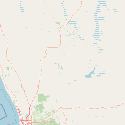
Map view of Badgingarra National Park

Use this park location map to pinpoint Badgingarra National Park in Australia, understand its exact geographic position, and read its mapped placement within the surrounding landscape more clearly.

Pigeon | © OpenStreetMap contributors

Location context for Badgingarra National Park

Western Australia
Park atlas

Compare adjacent national parks and explore connected protected landscapes across Western Australia

Discover Other National Parks Near Badgingarra National Park and the Western Australian Wheatbelt
Browse additional national parks and protected areas in the vicinity of Badgingarra National Park, spanning diverse landscapes across the Western Australian wheatbelt region. Compare these regional parks to understand connected conservation efforts, mapping their unique geological features and distinct flora alongside varied ecological zones.
Watercolor illustration of a landscape with green rolling hills and pink clouds
National parkWestern Australia

Nambul National Park: A Protected Landscape Within Western Australia's Geographic Context

Explore mapped boundaries and regional terrain context.

Nambul National Park represents a distinct protected area within the expansive geography of Western Australia. This detailed park page offers users an atlas-driven exploration of its identity as a national park, highlighting its mapped natural landscape and its regional significance. Understand the specific geographic features and protected land context that define Nambul National Park within Australia's largest state, fostering deeper geographic discovery.

Area
192.68 km²
Established
1994
IUCN
II
Relief
Upland
National parkWestern Australia

Drovers Cave National Park: Protected National Park Landscape in Western Australia

Discover the mapped geography and natural context of this park.

Drovers Cave National Park stands as a key protected area within the expansive Western Australian region. This national park offers a focused lens through which to explore its specific geographic identity and landscape characteristics. As a designated national park, it is mapped within the larger atlas of Australia's protected lands, providing users with structured insights into its regional setting and natural terrain.

Area
26.81 km²
Established
1972
IUCN
II
Relief
Lowland
National parkWestern Australia

Alexander Morrison National Park: Discover Its Protected Landscape and Regional Geography

Mapped protected area boundaries and landscape context in Western Australia.

Alexander Morrison National Park represents a core protected natural landscape within Western Australia. As a national park, its identity is deeply tied to its mapped geographic extent and its role in the regional atlas. This destination provides a focused lens on a specific protected area, enabling users to understand its unique landscape features and its contribution to the conservation estate of Western Australia. Delve into its protected status and geographic orientation within Australia's largest state.

Area
85 km²
Established
1970
IUCN
II
Relief
Upland
National parkWestern Australia

Watheroo National Park National Park: Mapping Protected Landscapes in Western Australia

Explore regional geography and mapped park boundaries.

Watheroo National Park represents a key protected landscape within the vast state of Western Australia. This detail page offers focused insight into the park's specific geographic character, its mapped boundaries, and its role within the regional atlas of protected areas. Understand the natural terrain and landscape context that defines this Australian national park.

Area
444.81 km²
Established
1969
IUCN
II
Relief
Upland
National parkWestern Australia

Lesueur National Park: Detailed National Park Atlas and Geographic Context

Explore the mapped protected landscape in Western Australia.

Lesueur National Park is a key protected area within the expansive geography of Western Australia. This resource provides detailed information on its national park status, mapped boundaries, and its significance within the regional atlas. Engage with the specific landscape identity of this protected territory and understand its role in the broader geographic context of Australia.

Area
272.35 km²
Established
1992
IUCN
II
Relief
Upland
National parkWestern Australia

Tathra National Park: Protected Landscape Identity and Mapped Geographic Boundaries

Western Australia national park exploration and regional context.

Delve into the protected landscape of Tathra National Park, a significant entity within Western Australia's network of natural areas. This detail provides a structured overview of its geographic position, mapped outlines, and ecological context, serving as a vital entry point for understanding Australia's diverse protected lands and regional geography.

Area
43.22 km²
Established
1970
IUCN
II
Relief
Upland
National parkWestern Australia

Yanchep National Park: Explore Its Unique Limestone Caves and Protected Bushland Geography

Discover the subterranean formations and coastal plain landscapes.

Yanchep National Park offers a singular opportunity for atlas-driven exploration of Western Australia's natural and cultural heritage. Situated on the Swan Coastal Plain, this national park is celebrated for its extensive network of limestone caves, including the notable Crystal Cave, providing a rare glimpse into subterranean geological processes. Beyond its underground wonders, the park encompasses diverse native bushland, supporting iconic koala colonies and offering insights into the region's ecological distinctiveness. Its deep Nyoongar heritage further enriches the understanding of this mapped protected landscape.

Area
28.76 km²
Established
1957
IUCN
II
Relief
Lowland
National parkWestern Australia

Neerabup National Park: Discover its Protected Landscape and Geographic Identity in Western Australia

Explore mapped boundaries and regional context.

Neerabup National Park represents a crucial protected landscape within Western Australia, offering a distinct geographic identity for atlas-based discovery. This page focuses on its role as a national park, detailing its mapped boundaries and situating it within the rich regional geography of Western Australia. Users can explore the park's unique natural terrain and understand its contribution to the state's protected areas.

Area
9.43 km²
Established
1965
IUCN
II
Relief
Lowland

Common questions about visiting, size, designation, and location context for Badgingarra National Park

Badgingarra National Park FAQs for park facts, access, geography, and protected area context
Find quick answers about Badgingarra National Park, including protected-area facts, park geography, trail and visitor context, and how the park fits into its surrounding country and regional landscape.
MoriAtlas Explorer

Continue Your Protected Areas Search Across the Global Atlas

Deepen your exploration by continuing the structured search for national parks and protected areas worldwide. Utilize the comprehensive filtering capabilities to compare different conservation landscapes and refine your understanding of global park geography. Discover more about the distribution and characteristics of protected natural areas.

Global natural geography