Mori Atlas logo
National parkBaie de Baly National Park

Discover the distinct natural terrain and regional setting of this national park in Boeny.

Baie de Baly National Park: Protected Landscape Geography and Mapped Boundaries

Baie de Baly National Park stands as a significant protected area within the Boeny region, offering a unique lens for geographic discovery. This page provides detailed insights into the park's mapped boundaries and its role as a protected landscape, contributing valuable context to the regional geography of Madagascar. Explore the natural terrain and understand the conservation significance of this important national park through an atlas-focused perspective.

Coastal Protected AreaDry Deciduous ForestMangrove EcosystemsCritical Conservation PriorityEndemic Species HabitatTortoise Conservation

Baie de Baly National Park

National park

Park overview

Structured park overview, official facts, and landscape profile for Baie de Baly National Park

Baie de Baly National Park park facts, protected area profile, and essential visitor context
Review the core facts for Baie de Baly National Park, including designation, size, terrain, visitor scale, habitats, and operating context in one park-focused overview.

About Baie de Baly National Park

Baie de Baly National Park represents one of Madagascar's most ecologically significant protected areas, established in 1997 to preserve a remarkable concentration of endemic species and diverse coastal habitats. The park occupies the Soaresala District in the Boeny region, stretching along the Mozambique Channel with its eastern boundary defined by the Bay of Marambitsy. The protected area encompasses a transitional landscape where dry deciduous forests meet coastal ecosystems, creating a mosaic of habitats that support extraordinary biodiversity. The park's establishment reflects Madagascar's commitment to conserving its unique evolutionary heritage, particularly species found nowhere else on Earth. With the Angonoka tortoise as its most celebrated inhabitant, the park serves not only as a refuge for critically endangered wildlife but also as an important model for community-based conservation in Madagascar. The governing body, Madagascar National Parks Association, works to balance ecological protection with sustainable land management practices that recognize the needs of local communities who share this landscape.

Quick facts and research context for Baie de Baly National Park

Baie de Baly National Park is located in the Soaresala District of Madagascar's Boeny region, approximately 150 kilometers south of the major city of Mahajanga. The park covers 571.42 square kilometers along the northern Madagascar coast, bordering the Mozambique Channel. It was established on December 18, 1997, and is managed by Madagascar National Parks Association. The park is bordered by Tsingy de Namoroka National Park to the west and encompasses the Bay of Marambitsy. The landscape features a mix of dry deciduous forests, scrubland, bamboo thickets, mangrove ecosystems, and savanna, intersected by the Andranomavo River. The park represents one of the most important conservation areas in Madagascar for critically endangered reptile species.

Park context

Deeper park guide and search-rich context for Baie de Baly National Park

Baie de Baly National Park history, landscape, wildlife, and travel context
Explore Baie de Baly National Park through its history, landscape character, ecosystems, wildlife, conservation priorities, cultural context, and seasonal travel timing in a structured park guide built for atlas discovery and search intent.

Why Baie de Baly National Park stands out

Baie de Baly National Park is world-renowned as the sole remaining natural habitat of the Angonoka tortoise, also known as the ploughshare tortoise, one of the rarest and most critically endangered tortoises on the planet. This park also protects significant populations of the Madagascar sideneck turtle, the Madagascar fish eagle, and serves as a refuge for marine mammals including the dugong. The combination of coastal mangrove systems, dry deciduous forests, and wetland habitats creates an exceptional biodiversity hotspot that supports 13 mammal species, 37 reptile species, 8 amphibian species, and 122 bird species, making it a flagship conservation area for northern Madagascar.

Baie de Baly National Park history and protected-area timeline

Baie de Baly National Park was established on December 18, 1997, as part of Madagascar's expanding network of protected areas designed to safeguard the island's extraordinary endemic biodiversity. The park's creation reflected growing international recognition of Madagascar's unique ecological significance and the urgent need to protect species facing extreme extinction risk. The Angonoka tortoise, discovered to be the park's most remarkable resident, had previously been poorly understood by science, and the park's designation helped focus conservation attention on this critically endangered species. The establishment also recognized the importance of the coastal and wetland habitats that had long supported local communities and provided essential ecosystem services. Since its creation, the park has become a focal point for conservation efforts targeting Madagascar's reptile fauna, with specific programs developed to protect the remaining populations of Angonoka tortoises in their natural habitat.

Baie de Baly National Park landscape and geographic character

The physical landscape of Baie de Baly National Park presents a striking combination of coastal and interior terrain along Madagascar's northern coastline. The park's northern boundary directly faces the Mozambique Channel, while the Bay of Marambitsy marks its eastern edge, creating a peninsula-like exposure to marine influences. Interior landscapes feature dry deciduous forests that transition into more open savanna habitats, with areas of scrub-shrub and dense bamboo thickets creating structural diversity. The Andranomavo River flows through the park, providing freshwater habitat and supporting riparian ecosystems, while the Kapiloza River forms the southern boundary. Swamp and lake environments punctuate the forest and savanna matrix, and extensive mangrove systems develop along the coast and around tidal channels. This topographic diversity, from coastal beach and mangrove to inland forest and savanna, creates a complex landscape that supports multiple ecological communities within a relatively compact protected area.

Baie de Baly National Park ecosystems, habitats, and plant life

The ecological character of Baie de Baly National Park reflects the meeting point of Madagascar's western dry forests and coastal marine environments. The park's vegetation communities include dry deciduous forests characterized by endemic tree species, open savanna dominated by grass and scattered shrubs, and dense bamboo shrub formations that create dense thickets in certain areas. Mangrove ecosystems along the coast and tidal zones represent particularly important habitat, providing nursery grounds for marine species and protecting the shoreline from erosion. The wetland systems, including lakes and swamps, add further ecological diversity to the park's interior. Particularly notable is the presence of Perrierbambus madagascariensis, an endemic bamboo species found within the park, and Erythrophleum couminga, a locally common but poisonous tree species known locally as komanga that produces hard wood unsuitable for cooking due to its toxic fumes.

Baie de Baly National Park wildlife and species highlights

Baie de Baly National Park harbors an exceptional concentration of endemic and threatened wildlife, with its most globally significant resident being the Angonoka tortoise, found nowhere else in the wild. This critically endangered species, also known as the ploughshare tortoise for the distinctive flared scutes on its shell, represents one of the rarest reptiles on Earth and the primary reason the park holds international conservation importance. The Madagascar sideneck turtle, another endemic reptile, inhabits the park's freshwater systems. Marine wildlife includes the dugong, a protected marine mammal that grazes on seagrass in coastal waters. The Madagascar fish eagle, a striking raptor endemic to the island, hunts along the park's waterways and coastline. The park supports 13 mammal species including six primate species, 37 reptile species, 8 amphibian species, and 122 bird species, creating a remarkably biodiverse community within this coastal protected area.

Baie de Baly National Park conservation status and protection priorities

Baie de Baly National Park holds exceptional conservation significance as the only known natural habitat of the Angonoka tortoise, classified as critically endangered by the International Union for Conservation of Nature. This single species alone justifies the park's protected status and makes it a global priority for reptile conservation. The park also contributes to the protection of other endangered species including the Madagascar sideneck turtle and the dugong, both facing significant population declines across their ranges. The diverse habitat types within the park, spanning from coastal mangroves to inland forests, provide ecosystem services that extend beyond species protection to include coastal defense, water filtration, and carbon storage. The park's designation as IUCN Category II reflects its primary function as a national park dedicated to ecosystem conservation and visitor enjoyment while maintaining strict protection for endangered species.

Baie de Baly National Park cultural meaning and human context

The park exists within a landscape that has supported human communities for generations, with the local population relying on the region's natural resources for livelihoods through traditional activities. The Andranomavo River and coastal waters provide fishing opportunities for nearby communities, while the forests have historically been managed through shifting cultivation practices adapted to the seasonal dry conditions. The local name for the poisonous Erythrophleum tree, komanga, reflects traditional ecological knowledge about the region's flora. Conservation efforts in the park recognize the importance of engaging with local communities to ensure that protection measures do not undermine traditional livelihoods and that local people benefit from conservation activities.

Top sights and standout views in Baie de Baly National Park

The defining highlight of Baie de Baly National Park is its status as the world's last refuge for the critically endangered Angonoka tortoise, a species that cannot be found in any other protected area globally. The park's coastal location where the Mozambique Channel meets Madagascar's dry western forests creates a visually distinctive landscape of mangroves, beaches, and forest-covered terrain. The presence of the Madagascar fish eagle, one of the island's most iconic endemic raptors, adds another dimension of wildlife interest for visitors. The park's proximity to Tsingy de Namoroka National Park creates opportunities for regional exploration, and the diverse habitat mosaic supports wildlife viewing across multiple ecosystems within a single visit.

Best time to visit Baie de Baly National Park

The optimal period to visit Baie de Baly National Park aligns with the dry season in northern Madagascar, typically spanning April through November. During this timeframe, reduced rainfall creates more accessible trail conditions and wildlife becomes more concentrated around remaining water sources, enhancing viewing opportunities. The dry season also corresponds with cooler overall temperatures and lower humidity, making outdoor exploration more comfortable. The park's coastal location means that sea conditions may vary seasonally, with the calmer period generally corresponding to the dry season. Visitors should note that Madagascar's wet season, from December to March, can result in flooded trails and reduced accessibility, though the landscape takes on a different character with renewed vegetation growth.
Park location guide

Geography guide, regional context, and park location map for Baie de Baly National Park

Baie de Baly National Park park geography, regions, and map view in Madagascar
Understand where Baie de Baly National Park sits in Madagascar through a broader geographic reading of the surrounding landscape, nearby location context, and its mapped position within the national park landscape.

How Baie de Baly National Park fits into Madagascar

Madagascar is an island nation in the Indian Ocean, positioned off the southeastern coast of Africa. As the world's fourth-largest island and second-largest island country, it stands out for its exceptional biodiversity, over 90% of its wildlife is endemic, making it one of 17 megadiverse countries. The population is approximately 32 million, with Antananarivo as both the capital and largest city.

Wider geography shaping Baie de Baly National Park in Madagascar

Madagascar lies in the Indian Ocean off the southeastern coast of Africa, separated from the mainland by the Mozambique Channel. The island is situated approximately 400 km from the African continent. As the world's fourth-largest island, it also includes numerous smaller peripheral islands.

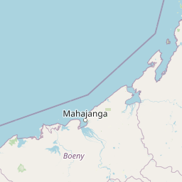
Map view of Baie de Baly National Park

Use this park location map to pinpoint Baie de Baly National Park in Madagascar, understand its exact geographic position, and read its mapped placement within the surrounding landscape more clearly.

Pigeon | © OpenStreetMap contributors

Location context for Baie de Baly National Park

Boeny
Park atlas

Map nearby protected areas, comparing diverse landscapes across northern Madagascar's unique conservation zones.

Explore Other National Parks Near Baie de Baly, Tracing Madagascar's Protected Coastal and Inland Geography
Explore other national parks and protected areas near Baie de Baly National Park, tracing Madagascar's coastal geography and interior forest conservation landscapes. Compare diverse protected ecosystems, from dry deciduous forests to mangrove swamps, understanding the regional spread of habitats and critical conservation priorities.
National parkBoeny Region

Ankarafantsika National Park: Protected Area Atlas and Regional Geography Discovery

Explore mapped boundaries and natural landscape context.

Ankarafantsika National Park serves as a key protected area for understanding the geography of Madagascar's Boeny Region. This canonical page offers a detailed atlas-style view, highlighting the park's mapped boundaries and its role as a distinct natural landscape. Engage with structured geographic data to comprehend the park's protected status and its contribution to the regional terrain, facilitating a deeper appreciation of protected lands.

Area
1,365.13 km²
Established
2002
IUCN
II
Relief
Lowland
National parkMelaky

Tsingy de Bemaraha National Park: A Protected Landscape within Melaky, Madagascar

Explore mapped boundaries and regional geography for atlas discovery.

Tsingy de Bemaraha National Park is a designated national park offering profound opportunities for geographic discovery. As a key protected area in the Melaky region, its mapped boundaries and natural landscape characteristics are vital for understanding Madagascar's conservation geography. This resource facilitates detailed atlas exploration, providing structured insights into the park's terrain and its position within the broader regional context, enabling a focused study of its protected land identity.

Area
723.4 km²
Established
1997
IUCN
II
Visitors
10.1K annual
National parkMadagascar

Zahamena National Park: Madagascar National Park Exploration and Geographic Context

Mapping the protected boundaries and landscape of Zahamena National Park.

Delve into Zahamena National Park, a vital protected territory situated in Madagascar. This national park offers a unique perspective on the island's natural geography and its status as a significant protected landscape. Understand its position within Madagascar's broader context, focusing on the mapped aspects of its protected area identity and its contribution to the country's renowned biodiversity hotspot status.

Area
423 km²
Established
1997
IUCN
II
Relief
Mountain
Watercolor illustration of a mountainous landscape with a lake and grassy fields.
National parkAnjouan

Mount Ntringui National Park: Protected Volcanic Landscape and Highland Geography on Anjouan

Explore its dramatic peaks, crater lake, and remnant montane forests.

Mount Ntringui National Park is a significant protected area situated in the rugged volcanic highlands of Anjouan. This national park preserves the island's highest peaks, Mount Ntringui and Mount Trindrini, alongside the unique Dzialandzé crater lake and the crucial Moya Forest. It stands as a vital refuge for endemic species and represents the last substantial tract of montane forest on Anjouan, offering deep insights into the region's unique ecology and mapped natural terrain.

Area
79.14 km²
Established
2010
IUCN
II
Relief
Mountain
National parkMadagascar

Lokobe National Park: Madagascar's Protected Natural Landscape and Geographic Context

Explore mapped boundaries and regional park geography.

Lokobe National Park is a protected national park situated within Madagascar, an island country recognized globally for its exceptional biodiversity and unique ecosystems. This page offers a detailed, atlas-oriented perspective on Lokobe National Park, focusing on its designation as a protected area, its specific geographic location, and the natural landscape features that define its territory. Users can explore the park's mapped boundaries and understand its contribution to Madagascar's remarkable natural heritage.

Area
15.23 km²
Established
1927
IUCN
II
Climate
Tropical
National parkAnjouan

Shisiwani National Park: Anjouan's Protected Marine and Island Landscape Atlas

Coastal and terrestrial protected area mapping in Comoros.

Delve into the protected landscape of Shisiwani National Park, a critical national park situated on Anjouan's Sima Peninsula in Comoros. This atlas entry details the park's combined marine and terrestrial boundaries, highlighting its vital coral reefs, mangrove forests, and unique island geography. Understand the park's role in conservation through its mapped extent and diverse natural environments, offering a clear geographic context for protected area exploration.

Area
64.97 km²
Established
2016
IUCN
II
Climate
Tropical
National parkAlaotra-Mangoro

Andasibe-Mantadia National Park: National Park and Protected Landscape Identity

Explore its mapped boundaries and geographic context.

Andasibe-Mantadia National Park is a distinct protected territory within the Alaotra-Mangoro region, serving as a crucial focal point for understanding Madagascar's regional geography and protected land distribution. This detail page provides essential atlas-style information on the park's mapped area and its natural landscape characteristics. Engage with structured data that highlights the park's protected status and its position within the broader geographic framework of eastern Madagascar, supporting focused discovery for researchers and explorers.

Area
155 km²
Established
1989
IUCN
II
Visitors
26.1K annual
National parkComoros

Mohéli National Park: Comoros National Park and Protected Landscape Exploration

Mapped geography and protected area identity.

Mohéli National Park is a dedicated national park within the Comoros, providing a specific focus for exploring protected lands and their geographic distribution. This entry details the park's mapped boundaries and its significance as a conservation landscape. Understanding Mohéli National Park offers valuable insight into the regional geography of the Comoros archipelago and its unique natural context.

Area
643.62 km²
Established
2010
Relief
Mixed relief
Climate
Tropical

Common questions about visiting, size, designation, and location context for Baie de Baly National Park

Baie de Baly National Park FAQs for park facts, access, geography, and protected area context
Find quick answers about Baie de Baly National Park, including protected-area facts, park geography, trail and visitor context, and how the park fits into its surrounding country and regional landscape.
MoriAtlas Explorer

Continue Your Protected Areas Search Across the Global Atlas

Deepen your exploration by continuing the structured search for national parks and protected areas worldwide. Utilize the comprehensive filtering capabilities to compare different conservation landscapes and refine your understanding of global park geography. Discover more about the distribution and characteristics of protected natural areas.

Global natural geography