Mori Atlas logo
National parkBalbalasang–Balbalan National Park

Discover the mapped landscape and regional context of this protected national park.

Balbalasang–Balbalan National Park: Philippines National Park Geography and Protected Area Atlas

Balbalasang–Balbalan National Park represents a significant protected area within the Cordillera Administrative Region of the Philippines. As a national park, its geographic scope and mapped boundaries contribute to a deeper understanding of regional landscapes. This page serves as an atlas-focused entry point for exploring the park's natural terrain and its place within the broader protected land context, enabling structured discovery of its unique geographic identity.

National ParkPine ForestsEndemic SpeciesImportant Bird AreaCordillera CentralLuzon Biogeographic Region

Balbalasang–Balbalan National Park

National park

Park overview

Structured park overview, official facts, and landscape profile for Balbalasang, Balbalan National Park

Balbalasang, Balbalan National Park park facts, protected area profile, and essential visitor context
Review the core facts for Balbalasang, Balbalan National Park, including designation, size, terrain, visitor scale, habitats, and operating context in one park-focused overview.

About Balbalasang, Balbalan National Park

Balbalasang–Balbalan National Park stands as a testament to the ecological richness of northern Luzon's Cordillera Central mountain range. Located in the municipality of Balbalan in Kalinga province, the park has earned the moniker green heart of the Cordillera for its pristine forests and remarkable biodiversity. The terrain is characterized by two distinct mountain ranges with rugged slopes, deep valleys, and an extensive network of rivers and creeks that collectively drain into the Saltan River system. Mount Sapocoy dominates the western boundary of the park, offering views extending toward the Ilocos Region and Cagayan Valley on clear days, while the lower elevations around Balbalan in the eastern portion provide access to the park's diverse habitats. The park's ecological significance was formally recognized in 1972 when it was declared a national park under Republic Act No. 6463, and this protection was strengthened in 2022 when Republic Act No. 11688 integrated the national park and Banao watershed into the expanded Banao Protected Landscape. This consolidation reflects a growing recognition that watershed protection and ecosystem integrity require landscape-scale conservation approaches rather than isolated protected areas.

Quick facts and research context for Balbalasang, Balbalan National Park

Balbalasang–Balbalan National Park spans 1,338 hectares in Kalinga province, Philippines, within the Cordillera Administrative Region. The park centers on Mount Balbalasang and encompasses two mountain ranges in the Cordillera Central. Elevation ranges from 700 meters at Balbalan to 2,456 meters at Mount Sapocoy. The park belongs to the Luzon Biogeographic Region, a recognized center of endemism. It was established in 1972 and was redesignated in 2022 as part of the larger Banao Protected Landscape. The area is known for its intact pine forests and high concentration of endemic species.

Park context

Deeper park guide and search-rich context for Balbalasang, Balbalan National Park

Balbalasang, Balbalan National Park history, landscape, wildlife, and travel context
Explore Balbalasang, Balbalan National Park through its history, landscape character, ecosystems, wildlife, conservation priorities, cultural context, and seasonal travel timing in a structured park guide built for atlas discovery and search intent.

Why Balbalasang, Balbalan National Park stands out

Balbalasang, Balbalan National Park is best known for its exceptional biodiversity and status as one of the most intact pine forest ecosystems in the Cordillera region. The park hosts a remarkable concentration of endemic species, including 39 bird species found nowhere else in the Philippines and two exclusively in Luzon. The discovery of a Rafflesia species within the park adds to its botanical significance. Its designation as an Important Bird Area by BirdLife International reflects its global conservation importance for species such as the chestnut-faced babbler. The park is also notable for hosting vulnerable bird species including the whiskered pitta, Luzon water-redstart, and Luzon jungle flycatcher, as well as endangered mammals like the Luzon pygmy fruit bat and Luzon bushy-tailed cloud rat.

Balbalasang, Balbalan National Park history and protected-area timeline

Balbalasang–Balbalan National Park was established on June 17, 1972 through Republic Act No. 6463, making it one of the earlier national park designations in the Philippines. The legislation recognized the outstanding ecological and scenic value of the Mount Balbalasang area and its surrounding landscapes within the Cordillera Central. For five decades, the park functioned as a dedicated protected area under the management of the Department of Environment and Natural Resources. In 2022, the legal framework for protecting this landscape was significantly expanded when Republic Act No. 11688 merged the national park with the adjacent Banao watershed to create the Banao Protected Landscape. This legislative change reflected an evolution in conservation thinking toward protecting entire watersheds and ecological connectivity rather than focusing solely on the core protected area. The merger acknowledged that the ecological integrity of Mount Balbalasang depends on the surrounding watershed that feeds its rivers and supports its biodiversity.

Balbalasang, Balbalan National Park landscape and geographic character

The physical landscape of Balbalasang–Balbalan National Park is characterized by steep mountainous terrain within the Cordillera Central, one of the most prominent mountain ranges in the Philippines. The park encompasses two distinct mountain ranges with elevations ranging from 700 meters at the eastern boundary near Balbalan to 2,456 meters at Mount Sapocoy in the western portion of the park. This dramatic elevation gradient creates diverse microclimates and habitat zones throughout the protected area. Numerous rivers and creeks traverse the landscape, all flowing toward the Saltan River system that drains the broader watershed. The terrain features deep valleys carved by watercourses and ridgelines that define the park's boundaries. From the higher peaks, particularly Mount Sapocoy, visitors can perceive the geographical position overlooking both the Ilocos Region to the west and the Cagayan Valley to the east, situating the park at a significant topographic crossroads in northern Luzon.

Balbalasang, Balbalan National Park ecosystems, habitats, and plant life

The ecological character of Balbalasang–Balbalan National Park is defined by its location within the Luzon Biogeographic Region, one of the world's recognized centers of endemism. At elevations above 1,000 meters, the park supports a complex mosaic of hardwood forests, pine forests, and mossy forests that represent some of the most intact remaining forest cover in the Cordillera. The pine forests in particular are considered among the most well-preserved in the region. The discovery of a Rafflesia species within the park highlights the ongoing botanical discoveries possible in this relatively underexplored area. The park's designation within the Luzon Biogeographic Region places it in a global context of biodiversity significance, as this region hosts numerous species found nowhere else on Earth. The combination of elevation range, forest types, and watershed systems creates a heterogeneity of habitats that supports the remarkable species diversity documented within the park boundaries.

Balbalasang, Balbalan National Park wildlife and species highlights

The wildlife population in Balbalasang–Balbalan National Park demonstrates exceptional biodiversity, with 89 species of birds recorded within its boundaries. Of these, 39 species are endemic to the Philippines and two are found exclusively in Luzon: the Isabela oriole and the flame-breasted fruit dove. Four bird species present in the park are categorized as vulnerable according to the IUCN Red List, including the whiskered pitta, Luzon water-redstart, and Luzon jungle flycatcher. The park's significance as an Important Bird Area derives from its population of chestnut-faced babblers. Mammal diversity includes 23 documented species, among them the Philippine warty pig, Luzon striped rat, and Northern Luzon giant cloud rat. Two mammal species present are classified as endangered: the Luzon pygmy fruit bat and the Luzon bushy-tailed cloud rat. The reptile collection comprises 13 species, while amphibians are represented by 13 species including the Kalinga narrowmouth toad and Luzon narrow-mouthed frog. Additionally, 25 species of earthworms have been documented, reflecting the complex soil ecosystems supporting the above-ground biodiversity.

Balbalasang, Balbalan National Park conservation status and protection priorities

Balbalasang–Balbalan National Park holds significant conservation value at both national and international levels. Its designation as an Important Bird Area by BirdLife International acknowledges the park's role in supporting globally significant bird populations, particularly the chestnut-faced babbler. The presence of vulnerable species including the whiskered pitta, Luzon water-redstart, and Luzon jungle flycatcher, along with endangered mammals such as the Luzon pygmy fruit bat and Luzon bushy-tailed cloud rat, underscores the park's importance for species that face threats across their ranges. The park's location within the Luzon Biogeographic Region positions it as a key conservation area for endemic species, with 39 Philippines-endemic bird species relying on its habitats. The 2022 expansion of protection through the creation of the Banao Protected Landscape, which incorporated both the national park and the Banao watershed, reflects a more holistic approach to conservation that recognizes the interdependence of forest ecosystems, watershed function, and biodiversity persistence.

Balbalasang, Balbalan National Park cultural meaning and human context

The park is situated within the ancestral lands of indigenous communities in Kalinga province, a region with deep cultural ties to the mountainous landscape. The municipality of Balbalan itself takes its name from the Ilocano term for a species of tree native to the area, reflecting the longstanding relationship between local communities and the forest environment. While the Wikipedia source provides limited detail on cultural aspects, the Cordillera region is historically home to various indigenous peoples whose traditional land management practices have shaped the landscape over generations. The park's location near the provincial border with Abra places it at the intersection of different indigenous territories and cultural landscapes. Any cultural context related to the park would be intertwined with the broader history of Cordillera communities and their relationship with the mountainous environment.

Top sights and standout views in Balbalasang, Balbalan National Park

Balbalasang–Balbalan National Park offers several standout features that distinguish it within the Philippine protected area system. The park contains some of the most intact pine forests remaining in the Cordillera region, providing critical habitat for species found nowhere else. The presence of a Rafflesia species adds a botanical highlight of international interest. The elevation gradient from 700 to 2,456 meters creates diverse ecological zones within a relatively compact area, allowing visitors to experience multiple habitat types. The bird diversity is exceptional, with 89 species including 39 endemics, and the park supports populations of vulnerable species that draw attention from conservation researchers. The views from Mount Sapocoy spanning toward the Ilocos Region and Cagayan Valley provide a scenic highlight for those who reach the higher elevations. The recent expansion into the Banao Protected Landscape demonstrates the park's evolving role in regional conservation planning.

Best time to visit Balbalasang, Balbalan National Park

The optimal time to visit Balbalasang–Balbalan National Park aligns with the general climate patterns of northern Luzon, where the dry season typically extends from November to May and the wet season prevails from June to October. The dry months generally offer more accessible trails and clearer visibility for mountain views, particularly from the higher elevations around Mount Sapocoy. However, the wet season transforms the landscape with lush vegetation and full watercourses, which may appeal to visitors interested in experiencing the park's hydrological character. Given the park's elevation range and forest types, conditions can vary significantly between the lower and higher areas. Visitors planning trips should be prepared for variable weather and should check current conditions with local authorities, as the park's management and access arrangements may have evolved following the 2022 integration into the Banao Protected Landscape.
Park location guide

Geography guide, regional context, and park location map for Balbalasang, Balbalan National Park

Balbalasang, Balbalan National Park park geography, regions, and map view in Philippines
Understand where Balbalasang, Balbalan National Park sits in Philippines through a broader geographic reading of the surrounding landscape, nearby location context, and its mapped position within the national park landscape.

How Balbalasang, Balbalan National Park fits into Philippines

The Philippines, officially the Republic of the Philippines, is an archipelagic nation in Southeast Asia comprising approximately 7,641 islands categorized into three main geographical divisions: Luzon, Visayas, and Mindanao. Located in the western Pacific Ocean, it shares maritime borders with Taiwan, Japan, Palau, Indonesia, Malaysia, Vietnam, and China. Manila serves as the capital city, while Quezon City is the most populated city, both within Metro Manila.

Wider geography shaping Balbalasang, Balbalan National Park in Philippines

The Philippines is an archipelagic nation in Southeast Asia, positioned in the western Pacific Ocean. Its islands are bounded by the South China Sea to the west, Philippine Sea to the east, and Celebes Sea to the south. The country shares maritime borders with Taiwan to the north, Japan to the northeast, Palau to the east and southeast, Indonesia to the south, Malaysia to the southwest, Vietnam to the west, and China to the northwest.

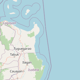
Map view of Balbalasang, Balbalan National Park

Use this park location map to pinpoint Balbalasang, Balbalan National Park in Philippines, understand its exact geographic position, and read its mapped placement within the surrounding landscape more clearly.

Pigeon | © OpenStreetMap contributors

Location context for Balbalasang, Balbalan National Park

Cordillera Administrative Region
Park atlas

Compare adjacent national parks and conservation landscapes across northern Luzon's diverse mountain geography

Discover Other Protected Areas Near Balbalasang–Balbalan National Park in the Cordillera
Continue exploring Balbalasang–Balbalan National Park by browsing other protected areas and national parks throughout the Cordillera Central and northern Luzon, tracing mapped terrain and unique ecological zones. Delve into the regional context of the Philippines' mountainous conservation efforts, comparing park geography, forest reserves, and watershed landscapes around the Kalinga province.
Watercolor painting of a landscape with rolling hills, trees, distant mountains, and small structures
National parkAbra

Cassamata Hill National Park: Philippine National Park with Hilltop Views of Abra Valley

Mapped geography of the Abra River valley and surrounding mountain ranges.

Cassamata Hill National Park is a protected landscape in Abra, Philippines, notable for its summit viewpoints that capture the expansive Abra River valley and the imposing Cordillera Central and Ilocos mountain ranges. Visitors can explore the mapped terrain from this elevated vantage point, offering a comprehensive view of the regional geography, including the distinctive silhouette of Mount Banti Goolong, also known as the Sleeping Beauty. This national park provides crucial insight into the protected area's context within the broader Cordillera region.

Area
0.57 km²
Established
1974
IUCN
V
Relief
Upland
National parkIlocos Sur

Northern Luzon Heroes Hill National Park: Coastal Mountain Geography and Protected Landscape Identity

Discover the mapped terrain and forest boundaries of this Philippine national park.

Northern Luzon Heroes Hill National Park offers a detailed look at a unique protected landscape in the Philippines' Ilocos Sur region. Its dramatic coastal mountain geography, characterized by steep forested slopes and ravines, stands apart from the typical flat terrain of the area. This national park serves as a significant mapped natural area, preserving vital forest cover and providing insights into the region's ecological context and landscape diversity.

Area
13.16 km²
Established
1963
IUCN
V
Relief
Mixed relief
National park

Fuyot Springs National Park: Philippines Protected Area with Springs, Caves & Waterfalls

Explore Sierra Madre mountain terrain and natural landscape features.

Fuyot Springs National Park offers a detailed look at a unique protected landscape within the Philippines' Sierra Madre mountain range. This atlas perspective focuses on the park's defining natural springs, its exploration-ready cave systems such as Main Cave and Altar Cave, and scenic features like Pinzal Falls. Understand the geographic context of this protected area and its mountainous terrain for landscape discovery.

Area
8.19 km²
Established
1938
IUCN
V
Relief
Mountain
National parkNueva Vizcaya

Bangan Hill National Park: A Protected Landscape within Nueva Vizcaya's Geography

Explore its mapped terrain and cultural significance.

Bangan Hill National Park is a crucial protected area nestled in Nueva Vizcaya, Philippines. This page details its specific geography, including its role as a distinct hill within the broader Cagayan Valley landscape. Users can explore the park's mapped boundaries, understand its role as a national park, and discover the surrounding mountain context of the Caraballo and Cordillera Central ranges. It offers a unique perspective on the region's natural and historical significance, serving as a focal point for protected landscape exploration.

Area
0.139 km²
Established
1995
IUCN
II
Relief
Mixed relief
National parkPangasinan

Hundred Islands National Park: Detailed Map and Protected Landscape Context in Pangasinan

National Park in Pangasinan, Philippines

Explore Hundred Islands National Park, a protected natural landscape in Pangasinan, Philippines. This page provides detailed geographic context, highlighting the park's mapped boundaries and its status as a national park. Understand its placement within the regional geography and appreciate the structured discovery value for atlas-based exploration of this significant protected area.

Area
16.76 km²
Established
1940
IUCN
II
Relief
Mixed relief
National parkPhilippines

Aurora Memorial National Park: A Protected Landscape in the Philippines' Sierra Madre

Explore mapped boundaries and endemic avian habitat.

Aurora Memorial National Park represents a critical conservation area situated within the Philippines' Sierra Madre mountain range. Spanning a significant stretch along the eastern mountain slopes, this national park is characterized by its lowland dipterocarp forest ecosystem, recognized for supporting diverse flora and fauna. It is particularly noted as an Important Bird Area, crucial for endemic species like the Philippine eagle and various other avian populations, highlighting its ecological significance within the archipelago's geography.

Area
56.76 km²
Established
1937
IUCN
V
Relief
Mountain
Illustration of a river with bamboo boats, people rowing, limestone cliffs, and trees
National parkNueva Ecija

Minalungao National Park: Protected Landscape and Geographic Context in Nueva Ecija

Explore the mapped boundaries of this Philippines national park.

Delve into the specifics of Minalungao National Park, a protected natural area identified as a national park in the Philippines. This exploration focuses on its distinct geographic identity within Nueva Ecija, highlighting the importance of its mapped boundaries and regional landscape. Understand the park's role as a protected land entity for atlas-based discovery.

Area
20.18 km²
Established
1967
IUCN
V
Relief
Upland
National parkBulacan

Biak-na-Bato National Park: National Park Atlas and Geographic Context in Bulacan

Explore protected landscapes and mapped terrain.

Biak-na-Bato National Park is a key protected area in Bulacan, Philippines, identified for its national park designation. This entry provides specific details on its geographic positioning and mapped features, essential for atlas-based research and understanding the distribution of protected lands within the region. Dive into the landscape context and mapped boundaries that define this significant natural entity.

Area
21.17 km²
Established
1937
IUCN
V
Relief
Mountain

Common questions about visiting, size, designation, and location context for Balbalasang, Balbalan National Park

Balbalasang, Balbalan National Park FAQs for park facts, access, geography, and protected area context
Find quick answers about Balbalasang, Balbalan National Park, including protected-area facts, park geography, trail and visitor context, and how the park fits into its surrounding country and regional landscape.
MoriAtlas Explorer

Continue Your Protected Areas Search Across the Global Atlas

Deepen your exploration by continuing the structured search for national parks and protected areas worldwide. Utilize the comprehensive filtering capabilities to compare different conservation landscapes and refine your understanding of global park geography. Discover more about the distribution and characteristics of protected natural areas.

Global natural geography