Mori Atlas logo
National parkBoumba Bek National Park

Mapping the protected area boundaries and regional geography of Boumba Bek National Park.

Boumba Bek National Park: Central African National Park and Protected Landscape Explorer

Boumba Bek National Park represents a significant protected landscape within the East Province of Cameroon. As a designated national park, it offers a focused point for exploring its mapped geographic identity and its role within the broader regional atlas. This page serves as a canonical entry for understanding the park's specific protected area context and landscape characteristics within the structured discovery environment.

Lowland RainforestAfrican Forest ElephantIUCN Category IICongo BasinImportant Bird AreaTRIDOM Corridor

Boumba Bek National Park

National park

Park overview

Structured park overview, official facts, and landscape profile for Boumba Bek National Park

Boumba Bek National Park park facts, protected area profile, and essential visitor context
Review the core facts for Boumba Bek National Park, including designation, size, terrain, visitor scale, habitats, and operating context in one park-focused overview.

About Boumba Bek National Park

Boumba Bek National Park represents one of central Africa's most significant protected forest landscapes, encompassing nearly 2,400 square kilometers of contiguous lowland rainforest in the remote southeastern region of Cameroon. The park derives its name from the two major river systems that flank its boundaries, the Boumba River to the west and the Bek River to the east, creating a distinct hydrological identity for this protected area. Established through a decree by the Cameroonian government in October 2005, the park emerged from a broader regional conservation movement that saw seven central African leaders commit to expanded forest protection during a summit in Brazzaville earlier that year. The park is managed in partnership with the World Wildlife Fund, which has played a central role in its conservation planning and monitoring activities. Access to the interior of the park remains challenging, with visitors and researchers dependent on traditional pirogue travel along the river systems and a network of historic hunting trails that penetrate the forest. The surrounding region has an estimated population of 33,000 people, including both Bantu ethnic groups and Baka Pygmy communities whose ancestral lands encompass portions of the protected area.

Quick facts and research context for Boumba Bek National Park

Boumba Bek National Park covers 2,382 square kilometers of primarily semi-evergreen lowland rainforest in southeast Cameroon, situated between the Boumba and Bek Rivers near the towns of Yokadouma and Moloundou. The park was established in 2005 and is governed in partnership with the World Wildlife Fund. It holds IUCN Category II protected area status and has been designated an Important Bird Area by BirdLife International. The area experiences a tropical climate with average temperatures around 24°C and annual rainfall of approximately 1,500 millimeters, distributed across two rainy seasons. Sixteen forest clearings known locally as bais have been documented within the park, four of which are actively monitored for large mammal activity.

Park context

Deeper park guide and search-rich context for Boumba Bek National Park

Boumba Bek National Park history, landscape, wildlife, and travel context
Explore Boumba Bek National Park through its history, landscape character, ecosystems, wildlife, conservation priorities, cultural context, and seasonal travel timing in a structured park guide built for atlas discovery and search intent.

Why Boumba Bek National Park stands out

Boumba Bek National Park is most renowned for its extraordinary concentration of African forest elephants, representing one of the highest density populations in central Africa. The park also protects significant populations of chimpanzees, forest antelopes including bongos, and Nile crocodiles, alongside approximately 300 fish species in its river systems. The designation as an Important Bird Area by BirdLife International highlights its avifauna significance within the Congo Basin forest ecosystem. The park's extensive semi-evergreen lowland rainforest, patches of closed-canopy evergreen forest, and seasonal swamp-forest create a complex habitat matrix that supports remarkable biodiversity in one of Africa's most threatened forest regions.

Boumba Bek National Park history and protected-area timeline

The conservation history of Boumba Bek reflects the broader challenges facing central Africa's forest ecosystems during the late twentieth and early twenty-first centuries. The area was first officially protected in 1995 when it received designation as an Essential Protection Zone, recognizing its ecological significance even before formal establishment as a national park. The formal creation of Boumba Bek National Park occurred on October 17, 2005, when the Cameroonian government decreed its establishment alongside adjacent Nki National Park as part of a coordinated regional conservation strategy. This establishment followed a landmark summit held in Brazzaville, Republic of Congo, in February 2005, where seven central African heads of state committed to expanding and connecting protected areas across the Congo Basin. The park has never undergone commercial logging, preserving its old-growth forest character, though poaching emerged as a significant threat beginning in the late 1980s during Cameroon's economic depression, when local populations were drawn into wildlife exploitation through financial incentives offered by intermediaries. Cameroon and Gabon are currently collaborating through the TRIDOM initiative to create a tri-national interzone connecting Boumba Bek with Minkebe National Park in Gabon, Nki National Park in Cameroon, Odzala National Park in the Republic of Congo, and the Dja Wildlife Reserve, representing a continental-scale approach to forest conservation.

Boumba Bek National Park landscape and geographic character

The physical landscape of Boumba Bek National Park is defined by its position within the central African lowland rainforest biome, characterized by extensive semi-evergreen forest canopies and a gently undulating terrain shaped by the region's geological history. The park's location between the Boumba and Bek Rivers places it within a well-watered catchment area that supports year-round humidity and continuous forest cover. The terrain includes small areas of seasonally flooded forest and swamp-forest that become inundated during wet periods, creating specialized habitats for aquatic species and forest-dependent wildlife. Grassy savanna patches occur within the forest matrix, representing the gallery forest edge environment where forest and more open habitats meet. Sixteen natural forest clearings locally known as bais have been documented within the park's boundaries, featuring herbaceous vegetation that attracts large mammals during feeding periods. These clearings are distributed across the park's interior and represent critical observation points for wildlife monitoring and research activities.

Boumba Bek National Park ecosystems, habitats, and plant life

The ecological character of Boumba Bek is defined by its extensive semi-evergreen lowland rainforest, which covers the majority of the park's 2,382 square kilometer area and represents one of the most intact forest blocks in central Africa. This primary forest type features a multi-layered canopy structure with emergents towering above a dense middle story, creating complex light conditions that support diverse plant communities throughout the vertical profile. Interspersed throughout this dominant forest type are patches of closed-canopy evergreen forest with distinct species compositions adapted to specific moisture regimes. The seasonal hydrology creates habitat diversity through seasonally flooded forest zones that experience periodic inundation and support specialized wetland vegetation communities. Small grassy savanna areas occur as enclaves within the forest matrix, likely maintained by local soil conditions or historical disturbance patterns that prevent forest encroachment. The tropical climate maintains average temperatures around 24 degrees Celsius with humidity levels ranging from 60 to 90 percent and annual precipitation approaching 1,500 millimeters, providing the moisture and warmth necessary to sustain this complex forest ecosystem.

Boumba Bek National Park wildlife and species highlights

The wildlife community of Boumba Bek National Park reflects the exceptional biodiversity of the Congo Basin forest ecosystem, with the park supporting both significant populations of large mammals and considerable aquatic diversity. African forest elephants reach extraordinary densities within this landscape, representing some of the highest concentrations found anywhere in Africa and making the park a critical stronghold for this endangered subspecies. Chimpanzee populations inhabit the forest canopy, using the extensive tree cover for feeding, nesting, and social activities across the park's interior. Forest antelopes including the critically endangered bongo move through the understory, while Nile crocodiles patrol the rivers and seasonal water bodies. The aquatic environment supports approximately 300 fish species, including three undescribed taxa that await scientific description, reflecting ongoing discoveries within this biodiversity-rich region. The designation as an Important Bird Area by BirdLife International recognizes the park's significance for avifauna, with numerous forest bird species depending on the intact canopy and varied habitat structures. The four monitored forest clearings provide critical observation opportunities for understanding large mammal movement patterns and population dynamics.

Boumba Bek National Park conservation status and protection priorities

Boumba Bek National Park represents a critical conservation priority within the Congo Basin, protecting one of central Africa's most significant remaining blocks of lowland rainforest and supporting populations of species that face severe threats across their ranges. The park's exceptional elephant density underscores its global importance for conservation of the African forest elephant, a species that has experienced dramatic population declines throughout its range due to poaching for ivory and habitat fragmentation. The TRIDOM initiative positions Boumba Bek as a node within a tri-national conservation network that aims to maintain ecological connectivity across international boundaries, recognizing that effective conservation of mobile species like elephants and chimpanzees requires landscape-scale protection that transcends political borders. The World Wildlife Fund's governance involvement provides technical capacity and international support for conservation activities, though the persistent threat of poaching driven by economic pressures represents an ongoing management challenge. The 2005 establishment of the park marked a significant commitment by the Cameroonian government to expand its protected area network, though effective protection requires sustained resources and anti-poaching enforcement.

Boumba Bek National Park cultural meaning and human context

The landscape surrounding Boumba Bek National Park is home to approximately 33,000 people representing a mosaic of ethnic communities whose relationship with the forest environment extends across generations. Bantu ethnic groups constitute the majority population, while Baka Pygmies represent a significant minority whose ancestral territories include portions of the current park boundaries. The Baka, despite being recognized as a minority in Cameroon's 1996 constitution, maintain traditional hunter-gatherer practices that have shaped their relationship with the forest ecosystem. Additional ethnic groups in the region include the Kounabembe, Bangando, Bakwele, Mbomam, Essel, Mbimo, and Mpong-Mpong tribes, each contributing to the cultural diversity of the surrounding landscape. Non-indigenous populations include employees of logging companies operating in the region and Muslim merchants from northern Cameroon, reflecting broader patterns of economic migration into this forest frontier zone. The relationship between local communities and the park's resources has evolved significantly since the late 1980s economic depression, when traditional hunting practices were transformed by commercial poaching pressures.

Top sights and standout views in Boumba Bek National Park

Boumba Bek's significance stems from its role as a biodiversity stronghold within one of Africa's most threatened forest regions, protecting exceptional concentrations of African forest elephants alongside viable populations of chimpanzees, bongos, and numerous other species. The park's inclusion in the TRIDOM tri-national conservation corridor connects it with adjacent protected areas across Cameroon, Gabon, and the Republic of Congo, creating landscape-scale protection for migratory species. The sixteen forest clearings provide unique wildlife viewing opportunities in a region where dense forest cover otherwise limits observation of large mammals. The park's recent establishment in 2005 represents a relatively young protected area that still faces significant management challenges, particularly regarding poaching pressures, while possessing exceptional biological integrity due to its history without commercial logging. The WWF partnership provides international conservation expertise and resources that support effective long-term management of this important central African forest reserve.

Best time to visit Boumba Bek National Park

The tropical climate of Boumba Bek National Park creates distinct seasonal patterns that influence visitor experience and wildlife viewing opportunities throughout the year. The region experiences two rainy seasons, from September through November and again from March through June, with corresponding dry seasons from November to March and July to August. The wet periods bring increased vegetation density and higher water levels in rivers and forest clearings, potentially limiting access to some interior areas while supporting excellent bird activity and aquatic wildlife viewing. The dry seasons offer more accessible conditions for forest exploration and may concentrate wildlife around remaining water sources, though the dense forest canopy limits visibility regardless of season. The hot and humid tropical conditions persist year-round, with temperatures ranging from 23 to 25 degrees Celsius and humidity frequently exceeding 80 percent. Visitors should plan for substantial rainfall regardless of season and prepare for challenging access conditions that require pirogue travel on the river systems.

Park location guide

Geography guide, regional context, and park location map for Boumba Bek National Park

Boumba Bek National Park park geography, regions, and map view in Cameroon
Understand where Boumba Bek National Park sits in Cameroon through a broader geographic reading of the surrounding landscape, nearby location context, and its mapped position within the national park landscape.

How Boumba Bek National Park fits into Cameroon

Cameroon is a Central African country spanning coastal, highland, and forest regions. It has a population of nearly 31 million people who speak 250 native languages alongside English and French as official languages. The country gained independence from France in 1960 and unified with British Southern Cameroons in 1961.

Wider geography shaping Boumba Bek National Park in Cameroon

Cameroon is located in Central Africa, bordering Nigeria and Chad to the west and north, the Central African Republic to the east, and Equatorial Guinea, Gabon, and the Republic of the Congo to the south. The country has a coastline on the Bight of Biafra, part of the Gulf of Guinea. Terrain includes coastal plains, mountainous highlands (including Mount Cameroon), plateaus, and dense rainforest regions.

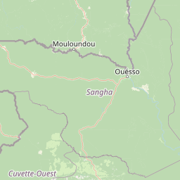
Map view of Boumba Bek National Park

Use this park location map to pinpoint Boumba Bek National Park in Cameroon, understand its exact geographic position, and read its mapped placement within the surrounding landscape more clearly.

Pigeon | © OpenStreetMap contributors

Location context for Boumba Bek National Park

East Province
Park atlas

Map the geographic spread of national parks and conservation landscapes across Cameroon and the broader TRIDOM region.

Explore Nearby National Parks and Protected Areas Around Boumba Bek National Park
Explore additional national parks and protected areas located geographically near Boumba Bek National Park, tracing the extensive lowland rainforest biome across Cameroon and the wider TRIDOM corridor. This allows for direct comparison of diverse conservation landscapes, mapping their regional spread, and understanding the broader ecological context of Central Africa's forest protected areas.
National park

Lobéké National Park National Park: A Protected Landscape within the Congo Basin

Explore its semi-evergreen forest, unique bais, and riverine ecosystems.

Lobéké National Park represents a core protected national park within the vast Congo Basin, renowned for its exceptionally high densities of African forest elephants and western lowland gorillas. Covering over 2,000 square kilometers of largely untouched semi-evergreen forest, the park features distinct ecosystems including mineral-rich bais clearings, saline swamp savannas, and diverse riverine habitats. As a crucial component of the Sangha Trinational protected area, Lobéké National Park offers a profound look into Central African wilderness and its unique natural geography.

Area
2,178 km²
Established
1999
IUCN
II
Relief
Lowland
Watercolor painting showing rolling hills, green vegetation, and a pinkish river area
National parkCentral African Republic

Dzanga-Ndoki National Park National Park: Mapped Boundaries and Geographic Context in Central Africa

Explore protected landscape geography and park atlas details.

Gain a structured understanding of Dzanga-Ndoki National Park as a protected area in the Central African Republic. This page focuses on its precise geographic scope, mapped park boundaries, and its identity as a National Park. It serves as an entry point for exploring the park's landscape context and its place within the atlas of protected natural areas, offering factual details for geographic discovery.

Area
1,143.26 km²
Established
1990
IUCN
II
Relief
Lowland
National parkCongo

Nouabalé-Ndoki National Park: Congo National Park & Protected Landscape Atlas

Explore protected area geography and mapped terrain.

Nouabalé-Ndoki National Park is a designated national park in Congo, offering rich opportunities for geographic discovery and atlas exploration. This page details the park's protected landscape, its mapped boundaries, and its significance within the regional geography of Congo. Users can investigate the park's natural terrain and its place within the broader atlas of protected areas.

Area
3,921.61 km²
Established
1993
IUCN
II
Relief
Lowland
National parkCameroon

Nki National Park: Protected National Park Landscape in Cameroon

Explore the geographic context and mapped boundaries.

Nki National Park is a designated national park in Cameroon, offering a distinct protected landscape for geographic study. This page provides essential context for understanding the park's place within the country's natural geography and protected areas atlas. Explore its mapped terrain and protected boundary details to gain a clearer picture of this natural entity within Central Africa's diverse geography.

Area
3,093 km²
Established
2005
IUCN
II
Relief
Upland
National parkCuvette-Ouest Department

Odzala-Kokoua National Park National Park: Mapped Protected Landscape in Cuvette-Ouest

Explore its geographic boundaries and regional terrain.

Odzala-Kokoua National Park is a key national park entity, offering a distinct protected landscape within the Cuvette-Ouest Department. This page provides an atlas-style exploration of its mapped boundaries and geographic context. Delve into the specifics of this protected area to understand its contribution to the regional geography and natural landscape, facilitating structured discovery of its terrain.

Area
13,500 km²
Established
1935
IUCN
II
Visitors
50 annual
National parkCongo

Ntokou-Pikounda National Park: Congo's Protected Landscape and Regional Geographic Atlas

Explore the mapped boundaries of this national park in Congo.

Ntokou-Pikounda National Park serves as a critical point of reference for understanding protected landscapes in Congo. As a national park, its geographic scope and mapped boundaries are essential for atlas-based discovery. This detailed entry facilitates an exploration of its protected terrain and regional context, highlighting its significance within the broader conservation geography.

Area
4,572 km²
Established
2012
IUCN
II
Relief
Lowland
National parkGabon

Minkébé National Park: Protected Area and Geographic Context in Gabon

Explore the mapped terrain and protected landscape of this national park.

Gain a structured understanding of Minkébé National Park, a designated national park situated in Gabon. This destination focuses on the park's protected landscape, its distinct mapped boundaries, and its contribution to the regional geography of Central Africa. Examine how its protected status shapes the natural terrain and offers a unique angle for geographic discovery.

Area
7,570 km²
Established
2002
IUCN
II
Relief
Upland
National parkGabon

Ivindo National Park: A Protected Rainforest Landscape in Gabon

Explore its waterfalls, diverse ecosystems, and mapped geographic context.

Ivindo National Park represents a significant protected landscape within Gabon, spanning a vast area of intact tropical rainforest. Recognized as a UNESCO World Heritage Site, the park is defined by the Ivindo River and its dramatic waterfalls, including the famous Kongou and Mingouli Falls. Its geography includes mountainous terrain and vital riverine ecosystems, supporting critical populations of forest elephants and great apes. This page offers a gateway to understanding the park's protected status, its unique natural features, and its role in the broader geography of Central Africa.

Area
3,000 km²
Established
2002
IUCN
II
Relief
Mixed relief

Common questions about visiting, size, designation, and location context for Boumba Bek National Park

Boumba Bek National Park FAQs for park facts, access, geography, and protected area context
Find quick answers about Boumba Bek National Park, including protected-area facts, park geography, trail and visitor context, and how the park fits into its surrounding country and regional landscape.
MoriAtlas Explorer

Continue Your Protected Areas Search Across the Global Atlas

Deepen your exploration by continuing the structured search for national parks and protected areas worldwide. Utilize the comprehensive filtering capabilities to compare different conservation landscapes and refine your understanding of global park geography. Discover more about the distribution and characteristics of protected natural areas.

Global natural geography