Mori Atlas logo
Biosphere reserveBrighton and Lewes Downs Biosphere Reserve

Tracing the chalk geology, coastal cliffs, and marine ecosystems of this unique biosphere

Brighton and Lewes Downs Biosphere Reserve: Mapped Protected Landscapes in Sussex, England

(Brighton and Lewes Downs Biosphere Reserve (now branded as The Living Coast))

The Brighton and Lewes Downs Biosphere Reserve, known as The Living Coast, spans a distinct geographic interface between the chalk hills of the South Downs and the English Channel. This protected area showcases an integrated landscape that bridges rural Sussex countryside, dramatic white chalk cliffs, and rare subtidal chalk reefs. By examining the terrestrial ridges and marine boundaries, the mapping provided here reveals the interplay between species-rich lowland grasslands, estuarine corridors, and the urban coast of Brighton and Hove.

UNESCO Biosphere Reservechalk downlandchalk cliffssubtidal chalk reeflowland chalk grasslandchalk grassland wildlife

Brighton and Lewes Downs Biosphere Reserve

Biosphere reserve

Park overview

Structured park overview, official facts, and landscape profile for Brighton and Lewes Downs Biosphere Reserve

Brighton and Lewes Downs Biosphere Reserve park facts, protected area profile, and essential visitor context

Review the core facts for Brighton and Lewes Downs Biosphere Reserve, including designation, size, terrain, visitor scale, habitats, and operating context in one park-focused overview.

About Brighton and Lewes Downs Biosphere Reserve

The Brighton and Lewes Downs Biosphere Reserve is a compact but unusually diverse protected landscape on the south coast of England. It covers a broad swathe of the Sussex countryside stretching inland from Brighton and Hove, taking in rolling chalk hills, river valleys, and a varied coastline that runs from the River Adur estuary at Shoreham-by-Sea in the west to the mouth of the River Ouse near Newhaven in the east.

At its heart lies the Brighton chalk block, a section of the South Downs defined by the underlying chalk geology. This geology shapes nearly every dimension of the reserve: it produces the gentle, open downland scenery inland, the bright white cliffs along the coast, and a rare underwater chalk reef just offshore. The reserve is therefore a place where a single underlying landscape character, chalk, expresses itself across terrestrial, freshwater, estuarine, and marine environments.

The designation also reflects the unusually varied human geography of the area. Within its boundaries are the densely populated seaside city of Brighton and Hove, several smaller Sussex towns including Lewes, Newhaven, Peacehaven, Shoreham, and Southwick, working farmland, and a stretch of coastal water used by commercial fisheries. This combination of town, countryside, and sea is central to the reserve's identity and to its UNESCO function as a place where conservation and sustainable human development are pursued together.

The reserve functions as a regional-scale demonstration area for the UNESCO Man and the Biosphere Programme, integrating ecological monitoring, public engagement, education, and economic activity within one framework. Its proximity to London, roughly 55 miles to the northwest, and its accessibility by rail and road have made it a focal point for sustainable tourism along the south coast of England.

Quick facts and research context for Brighton and Lewes Downs Biosphere Reserve

Designated as a UNESCO Biosphere Reserve in 2014 and now known as The Living Coast. The total surface area is approximately 29,514 hectares, organized into a core area of chalk downland and coastal sites, surrounded by a larger buffer zone and an urban-rural transition area.

The reserve sits between the River Adur and the River Ouse in Sussex, within and adjacent to the South Downs National Park. Governance is shared across Brighton and Hove City Council, Lewes District Council, Adur District Council, the South Downs National Park Authority, Natural England, the Sussex Inshore Fisheries and Conservation Authority, and the Marine Management Organisation, reflecting the unusually close integration of urban, rural, and marine authorities.

Protection and recognition

Documented protection scope and international recognition framework details

Brighton and Lewes Downs Biosphere Reserve Protection Status and Governance

Brighton and Lewes Downs Biosphere Reserve maintains a mixed protection scope supported by documented management records and administrative frameworks. Evaluation data outlines formal conservation parameters and international recognition standards across the protected landscape.

Protection details

Protection scope
Mixed
Transboundary protection
No
Core area
18.32 km²
Buffer area
204.79 km²
Park context

Deeper park guide and search-rich context for Brighton and Lewes Downs Biosphere Reserve

Brighton and Lewes Downs Biosphere Reserve history, landscape, wildlife, and travel context

Explore Brighton and Lewes Downs Biosphere Reserve through its history, landscape character, ecosystems, wildlife, conservation priorities, cultural context, and seasonal travel timing in a structured park guide built for atlas discovery and search intent.

Why Brighton and Lewes Downs Biosphere Reserve stands out

The reserve is especially known for its lowland chalk grassland, one of the richest temperate grassland habitats in Britain, which can support remarkable botanical diversity within a single square meter and provides a stronghold for rare invertebrates. It is equally recognized for its coastal and marine character, including high chalk cliffs, shingle beaches, river estuaries, and a discontinuous subtidal chalk reef off Brighton that has recorded biological diversity on a scale unusual for the English Channel. The blending of these habitat types with the urban environment of Brighton and Hove gives the reserve a distinctive profile as a city-adjacent UNESCO site.

Brighton and Lewes Downs Biosphere Reserve history and protected-area timeline

The Brighton and Lewes Downs Biosphere Reserve was formally designated by UNESCO in 2014, following recognition of the unique combination of chalk downland, coastline, and urban environment centered on the city of Brighton and Hove. The designation built on the area's long-standing protection through the South Downs National Park and a network of national and local nature reserves covering the downland, cliffs, and estuaries.

The reserve's conceptual roots lie in the broader history of the South Downs, where chalk grassland has been shaped by centuries of grazing and traditional land management. Heritage and archaeological evidence in the area reaches back to the Neolithic period, and the surrounding settlements, including Lewes, Shoreham, and later Brighton, developed as market towns, ports, and seaside resorts over many centuries. Modern Brighton in particular evolved from a Regency seaside resort into a major service-economy urban center, a transformation that influenced the reserve's eventual framing around sustainable urban-rural coexistence.

Following its UNESCO listing, the reserve began operating under shared governance between local councils, the South Downs National Park Authority, Natural England, and marine authorities, an arrangement designed to reflect the integrated land-and-sea nature of the site. In later years, the partnership adopted the brand name The Living Coast, providing a clearer public identity for engagement, outreach, and tourism while retaining the original UNESCO designation as its formal reference.

Brighton and Lewes Downs Biosphere Reserve landscape and geographic character

The reserve's landscape is defined above all by chalk. Inland, the terrain rises into the smooth, undulating slopes of the South Downs, where thin chalk soils support open downland cut by dry valleys and framed by the river valleys of the Adur and the Ouse. These inland downs form some of the most characteristic chalk scenery in southern England, with wide open skies, scarp and dip slopes, and long ridgeline views.

At the coast, the chalk re-emerges as a sequence of vertical white cliffs, particularly toward the eastern end of the reserve near the Ouse estuary. To the west, the shoreline becomes lower and more urbanized, transitioning into shingle beaches, the developed seafront of Brighton and Hove, and the tidal mud- and sandflats of the Adur estuary at Shoreham-by-Sea. Between these contrasting ends, the reserve includes a range of coastal forms, including vegetated shingle, estuarine margins, and small cliffs.

Beneath the waves, the same chalk geology continues offshore, where a discontinuous underwater chalk ledge west of Brighton forms low, north-facing submarine cliffs. This subtidal chalk reef is one of the rarest seabed features of the English Channel and contributes unusual structural habitat diversity to an otherwise soft-sediment coastal shelf.

Brighton and Lewes Downs Biosphere Reserve ecosystems, habitats, and plant life

Ecologically, the reserve lies within the temperate broadleaf forests biome of the Palearctic realm's British Island province, but its most distinctive biological character is expressed through chalk-dependent habitats. Lowland chalk grassland is the principal terrestrial habitat and is widely regarded as one of the richest grassland types in Britain for botanical diversity, supporting on the order of forty to fifty vascular plant species per square meter in good-quality stands.

Beyond the grassland, the reserve includes deciduous woodland on deeper soils within the downs, freshwater wetland along river valleys and emerging springs, river estuaries at the Adur and the Ouse, shingle beach vegetation along the coast, and marine habitats from intertidal chalk to subtidal reef. Together these habitats form a connected sequence from chalk upland through river valley, estuarine margin, beach, and seabed, an unusually complete chalk-land ecological gradient.

The reserve's chalk and coastal vegetation also supports specialized genetic varieties and rare breeds associated with the local landscape, including traditional Sussex elm and a heritage of wild apple tree varieties, as well as the domesticated Southdown sheep and Sussex cattle, both closely tied to the South Downs pastoral tradition.

Brighton and Lewes Downs Biosphere Reserve wildlife and species highlights

The fauna of the reserve is shaped by the same chalk-based mosaic that defines its habitats. Chalk grassland supports one of the richest invertebrate communities of any terrestrial habitat in Britain, including a notable assemblage of butterflies, with more than twenty species having substantial breeding populations within the reserve. Characteristic and locally rare species include the Adonis blue butterfly and the wart-biter, a bush-cricket strongly associated with southern chalk downland.

The cliffs and marine zones host distinctive birdlife and marine species. Northern fulmars nest on the chalk cliff faces, while the subtidal chalk reef off Brighton has been the focus of biological surveys recording over three hundred marine species. Local conservation lists include the European eel in the rivers and estuaries, alongside widespread but locally important species such as the hedgehog and the yellowhammer in the rural and fringe habitats.

The combined tally of records on international conservation lists and locally rare species lists runs into the low thousands across taxa, reflecting the conservation value of the area both as a stronghold for scarce southern chalkland species and as a refuge for more common but declining British wildlife in a heavily populated region.

Brighton and Lewes Downs Biosphere Reserve conservation status and protection priorities

The Brighton and Lewes Downs Biosphere Reserve is recognized by UNESCO for its combination of high biodiversity value and a strong cultural and economic landscape, a profile that makes it unusually relevant for demonstrating how conservation can be integrated with urban life. Its chalk grassland in particular is protected as one of the most important remaining examples of this habitat type in northern Europe, and the presence of protected core areas within the South Downs National Park and along the coast gives the reserve a robust backbone of formal protection.

Marine conservation is a distinctive element. The reserve's coverage extends offshore into the English Channel, encompassing seabed habitats including the subtidal chalk reef, and is supported in management terms through the Sussex Inshore Fisheries and Conservation Authority and the Marine Management Organisation. This integration of terrestrial and marine governance is part of what makes the reserve's conservation model distinctive.

The reserve also serves as a focal point for monitoring rare and localized species, including plants, butterflies, breeding birds, marine fauna, and traditional livestock breeds. Its role as a UNESCO site adds international reporting and review obligations, supporting long-term data collection and the sharing of conservation practice with other biosphere reserves in the United Kingdom and beyond.

Brighton and Lewes Downs Biosphere Reserve cultural meaning and human context

The cultural context of the reserve is unusually rich for a site of this size, anchored by the long sequence of human history along the South Downs and the Brighton coastline. Archaeological evidence in the area extends back to the Neolithic, and the downland and coastal edge have been continuously shaped by farming, saltmaking, fishing, and later by the growth of Brighton as a resort and then as a major coastal city.

Lewes, the historic county town of Sussex, sits within the reserve area and provides a continuous thread of market-town and administrative history, while the coastal towns of Newhaven, Peacehaven, Shoreham, and Southwick each contribute their own maritime and harbor heritage. Traditional livestock breeds, Southdown sheep and Sussex cattle, remain part of the working landscape and contribute to both agricultural heritage and habitat management through conservation grazing.

The reserve also embeds a more recent cultural layer in Brighton and Hove itself, with its Regency architecture, late-Victorian and Edwardian seaside heritage, and modern identity as a center for the arts, nightlife, and creative industries. The UNESCO designation explicitly recognizes this combination of rural, coastal, and urban heritage as part of the area's distinctive cultural character.

Top sights and standout views in Brighton and Lewes Downs Biosphere Reserve

Among the reserve's strongest points of distinction are its species-rich chalk grasslands, its sequence of chalk cliffs along the Sussex coast, and its rare subtidal chalk reef off Brighton, a combination that places chalk geology at the center of the reserve's identity from ridge to seabed.

Equally distinctive is its governance and brand: the biosphere reserve is co-managed by a partnership of local councils, the South Downs National Park Authority, and statutory conservation and marine bodies, and presents itself publicly as The Living Coast, a name designed to emphasize the integrated land-and-sea nature of the site. Its location adjacent to one of the United Kingdom's most visited seaside cities adds unusual public-engagement opportunities for a UNESCO biosphere reserve.

Best time to visit Brighton and Lewes Downs Biosphere Reserve

Late spring and early summer are typically the most rewarding times to experience the chalk downland, when lowland chalk grassland reaches peak botanical and butterfly activity and the cliff and coastal paths are most vivid. Visibility along the coast is generally best in settled spring and early summer weather, although conditions along the South Downs can change quickly.

Autumn offers quieter conditions, lower visitation from peak tourist seasons, and softer light across the downs, alongside important seasonal passage for birds along the coast and estuaries. Winter brings a quieter landscape with crisp visibility along the cliff tops and an active season for estuarine birdlife along the Adur and Ouse, though services in some parts of the reserve are reduced out of season.

Monthly climate preview

Long-term temperature and precipitation records across representative coordinate sampling

Brighton and Lewes Downs Biosphere Reserve Climate Normals and Weather by Month

Representative coordinate records show measured temperature variation from winter lows to summer highs alongside consistent daily precipitation patterns across the year. Reviewing the complete monthly climate profile provides deeper context for long-term meteorological trends across the protected landscape.
Annual mean11 °C
5 °C17 °C
Jan
Feb
Mar
Apr
May12°
Jun15°
Jul17°
Aug17°
Sep15°
Oct12°
Nov
Dec
Warmest month
August

17.2 °C

Coolest month
February

5 °C

Wettest month
November

2.9 mm/day

Driest month
March

1.6 mm/day

Park location guide

Geography guide, regional context, and park location map for Brighton and Lewes Downs Biosphere Reserve

Brighton and Lewes Downs Biosphere Reserve park geography, regions, and map view in United Kingdom

Understand where Brighton and Lewes Downs Biosphere Reserve sits in United Kingdom through a broader geographic reading of the surrounding landscape, nearby location context, and its mapped position within the national park landscape.

How Brighton and Lewes Downs Biosphere Reserve fits into United Kingdom

The United Kingdom is a parliamentary constitutional monarchy located in northwestern Europe, consisting of four constituent countries: England, Scotland, Wales, and Northern Ireland. As a major global power with over 69 million residents, it maintains significant international influence in politics, economics, and culture.

Wider geography shaping Brighton and Lewes Downs Biosphere Reserve in United Kingdom

The United Kingdom is an island nation located in northwestern Europe, surrounded by the Atlantic Ocean, North Sea, English Channel, Celtic Sea, and Irish Sea. It shares a land border with the Republic of Ireland to the west. The territory includes the island of Great Britain, the northeastern portion of Ireland, and most of the smaller British Isles islands.

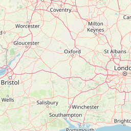
Map view of Brighton and Lewes Downs Biosphere Reserve

Use this park location map to pinpoint Brighton and Lewes Downs Biosphere Reserve in United Kingdom, understand its exact geographic position, and read its mapped placement within the surrounding landscape more clearly.

Pigeon | © OpenStreetMap contributors

Location context for Brighton and Lewes Downs Biosphere Reserve

EnglandSussex
Park atlas

Compare adjacent chalk landscapes, coastal habitats, and regional protected areas in Sussex

Parks Near Brighton and Lewes Downs Biosphere Reserve and Surrounding Protected Areas

Browsing other parks near Brighton and Lewes Downs Biosphere Reserve reveals connected chalk downland, coastal cliffs, and marine ecosystems across the surrounding region. Comparing adjacent protected areas expands geographic context for regional terrain and coastal conservation corridors.
Watercolor illustration of a coastal landscape featuring green hills, white cliffs, and a body of water
National parkSouth East England
About 0.3 km away#1 closest

West

South Downs National Park: A Distinctive Chalk Landscape in South East England's Atlas

Iconic chalk downland, coastal cliffs, and mapped terrain.

South Downs National Park is a premier protected landscape in South East England, celebrated for its unique chalk downland terrain and dramatic coastal formations. This page provides detailed geographic context for the park, highlighting its rolling hills, dry valleys, and ancient woodlands. Discover the park's mapped boundaries and its significance within England's protected areas, offering a structured atlas view for landscape exploration.

Area
1,627 km²
Established
2010
IUCN
V
Visitors
18M annual
Marine protected areaEast Sussex
About 15 km away#2 closest

Southeast

Beachy Head West Marine Protected Area: Coastal Geography and Underwater Chalk Landscapes

Mapped protected seabed and marine geography in East Sussex

Investigate the marine landscape of Beachy Head West, a protected zone defined by its submerged chalk reefs and gullies extending from the East Sussex cliffs into the English Channel. This record highlights the site's distinct underwater topography, seabed mosaic, and its role as a core component of the regional marine conservation network across southeast England.

Area
24 km²
Established
2013
Relief
Lowland
Climate
Temperate
Marine protected areaWest Sussex
About 29 km away#3 closest

Southwest

Kingmere Marine Conservation Zone: Protected Marine Geography and Chalk Reef Landscapes

Submerged chalk cliff systems and rocky reefs in West Sussex

The Kingmere Marine Conservation Zone protects an unusual underwater landscape of chalk ridges and rocky outcrops within the English Channel. Stretching between Littlehampton and Worthing, this area serves as a vital spawning ground and exhibits some of the finest chalk reef features in European waters.

Area
47 km²
Established
2013
Relief
Lowland
Climate
Temperate
Nature reserveSurrey
About 74 km away#4 closest

Northwest

Wraysbury Reservoir: An Engineered Nature Reserve and Vital Wetland Habitat in Surrey

Examining infrastructure, ecology, and sonar testing geography.

Wraysbury Reservoir stands as a unique example of late-twentieth-century industrial landscape design, serving as both a primary London water resource and a protected Ramsar wetland. Its earthen embankments enclose a specialized environment where sonar research and ecological conservation coexist within the wider context of the Thames Valley. This record details the site's boundaries, its function as a wintering bird refuge, and its specialized role in UK marine testing.

Area
2.05 km²
Established
1970
Relief
Lowland
Climate
Temperate
Watercolor painting showing a landscape with green and purple vegetation, a body of water, and distant hills.
National parkEngland
About 89 km away#5 closest

West

New Forest National Park: Historic Protected Landscape and Regional Geography in England

Mapped heathland, ancient woodlands, and pastoral traditions.

Explore New Forest National Park, a nationally significant protected area in England renowned for its unique blend of ancient royal forest history, traditional pastoral practices, and biologically rich lowland habitats. This page provides an atlas-focused view of its mapped boundaries, distinctive terrain, and geographic context within England, highlighting its value as a living landscape shaped by centuries of common grazing rights and supporting rare wildlife.

Area
566 km²
Established
2005
IUCN
V
Visitors
14.8M annual
Natural monumentIsle of Wight
About 107 km away#6 closest

West

The Needles Natural Monument: Coastal Chalk Geography and Protected Marine Landscapes

Geological formations and chalk headland terrain on the Isle of Wight

The Needles represents a unique geological intersection of vertical chalk strata and maritime history at the edge of the Isle of Wight. This protected area encompasses dramatic sea stacks, clifftop heathland, and critical marine habitats, offering a window into the complex coastal landscape of the English Channel and the regional geology of southern England.

Relief
Upland
Climate
Temperate
Access
Easy access
Scope
Mixed
Protected areaEngland
About 116 km away#7 closest

West

Dorset Heaths: Protected Lowland Landscapes and Regional Geography in Southern England

A comprehensive look at the Poole Basin heathland mosaic.

Spanning the Poole Basin, the Dorset Heaths offer a distinct geographic profile of acidic sands and diverse ecological mosaics. This protected area includes rare valley mires and coastal dunes, providing a clear window into the natural landscape history and ongoing conservation efforts within southern England's coastal regions.

Area
616.62 km²
Established
1998
Relief
Lowland
Water
Major water bodies
Nature reserveHauts-de-France
About 122 km away#8 closest

East

Réserve naturelle régionale du pré communal d'Ambleteuse: Regional Nature Reserve Geography

Coastal dune relics and protected marshland in Hauts-de-France.

This protected area provides an essential look at the coastal geography of the Opal Coast. Featuring a complex mosaic of ancient dune turf, dry heath, and wet meadows, the reserve stands as a landmark for biodiversity and traditional land management in northern France.

Area
0.605 km²
Established
1991
IUCN
IV
Relief
Lowland

Common questions about visiting, size, designation, and location context for Brighton and Lewes Downs Biosphere Reserve

Brighton and Lewes Downs Biosphere Reserve FAQs for park facts, access, geography, and protected area context

Find quick answers about Brighton and Lewes Downs Biosphere Reserve, including protected-area facts, park geography, trail and visitor context, and how the park fits into its surrounding country and regional landscape.
MoriAtlas Explorer

Continue Your Protected Areas Search Across the Global Atlas

Deepen your exploration by continuing the structured search for national parks and protected areas worldwide. Utilize the comprehensive filtering capabilities to compare different conservation landscapes and refine your understanding of global park geography. Discover more about the distribution and characteristics of protected natural areas.

Global natural geography