

Mori Atlas logo
National parkBukit Tiban National Park

Explore the mapped boundaries and regional geography of this national park in Bintulu Division.

Bukit Tiban National Park: National Park Protected Landscape and Geographic Context

Bukit Tiban National Park is a designated national park offering a unique focus for geographic discovery and atlas exploration. Located within the Bintulu Division, this protected landscape provides essential context for understanding regional natural areas and their mapped boundaries. Dive into the mapped geography to appreciate the full scope of Bukit Tiban National Park's protected identity.

BorneoSarawakTropical RainforestWildlife RefugeProtected AreaHeadwaters Protection

Bukit Tiban National Park

National park

Park overview

Structured park overview, official facts, and landscape profile for Bukit Tiban National Park

Bukit Tiban National Park park facts, protected area profile, and essential visitor context
Review the core facts for Bukit Tiban National Park, including designation, size, terrain, visitor scale, habitats, and operating context in one park-focused overview.

About Bukit Tiban National Park

Bukit Tiban National Park represents a protected pocket of Bornean forest in eastern Sarawak, a region that has experienced dramatic land-use change over recent decades. The park's establishment in 2000 reflected a recognition that remaining forest fragments in the Bintulu and Miri divisions warranted protection, both for their biodiversity value and their watershed function. The park's terrain encompasses the upper catchments of several river systems, creating an ecological gradient from the higher ridges down to valley floors. While the forest here was not immune to logging pressures prior to 1985, the area retained enough ecological integrity to merit national park designation. Today, the park exists as an island of forest within a sea of palm oil plantations, making its role as a wildlife corridor particularly vital. The surrounding landscape represents one of the most intensive agricultural conversions in Malaysian Borneo, which heightens the importance of the park as a refuge for species that cannot survive in plantation environments.

Quick facts and research context for Bukit Tiban National Park

Bukit Tiban National Park is located in Bintulu Division, Sarawak, Malaysia on the island of Borneo. The park covers 96 square kilometers and was established in 2000, designated under IUCN Category II for national park protection. It protects the headwaters of three river systems: Sungai Nyalau, Sungai Timong, and Sungai Sigrok. The area was logged before 1985 but serves as a critical wildlife refuge in a landscape otherwise dominated by palm oil cultivation.

Park context

Deeper park guide and search-rich context for Bukit Tiban National Park

Bukit Tiban National Park history, landscape, wildlife, and travel context
Explore Bukit Tiban National Park through its history, landscape character, ecosystems, wildlife, conservation priorities, cultural context, and seasonal travel timing in a structured park guide built for atlas discovery and search intent.

Why Bukit Tiban National Park stands out

Bukit Tiban National Park is best known as a remnant forest sanctuary in Sarawak's heavily plantation-modified landscape. The park serves as an important corridor and refuge for wildlife in a region where surrounding lands have been extensively converted to oil palm agriculture. Its position protecting headwater catchments gives it additional ecological significance for downstream water systems.

Bukit Tiban National Park history and protected-area timeline

Bukit Tiban National Park was formally established in 2000 as part of Malaysia's ongoing system of protected areas. The designation came during a period when Sarawak was experiencing rapid expansion of oil palm cultivation across lowland and hill areas. The park was created to protect the remaining forest in the upper catchment areas of several rivers, recognizing that headwater protection provides downstream benefits for water quality and flood regulation. Prior to its national park status, the forest within the park boundaries had been logged, though the area retained sufficient ecological value to warrant formal protection. The establishment of the park reflected a compromise between conservation objectives and the economic pressures driving land conversion in the region.

Bukit Tiban National Park landscape and geographic character

The park occupies hilly terrain in eastern Sarawak, with elevations ranging from the lower slopes up to the ridgelines that form the divides between different river catchments. The landscape is characteristic of Bornean hill forest, with steep valleys and ridges creating a varied topography. The headwaters of the Sungai Nyalau and Sungai Timong rivers originate within the park, as does the Sungai Sigrok, a tributary of the Sungai Similajau. These watercourses have carved valleys through the terrain, creating the drainage pattern that defines the park's physical geography. The forest cover, though logged in the past, provides the structural framework for the landscape's ecology.

Bukit Tiban National Park ecosystems, habitats, and plant life

The park contains tropical rainforest vegetation typical of Borneo's hill forests, though modified by earlier logging activity. The forest structure includes a mix of tree species adapted to the tropical climate and seasonal patterns of the region. The protection of headwater areas means the park also encompasses riparian zones along the stream courses that originate here. In the context of the surrounding palm oil-dominated landscape, the park functions as an ecological island, preserving habitat for species that require forest environments. The remaining forest provides canopy structure, fallen log habitat, and the microhabitats that support Borneo's distinctive biodiversity.

Bukit Tiban National Park wildlife and species highlights

Bukit Tiban National Park serves as a refuge for wildlife in a landscape where most native forest has been converted to agriculture. The park's forest habitat supports species capable of surviving in secondary forest conditions, and its function as a protected area within a fragmented landscape makes it important for maintaining wildlife populations in the region. The surrounding palm oil plantations create a matrix in which the park provides essential habitat that many species cannot utilize, making it a critical area for conservation in the Bintulu and Miri regions.

Bukit Tiban National Park conservation status and protection priorities

The conservation significance of Bukit Tiban National Park is amplified by its context within a heavily modified landscape. While the park was logged before national park establishment, its designation in 2000 created legal protection for the area and recognized its value as a wildlife corridor and watershed. The conversion of surrounding lands to palm oil plantations has created isolation for the park's wildlife populations, increasing the importance of the protected area as a refuge. Conservation value is tempered by the fact that portions of the park's eastern area have been converted to palm oil since establishment, reducing the total effective protected area. Nevertheless, the park represents a recognized commitment to maintaining forest cover in a critical part of Sarawak.

Bukit Tiban National Park cultural meaning and human context

Bukit Tiban National Park exists within the broader context of Sarawak's land-use history, where traditional forest-based livelihoods and biodiversity have increasingly given way to commercial agriculture. The park's location in the Bintulu Division places it within a region that has experienced substantial development pressure. The indigenous communities that historically used the forest resources of this area have been affected by the broader transformation of the landscape. While the park itself is managed under national park regulations, the surrounding lands reflect the economic priorities that have shaped modern Sarawak.

Top sights and standout views in Bukit Tiban National Park

Bukit Tiban National Park's primary value lies in its role as a protected forest remnant in a landscape dominated by palm oil agriculture. The park protects critical headwater catchments that feed important river systems, providing watershed benefits beyond its boundaries. Its position in eastern Sarawak places it within a biodiversity-rich region of Borneo, and the protected status offers legal framework for maintaining forest cover. The park represents one of the remaining options for forest-dependent wildlife in an area of intensive plantation development.

Best time to visit Bukit Tiban National Park

The park can be visited throughout the year given its tropical location, though the optimal period generally corresponds to the drier months typical of the region. The wet season brings increased rainfall to Sarawak, which can affect trail conditions and access within the park. The drier period typically offers more comfortable conditions for exploration, though visitors should be prepared for the ever-present humidity characteristic of Bornean forests. Planning should consider the park's remote location within Sarawak and the logistics required to reach the area from major population centers.

Park location guide

Geography guide, regional context, and park location map for Bukit Tiban National Park

Bukit Tiban National Park park geography, regions, and map view in Malaysia
Understand where Bukit Tiban National Park sits in Malaysia through a broader geographic reading of the surrounding landscape, nearby location context, and its mapped position within the national park landscape.

How Bukit Tiban National Park fits into Malaysia

Malaysia is a federal constitutional monarchy located in Southeast Asia. The country consists of 13 states and three federal territories, divided by the South China Sea into Peninsular Malaysia on the Indochinese Peninsula and East Malaysia on the island of Borneo. With a population of over 34 million, it achieved independence from Britain in 1957 and became a modern federation in 1963. The country is recognized for its multicultural population, tropical climate, and significant economic role in the region.

Wider geography shaping Bukit Tiban National Park in Malaysia

Malaysia occupies a strategic position in Southeast Asia, split by the South China Sea into two distinct regions. Peninsular Malaysia lies on the Indochinese Peninsula, sharing a land border with Thailand to the north and maritime borders with Singapore, Vietnam, and Indonesia. East Malaysia occupies the northern portion of Borneo, sharing land borders with Brunei and Indonesia, and maritime borders with the Philippines and Vietnam. The country's terrain includes coastal plains, mountain ranges such as the Titiwangsa in the peninsula, and extensive tropical rainforests.

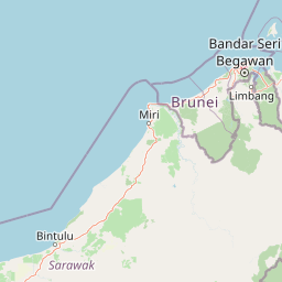
Map view of Bukit Tiban National Park

Use this park location map to pinpoint Bukit Tiban National Park in Malaysia, understand its exact geographic position, and read its mapped placement within the surrounding landscape more clearly.

Pigeon | © OpenStreetMap contributors

Location context for Bukit Tiban National Park

Bintulu DivisionSarawak
Park atlas

Compare the geographic context and conservation landscapes across Sarawak and the wider Bornean region.

Explore Other National Parks and Protected Areas Near Bukit Tiban National Park
Broaden your discovery beyond Bukit Tiban National Park by exploring other national parks and protected areas throughout Sarawak and the wider Bornean region. Compare diverse conservation landscapes, trace regional park geography, and understand the vital network of protected forest remnants, particularly headwater catchments, across this biodiverse island.
National parkBintulu Division

Similajau National Park: A Protected Landscape within Bintulu Division's Geography

Explore mapped boundaries and regional natural landscape context.

Discover Similajau National Park, a designated national park in Malaysia’s Bintulu Division. This page focuses on the park's identity as a protected landscape, providing essential geographic context for atlas-based exploration. Users can learn about the park’s mapped boundaries and its role within the regional natural geography, offering a clear understanding of its significance as a conservation area.

Area
89.96 km²
Established
1976
IUCN
II
Relief
Upland
Watercolor illustration of a landscape with green hills, trees, and a valley
National parkSarawak

Niah National Park: Sarawak's Protected National Park Geography and Mapped Landscape

Explore protected area boundaries and regional context within Sarawak

Niah National Park represents a significant protected national park, offering a distinct geographic and landscape identity within Sarawak, Malaysia. This resource facilitates the exploration of its mapped boundaries and its place within the regional atlas of Borneo. Users can delve into the specific geography of this protected area, understanding its landscape characteristics and its contribution to the broader conservation mapping of the region.

Established
1974
Relief
Mountain
Access
Moderate access
Scope
Terrestrial
National parkSarawak

Loagan Bunut National Park: Protected Landscape in Sarawak, Malaysia

Explore the mapped geography and natural terrain of this national park.

This page offers a detailed atlas-style exploration of Loagan Bunut National Park, situated in Sarawak, Malaysia. Understand the park's designation as a national park and its place within the mapped geography of Borneo. It provides essential context for appreciating the protected landscape and its regional significance.

Area
100 km²
Established
1990
IUCN
II
Scope
Terrestrial
National parkSarawak

Lambir Hills National Park: Sarawak's National Park Landscape and Geographic Discovery

Explore the mapped terrain and protected boundaries within Sarawak.

Investigate Lambir Hills National Park, a protected national park in Sarawak, Malaysia. This page provides essential geographic context and details its protected landscape identity. Understand its role within the Borneo region's atlas, offering users a deep dive into its mapped terrain and specific regional geography. Discover a key piece of Malaysia's natural protected areas with focused atlas-style information.

Area
69.52 km²
Established
1975
IUCN
II
Relief
Lowland
National parkMiri Division

Usun Apau National Park: National Park with Regional Geographic Context in Miri Division

Explore protected boundaries and mapped landscape details.

Usun Apau National Park represents a distinct protected landscape within the Miri Division, identified as a national park. This entry focuses on its geographic attributes, including its mapped boundaries and its contribution to the regional protected area network. Users can explore Usun Apau National Park to understand its specific role in the geography of Miri Division and to gain context on Malaysia's conservation landscapes.

Area
471.22 km²
Established
2005
IUCN
II
Relief
Mountain
National parkMarudi District

Gunung Mulu National Park: A Protected National Park with Distinct Geographic Identity in Marudi District

Explore its mapped protected area and regional landscape.

Gunung Mulu National Park stands as a key protected area within Marudi District, Malaysia, offering critical insights into the region's natural geography. This national park entity provides a focal point for understanding mapped protected landscapes and their specific geographic characteristics. Users can explore the park's boundaries and its role within the wider atlas of Malaysian natural areas, gaining a solid foundation in its conservation geography.

Area
528.64 km²
Established
1974
IUCN
II
Relief
Mountain
Nature reserveBrunei

Luagan Lalak Forest Recreation Park Nature Reserve: Brunei's Pristine Freshwater Swamp Landscape

Explore mapped protected-area geography and unique wetland terrain.

Luagan Lalak Forest Recreation Park, a protected nature reserve in Brunei, preserves a rare and visually distinctive freshwater swamp ecosystem. Characterized by dark, tranquil waters and vast fields of purun grass, this natural wetland offers a unique landscape context and is a prime location for observing its rich biodiversity, especially its notable birdlife. The park's preservation as an intact swamp environment within a recreational area highlights its ecological importance for regional geography and protected-area mapping.

Area
2.7 km²
Established
1980
IUCN
II
Visitors
4.2K annual
Protected areaBrunei

Tasek Merimbun Heritage Park: Protected Landscape Identity and Geographic Atlas

Mapped boundaries and regional natural context for this Brunei protected area.

Tasek Merimbun Heritage Park represents a distinct protected area within the geography of Brunei. This page provides detailed insight into its protected landscape, offering a map-centric view of its boundaries and its placement within the broader natural context of Borneo. Understand the park's geographic significance and explore its unique attributes for structured atlas exploration.

Area
78 km²
Established
1984
Climate
Tropical
Access
Easy access

Common questions about visiting, size, designation, and location context for Bukit Tiban National Park

Bukit Tiban National Park FAQs for park facts, access, geography, and protected area context
Find quick answers about Bukit Tiban National Park, including protected-area facts, park geography, trail and visitor context, and how the park fits into its surrounding country and regional landscape.
MoriAtlas Explorer

Continue Your Protected Areas Search Across the Global Atlas

Deepen your exploration by continuing the structured search for national parks and protected areas worldwide. Utilize the comprehensive filtering capabilities to compare different conservation landscapes and refine your understanding of global park geography. Discover more about the distribution and characteristics of protected natural areas.

Global natural geography
