Mori Atlas logo
National parkCălimani National Park

Discover the mapped boundaries and natural terrain of this significant national park.

Călimani National Park: Romania's Protected Landscape and Geographic Atlas

(Parcul Național Călimani)

Călimani National Park stands as a distinct protected national park within Romania, offering a unique focal point for geographic exploration and atlas-based discovery. This dedicated page provides detailed context for Călimani National Park, highlighting its role as a significant natural landscape. Engage with mapped representations of its protected boundaries and understand its position within the regional geography, all presented through the structured lens of MoriAtlas.

Volcanic landscapeEastern CarpathiansNational parkMountain forestsAlpine meadowsProtected area

Călimani National Park

National park

Park overview

Structured park overview, official facts, and landscape profile for Călimani National Park

Călimani National Park park facts, protected area profile, and essential visitor context
Review the core facts for Călimani National Park, including designation, size, terrain, visitor scale, habitats, and operating context in one park-focused overview.

About Călimani National Park

Călimani National Park preserves a substantial portion of the Călimani Mountains, a volcanic mountain range situated along the northern section of the Eastern Carpathian arc in Romania. The protected area encompasses approximately 24,000 hectares of mountainous terrain characterized by significant elevation variation and diverse landforms. The park's most remarkable geological feature is the large volcanic crater, a relic of ancient volcanic activity that has since gone extinct. This crater formation contributes significantly to the park's distinctive character and provides visual evidence of the region's volcanic origins. The terrain within the park includes numerous peaks exceeding 1,700 meters, including Pietrosul Călimanului at 2,100 meters, along with rocky cliffs, steep-sided gorges, and glacial valleys. The landscape also features dolines, sinkholes, and other karst-like formations that add to the geological complexity. Natural vegetation covers the area in a pattern of forests, pastures, and meadows that reflects both the altitude gradient and local microclimate conditions. The park was created to protect this representative sample of Carpathian mountain ecosystems while allowing for scientific research, environmental education, and sustainable tourism activities. Within its boundaries, the park includes several designated nature reserves that protect particularly significant ecological or geological features.

Quick facts and research context for Călimani National Park

Călimani National Park covers approximately 24,000 hectares of mountainous terrain in the Eastern Carpathians of Romania. The park was established in 2000 and is classified as IUCN Category II (national park). It contains Romania's largest volcanic crater, a dormant structure roughly ten kilometers in diameter. The elevation ranges from valley floors up to Pietrosul Călimanului at 2,100 meters. The park overlaps with Natura 2000 network designations as a special avifaunistic protection area. The territory is divided among four counties in northeastern Romania, with the historic sulfur mining site in the mountains now existing as an enclave within the protected area.

Park context

Deeper park guide and search-rich context for Călimani National Park

Călimani National Park history, landscape, wildlife, and travel context
Explore Călimani National Park through its history, landscape character, ecosystems, wildlife, conservation priorities, cultural context, and seasonal travel timing in a structured park guide built for atlas discovery and search intent.

Why Călimani National Park stands out

Călimani National Park is best known for containing the largest volcanic crater in Romania, a dramatic extinct volcanic structure that dominates the landscape. The park protects a representative section of Eastern Carpathian mountain ecosystems with its diverse habitat types ranging from spruce-dominated forests through subalpine meadows to mountain pine shrublands. Notable features include the Doisprezece Apostoli (Twelve Apostles) thematic trail area, the Swiss pine stand known as Jnepenișul cu Pinus cembra, and Iezer Lake. The combination of volcanic geology, high-altitude Carpathian landscapes, and biodiversity makes this park distinctive among Romania's protected areas.

Călimani National Park history and protected-area timeline

Călimani National Park was established in the year 2000 as part of Romania's expanding network of protected areas following the political changes of the late 1980s and early 1990s. The creation of the national park reflected growing recognition of the ecological and geological importance of the Călimani Mountains within the broader context of Carpathian conservation. The park's establishment came during a period when Romania was developing its modern protected area framework and integrating European conservation standards in preparation for European Union membership. The Călimani Mountains themselves have a longer human history, particularly associated with the former sulfur mining operations that once operated in the area. The former mining site now exists as an enclave within the national park boundaries, representing a period of industrial activity that preceded the area's protected status. The park now falls within the Natura 2000 network of protected sites, reflecting its importance for conservation at the European level.

Călimani National Park landscape and geographic character

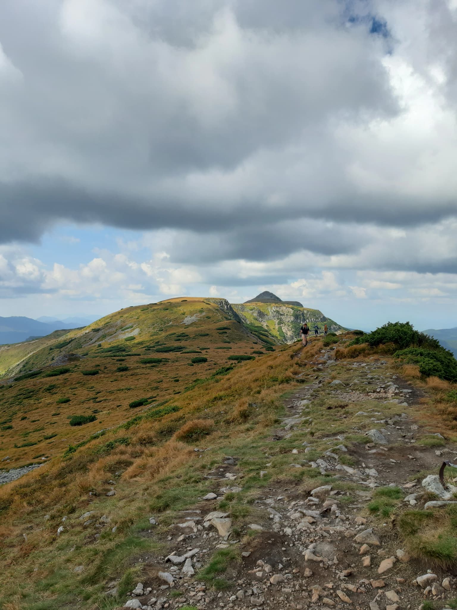
The landscape of Călimani National Park is defined by its volcanic origins and subsequent erosional processes that have shaped the Călimani Mountains over millions of years. The dominant geological feature is the large crater formation, approximately ten kilometers in diameter, which represents the remnants of a major volcanic structure that is now extinct. Around this central volcanic feature, the terrain rises into numerous peaks and ridges that form the backbone of the range. The highest point within the park is Pietrosul Călimanului at 2,100 meters, with other notable peaks including Gurghiu at 1,776 meters, Harghita at 1,800 meters, Lucaciu at 1,778 meters, the Twelve Apostles peaks at 1,760 meters, and Ciomatu at 1,301 meters. The park contains diverse terrain features including rocky steep cliffs, narrow gorges, U-shaped glacial valleys, dolines, and undulating hillock terrain. The combination of volcanic bedrock and glacial modification has created a landscape of considerable visual diversity, with exposed rock faces contrasting with forested slopes and open meadows. The presence of both cliff formations and gentle alpine meadows provides ecological and scenic variety within a single protected area.

Călimani National Park ecosystems, habitats, and plant life

The ecological character of Călimani National Park reflects its position within the Eastern Carpathians, a mountain range known for its biodiversity and habitat complexity. The park contains multiple distinct habitat types that support a range of species assemblages characteristic of Carpathian mountain environments. The forests are dominated by Norway spruce in the montane zone, with patches of larch and Swiss pine occurring at higher elevations and on specific substrate types. The subalpine zone features mountain pine and Rhododendron shrub communities that form dense vegetation cover on exposed slopes. Alpine meadows occur above the tree line, featuring species-rich grassland communities adapted to the harsh mountain conditions. The park also includes riparian vegetation along mountain streams and rivers. Several of these habitat types are of European conservation significance, including the acidophilous spruce forests of the mountain region, larch and Swiss pine communities, siliceous mountain meadows, and subarctic willow formations. This habitat diversity supports the park's inclusion within the Natura 2000 network as a special avifaunistic protection area, indicating its importance for bird species conservation at the European level.

Călimani National Park wildlife and species highlights

Călimani National Park provides protected habitat for numerous species associated with Carpathian mountain ecosystems. The diverse habitats from forest through subalpine zones to open meadows support a range of wildlife communities. The spruce forests provide habitat for forest-dwelling species, while the meadow and shrubland areas support different ecological guilds. The park's designation as a Natura 2000 site specifically for avifauna indicates particular significance for bird species, with the protected area playing a role in conserving bird populations of European importance. The presence of multiple habitat types at varying elevations creates conditions that support species diversity across taxonomic groups. The relatively intact nature of the protected area, combined with its size and connectivity within the broader Carpathian mountain system, contributes to its value as wildlife habitat.

Călimani National Park conservation status and protection priorities

Călimani National Park serves as an important conservation node within the Carpathian mountain ecosystem of Romania. The protected area preserves representative examples of Eastern Carpathian mountain habitats including forest types, alpine meadows, and volcanic landscape features. The park's inclusion in the Natura 2000 European Union ecological network reflects its conservation significance at the continental scale, particularly for bird species. The designation as a Special Avifaunistic Protection Area (SPA) establishes legal protections for bird species that depend on the park's habitats. The park also contains several designated nature reserves that provide enhanced protection for particularly significant features: the Doisprezece Apostoli area with its thematic trail, the Swiss pine forest stand, and Iezer Lake. These reserves function as core conservation zones within the broader park boundary. The presence of the former mining enclave within the park also represents an opportunity for environmental restoration of previously impacted lands.

Călimani National Park cultural meaning and human context

The Călimani Mountains have historical connections to human activity through mineral extraction, particularly sulfur mining that occurred in the area prior to the establishment of the protected area. The former mining operation has left a physical imprint on the landscape that now exists as an enclave within the national park boundaries. This historical use represents the primary human context for the area, though the park itself does not contain extensive documentation of traditional cultural practices or long-term indigenous land use. The region's broader cultural context relates to the communities of northeastern Romania who have historically utilized the mountain resources, though the national park designation has established different relationship between local populations and the landscape.

Top sights and standout views in Călimani National Park

Călimani National Park preserves Romania's most significant volcanic crater formation within a protected mountain landscape. The extinct volcano with its approximately ten-kilometer diameter crater provides a dramatic geological showcase that distinguishes this park from other Romanian protected areas. The diversity of habitats from spruce forests through Swiss pine communities to alpine meadows creates ecological richness across a compact mountain terrain. The presence of the Twelve Apostles peak formation and thematic trail offers a distinctive visitor experience, while Iezer Lake provides a water feature within the high mountain environment. The park's multi-county location and accessibility from Vatra Dornei make it a reachable destination for those exploring the Carpathians. The Natura 2000 designation underlines the European-level conservation importance of this Eastern Carpathian mountain preserve.

Best time to visit Călimani National Park

The optimal visiting period for Călimani National Park extends from late spring through early autumn, when weather conditions in the mountain environment are most favorable for outdoor exploration. Summer months offer the warmest conditions and longest daylight hours, making them particularly suitable for hiking and trail exploration across the various elevation zones within the park. The summer season brings meadows into full flower and provides the most accessible conditions for experiencing the park's landscapes. Autumn brings changing foliage colors through the forested areas and typically clear visibility that can offer excellent views from the higher peaks. Spring and early summer correspond with higher water levels in streams and may provide different landscape characteristics as snowmelt feeds the mountain drainage systems. Winter visitation is possible but requires appropriate equipment and awareness of the challenges that snowy and icy conditions present in this high-altitude mountain environment.

Park location guide

Geography guide, regional context, and park location map for Călimani National Park

Călimani National Park park geography, regions, and map view in Romania
Understand where Călimani National Park sits in Romania through a broader geographic reading of the surrounding landscape, nearby location context, and its mapped position within the national park landscape.

How Călimani National Park fits into Romania

Romania is a unitary semi-presidential republic located in Southeast and Central Europe. It borders Ukraine, Hungary, Serbia, Bulgaria, Moldova, and the Black Sea. The country has a population of approximately 19 million and covers an area of 238,397 km². Bucharest is the capital and largest city. Romania joined the European Union in 2007.

Wider geography shaping Călimani National Park in Romania

Romania lies on the lower course of the Danube River, north of the Balkan Peninsula, and on the northwestern shore of the Black Sea. The terrain is varied, featuring the Carpathian Mountains in the center, the Transylvanian Plateau, the Moldavian Plateau, and plains along the Danube and in the south. The country has a diverse landscape that includes forests, meadows, and wetland areas.

Map view of Călimani National Park

Use this park location map to pinpoint Călimani National Park in Romania, understand its exact geographic position, and read its mapped placement within the surrounding landscape more clearly.

Pigeon | © OpenStreetMap contributors

Location context for Călimani National Park

Bistrița-Năsăud CountyHarghita CountyMureș CountySuceava County
Park atlas

Compare Romania's diverse protected areas, tracing their mapped geography and unique conservation landscapes throughout the Eastern Carpathian range.

Explore Nearby National Parks and Protected Areas Around Călimani National Park, Romania
Continue your exploration beyond Călimani National Park by discovering other national parks and protected areas within Romania's Eastern Carpathian mountain range. This geographic view offers an essential atlas perspective for comparing unique volcanic landscapes, mountain forests, and alpine ecosystems across the wider region.
Protected landscapeMureș County

Defileul Mureșului Superior Natural Park: Protected Landscape Mapping and Geography

Explore Mureș County's premier protected landscape.

Access detailed mapping and geographic context for Defileul Mureșului Superior Natural Park. As a protected landscape situated in Romania's Mureș County, this entity offers crucial insights into regional natural terrain and protected area distribution. Explore its mapped boundaries and understand its significance within the broader atlas of protected lands.

Area
91.56 km²
Established
2007
IUCN
V
Relief
Mixed relief
National park

Rodna Mountains National Park: Explore Protected Landscape and Geographic Atlas

Discover the mapped terrain and protected area context.

Rodna Mountains National Park represents a key protected landscape within Romania, offering rich opportunities for geographic discovery. This page provides detailed insight into its mapped boundaries and how it integrates into the regional terrain. Delve into the structured atlas data to understand the park's protected area status and its significance within the natural geography.

Relief
Mountain
Scope
Terrestrial
National park

Cheile Bicazului-Hășmaș National Park: Protected Area Geography and Mapped Landscape Identity

Discover Romania's National Park mapped boundaries and regional context.

Cheile Bicazului-Hășmaș National Park represents a vital component of Romania's protected natural areas, offering rich geographic detail for atlas enthusiasts. This national park's mapped landscape and defined protected boundaries provide essential context for understanding regional geography and conservation efforts. Explore the specific identity of this protected terrain and its significance within the broader Romanian atlas.

Area
65.75 km²
Relief
Mountain
Scope
Mixed
Water
Minor water
Protected landscapeNeamț County

Vânători-Neamț Natural Park: Protected Landscape within Neamț County, Romania

Mapped protected area and regional landscape context.

Vânători-Neamț Natural Park is a designated protected landscape located in Romania's Neamț County. This MoriAtlas entry provides detailed geographic information, focusing on the park's mapped boundaries and its role within the regional atlas of protected natural areas. Understand the park's specific landscape context and its place within the wider geography of Western Moldavia, essential for any structured exploration of Romanian protected lands.

Area
306.31 km²
Established
2003
IUCN
V
Scope
Terrestrial
Watercolor illustration of a mountainous landscape with rolling hills, a river, and green vegetation
Protected landscapeMaramureș County

Maramureș Mountains Natural Park: Protected Landscape and Carpathian Geography

Explore the mapped boundaries and dramatic terrain of Romania's largest nature park.

Delve into the Maramureș Mountains Natural Park, a protected landscape covering extensive tracts of the northern Carpathian Mountains. This page provides detailed geographic context, showcasing the park's mapped boundaries, diverse alpine terrain, and its role within the broader regional geography of Maramureș County. Understand the natural features and protected area significance of this expansive Carpathian wilderness for structured atlas exploration.

Area
1,488.5 km²
Established
2004
IUCN
V
Relief
Mountain
Watercolor illustration of a mountainous landscape with forests, a lake, and distant peaks.
National parkChernivtsi Oblast

Cheremosh National Nature Park: Protected Landscape and Geographic Context in UA

Explore mapped boundaries within Chernivtsi Oblast

Cheremosh National Nature Park represents a vital protected area within Ukraine's Chernivtsi Oblast. This entry offers a structured exploration of the park's geographic identity, focusing on its mapped boundaries and its significance as part of the regional natural landscape. Delve into the terrain and understand how Cheremosh National Nature Park contributes to the mapped geography of western Ukraine, providing a foundation for atlas-based discovery.

Area
71 km²
Established
2009
IUCN
II
Relief
Mountain
National parkChernivtsi Oblast

Vyzhnytsia National Nature Park: Protected National Park Landscape Exploration

Mapped boundaries and regional terrain in Chernivtsi Oblast.

Delve into the specific protected landscape of Vyzhnytsia National Nature Park, a designated national park in Ukraine's Chernivtsi Oblast. This detailed entry provides context on its geographic positioning, mapped natural features, and the surrounding regional terrain, aiding in structured atlas exploration and understanding its significance within the protected areas network.

Area
7,928.4 km²
Established
1995
IUCN
II
Relief
Mountain
National parkVerkhovyna Raion

Verkhovyna National Nature Park: Explore Protected Landscape Geography in Verkhovyna Raion

Discover Ukraine's Verkhovyna National Nature Park mapped terrain.

Verkhovyna National Nature Park represents a vital protected area within the Verkhovyna Raion of Ukraine. This detailed atlas entry focuses on the park's geographic significance, providing insights into its mapped boundaries and its role within the regional landscape context of the Carpathian Mountains. It serves as a focused point for understanding the park's protected status and its place in a structured geographic discovery framework.

Area
120 km²
Established
2010
IUCN
II
Relief
Mountain

Common questions about visiting, size, designation, and location context for Călimani National Park

Călimani National Park FAQs for park facts, access, geography, and protected area context
Find quick answers about Călimani National Park, including protected-area facts, park geography, trail and visitor context, and how the park fits into its surrounding country and regional landscape.
MoriAtlas Explorer

Continue Your Protected Areas Search Across the Global Atlas

Deepen your exploration by continuing the structured search for national parks and protected areas worldwide. Utilize the comprehensive filtering capabilities to compare different conservation landscapes and refine your understanding of global park geography. Discover more about the distribution and characteristics of protected natural areas.

Global natural geography