
Viewpoints
Park geography
A detailed assessment of land area, environmental classifications, and regional distribution
Cát Tiên National Park Geographic Profile: Administrative Regions and Terrain Landscapes
The geographic profile for Cát Tiên National Park in Vietnam provides a structured look at its 720 square kilometer landscape. This analysis documents the core regional span across Đồng Nai, Bình Phước, and Lâm Đồng provinces while characterizing the tropical forest, wetland, and riverine terrain found throughout the territory.

Vietnam's largest lowland tropical forest reserve with exceptional biodiversity
Cát Tiên National Park
Cát Tiên National Park is a sprawling protected area in southern Vietnam, spanning approximately 720 square kilometers across Đồng Nai, Bình Phước, and Lâm Đồng provinces. Located roughly 150 kilometers north of Ho Chi Minh City, it represents one of the largest remaining tracts of lowland tropical forest in Vietnam. The park encompasses diverse ecosystems including primary evergreen forest, extensive bamboo woodlands, seasonally flooded grasslands, and wetlands centered around the famous Bàu Sấu (Crocodile Lake). Established in its current form in 1998 through the merger of three previously separate protected sectors, Cát Tiên holds significant ecological importance as a habitat for numerous endangered species and serves as a critical component of the Đồng Nai Biosphere Reserve, designated by UNESCO in 2011.
- Location
- Vietnam
- Park type
- National park
- Established
- 1992
- Area
- 720 km²
Location overview
Regional placement within Đồng Nai, Bình Phước, and Lâm Đồng
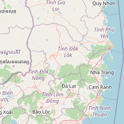
Geographic Position and Regional Setting of Cát Tiên National Park
Cát Tiên National Park spans Vietnam and American Samoa, touching Đồng Nai, Bình Phước, and Lâm Đồng provinces. The terrestrial reserve is recorded as an inland, non-transboundary sanctuary with no marine or coastal zones.
- Countries
- Vietnam
- Regions
- Bình Phước Province, Đồng Nai Province, Lâm Đồng Province
- Primary location
- Vietnam
- Geographic setting
- Inland
Boundary and coordinates
Examining the 720 square kilometer footprint and spatial coordinates
Boundary Mapping and Geographic Extent of Cát Tiên National Park
Map boundaries outline the protective reach of Cát Tiên National Park across the region. Geomatics datasets provide estimates of the 720 square kilometer area alongside coordinate spans and center points.
- Boundary area
- 712.9 km²
- Boundary perimeter
- 299.8 km
- Northernmost point
- 11.8039° N
- Southernmost point
- 11.3471° N
- Easternmost point
- 107.558° E
- Westernmost point
- 107.1633° E
- Geographic centre
- 11.5587° N, 107.3418° E
- North–south span
- 50.5 km
- East–west span
- 43 km
Terrain and natural features
Explore recorded lowland terrain classes and internal natural landmarks
Cát Tiên National Park Terrain and Named Natural Features
Cát Tiên National Park encompasses stored lowland terrain classifications alongside various recorded natural features located within the protected boundary. Individual feature cards detail names, designated types, measurements, and spatial relationships where documented.
Selected named natural features
Peaks
Núi Đang Mun Mung
232 m
Reservoirs
Hồ Phước Trung
Lakes
Bàu Sấu
Viewpoints
Grasslands observation tower (west)
Rivers
Suối Đạ Lây
Environmental setting
Tropical lowland forest, riverine wetlands, and seasonal water systems
Cát Tiên National Park Environmental Setting and Habitat Classification
Stored classifications provide complementary perspectives on the physical setting and habitat types of the protected area. Recorded categories connect directly to related atlas destinations for broader regional geography.
- Relief
- Lowland
- Climate
- Tropical
- Water
- Major water bodies
- Forest cover
- Mostly forested
- Seasonality
- Seasonal
Landscape features
Forest · Grassland · Wetland · Marsh · Lakes · Rivers · Woodland
Habitat types
Tropical forest · Grassland · Riverine habitat · Wetland · Lacustrine habitat
Park atlas
Trace the geographic spread of Vietnam's protected areas, exploring adjacent landscapes for comparison.
Compare Nearby National Parks and Protected Areas Surrounding Cát Tiên National Park
From Cát Tiên National Park, continue your exploration by browsing nearby national parks and other protected areas across Vietnam's diverse geographic regions. This provides crucial regional context, allowing you to trace the spread of conservation landscapes and compare specific park characteristics for a comprehensive atlas-style understanding.
National parkĐắk Nông Province
About 42 km away#1 closest
Northeast

Tà Đùng National Park: Protected Landscape and Geographic Atlas Entry
Mapped Boundaries and Regional Terrain Context
Tà Đùng National Park represents a vital protected landscape within Vietnam's Đắk Nông Province, offering rich opportunities for geographic discovery. This entry details the park's identity as a national park, focusing on its mapped boundaries and its contribution to the regional atlas. Explore the fundamental geographic features and protected land context that define Tà Đùng National Park, facilitating a deeper understanding of its place within the broader natural landscape.
- Area
- 209 km²
- Established
- 2018
- IUCN
- II
- Relief
- Mountain
National parkBình Phước Province
About 55 km away#2 closest
North
Bù Gia Mập National Park: Protected Landscape and Regional Geography in Vietnam
Discover its mapped boundaries and terrain in Bình Phước Province.
Bù Gia Mập National Park is a designated national park in Vietnam, located within the geographical area historically associated with Bình Phước Province. This page focuses on providing a structured understanding of the park's protected land status and its mapped geographic features. Explore the context of this protected landscape, its position within the regional geography, and its role as an element for atlas-based discovery of Vietnam's natural areas.
- Area
- 260.32 km²
- Established
- 2002
- IUCN
- II
- Relief
- Upland
National parkLâm Đồng Province
92 km away#3 closest
Northeast
Bidoup Nui Ba National Park: Vietnam National Park Atlas and Protected Landscape
Explore mapped boundaries and regional geography of this protected area.
Bidoup Nui Ba National Park is a prominent national park located within the Lâm Đồng Province of Vietnam's Central Highlands. This park serves as a focal point for understanding the regional geography and the distribution of protected lands across Vietnam. Its mapped boundaries define a significant natural landscape, offering users detailed atlas-style context for geographic exploration and protected-area research.
- Area
- 648 km²
- Established
- 2004
- IUCN
- II
- Relief
- Mountain
National parkĐắk Lắk Province
106 km away#4 closest
North
Yok Đôn National Park: Vietnam's Expansive Lowland Forest Protected Landscape and Regional Geography
Mapped boundaries within Đắk Lắk Province, part of a transboundary conservation area.
Yok Đôn National Park is Vietnam's largest lowland forest national park, covering approximately 1,155 square kilometers in Đắk Lắk Province. This protected area is characterized by its rare khộp forest ecosystem and serves as a crucial refuge for large mammals. Situated near the Cambodian border, it forms a key component of one of Southeast Asia's largest continuous protected area networks, offering significant insights into regional protected landscape geography and conservation connectivity.
- Area
- 1,155.45 km²
- Established
- 1986
- IUCN
- II
- Relief
- Lowland
National parkTây Ninh Province
About 127 km away#5 closest
West
Lò Gò, Xa Mát National Park: Exploring Protected Landscape Boundaries and Regional Geography
Vietnam National Park Mapped Terrain and Atlas Context
Discover Lò Gò, Xa Mát National Park, a vital protected area situated in Tây Ninh Province. This entry focuses on its role as a national park, providing key insights into its mapped boundaries and contribution to the regional geography. Understand its landscape context as part of a broader atlas of protected lands, offering a factual basis for geographic discovery and conservation area research.
- Area
- 300.22 km²
- Established
- 2002
- IUCN
- II
- Relief
- Lowland
National parkNinh Thuận Province
About 135 km away#6 closest
East
Phước Bình National Park: Protected Area Identity and Geographic Setting in Ninh Thuận
Explore Vietnam's Phước Bình National Park and its mapped terrain.
Phước Bình National Park represents a distinct national park entity situated within Ninh Thuận Province, Vietnam. This destination facilitates an atlas-driven understanding of its protected landscape, emphasizing its geographical placement and mapped boundaries. Explore the core identity of this park as a component of Vietnam's protected areas network and its specific regional landscape context.
- Area
- 198.14 km²
- Established
- 2006
- IUCN
- II
- Relief
- Mountain

National parkĐắk Lắk Province
About 155 km away#7 closest
Northeast
Chư Yang Sin National Park: Mapped Protected Landscape in Đắk Lắk Province
Explore its protected boundaries and regional geographic context.
Chư Yang Sin National Park stands as a key protected natural area within Vietnam's Central Highlands. This national park, located in the expansive Đắk Lắk Province, provides a rich subject for geographic discovery. Understanding its mapped boundaries and position within the regional landscape offers valuable context for atlas-based exploration of Vietnam's protected lands.
- Area
- 589.47 km²
- Established
- 2002
- IUCN
- II
- Scope
- Terrestrial
National parkNinh Thuận Province
164 km away#8 closest
East
Núi Chúa National Park: Protected Landscape and Geographic Atlas Entry
Explore Ninh Thuận Province's national park geography.
Núi Chúa National Park is a key protected area within Vietnam's Ninh Thuận Province, offering vital context for understanding regional geography and mapped natural landscapes. This entry provides the essential geographic details for the park, serving as a foundational element for atlas-based discovery of Vietnam's protected lands. Delve into its mapped boundaries and landscape identity to appreciate its significance.
- Area
- 317.05 km²
- Established
- 2003
- IUCN
- II
- Relief
- Mountain
MoriAtlas Explorer
Continue Exploring Cát Tiên National Park's Geography and Protected Landscape
Delve deeper into the specific protected landscape and regional geography of Cát Tiên National Park. Understanding its mapped terrain and its place within Vietnam's natural heritage provides a richer atlas perspective. This national park's unique wetland and forest ecosystems offer a compelling focus for structured geographic discovery beyond its basic details.
Browse next
Global natural geography
Explore related park routes
Explore MoriAtlas Global ParksBrowse All MoriAtlas ParksGlobal Park Map DiscoveryMoriAtlas: Browse All CountriesBrowse All MoriAtlas ContinentsNational Park Environment AtlasGrand Canyon National Park AtlasYellowstone National Park AtlasYosemite National Park Atlas and GeographySerengeti National Park AtlasGalápagos National Park Protected LandscapeBanff National Park Geography and AtlasKruger National Park Atlas EntryUluṟu-Kata Tjuṯa National Park AtlasExplore Uluru-Kata Tjuta National Park GeographyPlitvice Lakes National Park AtlasFiordland National Park Protected LandscapeGreat Smoky Mountains National Park AtlasAfghanistan National Parks and Protected AreasAlbania National Parks and Protected AreasAlgeria National Parks and Protected AreasAmerican Samoa National Parks and Protected AreasAndorra National Parks and Protected AreasAngola National Parks and Protected AreasAntarctica National Parks and Protected AreasAntigua and Barbuda Park List