Mori Atlas logo
National parkChichibu-Tama-Kai National Park

Discover the mapped terrain and regional context of this protected national park in Saitama Prefecture.

Chichibu-Tama-Kai National Park: A National Park Detailed Geographic & Protected Landscape Atlas

Chichibu-Tama-Kai National Park stands as a significant protected national park, offering a rich tapestry of natural landscapes within Saitama Prefecture. This page serves as your detailed atlas entry, focusing on the park's mapped boundaries, its place in regional geography, and its overall protected land identity. Understand the intrinsic geographic context and the unique landscape character that defines Chichibu-Tama-Kai National Park for structured exploration.

Alpine MountainsSacred SitesDeep GorgesJapanese National ParksHiking TrailsHistoric Routes

Chichibu-Tama-Kai National Park

National park

Park overview

Structured park overview, official facts, and landscape profile for Chichibu-Tama-Kai National Park

Chichibu-Tama-Kai National Park park facts, protected area profile, and essential visitor context
Review the core facts for Chichibu-Tama-Kai National Park, including designation, size, terrain, visitor scale, habitats, and operating context in one park-focused overview.

About Chichibu-Tama-Kai National Park

Chichibu-Tama-Kai National Park occupies a unique position in Japan's protected area system as a park that bridges multiple prefectures and geographic regions, creating a continuous wilderness corridor at the doorstep of Tokyo. The park's core consists of the Oku-Chichibu mountain range, a compact but spectacular alpine zone where steep-sided valleys, ridgelines, and peaks rise dramatically from the surrounding lowlands. This geography creates diverse microclimates and habitats within a relatively contained area, supporting both subalpine and montane ecosystems. The park's cultural landscape reflects centuries of human interaction with this mountain environment, from sacred mountain worship practices that predate written history to the development of mountain trails and waystation villages along historic highways. Unlike parks that preserve wilderness in relative isolation, Chichibu-Tama-Kai remains intimately connected to surrounding communities, with villages, hot spring resorts, and small towns along its periphery providing access points and visitor services. The park's three visitor centers at Mitake, Okutama, and Yama-no-furusato help orient visitors to the park's multiple personalities, from the shrine-studded peaks of the Tokyo side to the deep gorges and remote summits of the Yamanashi and Nagano sections. The park's multi-prefectural administration reflects both its ecological continuity and the historical connections that have tied these mountain communities together across regional boundaries.

Quick facts and research context for Chichibu-Tama-Kai National Park

Chichibu-Tama-Kai National Park spans approximately 1,216 square kilometers across Saitama, Yamanashi, Nagano, and Tokyo Prefectures in central Honshū. The park was established on July 10, 1950, originally named Chichibu Tama National Park before being renamed in 2000 to incorporate the name of Yamanashi Prefecture. The highest peak is Mount Kobushi at 2,475 meters, one of eight summits exceeding 2,000 meters within the Oku-Chichibu range. The park serves as a critical watershed, source, or tributary for four major river systems. Three visitor centers provide environmental education and trail information. The park holds IUCN Category II protected area status.

Park context

Deeper park guide and search-rich context for Chichibu-Tama-Kai National Park

Chichibu-Tama-Kai National Park history, landscape, wildlife, and travel context
Explore Chichibu-Tama-Kai National Park through its history, landscape character, ecosystems, wildlife, conservation priorities, cultural context, and seasonal travel timing in a structured park guide built for atlas discovery and search intent.

Why Chichibu-Tama-Kai National Park stands out

Chichibu-Tama-Kai National Park is best known for its dual identity as both a sacred mountain landscape and an accessible alpine wilderness. The ancient shrines of Mount Mitake and Mount Mitsumine, each dating back nearly 2,000 years, represent some of Japan's oldest continuous religious sites. The park's network of deep gorges and dramatic peaks includes celebrated destinations such as Mitake Shosēn Gorge, with its granite formations ranked among Japan's top 100 waterways, and the mountain summits featured in the Hyakumeizan (100 Famous Mountains) climbing tradition. The area also preserves sections of historic routes including the Kōshū Kaidō, providing a tangible connection to Edo-period travel and pilgrimage culture.

Chichibu-Tama-Kai National Park history and protected-area timeline

Chichibu-Tama-Kai National Park was designated on July 10, 1950, as one of Japan's earliest post-war national parks, emerging from the country's broader conservation movement that sought to protect iconic natural landscapes. Originally named simply Chichibu Tama National Park, the park initially excluded reference to Yamanashi Prefecture despite that prefecture containing the largest share of the park's territory. In 2000, following sustained advocacy from Yamanashi Prefecture, the official name was changed to Chichibu-Tama-Kai National Park to reflect the full geographic scope and to honor the Kai Province historical name associated with Yamanashi. The establishment of special protection zones and core visitor use plans followed in 1955, creating the framework for balancing conservation with public access. The park's history of human settlement predates its protected status by millennia, with Mount Mitake's Musashi-Mitake Shrine dating to approximately 90 B.C. during the reign of Emperor Sujin, making it one of Japan's oldest documented religious sites. This tradition of sacred mountain worship created an early framework for environmental stewardship that influenced the region's character long before formal protection began.

Chichibu-Tama-Kai National Park landscape and geographic character

The landscape of Chichibu-Tama-Kai National Park is defined by the Oku-Chichibu mountain range, a cluster of steep, rocky peaks and deep valleys that form a compact but dramatic alpine environment at the transition between Japan's Kantō and Chūbu regions. The eight peaks exceeding 2,000 meters include Mount Kobushi (2,475m), Mount Daibosatsu (2,057m), and Mount Kinpusan, creating a landscape of jagged ridgelines, rocky summits, and forested slopes. Between these peaks, the terrain drops into deep river-cut gorges such as the Nishizawa Canyon, Nakatsu Canyon, and the celebrated Mitake Shosēn Gorge, where granite boulders sculpted by centuries of water flow create dramatic scenery. The park's rivers descend through these valleys from their highland sources, feeding systems including the Arakawa, which flows through Saitama Prefecture, the Chikuma River system that becomes the Shinano River in Nagano, the Tama River serving Tokyo, and the Fuefuki River draining into the Fuji River basin in Yamanashi. Elevation changes from around 2,500 meters at the highest summits down into valley floors create dramatic visual contrasts between alpine rock and steep forest slopes.

Chichibu-Tama-Kai National Park ecosystems, habitats, and plant life

The nature of Chichibu-Tama-Kai reflects the ecological transition between Japan's central mountain ecosystems and the influences of both Pacific and Sea of Japan climate patterns. The park's forests are dominated by coniferous species typical of Japan's montane zones, including sections of old-growth forest that retain ecological character from pre-industrial times. The valleys and gorge environments support distinct riparian communities along clear streams, while the high ridges and summits host alpine vegetation communities adapted to harsh conditions. The Japanese beech (Fagus japonica) forest on Mount Mito represents a particularly notable habitat, recognized among Japan's finest examples of this species and designated as one of the country's top 100 mountains in 1997. The park's position at the watershed divide between multiple river systems enhances its ecological significance as a continuous green corridor connecting different watersheds and supporting species movement across the mountain landscape.

Chichibu-Tama-Kai National Park wildlife and species highlights

Chichibu-Tama-Kai National Park supports diverse wildlife populations across its elevation gradients and habitat types, from riparian species in the valley floors to alpine specialists on the high peaks. The gorges and surrounding forests provide habitat for numerous bird species, with the Mitake Shosōn Gorge specifically noted for significant bird populations. The park's streams support native fish and aquatic communities adapted to the clear, cold waters descending from the mountains. While the English source provides limited specific wildlife detail, the diverse habitats created by the park's elevation range and forest types suggest a full complement of Japan's central mountain fauna, including various mammal species typical of these latitudes.

Chichibu-Tama-Kai National Park conservation status and protection priorities

Chichibu-Tama-Kai National Park represents an important conservation designation protecting a critical mountain ecosystem at the heart of Japan's most populous region. The park's watershed protection function extends beyond its boundaries, with the rivers originating within its borders serving millions of downstream residents in the Tokyo metropolitan area and surrounding prefectures. The designation of IUCN Category II status reflects the park's dual function in protecting both natural values and opportunities for compatible public use. The park's designation in 1950 made it one of Japan's earliest national parks, and the continued investment in visitor infrastructure including the three visitor centers demonstrates the long-term commitment to balancing conservation with public engagement. The preservation of ancient forest sections and the protection of key habitats within the park contribute to broader biodiversity conservation goals in Japan's mountain ecosystems.

Chichibu-Tama-Kai National Park cultural meaning and human context

The cultural landscape of Chichibu-Tama-Kai National Park is inseparable from its natural terrain, with the mountains having served as sites of religious significance for over two millennia. Mount Mitake's Musashi-Mitake Shrine, established during Emperor Sujin's reign around 90 B.C., represents one of Japan's oldest documented Shinto establishments and continues active worship practices today, with a cable car providing visitor access to this sacred site. Mount Mitsumine similarly hosts the Mitsumine Shrine at its summit, marking another ancient mountain worship center. Beyond these formal religious sites, the park preserves elements of historic travel infrastructure including the Tochimoto Sekisho checkpoint along the Chichibu Trail, which connected the historic Kōshū Kaidō highway serving Edo-period travel between Musashi and Kai Provinces. The Daibosatsu Pass gained literary fame through Kaizan Nakazato's novel The Sword of Doom, adding cultural dimension to the physical landscape. The park's multi-prefectural extent reflects historical regional boundaries while creating a shared conservation identity across what were once separate domains.

Top sights and standout views in Chichibu-Tama-Kai National Park

The highlights of Chichibu-Tama-Kai span both natural and cultural dimensions, beginning with the sacred peaks of Mount Mitake and Mount Mitsumine where ancient shrines have drawn pilgrims for centuries. The Mitake Shosōn Gorge stands out for its granite rock formations and ranked status among Japan's top waterways. The park's eight peaks exceeding 2,000 meters offer diverse hiking experiences, while the deep canyons of Nishizawa and Nakatsu provide scenic valley exploration. Mount Mito's Japanese beech forest represents a distinctive botanical highlight recognized among Japan's finest. The historic Oume Route and Kōshū Kaidō remnants preserve the park's role as an historic transportation corridor. From the Tokyo side, the accessible peaks and shrines provide entry points for visitors seeking spiritual and natural experiences together, while the more remote Yamanashi and Nagano sections offer wilderness solitude.

Best time to visit Chichibu-Tama-Kai National Park

Chichibu-Tama-Kai National Park can be enjoyed throughout the year, with each season offering distinct experiences suited to different visitor interests. Spring and early summer bring pleasant temperatures for hiking as the mountains green, with June featuring the famous azalea blooms around Mōkiba in the Nagano section. Summer offers warm conditions at lower elevations and cool refuge on the peaks, though the season coincides with Japan's rainy period in early summer. Autumn is particularly celebrated throughout the park, with November providing spectacular fall foliage in the canyons including Nakatsu Canyon and the Nishizawa Valley, while October brings autumn color to higher elevations and the Daibosatsu Pass area. Winter transforms the high peaks into a different landscape, with snow cover and reduced access creating a more austere mountain experience suited to winter hiking or contemplation from the valley floors. The visitor centers remain operational year-round, though some trail sections and cable car services may have seasonal schedules affecting access to specific destinations.
Park location guide

Geography guide, regional context, and park location map for Chichibu-Tama-Kai National Park

Chichibu-Tama-Kai National Park park geography, regions, and map view in Japan
Understand where Chichibu-Tama-Kai National Park sits in Japan through a broader geographic reading of the surrounding landscape, nearby location context, and its mapped position within the national park landscape.

How Chichibu-Tama-Kai National Park fits into Japan

Japan is an island nation in East Asia comprising over 14,000 islands in the Pacific Ocean. The country operates as a unitary parliamentary constitutional monarchy with Emperor Naruhito as the reigning monarch and Prime Minister Sanae Takaichi leading the government. With a population of approximately 123 million, Japan is the world's 11th most populous country and a major economic power with one of the strongest militaries, though it has constitutionally renounced its right to declare war.

Wider geography shaping Chichibu-Tama-Kai National Park in Japan

Japan is an island nation in the Pacific Ocean, bordered to the west by the Sea of Japan and extending from the Sea of Okhotsk in the north to the East China Sea in the south. The Japanese archipelago lies off the northeast coast of the Asian mainland. Approximately 75% of Japan's terrain is mountainous and heavily forested, with agricultural land and urbanized populations concentrated along the eastern coastal plains. The country is divided into 47 administrative prefectures and eight traditional regions.

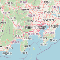
Map view of Chichibu-Tama-Kai National Park

Use this park location map to pinpoint Chichibu-Tama-Kai National Park in Japan, understand its exact geographic position, and read its mapped placement within the surrounding landscape more clearly.

Pigeon | © OpenStreetMap contributors

Location context for Chichibu-Tama-Kai National Park

ChūbuKantōNagano PrefectureSaitama PrefectureTokyoYamanashi Prefecture
Park atlas

Browse Japan's diverse mountain ranges, deep gorges, and sacred sites within the surrounding Kantō and Chūbu regions.

Explore More National Parks and Protected Areas Near Chichibu-Tama-Kai National Park
Continue your exploration from Chichibu-Tama-Kai National Park by browsing other national parks and protected areas across Japan's central alpine landscapes and historic regions. Compare diverse conservation sites, trace connected mountain ranges, and understand the regional spread of protected geography after examining Chichibu-Tama-Kai's unique features.
Watercolor painting of green and pink mountain ranges with forested foreground and distant peaks.
National parkChūbu region

Minami Alps National Park: A Protected Alpine Wilderness in Japan's Chūbu Region

Discover its dramatic peaks and vital river headwaters.

Minami Alps National Park offers a profound exploration into Japan's high-altitude natural geography. As a national park, it preserves a dramatic alpine environment defined by glacially carved terrain and multiple peaks exceeding 3000 meters. This protected landscape serves as a vital watershed, safeguarding the origins of major river systems and showcasing a rugged mountain character distinct from more accessible areas, ideal for understanding protected wildlands.

Area
357.52 km²
Established
1964
IUCN
II
Relief
Mountain
National parkJapan

Jōshin'etsu-kōgen National Park: Protected Landscape and Regional Geography Atlas

Explore the mapped boundaries and geographic identity of this national park.

Jōshin'etsu-kōgen National Park represents a vital protected area within Japan, offering rich opportunities for geographic discovery through its mapped landscape. This entry provides detailed context on its protected boundaries and its relation to the surrounding regional geography, perfect for atlas-based exploration of natural terrains and conservation landscapes. Understand the unique geographic setting of this important national park.

Area
1,481.94 km²
Established
1949
IUCN
II
Relief
Mountain
National parkJapan

Myōkō-Togakushi Renzan National Park: Mapped Protected Landscape Geography in Japan

Explore the park's regional terrain and protected area context.

Delve into the geographic specificities of Myōkō-Togakushi Renzan National Park, a key protected landscape in Japan. This entry focuses on its mapped terrain, regional setting, and the atlas-value of understanding its protected boundaries. Gain clarity on the park's distinct natural geography and its contribution to the broader protected area network.

Area
397.72 km²
Established
2015
IUCN
II
Relief
Mountain
National parkKantō region

Oze National Park National Park: A Key Protected Landscape in the Kantō Region

Explore its mapped geography and protected area context.

Oze National Park is a designated national park in Japan's Kantō region, offering a prime example of a protected landscape. This page provides detailed insights into its geographic setting and mapped boundaries, contributing to a structured understanding of regional natural terrain. Users can delve into the park's specific identity as a conservation area and its significance within the broader atlas of Japanese geography and protected lands.

Area
372.22 km²
Established
2007
IUCN
V
Relief
Mixed relief
National parkTochigi Prefecture

Nikkō National Park: Discover its Protected Landscape and Regional Geography

Explore mapped boundaries and natural terrain within Tochigi Prefecture.

Understand Nikkō National Park as a key protected area within the geography of Tochigi Prefecture. This dedicated page provides an atlas-style overview of its natural landscape, mapped contours, and significance. Users can gain insights into the park's protected status and its placement within Japan's diverse natural regions, fostering a deeper appreciation for its geographic context.

Area
1,149.08 km²
Established
1934
IUCN
II
Relief
Mountain
National parkJapan

Fuji-Hakone-Izu National Park: Japan's Premier National Park with Diverse Volcanic Landscapes and Mapped Geography

Explore volcanic terrain, hot springs, islands, and Mount Fuji's iconic protected boundaries.

Fuji-Hakone-Izu National Park is a vast and diverse protected area in Japan, anchored by the iconic Mount Fuji. This national park features a remarkable range of volcanic landscapes, including natural hot springs, rugged coastlines, and the unique Izu Islands extending into the Pacific. Delve into its mapped geography and protected landscape identity for a comprehensive atlas-style understanding of this significant natural asset within Japan.

Area
1,227 km²
Established
1936
IUCN
II
Visitors
11.3M annual
Watercolor illustration of a mountain landscape with a lake, grasses, and flowers
National parkIshikawa Prefecture

Hakusan National Park: Sacred Mountain Protected Landscape in Ishikawa Prefecture

Mapped alpine terrain and volcanic geography for protected area discovery.

Hakusan National Park offers a unique exploration of Japan's sacred mountain heritage and alpine natural beauty. This protected landscape, centered on Mount Haku, features distinct volcanic terrain, crater lakes, and exceptional alpine flora. Users can explore the park's mapped boundaries, understand its place within Ishikawa Prefecture's geography, and appreciate its role as a significant UNESCO Biosphere Reserve for detailed atlas-based discovery.

Area
477 km²
Established
1962
IUCN
II
Relief
Mountain
National parkTōhoku region

Bandai-Asahi National Park: National Park Exploration and Geographic Context

Explore protected landscapes and mapped terrain in Japan's Tōhoku region.

Bandai-Asahi National Park provides critical insights into Japan's protected natural areas and regional geography. As a designated national park, it serves as a key entity for understanding mapped boundaries and landscape characteristics within the Tōhoku region. This page is designed for detailed atlas exploration, offering a focused view on the park's geography and its significance as a protected landscape.

Area
1,870.41 km²
Established
1950
IUCN
II
Visitors
7.1M annual

Common questions about visiting, size, designation, and location context for Chichibu-Tama-Kai National Park

Chichibu-Tama-Kai National Park FAQs for park facts, access, geography, and protected area context
Find quick answers about Chichibu-Tama-Kai National Park, including protected-area facts, park geography, trail and visitor context, and how the park fits into its surrounding country and regional landscape.
MoriAtlas Explorer

Continue Your Protected Areas Search Across the Global Atlas

Deepen your exploration by continuing the structured search for national parks and protected areas worldwide. Utilize the comprehensive filtering capabilities to compare different conservation landscapes and refine your understanding of global park geography. Discover more about the distribution and characteristics of protected natural areas.

Global natural geography