

Mori Atlas logo
National parkChinji National Park

Explore the distinctive eroded terrain and semi-arid geography of the Salt Range.

Chinji National Park: National Park Atlas and Protected Landscape in Punjab, Pakistan

Chinji National Park stands as a protected national park within Pakistan's Punjab province, offering a distinct glimpse into the geological and ecological character of the Salt Range. This region features deeply eroded sandstone and igneous formations, carved by torrential streams that feed into the Soan River corridor. The park's semi-arid landscape, classified within the Baluchistan xeric woodlands, preserves unique biodiversity and the geological heritage of this geologically significant area.

National ParkProtected AreaSalt RangeSemi-Arid LandscapePunjab PakistanXeric Shrublands

Chinji National Park

National park

Park overview

Structured park overview, official facts, and landscape profile for Chinji National Park

Chinji National Park park facts, protected area profile, and essential visitor context

Review the core facts for Chinji National Park, including designation, size, terrain, visitor scale, habitats, and operating context in one park-focused overview.

About Chinji National Park

Chinji National Park occupies a distinctive position in Pakistan's protected area network as a conservation unit preserving the semi-mountainous terrain of the Salt Range in central Punjab. The park was established in 1987 through the Wildlife and Parks Department of the Government of Punjab, representing a commitment to protecting the unique ecological character of this region. The terrain consists of deeply eroded landscapes where sandstone gives way to igneous rock formations, interspersed with deposits of rock salt that have been historically extracted from the Salt Range. The drainage system is characterized by deep torrential streams and ravines that carry seasonal runoff into the Soan River, which flows through the park and provides critical water resources for the broader landscape. The park's elevation of approximately 680 meters places it in a transitional zone between the fertile plains of central Punjab and the higher mountainous terrain to the north. This geographic position, combined with the region's semi-arid climate, has shaped a distinctive ecosystem that supports both desert-adapted species and species more typically associated with forested environments. The accessibility of the park from Islamabad, approximately 130 kilometers away, has made it a destination for environmental education and research, though visitor numbers remain modest at 2,000 to 5,000 annually, reflecting the park's focus on conservation rather than mass tourism.

Quick facts and research context for Chinji National Park

Chinji National Park covers 6,095 hectares in District Talagang, Punjab, Pakistan. Established in 1987, it lies on the Sargodha road near Chinji town at an elevation of 680 meters. The park features deeply eroded sandstone and igneous terrain with rock salt deposits from the Salt Range, traversed by ravines feeding into the Soan River. The area receives approximately 537mm of annual rainfall, with a monsoon season from July to September. Winter temperatures can drop to 2.2°C with frequent frost, while summer highs reach 27°C. The park is managed by the Wildlife and Parks Department of the Government of Punjab and receives between 2,000 and 5,000 visitors annually.

Protection and recognition

Mapping the official conservation boundaries and terrestrial designation established in 1987

Documented Protection Status and Terrestrial Designation of Chinji National Park

Geographic researchers can trace the established conservation framework of Chinji National Park, a protected terrestrial zone designated in 1987. Analyzing these documented protection metrics offers essential regional context for understanding resource management and land classification within the larger Pakistani landscape.

Protection details

Protection scope
Terrestrial
Designated year
1987
Transboundary protection
No
Park context

Deeper park guide and search-rich context for Chinji National Park

Chinji National Park history, landscape, wildlife, and travel context

Explore Chinji National Park through its history, landscape character, ecosystems, wildlife, conservation priorities, cultural context, and seasonal travel timing in a structured park guide built for atlas discovery and search intent.

Why Chinji National Park stands out

Chinji National Park is best known for its location in the historic Salt Range, a region of significant geological importance in central Pakistan. The park protects a semi-arid mountain ecosystem characterized by eroded sandstone and igneous terrain with visible rock salt deposits. It represents one of the few protected areas preserving the Baluchistan xeric woodlands ecoregion, hosting populations of notable species including the Punjab urial, Indian wolf, Bengal fox, and Indian pangolin. The park's position along the Soan River corridor and its proximity to Islamabad make it an accessible conservation area for understanding the ecological transition between Punjab's plains and the mountainous northern regions.

Chinji National Park history and protected-area timeline

Chinji National Park was established in 1987 as part of Pakistan's expanding network of protected areas during the late twentieth century. The creation of the park reflected growing recognition of the ecological significance of the Salt Range region, which had historically been valued primarily for its mineral resources rather than its biodiversity. The selection of the Chinji area for protection acknowledged both the unique geological character of the terrain and the wildlife populations that had persisted despite human activity in the surrounding landscape. The park was designated under IUCN Category II, recognizing its primary purpose as national park protection rather than strict nature reserve management. Management responsibility was assigned to the Wildlife and Parks Department of the Government of Punjab, which continues to oversee conservation activities, boundary enforcement, and visitor management. The establishment period coincided with broader environmental policy developments in Pakistan, including the formulation of national conservation strategies and increased attention to protected area expansion. While the park does not carry the historical significance of some older protected areas in Pakistan, its creation represents a specific institutional response to the ecological values of this particular geographic region.

Chinji National Park landscape and geographic character

The landscape of Chinji National Park is defined by its location within the Salt Range, a prominent geological formation that extends across central Punjab and contains significant deposits of rock salt and other minerals. The terrain consists of deeply eroded landforms where weathering has created a complex pattern of ridges, ravines, and seasonal drainage channels. The underlying geology transitions from sedimentary sandstone to igneous rock formations, with small deposits of rock salt visible in certain areas, reflecting the region's name and historical significance as a source of salt extraction. The topography slopes downward toward the Soan River, which passes through the park and serves as the primary drainage outlet for the surrounding catchment area. Deep torrential streams have carved ravines into the landscape, creating seasonal watercourses that carry monsoon rainfall and spring snowmelt from higher elevations. The combination of semi-arid climate, eroded terrain, and the presence of the Soan River has produced a landscape of considerable visual and geological interest, characterized by barren slopes, scattered vegetation in drainage corridors, and the distinctive pale coloration of salt-affected soils.

Chinji National Park ecosystems, habitats, and plant life

The natural environment of Chinji National Park represents the Baluchistan xeric woodlands ecoregion, a biome characterized by desert and xeric shrubland conditions. The park supports subtropical vegetation adapted to the region's semi-arid climate, with plant species that can withstand extended dry periods and seasonal moisture variation. The average annual rainfall of 537 millimeters, with over half falling during the monsoon season from July to September, creates pronounced wet and dry seasons that shape vegetation patterns. Maximum temperatures reach 27°C in June while minimum temperatures drop to 2.2°C in January, with frost being common during the winter months. The humidity can reach 80% during the monsoon period, providing temporary relief to the generally xeric conditions. This ecological setting produces a vegetation community dominated by drought-resistant shrubs and small trees, with more dense vegetation concentrated along drainage corridors and near water sources. The park's position within a transitional zone between different ecological regions contributes to its botanical diversity, as species from both desert and more temperate environments can be found within its boundaries.

Chinji National Park wildlife and species highlights

Chinji National Park supports a diverse collection of wildlife species adapted to the semi-arid conditions of the Salt Range region. The mammal population includes several species of conservation interest, most notably the Punjab urial, a subspecies of the urial sheep that is native to the northwestern regions of the Indian subcontinent. Predators present in the park include the Indian wolf, Bengal fox, and golden jackal, which prey on the various small mammals and ungulates found in the area. The Indian pangolin, a scaly anteater species, is among the notable mammals recorded within the park boundaries. The small mammal community includes Brandt's hedgehog, Indian long-eared hedgehog, Asian house shrew, Indian bush rat, and various other species. The bird community is particularly diverse, with game birds such as the grey francolin and chukar partridge being characteristic species. Raptors including black-winged kite and black kite are regularly observed, while water-associated species such as black-winged stilt, Eurasian teal, and common pochard utilize seasonal water bodies. The reptile community includes the Bengal monitor, yellow-belly gecko, and oriental garden lizard, representing the reptilian fauna adapted to the region's warm climate.

Chinji National Park conservation status and protection priorities

Chinji National Park serves as an important conservation unit within Pakistan's protected area network, preserving a sample of the Baluchistan xeric woodlands ecoregion that would otherwise face significant pressure from human development. The park's designation as IUCN Category II reflects its primary function of protecting natural ecosystems while allowing for limited sustainable use. The Salt Range region has experienced historical human activity through salt mining and agricultural expansion, making protected status essential for maintaining ecological processes and wildlife populations. The park provides critical habitat for the Punjab urial, a subspecies of conservation concern, as well as for the Indian wolf and Indian pangolin, both of which face population pressures across their ranges. The protection of the Soan River corridor within the park boundaries contributes to broader watershed conservation in the region. The modest visitor numbers of 2,000 to 5,000 annually indicate a management approach that prioritizes conservation outcomes over tourism development, allowing the ecosystem to maintain relatively natural processes while providing educational opportunities for visitors interested in understanding this distinctive environmental setting.

Chinji National Park cultural meaning and human context

Chinji National Park exists within a cultural landscape shaped by the historical significance of the Salt Range, which has been an important source of rock salt for centuries and gave the region its name. The town of Chinji, located near the park boundary, serves as a local center for the surrounding agricultural community. The broader District Talagang has been inhabited for centuries, with traditional land use patterns that included pastoral activities and small-scale agriculture. The establishment of the park in 1987 created a new institutional presence in the landscape, introducing conservation management alongside existing human activities. The Salt Range holds historical importance beyond its mineral resources, as the area has been traversed by travelers and traders moving between the Punjab plains and the mountainous territories to the north. While the park itself does not contain designated cultural heritage sites of major significance, the surrounding landscape carries the imprint of human activity extending back through multiple generations of local communities.

Top sights and standout views in Chinji National Park

Chinji National Park offers visitors the opportunity to experience the distinctive semi-mountainous terrain of the Salt Range, with its eroded sandstone formations and visible rock salt deposits creating a landscape unlike the more commonly visited mountainous parks of northern Pakistan. The park provides accessible wildlife observation opportunities, with species such as Punjab urial, Indian wolf, and various small mammals being potentially observable during careful exploration. The Soan River corridor adds hydrological and ecological interest to the park, particularly during the monsoon season when water flows through the drainage channels. The park's proximity to Islamabad makes it a feasible destination for day trips or short excursions, while the modest visitor pressure ensures that the natural environment remains relatively undisturbed. The combination of geological features, wildlife populations, and the semi-arid ecological character makes Chinji a useful park for understanding the environmental diversity of Punjab province beyond its famous agricultural plains.

Best time to visit Chinji National Park

The optimal time to visit Chinji National Park depends on visitor preferences, with different seasons offering distinct experiences. The winter months from November through February provide comfortable temperatures for exploration, though nighttime temperatures can drop significantly and frost is common. This period offers the advantage of clear skies and the opportunity to observe wildlife at water sources when natural water availability is reduced elsewhere. The pre-monsoon spring season from March through May sees warming temperatures but maintains relatively dry conditions, making it suitable for hiking and landscape observation. The monsoon season from July to September brings increased rainfall, transforming the drainage channels and producing seasonal waterfalls and pools, though high humidity and sudden downpours can complicate travel. The park can be visited year-round, though the extreme summer heat in June, when temperatures reach 27°C, may be uncomfortable for extended outdoor activities. Visitors interested in wildlife observation should consider the dry season when animals concentrate near water sources, while those interested in landscape photography may find the post-monsoon period particularly rewarding as vegetation greens the terrain.
Monthly climate preview

Monthly temperature and precipitation profiles across the Punjab reserve terrain

Long-Term Average Climate and Weather by Month in Chinji National Park

Climatological records for Chinji National Park reveal a stark annual cycle, marked by mid-year maximums over 46 degrees Celsius and near-freezing lows during cold months. Accessing the complete monthly profile provides detailed metrics on average daily precipitation, temperature fluctuations, and climate trends.
Annual mean24 °C
11 °C35 °C
Jan11°
Feb13°
Mar19°
Apr25°
May32°
Jun35°
Jul34°
Aug32°
Sep29°
Oct24°
Nov18°
Dec13°
Warmest month
June

35.2 °C

Coolest month
January

10.8 °C

Wettest month
July

4.7 mm/day

Driest month
November

0.4 mm/day

Park location guide

Geography guide, regional context, and park location map for Chinji National Park

Chinji National Park park geography, regions, and map view in Pakistan

Understand where Chinji National Park sits in Pakistan through a broader geographic reading of the surrounding landscape, nearby location context, and its mapped position within the national park landscape.

How Chinji National Park fits into Pakistan

Pakistan, officially the Islamic Republic of Pakistan, is a federal parliamentary Islamic republic in South Asia. It is the fifth-most populous country and the 33rd-largest by area. The country gained independence from British India in 1947 and has a diverse history spanning ancient civilizations including Mehrgarh and the Indus Valley Civilisation. Pakistan shares maritime borders with Oman and is bounded by the Arabian Sea, Gulf of Oman, and several neighboring countries.

Wider geography shaping Chinji National Park in Pakistan

Pakistan is located in South Asia, bordered by the Arabian Sea to the south, the Gulf of Oman to the southwest, and shares land borders with India to the east, Afghanistan to the west, Iran to the southwest, and China to the northeast. The country also shares a maritime border with Oman in the Gulf of Oman. The Wakhan Corridor in Afghanistan separates Pakistan from Tajikistan in the northwest.

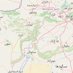
Map view of Chinji National Park

Use this park location map to pinpoint Chinji National Park in Pakistan, understand its exact geographic position, and read its mapped placement within the surrounding landscape more clearly.

Pigeon | © OpenStreetMap contributors

Location context for Chinji National Park

Punjab
Park atlas

Trace the mapped geography of protected areas surrounding Chinji, comparing landscapes across Punjab province.

Discover Other National Parks and Protected Areas Near Chinji National Park, Pakistan

Explore additional national parks and protected areas located within Pakistan's Punjab province and the wider Salt Range region, offering diverse landscapes from xeric shrublands to eroded mountain terrain. Comparing nearby conservation areas to Chinji National Park provides valuable geographic context for understanding the varied natural heritage and ecological transitions across central Pakistan.
Wildlife reservePunjab
About 41 km away#1 closest

South

Chumbi Surla Wildlife Sanctuary: Geographic Overview of Punjab Foothill Habitats

Mapping protected scrub forests and ridges in Khushab and Chakwal

Covering thousands of acres of contiguous reserve forest, Chumbi Surla Wildlife Sanctuary represents a crucial protected ecosystem within the Punjab landscape. This high-altitude scrub environment provides an essential refuge for the Punjab urial, characterized by deep valleys, stony slopes, and ridge systems that define the topography of the local Salt Range outliers.

Area
226.4 km²
Established
1978
IUCN
IV
Relief
Upland
National parkPakistan
About 47 km away#2 closest

Southeast

Salt Range National Park: Pakistan's Protected Landscape for Geographic Atlas Exploration

Mapped boundaries and regional terrain context for a Pakistani national park.

Gain insight into Salt Range National Park, a significant national park established within Pakistan. This entry focuses on its role as a protected landscape, providing a mapped view of its geographic scope and environmental context. Understand how this park contributes to Pakistan's broader geography and offers opportunities for atlas-based discovery of its natural terrain.

Relief
Mountain
Scope
Terrestrial
National parkPunjab
About 58 km away#3 closest

Northeast

Kheri Murat National Park: Protected Scrub Forest and Wildlife Conservation in Punjab

Explore the mapped terrain and protected landscape context.

Discover Kheri Murat National Park, a recent national park designation located in Punjab, Pakistan, situated on the rolling hills of the Kala Chitta Range. This protected area features a distinct subtropical thorn scrub forest ecosystem, providing essential habitat for wildlife, including the Punjab urial, and serving as a critical site for bird conservation. Its unique landscape offers valuable insights into regional geography and the preservation of natural wilderness within a predominantly agricultural province, making it a noteworthy entity for atlas exploration.

Area
35.37 km²
Established
2020
IUCN
II
Relief
Mountain
Protected areaKhushab District
About 63 km away#4 closest

Southwest

Uchhali Complex Protected Area: Geography, Salt Range Lakes, and Wetland Mapping

Key protected wetland landscape in the Soon Valley of Punjab

The Uchhali Complex serves as a critical wetland system characterized by the brackish and saline waters of Khabikki, Uchhali, and Jahlar lakes. Situated in the Soon Valley, this protected area offers a unique geographic perspective on the interplay between the mineralized geology of the Salt Range and the surrounding semi-arid terrain. This detail overview examines the site as a landmark habitat for migratory waterbirds and a defining feature of the Khushab District landscape.

Area
12.43 km²
Established
1996
Access
Access unknown
Scope
Terrestrial
National parkJhelum District
About 69 km away#5 closest

Southeast

Tilla Reserve National Park: Mapped Protected Landscape and Dry Forest Ecosystem

Explore the geography and ancient heritage of this Salt Range national park.

Tilla Reserve National Park is a protected area recognized for its significant dry subtropical forest ecosystems and rich cultural history within Pakistan's Salt Range. Situated in Jhelum District, the park's landscape is characterized by steep, rocky ridges and ancient geological formations. Discover its unique mapped terrain, the distribution of its remnant forest habitats, and its importance as a protected natural and spiritual site.

Area
40.6 km²
Established
2021
IUCN
II
Relief
Mountain
National parkAttock District
About 75 km away#6 closest

North

Kala Chitta National Park: Protected Dry Temperate Forest in Attock District, Pakistan

Discover unique hill landscapes and a rare ecosystem on the Pothohar Plateau.

Kala Chitta National Park represents a crucial protected area in Punjab, Pakistan, safeguarding a distinct dry temperate forest ecosystem that is uncommon in the Pothohar Plateau's heavily agricultural landscape. The park's terrain comprises rolling hills and intervening plains, contributing to its ecological richness and providing valuable mapped landscape context. Explore the geographic importance of this national park and its role in preserving a vital natural habitat.

Area
363.77 km²
Established
1983
IUCN
II
Relief
Mixed relief
National parkIslamabad Capital Territory
About 89 km away#7 closest

Northeast

Margalla Hills National Park: Pakistan's Gateway to Himalayan Foothills Geography

Mapped protected landscape with rich Sino-Himalayan biodiversity.

Margalla Hills National Park, situated in the Islamabad Capital Territory, serves as Pakistan's most accessible national park and a vital entry point to the Himalayan foothills. This protected landscape is defined by its rugged mountain terrain, ranging from lower scrublands to higher pine and oak woodlands, with elevations up to 1,604 meters. The park's geological significance, with ancient marine fossil formations, adds a unique dimension to its natural identity. Discover the mapped boundaries and ecological richness that characterize this important protected area, offering insights into regional geography and diverse habitats.

Area
173.86 km²
Established
1980
IUCN
V
Relief
Mountain
National parkKhyber Pakhtunkhwa
About 112 km away#8 closest

Northeast

Ayubia National Park: Protected Area Identity and Mountainous Terrain

Discover its mapped geography within Khyber Pakhtunkhwa

Ayubia National Park stands as a key protected landscape within the Himalayan foothills of Khyber Pakhtunkhwa, Pakistan. Its designation as a national park signifies its role in conserving unique temperate coniferous and mixed forests across steep mountainous terrain. This page details the park's geographic setting, its mapped boundaries, and the natural features that define its protected status, offering a structured view for atlas-driven exploration of Pakistan's natural heritage.

Area
33.12 km²
Established
1984
IUCN
V
Visitors
250K annual

Common questions about visiting, size, designation, and location context for Chinji National Park

Chinji National Park FAQs for park facts, access, geography, and protected area context

Find quick answers about Chinji National Park, including protected-area facts, park geography, trail and visitor context, and how the park fits into its surrounding country and regional landscape.
MoriAtlas Explorer

Continue Your Protected Areas Search Across the Global Atlas

Deepen your exploration by continuing the structured search for national parks and protected areas worldwide. Utilize the comprehensive filtering capabilities to compare different conservation landscapes and refine your understanding of global park geography. Discover more about the distribution and characteristics of protected natural areas.

Global natural geography