Mori Atlas logo
State or regional parkCopeland Tops State Conservation Area

Tracing the mapped terrain of rare dry rainforest pockets, towering eucalypt forests, and gold mining heritage.

Copeland Tops State Conservation Area: A Protected Landscape in the Hunter Region of New South Wales

Copeland Tops State Conservation Area encompasses 2,201 hectares of forested landscape situated in the foothills near the Barrington Tops plateau in New South Wales. This protected conservation reserve serves as a vital transition zone, where extensive wet sclerophyll eucalyptus forests meet pockets of dry subtropical rainforest. Beyond its biological significance, the reserve preserves nineteenth century industrial history through the remnants of the Mountain Maid gold mine, which remains integrated into the surrounding undulating forest terrain.

wet sclerophyll forestdry rainforestsubtropical fernsepiphytic fernsmoss and lichen forestmarsupial habitat

Copeland Tops State Conservation Area

State or regional park

Park overview

Structured park overview, official facts, and landscape profile for Copeland Tops State Conservation Area

Copeland Tops State Conservation Area park facts, protected area profile, and essential visitor context

Review the core facts for Copeland Tops State Conservation Area, including designation, size, terrain, visitor scale, habitats, and operating context in one park-focused overview.

About Copeland Tops State Conservation Area

Copeland Tops State Conservation Area occupies a forested tract on the foothills that connect Gloucester to the higher ranges of the Barrington Tops in New South Wales, Australia. Covering around 2,201 hectares, it functions as a transition zone between the agricultural lands of the Gloucester valley and the cooler montane forests and plateaus of the broader Barrington wilderness. Its position on the eastern edge of the Barrington range gives it a wet, sheltered climate that supports unusually tall stands of both eucalyptus and subtropical rainforest species.

The conservation area was formally gazetted on 1 July 2003 and is managed by the NSW National Parks and Wildlife Service as a state conservation area, a category that recognises landscapes with significant natural values while accommodating some low-impact public use and ongoing access to cultural heritage features. Unlike a strict nature reserve, the park retains interpretive opportunities around its nineteenth century mining history, balancing active conservation with the protection of culturally significant sites.

What makes Copeland Tops genuinely distinctive within the NSW protected area estate is the close juxtaposition of wet sclerophyll eucalyptus forest with a dry rainforest community. The rainforest pockets host large specimens of shatterwood, black booyong, Moreton Bay fig, and white cedar, and some red cedar trees exceed forty metres in height. The canopy of these patches is further enriched by epiphytic ferns, including the large, nest-forming bird's nest ferns as well as staghorn and elkhorn ferns, giving parts of the reserve a humid, subtropical feel unusual for an inland Hunter Region locality.

Equally important to the park's identity is its gold mining heritage. Gold was discovered here by timber collectors in 1875, and by 1878 the local population had grown to roughly one thousand people. Most mining activity ended by 1890, but the abandoned workings, most notably the Mountain Maid mine, remain as tangible reminders of the area's brief but intense mining era. These old shafts have found a new ecological role, providing daytime roosting habitat for microbats. The combination of rainforest, tall eucalypt forest, mining heritage, and rich marsupial fauna gives Copeland Tops a layered identity that rewards both visitors interested in natural values and those drawn to the region's industrial past.

Quick facts and research context for Copeland Tops State Conservation Area

Copeland Tops is a New South Wales state conservation area covering about 2,201 hectares in the Hunter Region, roughly 12 kilometres west of Gloucester and adjacent to the Barrington Tops. It was formally established as a conservation area on 1 July 2003 and is managed by the NSW National Parks and Wildlife Service. The protected landscape is dominated by wet sclerophyll eucalyptus forest interspersed with dry rainforest, and it preserves relics of the 1870s Mountain Maid gold rush, including mine workings that now shelter microbats.

Protection and recognition

Terrestrial conservation framework and official recognition records

Copeland Tops State Conservation Area Protection Status and Formal Designation Facts

Copeland Tops State Conservation Area maintains a documented terrestrial protection scope within the regional conservation network. Structured management records outline formal designation boundaries and baseline administrative data.

Protection details

Protection scope
Terrestrial
Park context

Deeper park guide and search-rich context for Copeland Tops State Conservation Area

Copeland Tops State Conservation Area history, landscape, wildlife, and travel context

Explore Copeland Tops State Conservation Area through its history, landscape character, ecosystems, wildlife, conservation priorities, cultural context, and seasonal travel timing in a structured park guide built for atlas discovery and search intent.

Why Copeland Tops State Conservation Area stands out

Copeland Tops is best known for its unusual pairing of wet sclerophyll eucalyptus forest with a dry rainforest community that contains very tall red cedar, massive Moreton Bay figs, and impressive epiphytic ferns such as bird's nest, staghorn, and elkhorn ferns. The area is also recognised for the surviving relics of the Mountain Maid gold mine, a late nineteenth century operation that briefly supported a population of around one thousand people. The reserve draws additional attention for its abundant marsupial fauna, including koalas, eastern grey kangaroos, red-necked wallabies, wombats, and greater gliders, alongside microbats that roost in the abandoned gold mine shafts. Together, these rainforest pockets, tall forest tiers, and industrial-era relics give the park a character that distinguishes it from neighbouring Barrington Tops reserves.
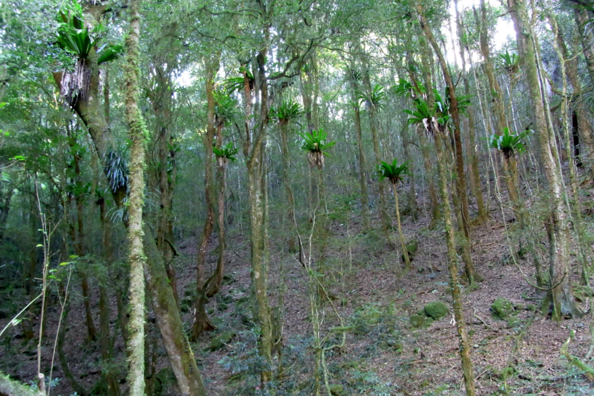
A dense forest interior featuring slender trees adorned with bird's nest ferns growing on their trunks, with a leaf-littered floor.
Rainforest foliage including native shatterwood and bird's nest ferns within Copeland Tops State Conservation Area.

Copeland Tops State Conservation Area history and protected-area timeline

The contemporary history of Copeland Tops begins with European gold discovery. Prospecting traces back to 1875, when timber collectors working in the forest found gold in the area. The find triggered a local rush, and by 1878 the population around the workings had risen to around one thousand people, with mining settlements springing up in what had previously been dense forest.

Two mines came to dominate the field. The Mountain Maid mine had yielded around 8,819 ounces of gold by the end of 1886, while the Hidden Treasure mine produced about 9,501 ounces over the same general period. Despite the richness of these early returns, most mining activity had ceased by 1890, and the landscape gradually returned to a quiet forested state. The Mountain Maid mine remains the most prominent surviving relic of this era and can still be visited with a tour guide.

In the modern era, the forested landscape around the old mine workings was recognised for its conservation value and formally protected as the Copeland Tops State Conservation Area on 1 July 2003. The reserve is now managed by the NSW National Parks and Wildlife Service, and the abandoned mine shafts have become an unlikely ecological asset, serving as daytime roosts for microbat colonies. This transition from short-lived mining frontier to protected landscape marks the defining arc of the area's human history.

Copeland Tops State Conservation Area landscape and geographic character

The landscape of Copeland Tops lies on the lower foothills and sheltered valleys between Gloucester and the higher Barrington Tops plateau. The terrain is undulating and forest-covered, with creek lines that cut through tall stands of eucalyptus and rainforest. Although elevation is modest compared with the higher peaks of the Barrington range, the topography provides the sheltered, humid microclimates that allow subtropical rainforest species to persist alongside wet eucalypt forest.

Water plays a quiet but important role in shaping the landscape. Drainage from the surrounding ranges feeds the creeks that wind through the reserve, sustaining the moisture-loving plant communities and contributing to the dense ground cover typical of wet sclerophyll forest. Steeper slopes and rocky outcrops add structural diversity to the terrain.

The old gold mining workings are themselves a landscape feature. Cut into hillsides and now partially overgrown, the diggings and shafts of the Mountain Maid mine and associated operations are signs of the area's nineteenth century industrial history, now softened by regrowing forest and integrated into the broader scenery of the reserve.

Copeland Tops State Conservation Area ecosystems, habitats, and plant life

Copeland Tops supports two ecologically distinct forest types that meet in a relatively small area. The dominant vegetation is wet sclerophyll eucalyptus forest, characterised by tall eucalypt trees with a moist, fern-rich understorey. This forest type is widespread across the wetter eastern slopes of the Barrington range and forms a baseline habitat across much of the reserve.

The most ecologically distinctive feature of Copeland Tops is its dry rainforest community. Within the wet eucalypt matrix, sheltered pockets of drier rainforest host a suite of typically subtropical species, including shatterwood, black booyong, Moreton Bay fig, and white cedar. Some red cedar specimens within the rainforest exceed forty metres in height, making them among the most striking trees in the reserve.

The rainforest canopy supports a rich epiphytic flora, including large bird's nest ferns, staghorn ferns, and elkhorn ferns that perch on trunks and branches. The combination of wet eucalypt forest, dry rainforest patches, and abundant moisture from local creek systems gives Copeland Tops an unusually layered vegetation profile for an inland Hunter Region reserve.

Copeland Tops State Conservation Area wildlife and species highlights

Wildlife is one of the strongest draws of Copeland Tops, with a rich assemblage of marsupials inhabiting both the eucalypt forest and the rainforest pockets. Koalas are present in the eucalypt forest, while eastern grey kangaroos are commonly seen in more open areas. Red-necked wallabies, wombats, and greater gliders, the last of which is a large gliding marsupial dependent on tall trees with hollows, round out the headline fauna.

The abandoned gold mine shafts provide an additional, less obvious wildlife habitat. Microbats use the dark, sheltered spaces inside the old workings as daytime roosts, turning relics of the 1870s mining rush into modern conservation assets for insectivorous bat species.

Together, the mix of canopy-dwelling mammals, ground-dwelling marsupials, and cave-roosting bats gives Copeland Tops a broad faunal profile that complements its botanically diverse forest.

Copeland Tops State Conservation Area conservation status and protection priorities

Copeland Tops is significant for conservation because it protects an unusual mosaic of wet sclerophyll eucalyptus forest and dry rainforest on the foothills of the Barrington range. The persistence of dry rainforest species such as shatterwood, black booyong, Moreton Bay fig, and very tall red cedar within a wet eucalypt landscape is uncommon in the Hunter Region, and the reserve helps safeguard rainforest species at the margins of their typical range.

The reserve also delivers fauna conservation outcomes through habitat protection. Continuous forest cover supports populations of koalas, eastern grey kangaroos, red-necked wallabies, wombats, and greater gliders, while the presence of very tall trees with hollows is particularly important for hollow-dependent species such as greater gliders. The unexpected conservation value of the abandoned gold mine shafts as microbat roosts adds a further dimension to the site's ecological importance.

Copeland Tops State Conservation Area cultural meaning and human context

The cultural identity of Copeland Tops is closely tied to the late nineteenth century gold rush that briefly transformed the area. Gold discovered by timber collectors in 1875 drew around one thousand people to what had been a quiet forested landscape by 1878, and the Mountain Maid mine in particular became a defining local landmark.

Although most mining activity ceased by 1890, the physical relics of that era, especially the Mountain Maid workings and their associated infrastructure, remain visible within the conservation area. The mine is now visited with a guide and interpreted as part of the area's heritage layer, allowing modern visitors to engage with both the natural and industrial past of the Barrington foothills.

Top sights and standout views in Copeland Tops State Conservation Area

Copeland Tops offers a layered combination of rainforest, tall eucalypt forest, and nineteenth century mining heritage within a single protected area. Standout highlights include the dry rainforest pockets with their towering red cedar and mature Moreton Bay fig, the visually arresting epiphytic fern colonies, and the interpretive tour of the Mountain Maid gold mine.

The reserve's accessibility from Gloucester and its proximity to the larger Barrington Tops also make it a practical anchor for exploring the broader Hunter Region forests. Its wildlife profile, particularly koalas, red-necked wallabies, greater gliders, and the microbats that roost in the old mine shafts, rounds out a set of features that distinguish Copeland Tops from neighbouring reserves.

Best time to visit Copeland Tops State Conservation Area

Because Copeland Tops sits in a wet, forested part of the Hunter Region, the cooler months of late autumn, winter, and early spring tend to offer a quieter atmosphere, comfortable walking conditions, and good visibility in the tall forests for both birdwatching and general wildlife observation. The rainforest pockets with their epiphytic ferns are most striking in the wetter part of the year, when moisture levels are high and the ferns are at their most lush.

Summer can be warm and humid, and visitors should be prepared for variable terrain and creek-side conditions year-round. The Mountain Maid gold mine site can be visited with a tour guide, and guided mine tours are typically easiest to plan around the cooler and drier months, when access to the workings and surrounding tracks is generally most comfortable.

Monthly climate preview

Examine long-term representative temperature ranges and monthly precipitation distributions

Copeland Tops State Conservation Area Climate Normals and Annual Weather Patterns

Historical climate records for Copeland Tops State Conservation Area show a measured annual rhythm spanning warm summer months and cooler winter periods alongside varying daily precipitation. Reviewing the complete twelve-month profile provides deeper analytical insight into average temperature shifts and precipitation metrics.
Annual mean17 °C
10 °C23 °C
Jan23°
Feb22°
Mar20°
Apr17°
May13°
Jun11°
Jul10°
Aug11°
Sep14°
Oct17°
Nov19°
Dec21°
Warmest month
January

22.8 °C

Coolest month
July

9.9 °C

Wettest month
February

4.6 mm/day

Driest month
August

1.6 mm/day

Park location guide

Geography guide, regional context, and park location map for Copeland Tops State Conservation Area

Copeland Tops State Conservation Area park geography, regions, and map view in Australia

Understand where Copeland Tops State Conservation Area sits in Australia through a broader geographic reading of the surrounding landscape, nearby location context, and its mapped position within the national park landscape.

How Copeland Tops State Conservation Area fits into Australia

Australia is a constitutional monarchy and federal parliamentary democracy comprising six states and ten territories. With a population of nearly 28 million, it is one of the world's most urbanised countries, with most people concentrated on the eastern seaboard. The country has a high Human Development Index and is known for its cultural diversity, ancient Aboriginal heritage, and unique wildlife.

Wider geography shaping Copeland Tops State Conservation Area in Australia

Australia occupies the entire Australian continent, the island of Tasmania, and numerous smaller islands. It is the world's flattest and driest inhabited continent, featuring vast deserts in the interior (the Outback), tropical rainforests along the eastern coast, and a coastline bordering the Indian and Pacific Oceans.

Map view of Copeland Tops State Conservation Area

Use this park location map to pinpoint Copeland Tops State Conservation Area in Australia, understand its exact geographic position, and read its mapped placement within the surrounding landscape more clearly.

Pigeon | © OpenStreetMap contributors

Location context for Copeland Tops State Conservation Area

New South Wales

Visual reference of wet sclerophyll forests, rainforest pockets, and historic mining terrain

Copeland Tops State Conservation Area Photos, Scenery, and Protected Landscape Views

Visual records capture the distinctive forest habitats, undulating foothills, and dense fern growth that define Copeland Tops State Conservation Area. Photographic documentation reveals the interplay of wet eucalyptus stands and dry rainforest communities across the New South Wales landscape.

A dense forest interior featuring slender trees adorned with bird's nest ferns growing on their trunks, with a leaf-littered floor.

Park atlas

Compare adjacent forest reserves and protected landscapes across the surrounding region

Other Parks Near Copeland Tops State Conservation Area and Regional Protected Lands

Browsing nearby national parks and protected areas provides deeper geographic context for the foothills and forests surrounding Copeland Tops State Conservation Area. Evaluating adjacent reserves reveals shared ecological traits, regional terrain patterns, and broader conservation corridors throughout the Hunter Region.
Watercolor illustration of a river flowing through hills with distant mountains and pink trees
National parkNew South Wales
11 km away#1 closest

West

Barrington Tops National Park: A Protected National Park in New South Wales

Explore ancient Gondwana rainforests and dramatic volcanic terrain.

Barrington Tops National Park represents a significant protected landscape in New South Wales, Australia, offering a deep dive into diverse ecosystems. Its unique altitudinal vegetation gradient supports the southernmost subtropical rainforests in Australia and showcases geological formations dating back millions of years. This park is crucial for understanding Australia's natural heritage, providing a rich context for landscape exploration and the study of ancient flora within a mapped geographic setting.

Area
765.12 km²
Established
1969
IUCN
Ib
Relief
Mountain
National parkNew South Wales
15 km away#2 closest

North

Woko National Park: Explore Its Protected Landscape and Geographic Boundaries

Discover the mapped terrain and regional atlas context of Woko National Park.

Woko National Park presents a unique opportunity for geographic discovery, situated within New South Wales, Australia. This detail page focuses on the park's protected landscape and its mapped boundaries, providing a clear understanding of its geographic identity. Engage with Woko National Park as a key component of the Australian national park atlas, highlighting its regional setting and natural terrain.

Area
85.98 km²
Established
1982
IUCN
II
Relief
Highland
A horizontal watercolor painting depicting a soft landscape with distant purple hills, a meandering stream, and green grassy foreground vegetation.
Protected areaNew South Wales
17 km away#3 closest

West

Barrington Tops State Conservation Area: Protected Plateau and Volcanic Landscape Context

Highland geography within the Mount Royal Range, New South Wales

This protected area represents a significant upland region in New South Wales, characterized by weathered plateau edges and cool mountain environments. The terrain supports high-altitude peat wetlands and diverse montane forests, rooted in the ancient geological legacy of the Barrington Volcano. Its protected boundaries link directly to the Gondwana Rainforests, providing essential habitat continuity across the Great Dividing Range.

Area
84.46 km²
Established
2003
Relief
Mountain
Climate
Temperate
A horizontal watercolor painting showing rolling green hills and a forest with soft pink and green tones.
Nature reserveNew South Wales
24 km away#4 closest

South

Black Bulga State Conservation Area: Forest Geography and Protected Area Overview

A vital ecological refuge in the Hunter Region of New South Wales

Black Bulga State Conservation Area encompasses a diverse bushland mosaic of Sydney blue gum, tallowwood, and subtropical rainforest patches. This reserve highlights the abrupt shifts in terrain and vegetation typical of the Barrington Tops foothills, providing a stable habitat for koalas and various marsupials within its protected boundaries.

Area
15.54 km²
Established
2003
IUCN
Ia
Relief
Upland
Nature reserveNew South Wales
About 25 km away#5 closest

North

Bretti Nature Reserve: Geography and Protected Escarpment Landscapes in New South Wales

Mapped riverine corridors and wet forest ecosystems

Bretti Nature Reserve serves as a vital conservation anchor in the Hunter Region, protecting a rare mix of subtropical rainforest and wet sclerophyll forest. This detailed record maps the reserve's position along the Bernard River, illustrating its role as a landscape-scale link within the Great Eastern Escarpment's diverse mountain terrain.

Area
29.02 km²
Established
1999
IUCN
Ia
Relief
Mountain
Nature reserveNew South Wales
About 26 km away#6 closest

Southeast

The Glen Nature Reserve: Protected Forest Geography and Mapped Sanctuary in New South Wales

Conservation-focused landscape in the Hunter Region

Covering over 2,700 hectares, The Glen Nature Reserve protects a rich mosaic of sub-tropical sclerophyll forest and creek-lined gullies in the Hunter Region. The reserve provides essential habitat for threatened wildlife and represents a key node in the protected land network of eastern New South Wales, highlighting the intersection of forest types and local watershed topography.

Area
27.5 km²
Established
1999
IUCN
Ia
Relief
Upland
National parkNew South Wales
30 km away#7 closest

North

Barakee National Park: New South Wales Protected Landscape Atlas Explorer

Mapped Boundaries and Regional Geography Insights

Barakee National Park is a vital component of New South Wales's protected natural areas, offering a focused point for geographic discovery. This page provides key details on its protected landscape identity and its place within the mapped terrain of the region. Examine the structured data to grasp the park's geographic footprint and understand its significance as a designated national park within Australia.

Area
50.11 km²
Established
1999
IUCN
II
Relief
Mixed relief
National parkNew South Wales
33 km away#8 closest

Southeast

Ghin-Doo-Ee National Park: National Park Protected Area Exploration in New South Wales

Mapped landscape and regional geography for Ghin-Doo-Ee National Park.

Ghin-Doo-Ee National Park represents a key component of Australia's protected lands, situated within the diverse geography of New South Wales. This park offers a structured point of entry for understanding its specific mapped boundaries, terrain characteristics, and its role as a national park. Users can delve into its unique landscape features and regional geographic context, contributing to a broader appreciation of conservation areas and natural atlas exploration.

Area
47.936 km²
Established
1999
IUCN
II
Relief
Upland

Common questions about visiting, size, designation, and location context for Copeland Tops State Conservation Area

Copeland Tops State Conservation Area FAQs for park facts, access, geography, and protected area context

Find quick answers about Copeland Tops State Conservation Area, including protected-area facts, park geography, trail and visitor context, and how the park fits into its surrounding country and regional landscape.
MoriAtlas Explorer

Continue Your Protected Areas Search Across the Global Atlas

Deepen your exploration by continuing the structured search for national parks and protected areas worldwide. Utilize the comprehensive filtering capabilities to compare different conservation landscapes and refine your understanding of global park geography. Discover more about the distribution and characteristics of protected natural areas.

Global natural geography