

Mori Atlas logo
National parkDadohaehaesang National Park

Discover the mapped boundaries and regional geography of this significant national park.

Dadohaehaesang National Park: South Korea's Coastal Protected Landscape and Geographic Identity

Dadohaehaesang National Park represents a key protected area within South Korea's natural heritage. This national park offers insights into the country's unique geographic features and coastal landscapes. Through detailed mapping and geographic context, users can explore the protected boundaries and understand the regional landscape distribution of Dadohaehaesang National Park, contributing to a richer atlas of global conservation areas.

Marine national parkArchipelagoCoastal ecosystemsIsland landscapeSouth Korea national parksIUCN Category II

Dadohaehaesang National Park

National park

Park overview

Structured park overview, official facts, and landscape profile for Dadohaehaesang National Park

Dadohaehaesang National Park park facts, protected area profile, and essential visitor context
Review the core facts for Dadohaehaesang National Park, including designation, size, terrain, visitor scale, habitats, and operating context in one park-focused overview.

About Dadohaehaesang National Park

Dadohaehaesang National Park occupies a unique position in South Korea's protected area network as the nation's largest national park and one of its most distinctly maritime-oriented reserves. The park stretches along the southern coast of the Korean Peninsula, protecting a collection of islands, coastal waters, and adjacent terrestrial areas that together form an integrated coastal-marine ecosystem. The establishment of the park in 1981 reflected growing recognition that Korea's southern island coasts represented a nationally significant natural heritage requiring coordinated protection. Unlike most Korean national parks which focus primarily on mountain forests and terrestrial environments, Dadohaehaesang centers on marine and island ecosystems, with tidal zones, rocky shores, and open sea environments forming the core of the protected landscape. The park's islands vary considerably in size and character, with some supporting small communities while others remain uninhabited and largely pristine. The marine waters surrounding the islands are biologically productive, supporting the diverse fish and invertebrate communities that contribute to the park's ecological significance. Visitor facilities are concentrated on the larger islands, where hiking trails, viewpoints, and coastal access points allow exploration of the park's landscapes. The management approach balances conservation objectives with sustainable recreation, recognizing both the ecological sensitivity of marine environments and the importance of the park as a destination for environmental education and appreciation.

Quick facts and research context for Dadohaehaesang National Park

Dadohaehaesang National Park is the largest of South Korea's twenty-two national parks, covering 2,321.5 square kilometers with marine waters comprising roughly 86% of its total area. Established on December 23, 1981, the park protects a chain of islands and coastal waters along the southern Korean Peninsula. The park supports remarkable biodiversity, including 1,541 plant species, over 11 mammal species, 147 bird species, 885 insect species, and more than 150 fish species. Notably, the park provides habitat for orca (killer whales) and other marine mammals, making it significant for marine conservation in East Asia. The Korea National Park Service administers the park, which receives around 560,000 visitors per year.

Park context

Deeper park guide and search-rich context for Dadohaehaesang National Park

Dadohaehaesang National Park history, landscape, wildlife, and travel context
Explore Dadohaehaesang National Park through its history, landscape character, ecosystems, wildlife, conservation priorities, cultural context, and seasonal travel timing in a structured park guide built for atlas discovery and search intent.

Why Dadohaehaesang National Park stands out

Dadohaehaesang National Park is best known for its spectacular maritime archipelago landscape, where dozens of islands rise from productive coastal waters creating a distinctive scattering of land across the sea. Hongdo Island stands as perhaps the most recognizable feature, with its dramatic coastal scenery and natural beauty. The park is notable for combining dramatic island and cliff landscapes with exceptional marine biodiversity, including populations of orca and other cetaceans that are rarely found in Korean waters. The contrast between the forested island interiors and the surrounding marine environments creates a coherent coastal ecosystem that is unusual among East Asian national parks. The park also serves as an important area for migratory birds and supports diverse coastal and nearshore marine communities.

Dadohaehaesang National Park history and protected-area timeline

Dadohaehaesang National Park was officially designated on December 23, 1981, becoming South Korea's largest national park at establishment and retaining that distinction today. The creation of the park represented a significant expansion of South Korea's national park system into marine and coastal environments, reflecting evolving perspectives on the value of protecting oceanic and island ecosystems rather than focusing exclusively on mountain forests. Prior to national park designation, many of the individual islands and coastal areas within the park had been subject to varying levels of local protection or traditional use management, but the 1981 designation consolidated these into a comprehensive protected area framework. The establishment came during a period of rapid growth in South Korea's environmental awareness and conservation capacity, as the nation developed more sophisticated approaches to biodiversity preservation and ecosystem management. Management responsibility was assigned to the Korea National Park Service, which applied the same institutional framework used for Korea's terrestrial national parks while developing specialized approaches for marine and coastal zone management. Over the subsequent decades, the park has maintained its conservation mandate while developing visitor infrastructure and programs. The park's designation as an IUCN Category II protected area reflects international recognition of its significance as a national park with substantial natural and scenic values.

Dadohaehaesang National Park landscape and geographic character

The landscape of Dadohaehaesang National Park is defined by the interaction between Korea's mountainous southern coastline and the productive seas that surround it. The park encompasses numerous islands of varying sizes, many featuring rugged terrain with steep coastal cliffs, forested slopes, and sheltered coves. The islands rise from relatively shallow coastal waters, creating a scattered archipelago pattern that distinguishes this park from the more compact mountain-focused reserves found elsewhere in Korea. Hongdo Island, as one of the primary attractions within the park, showcases the characteristic combination of dramatic rocky coastlines and dense vegetation that characterizes much of the island landscapes. The marine environment ranges from sheltered tidal zones near shore to more open coastal waters, with underwater topography that supports diverse benthic communities. The terrestrial portions of the park feature the rolling topography typical of Korea's southern regions, with hills and valleys supporting forests that contrast with the open marine views surrounding each island. The seasonal weather patterns of this southern coastal region influence the landscape character, with summer bringing lush green conditions and winter revealing more stark island silhouettes against gray seas.

Dadohaehaesang National Park ecosystems, habitats, and plant life

The ecological character of Dadohaehaesang National Park reflects its position at the interface between Korean terrestrial and marine environments, creating a hybrid ecosystem of considerable complexity and biodiversity. The park supports approximately 1,541 plant species across its terrestrial areas, with forests dominated by mixed deciduous and evergreen species suited to the warm temperate climate of Korea's southern coast. The marine component of the park encompasses a range of habitat types from shallow intertidal zones to deeper coastal waters, each supporting distinctive biological communities. The productive coastal waters support dense populations of fish, invertebrates, and marine algae, creating the foundation for a food web that includes larger marine predators. The interface between land and sea is particularly significant, with tidal pools, rocky shores, and coastal wetlands providing critical habitat for many species. The park's biodiversity inventory includes 885 insect species and 13 amphibian and reptile species, indicating substantial terrestrial and freshwater ecosystem complexity in addition to the prominent marine elements.

Dadohaehaesang National Park wildlife and species highlights

The wildlife of Dadohaehaesang National Park is notable for the presence of marine mammals that are otherwise rare in Korean waters, most prominently the orca or killer whale. The occurrence of orca in the park's waters represents one of the few documented populations of this species along the Korean coast, making the park particularly significant for marine mammal conservation in East Asia. Beyond orca, the park supports more than 11 mammal species overall, with the terrestrial component hosting typical Korean wildlife including various small mammals and potentially larger species adapted to forested island environments. The bird diversity is substantial, with 147 species recorded within the park, reflecting the importance of the coastal and island environments as migratory pathways and breeding habitat. The marine fish community is exceptionally diverse, with 154 ocean water fish species and 11 freshwater fish species documented, indicating the ecological richness of both the marine waters and the streams and wetlands found on the islands. The insect fauna of 885 species further demonstrates the biological productivity of this coastal ecosystem.

Dadohaehaesang National Park conservation status and protection priorities

Dadohaehaesang National Park represents South Korea's primary marine and island conservation area, protecting a coastal ecosystem type that is underrepresented in the nation's protected area network. The park's significance extends beyond its size to encompass the unique combination of marine and terrestrial habitats it preserves, including populations of species such as orca that have limited protected habitat elsewhere in Korean waters. The IUCN Category II designation acknowledges the park's substantial natural values and its role in protecting representative examples of Korea's coastal and island ecosystems. Management by the Korea National Park Service applies integrated approaches that address both terrestrial and marine conservation objectives, recognizing the ecological connections between island forests and surrounding waters. The park's biodiversity credentials are reinforced by the extensive species inventories that have documented over 1,500 plant species, nearly 150 bird species, and hundreds of marine and freshwater species within its boundaries. As the largest national park in South Korea, Dadohaehaesang provides a significant conservation baseline for understanding Korean marine biodiversity and the ecological requirements of coastal island ecosystems.

Dadohaehaesang National Park cultural meaning and human context

The islands within Dadohaehaesang National Park have been part of Korean maritime cultural heritage for centuries, with fishing communities maintaining traditional relationships with the surrounding seas. Some of the larger islands within the park have historically supported small agricultural and fishing communities whose practices have shaped local land use patterns and coastal management traditions. The park's name, combining Korean characters meaning islands, sea, and maritime, directly reflects this cultural connection to the coastal and island environment. While the park is managed primarily for nature conservation rather than cultural heritage preservation, the human dimensions of the landscape remain acknowledged in management approaches that consider the relationship between local communities and the natural environments they have historically inhabited. The traditional maritime cultural context adds depth to the park's identity, though the primary conservation focus remains on the natural ecosystems rather than explicitly cultural or historical resources.

Top sights and standout views in Dadohaehaesang National Park

The archipelago landscape of Dadohaehaesang National Park, with its scattered islands rising from productive coastal waters, represents one of Korea's most distinctive protected seascapes. Hongdo Island stands as the park's signature attraction, offering dramatic coastal scenery, hiking opportunities, and the visual impact of a well-forested island emerging directly from the sea. The presence of orca in the park's marine waters distinguishes this park from virtually all other Korean national parks, providing rare opportunities for marine mammal observation in a protected context. The combination of forested island interiors, rugged coastlines, and biologically rich marine environments creates an integrated coastal ecosystem that is uncommon in East Asian protected areas. As South Korea's largest national park, Dadohaehaesang provides extensive opportunities for exploration and discovery across both land and sea, with visitor facilities concentrated on the larger islands while smaller outlying islands and surrounding waters remain in a more wild condition.

Best time to visit Dadohaehaesang National Park

Dadohaehaesang National Park can be visited throughout the year, though the character of the experience varies substantially with the seasons. Spring and autumn generally offer the most comfortable conditions for outdoor exploration, with moderate temperatures and clear skies providing good visibility for appreciating the island landscapes and coastal views. These seasons also coincide with peak migratory bird activity, making them particularly rewarding for birdwatching within the park. Summer brings warmer temperatures and the lush green conditions typical of the Korean growing season, though increased visitor numbers and higher humidity are factors to consider. Winter reveals the islands in a more stark character, with deciduous trees bare and the possibility of dramatic coastal weather adding to the atmosphere, though some visitor facilities may have reduced operational schedules. The marine environment is accessible year-round, though water activities are naturally more comfortable during the warmer months.
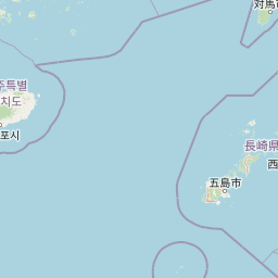
Park location guide

Geography guide, regional context, and park location map for Dadohaehaesang National Park

Dadohaehaesang National Park park geography, regions, and map view in South Korea
Understand where Dadohaehaesang National Park sits in South Korea through a broader geographic reading of the surrounding landscape, nearby location context, and its mapped position within the national park landscape.

How Dadohaehaesang National Park fits into South Korea

South Korea is a presidential republic on the Korean Peninsula in East Asia. It has a population of about 51 million and Seoul as its capital and largest city. The country is known for its rapid economic development, high technology industry, and cultural exports.

Wider geography shaping Dadohaehaesang National Park in South Korea

South Korea occupies the southern half of the Korean Peninsula in East Asia. It borders North Korea along the Demilitarized Zone to the north, the Yellow Sea to the west, and the Sea of Japan to the east. The terrain is predominantly mountainous with coastal plains along the southern and eastern shores.

Map view of Dadohaehaesang National Park

Use this park location map to pinpoint Dadohaehaesang National Park in South Korea, understand its exact geographic position, and read its mapped placement within the surrounding landscape more clearly.

Pigeon | © OpenStreetMap contributors
Park atlas

Trace the Regional Geography and Protected Landscape Spread Around Dadohaehaesang National Park, Exploring Connected Coastal and Island Ecosystems.

Continue Your Discovery: Nearby National Parks and Protected Areas Around Dadohaehaesang National Park
After exploring Dadohaehaesang National Park's unique maritime archipelago, browse other prominent national parks and protected areas across South Korea's southern coastline and adjacent marine environments. Compare distinct park geographies, conservation priorities, and diverse coastal, island, and terrestrial landscapes to expand your understanding of the region's interconnected protected-area network.
National parkJeollanam-do

Wolchulsan National Park: Detailed Geographic and Protected Landscape Atlas Entry

Explore mapped boundaries and natural terrain context.

This MoriAtlas entry for Wolchulsan National Park provides a detailed look at its identity as a protected landscape within Jeollanam-do, South Korea. Focus is placed on its geographic context and mapped park boundaries, offering a foundation for understanding its place in the regional atlas. Discover the structured details of this national park's natural terrain and its significance as a preserved natural area.

Area
56.6 km²
Established
1988
IUCN
II
Relief
Mountain
National parkJeju Province

Hallasan National Park: South Korea's Highest Mountain National Park on Jeju

Volcanic Terrain and Mapped Protected Boundaries

Hallasan National Park encompasses South Korea's highest mountain, a massive shield volcano on Jeju Island. This page details the park's protected landscape, from sub-tropical forests to alpine environments, and its prominent role within Jeju Province's geography. Discover its mapped terrain and unique geological features, including the summit crater lake Baekrokdam.

Area
153.11 km²
Established
1970
IUCN
II
Relief
Mountain
National parkJeollanam-do

Mudeungsan National Park: Mapped Protected Landscape and Regional Geography Context

Explore Mudeungsan National Park's geographic setting in Jeollanam-do.

Mudeungsan National Park offers a distinct protected landscape within the Jeollanam-do region of South Korea. This atlas-focused page details its mapped geographic boundaries and the surrounding natural terrain, providing essential context for understanding its role as a national park. Explore the park's identity through its unique landscape and regional geography.

Area
75.45 km²
Established
2012
IUCN
II
Relief
Mountain
National parkSouth Korea

Hallyeohaesang National Park: South Korea National Park Geographic Atlas Entry

Explore mapped protected area boundaries and natural terrain.

As a designated national park in South Korea, Hallyeohaesang National Park offers a distinct geographic profile crucial for atlas exploration. This entry focuses on its protected landscape features, mapped territorial extent, and regional context within the Republic of Korea. Understand the park's specific geographical markers and its significance as a mapped protected area.

Area
545.63 km²
Established
1968
IUCN
II
Access
Access unknown
National parkSouth Korea

Naejangsan National Park: South Korea's Mapped Protected Landscape and Geography

Discover the park's protected boundaries and regional context.

Investigate Naejangsan National Park, a protected area within South Korea, through its mapped geography and landscape context. This detailed atlas entry provides insight into the park's specific geographic identity and its role as a national park, offering a structured understanding of its protected natural features for focused exploration and research.

Area
81.45 km²
Established
1971
IUCN
II
Relief
Mountain
National parkSouth Korea

Jirisan National Park: South Korea's Premier Protected Landscape and Map Resource

Explore the mapped terrain and protected area geography.

Jirisan National Park is a key protected area within South Korea, serving as a vital component of the nation's natural landscape. This atlas-focused content provides detailed geographic information, highlighting the park's mapped boundaries and its role within the regional context of the Korean Peninsula. Understand the distinct characteristics of this protected national park for comprehensive geographic discovery.

Area
471.75 km²
Established
1967
IUCN
II
Visitors
1.5M annual
National parkJeollabuk-do

Byeonsan-bando National Park: Protected Landscape and Geographic Context in Jeollabuk-do

Explore mapped terrain and regional park geography.

This detail page provides an in-depth look at Byeonsan-bando National Park, a protected area located in South Korea's Jeollabuk-do region. Users can discover the park's specific geographic identity, understand its mapped boundaries, and explore its role within the broader regional landscape. The content is structured for atlas exploration, offering detailed insights into the park's natural terrain and its significance as a national park.

Area
154.71 km²
Established
1988
IUCN
II
Relief
Mixed relief
National parkJeollabuk-do

Deogyusan National Park: National Park Identity and Geographic Mapping

Explore its protected land boundaries and regional landscape context.

Examine Deogyusan National Park, a designated national park situated in the Jeollabuk-do region of South Korea. This entry provides critical geographic context, focusing on the park's mapped boundaries and its role as a protected landscape. Users can gain a structured understanding of its natural terrain and regional significance, contributing to a broader atlas of protected areas.

Area
231.65 km²
Established
1975
IUCN
V
Visitors
1M annual

Common questions about visiting, size, designation, and location context for Dadohaehaesang National Park

Dadohaehaesang National Park FAQs for park facts, access, geography, and protected area context
Find quick answers about Dadohaehaesang National Park, including protected-area facts, park geography, trail and visitor context, and how the park fits into its surrounding country and regional landscape.
MoriAtlas Explorer

Continue Your Protected Areas Search Across the Global Atlas

Deepen your exploration by continuing the structured search for national parks and protected areas worldwide. Utilize the comprehensive filtering capabilities to compare different conservation landscapes and refine your understanding of global park geography. Discover more about the distribution and characteristics of protected natural areas.

Global natural geography