
Mori Atlas logo
National parkEin Avdat

Trace the mapped geography of springs, waterfalls, and ancient sites within the Negev Desert.

Ein Avdat National Park: Israel's Dramatic Desert Oasis and Protected Landscape

(Ein Avdat National Park)

Ein Avdat National Park in Israel's Negev Desert protects a spectacular natural oasis, renowned for its fresh springs, cascading waterfalls, and deep pools that provide a striking contrast to the arid surroundings. This unique protected landscape, carved by the Nahal Zin wadi, preserves not only geological wonders but also thousands of years of human history, including Nabatean settlements and Byzantine monastic caves, offering unparalleled insight into desert adaptation and landscape preservation.

desert canyonnatural springswaterfallNegev desertNabatean heritageByzantine archaeology
Stylized illustration of a canyon with a waterfall, green trees, and rocky cliffs under a sunny sky

Ein Avdat

National park

Park overview

Structured park overview, official facts, and landscape profile for Ein Avdat

Ein Avdat park facts, protected area profile, and essential visitor context

Review the core facts for Ein Avdat, including designation, size, terrain, visitor scale, habitats, and operating context in one park-focused overview.

About Ein Avdat

Ein Avdat represents one of the most striking natural and cultural landmarks in Israel's desert landscape, where the stark beauty of the Negev meets a rich tapestry of human history. The canyon was formed by the erosive forces of Nahal Zin, the longest wadi in the Negev, which begins at the northwestern edge of Makhtesh Ramon and flows across the desert before turning sharply eastward through the park. The springs that define Ein Avdat emerge from geological layers deep within the canyon, creating a lush riparian environment that stands in dramatic contrast to the surrounding barren terrain. This ecological anomaly has drawn human communities for tens of thousands of years, as evidenced by flint artifacts from the Mousterian culture dating back 80,000 to 90,000 years, as well as Bronze Age settlement remains. The park's cultural significance reached its peak during the Nabatean period when Avdat became a station along the ancient Incense Route connecting Egypt to India, and later during Byzantine times when monks established a monastic community in the canyon caves. Today, the Israel Nature and Parks Authority manages the 480-hectare reserve, which receives between 120 and 500 daily visitors who come to experience its unique combination of natural beauty, historical depth, and desert hiking opportunities.

Quick facts and research context for Ein Avdat

Ein Avdat National Park encompasses roughly 480 hectares of desert canyon terrain in the Negev region of Israel. The canyon features multiple springs including Ein Ma'arif, the main Ein Avdat spring with its 15-meter waterfall emptying into an 8-meter deep pool, and Ein Mor near the northern entrance. The area sits within Nahal Zin, the longest wadi system in the Negev, which originates at Makhtesh Ramon and runs approximately 120 kilometers. The park preserves evidence of continuous human presence from the Paleolithic period through the Nabatean and Byzantine eras, making it one of Israel's most historically layered natural sites.

Protection and recognition

Verifying terrestrial conservation management scope and official geographic records for the reserve

Documented Protection Status and Conservation Profile of Ein Avdat

Geographic researchers can examine the official terrestrial protection status and established boundaries recorded for Ein Avdat. Evaluating verified conservation data offers clear insights into regional land management patterns and environmental preservation initiatives across the wider desert landscape.

Protection details

Protection scope
Terrestrial
Transboundary protection
No
Park context

Deeper park guide and search-rich context for Ein Avdat

Ein Avdat history, landscape, wildlife, and travel context

Explore Ein Avdat through its history, landscape character, ecosystems, wildlife, conservation priorities, cultural context, and seasonal travel timing in a structured park guide built for atlas discovery and search intent.

Why Ein Avdat stands out

Ein Avdat is best known for its spectacular desert springs and waterfalls that create an unexpected oasis environment in one of Israel's harshest landscapes. The main waterfall reaches 15 meters in height, descending into an 8-meter deep pool divided by a small artificial dam. The park is equally renowned for its well-preserved Byzantine-era cave monastery, where monks carved closets, shelves, benches, stairs, and water systems into the canyon walls during the 3rd to 6th centuries. The canyon also serves as a critical habitat for griffon vultures and Egyptian vultures that nest on the cliff faces, making it an important raptor conservation area within the desert ecosystem.
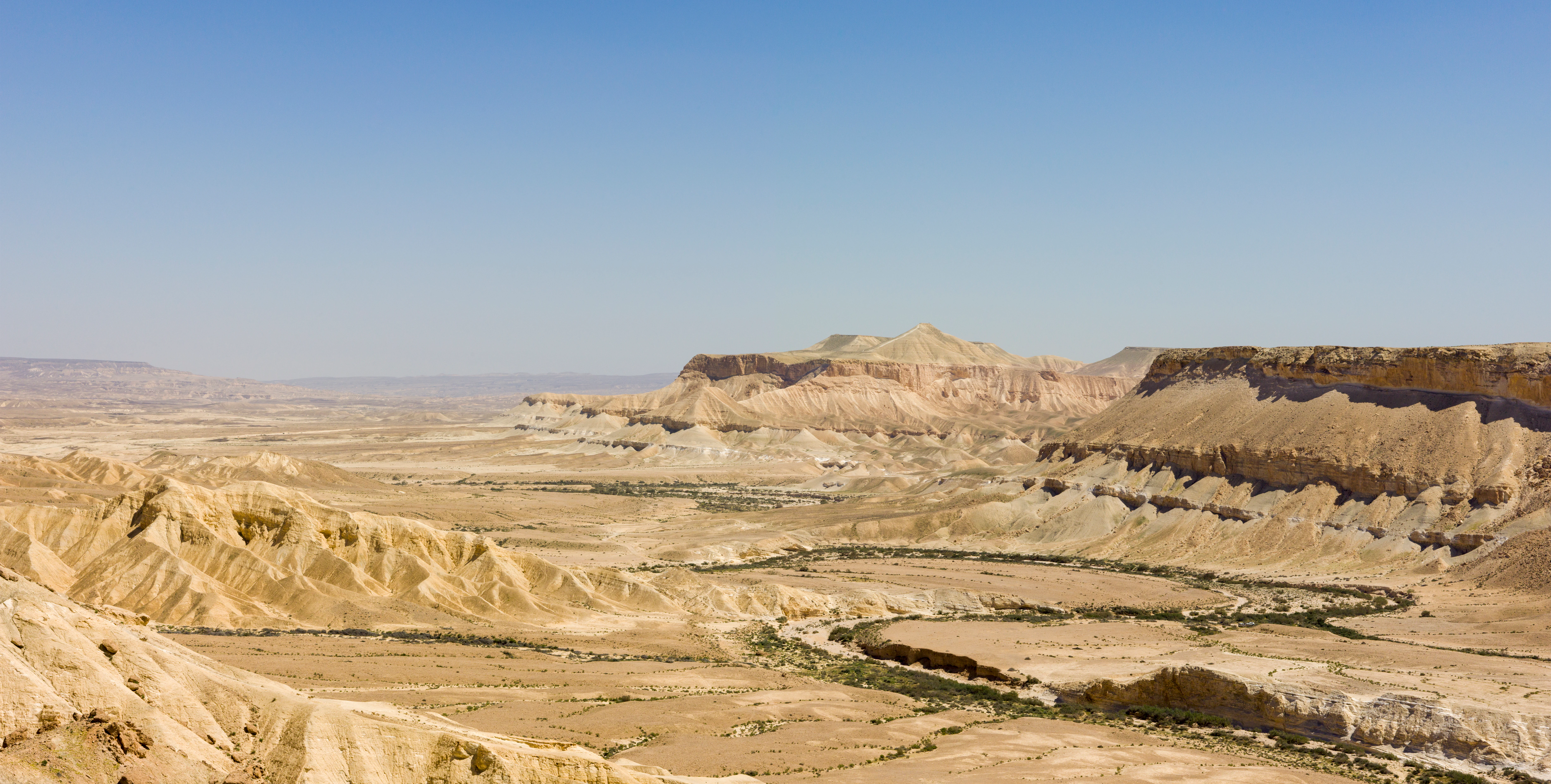
Wide view of Ein Avdat canyon with rocky terrain, desert valleys, and distant mountains under a clear blue sky
Panoramic view of Ein Avdat canyon in the Negev Desert, Israel

Ein Avdat history and protected-area timeline

The human history of Ein Avdat spans an extraordinary breadth of time, beginning with prehistoric inhabitants who left behind flint artifacts, Mousterian stone tools, and animal remains including ostrich egg shells and onager bones dating to approximately 200,000 years ago. During the Hellenistic period, the site became integrated into the Nabatean Incense Route, a major ancient trading corridor linking Egypt through the Arabian Peninsula to India. Avdat evolved from a waypoint station into a thriving city with public buildings and agricultural enterprises during the Roman era. The Byzantine period saw the canyon become home to a monastic community of Christian monks who carved extensive cave dwellings into the canyon walls, installing closets, shelves, benches, and even water channels. These monks also decorated cave walls with crosses and prayers, and constructed what is now recognized as one of the earliest and best-preserved Byzantine churches predating Emperor Constantine's recognition of Christianity. Following the Muslim conquest of Palestine, the region was abandoned for centuries. The modern era began in 1952 when Kibbutz Sde Boker was established, followed by the construction of Highway 40 to Eilat and the creation of hiking trails that made the canyon accessible to the public. The site was designated as a National Park of Israel and is now administered by the Israel Nature and Parks Authority.

Ein Avdat landscape and geographic character

The landscape of Ein Avdat is defined by the dramatic contrast between harsh desert canyon terrain and a verdant spring-fed oasis. The canyon walls rise steeply along the Nahal Zin wadi, composed of typical Negev sandstone and limestone formations that have been sculpted by water erosion into vertical faces, shelves, and hidden caves. At the southern end of the canyon, multiple springs emerge from the rock layers, creating a series of waterfalls that descend into deep natural pools. The main spring features a 15-meter waterfall that feeds an 8-meter deep pool, while further north, Ein Mor spring produces water with a slightly different character. The surrounding desert is characteristic of the central Negev, characterized by sparse vegetation, extreme temperature variations, and an absence of permanent surface water. However, the canyon micro-habitat supports significantly more diverse flora where water is present, with poplar trees, tamarisks, and various wetland plants growing along the watercourses. The canyon provides dramatic vertical relief and varied topography, from the narrow gorge sections to wider areas where the springs create broader pool systems.
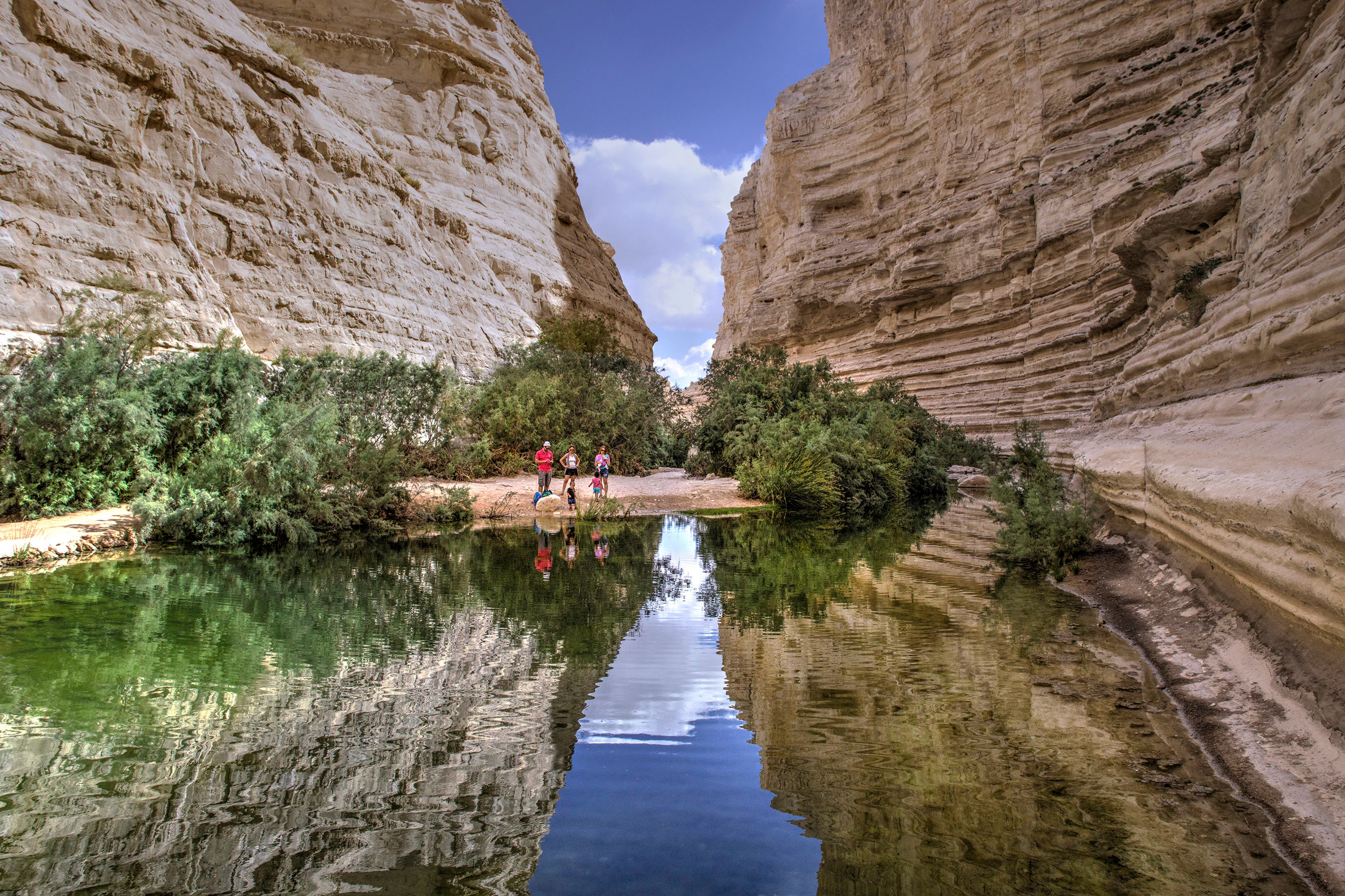
Calm spring water reflecting rocky canyon walls, vegetation, and two people standing at the water's edge under a clear sky.
Two people standing at the Ein Avdat spring in the Negev Desert, Israel.

Ein Avdat ecosystems, habitats, and plant life

The ecological character of Ein Avdat centers on its unique riparian oasis environment within an otherwise arid desert ecosystem. Around the springs and water channels, Euphrates poplar trees create canopy cover, while Atriplex (saltbush) dominates the riverbanks, demonstrating the plants' remarkable tolerance for salinity. Tamarisks, salt trees, common reeds, lesser bulrush, and sea rush form the core wetland vegetation community. On the moist canyon walls, maidenhair ferns and lichen cling to shaded surfaces, while various algae species grow in the slow-moving water. The dryer areas of the canyon support different plant communities including bushy bean caper and saltworth. A single large Mt Atlas mastic (pistacia atlantica) tree grows near the park entrance, serving as a notable landmark. The aquatic environment supports populations of European green toads, Levant freshwater crabs, and insect larvae including Culiseta mosquitoes and desert skimmer dragonflies. This combination of aquatic and desert habitats creates an ecological island of biodiversity in the heart of the Negev.
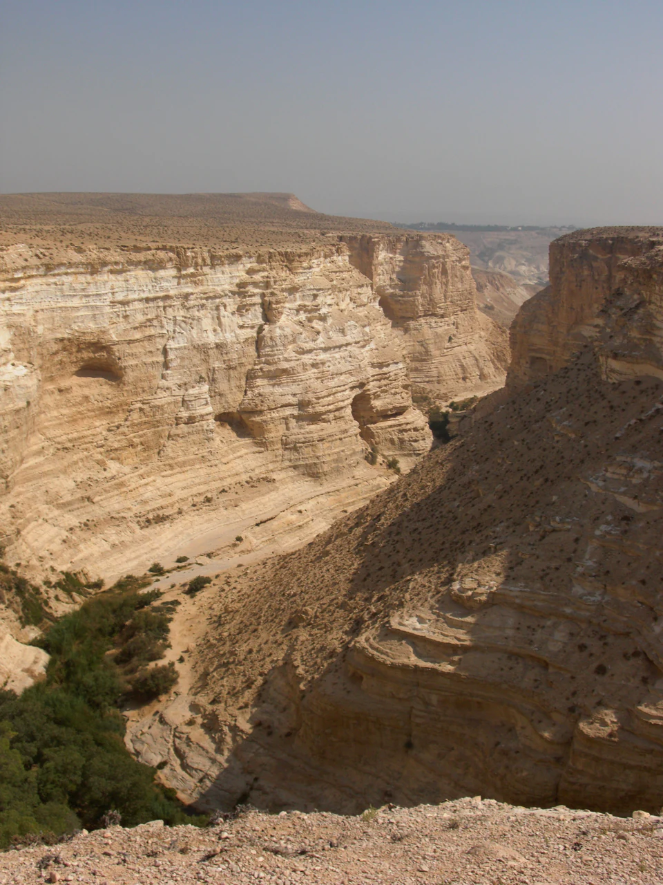
Rocky canyon with layered cliffs and sparse vegetation under clear sky.
Canyon landscape of Ein Avdat National Park.

Ein Avdat wildlife and species highlights

Ein Avdat supports a diverse assembly of wildlife adapted to both desert and riparian environments. Mammals include Nubian ibex, which are commonly seen navigating the canyon cliffs, as well as fat sand rats, golden jackals, red foxes, Arabian wolves, and striped hyenas. Several bat species, including Kuhl's pipistrelle, roost in the canyon crevices. The canyon holds particular significance for birds of prey, serving as an important protected nesting area for griffon vultures and Egyptian vultures that nest on the cliff faces. Other notable bird species include Bonelli's eagles, sand partridge, Arabian babblers, rock martin, Tristram's starling, and rock doves. The permanent water sources attract additional birdlife and support aquatic fauna including European green toads and freshwater crabs. This combination of cliff-dwelling raptors, desert mammals, and water-dependent species creates a diverse ecological community that depends on the unique microhabitat created by the desert springs.
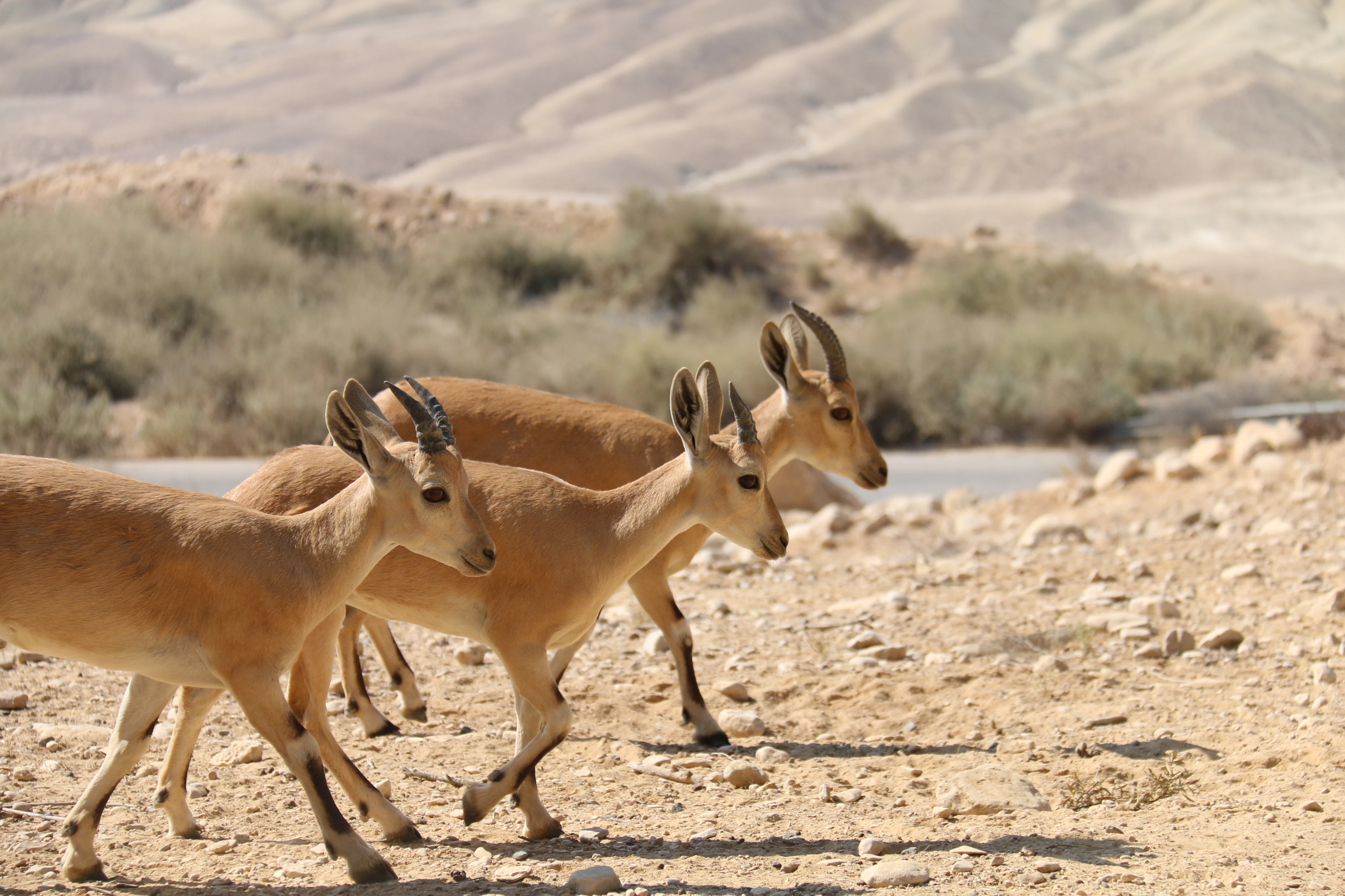
Ibexes walking across rocky terrain with mountains and a body of water in the background.
Ibexes walking along a rocky desert path with a water body visible in the background.

Ein Avdat conservation status and protection priorities

Ein Avdat holds significant conservation value as one of the few permanent desert oasis ecosystems in the Negev region. The springs and their associated riparian habitats represent a rare and fragile environment in an otherwise water-scarce landscape, supporting species assemblages found nowhere else in the Israeli desert. The canyon serves as a critical breeding and nesting site for griffon vultures and Egyptian vultures, both species of conservation concern in the region, making the area important for raptors protection. The park's designation as a National Park of Israel and its administration by the Israel Nature and Parks Authority provide formal protection for both the natural ecosystem and the archaeological heritage within its boundaries. The site's inclusion in the broader Avdat UNESCO World Heritage recognition reflects its international significance as a cultural landscape. However, the park faces inherent challenges related to water scarcity, flash flood events, and visitor pressure, requiring careful management to maintain the ecological balance between allowing access and preserving the sensitive spring ecosystem.

Ein Avdat cultural meaning and human context

The cultural significance of Ein Avdat derives from its exceptional layering of human occupation spanning from prehistoric times through the Nabatean, Roman, Byzantine, and modern periods. The canyon was a significant station along the ancient Incense Route, with Avdat (formerly Eboda) named after the Nabataean King Obodas I, traditionally buried at the nearby city site. The Byzantine monastic presence is particularly remarkable, as monks carved extensive cave complexes into the canyon walls, creating living spaces, storage areas, and religious spaces that remain partially intact today. The Byzantine church at Ein Avdat represents one of the earliest Christian worship sites in the region, predating Constantine's legalization of Christianity. The site embodies the intersection of trade, religion, and settlement that characterized the Negev's historical role as a crossroads between Arabia, Egypt, and the Mediterranean world. The name itself reflects this heritage: 'Ein' means spring in both Hebrew and Arabic, while 'Avdat' derives from the nearby city named after the Nabataean king.

Top sights and standout views in Ein Avdat

Ein Avdat offers visitors a rare combination of natural wonder and historical depth in an unexpected desert setting. The main waterfall and deep pool at the southern springs represent the park's most dramatic natural feature, where water cascades 15 meters into a refreshing pool surrounded by verdant vegetation. The Byzantine cave monastery provides a tangible connection to early Christian monastic life in the desert, with its carved chambers, crosses, and remarkably preserved church. Hiking the canyon trail allows exploration of multiple springs including Ein Ma'arif and Ein Mor, each with distinct character. The opportunity to observe Nubian ibex navigating cliff walls and griffon vultures soaring on thermal currents adds wildlife viewing to the experience. The park's position within the larger Avdat heritage site, recognized by UNESCO, connects it to a broader network of ancient Nabatean and Byzantine settlements in the Negev.

Best time to visit Ein Avdat

The best time to visit Ein Avdat depends on balancing comfortable hiking conditions with the park's seasonal water flow characteristics. Winter months (December through February) bring cooler temperatures that make hiking more pleasant, with January temperatures sometimes dropping to -3.6°C, but this is also the wettest season when flash floods can occur and some trails may be temporarily closed. Summer months (June through August) feature extreme heat with temperatures exceeding 40°C, making midday hiking dangerous and reducing the appeal of the trails despite the full water flow from springs. Spring and autumn offer the most balanced conditions, with moderate temperatures and comfortable hiking weather, though spring may bring the added interest of occasional water flow from winter precipitation. The high humidity near the springs, relative to the surrounding desert, creates a slightly more temperate microclimate. Visitors should check current conditions and potentially avoid visiting during or immediately after heavy rain events given the flash flood risk characteristic of desert wadis.
Monthly climate preview

Analyzing thirty years of historical temperature and dry precipitation patterns across the canyon landscape

Monthly Climate Normals and Average Temperatures for Ein Avdat in Israel

Long-term measurements from the canyon landscape of Ein Avdat show a distinct desert rhythm with hot, dry summer peaks over 40 degrees Celsius and cooler, wetter winter periods. Comparing the complete twelve-month profile reveals detailed historical trends in average temperature ranges and daily precipitation across the protected terrain.
Annual mean20 °C
11 °C28 °C
Jan11°
Feb12°
Mar15°
Apr19°
May23°
Jun26°
Jul28°
Aug28°
Sep26°
Oct23°
Nov18°
Dec13°
Warmest month
August

28.1 °C

Coolest month
January

10.8 °C

Wettest month
January

1.3 mm/day

Driest month
June

0 mm/day

Park location guide

Geography guide, regional context, and park location map for Ein Avdat

Ein Avdat park geography, regions, and map view in Israel

Understand where Ein Avdat sits in Israel through a broader geographic reading of the surrounding landscape, nearby location context, and its mapped position within the national park landscape.

How Ein Avdat fits into Israel

Israel is a parliamentary republic in the Southern Levant, established in 1948 as a Jewish homeland. It borders Lebanon, Syria, Jordan, and Egypt, with Mediterranean coastline and access to the Red Sea. Jerusalem is the capital, though its status is contested, while Tel Aviv is the largest urban area. The country has a high-income economy with strong technology and innovation sectors.

Wider geography shaping Ein Avdat in Israel

Israel occupies the Southern Levant region of West Asia. It is bordered by Lebanon to the north, Syria to the northeast, Jordan to the east, and Egypt to the southwest. The western coast lies on the Mediterranean Sea, while the southern tip reaches the Red Sea. The eastern border includes the Dead Sea, Earth's lowest point. The country occupies the West Bank, Gaza Strip, and Golan Heights.

Map view of Ein Avdat

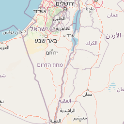
Use this park location map to pinpoint Ein Avdat in Israel, understand its exact geographic position, and read its mapped placement within the surrounding landscape more clearly.

Pigeon | © OpenStreetMap contributors

Location context for Ein Avdat

Negev

Uncover Ein Avdat's Dramatic Desert Canyon Geology, Lush Oasis Habitats, and Ancient Protected Area Views

Ein Avdat National Park: Explore Visual Landscapes, Oasis Scenery, and Canyon Habitats

Explore a comprehensive collection of imagery showcasing Ein Avdat National Park's unique desert canyon, lush oasis landscapes, and distinct natural features. These visual insights offer crucial context, allowing you to trace the park's terrain, understand its spring-fed habitats, and visualize its protected-area character within the Negev Desert.

Wide view of Ein Avdat canyon with rocky terrain, desert valleys, and distant mountains under a clear blue sky

A narrow canyon channel with calm water reflecting layered sandstone cliffs, surrounded by rocky terrain and sparse vegetation

Calm spring water reflecting rocky canyon walls, vegetation, and two people standing at the water's edge under a clear sky.

Rocky canyon with layered cliffs and sparse vegetation under clear sky.

Ibexes walking across rocky terrain with mountains and a body of water in the background.

Muddy water flowing through a deep canyon with rocky walls in Ein Avdat, Israel

Park atlas

Explore adjacent desert canyons, unique oases, and historical protected areas across the wider Negev region, enabling deeper geographic comparison.

Discover More Protected Areas and National Parks Near Ein Avdat in Israel's Negev Desert

After exploring Ein Avdat's unique desert oasis and Byzantine heritage, browse other protected areas, national parks, and ecological reserves situated within the diverse landscapes of Israel's Negev Desert. Compare distinct desert canyons, ancient archaeological sites, and varied conservation efforts to trace the region's natural and historical protected-area geography.
National parkIsrael
About 3.3 km away#1 closest

Northeast

Ben-Gurion Tomb National Park: Protected Desert Landscape and Geographic Context

Explore the Negev Desert's unique memorial terrain.

Ben-Gurion Tomb National Park offers a distinct protected landscape experience in the heart of Israel's Negev Desert. This national park is primarily known as the burial site of David and Paula Ben-Gurion, intentionally situated in the desert overlooking the dramatic Nahal Tzin canyon. The park's approximately 90 dunams feature a carefully designed memorial garden that contrasts with the arid terrain, providing a unique focus for geographic exploration and understanding the site's regional landscape.

Area
0.09 km²
Relief
Lowland
Climate
Arid
Access
Easy access
National parkIsrael
About 3.6 km away#2 closest

South

Avdat National Park: A Protected National Park in Israel's Regional Geography

Mapped landscape context and protected area details for Avdat National Park.

Avdat National Park represents a distinct protected landscape entity within the atlas of Israel. This resource focuses on the park's geographic identity, its mapped boundaries, and the surrounding natural terrain. Delve into the specific protected-area attributes that define Avdat National Park and understand its contribution to the country's conservation geography, offering a grounded perspective for geographic exploration.

Climate
Arid
Scope
Terrestrial
Water
No major water
Forest
No forest cover
National parkIsrael
About 14 km away#3 closest

Northwest

Shivta National Park National Park: An Atlas View of Israel's Protected Landscapes

Mapped terrain and regional geographic context for Shivta National Park.

Shivta National Park represents a key protected area, offering a focused entry into Israel's broader geographic and landscape atlas. This page provides specific details about the park's identity as a national park, its mapped terrain, and its placement within the regional context of the country. Users can explore the structured information that defines Shivta National Park's role as a protected landscape, contributing to a deeper understanding of its geographic significance and mapped features.

Climate
Arid
Access
Easy access
Scope
Terrestrial
Water
No major water
National parkIsrael
About 28 km away#4 closest

South

Makhtesh Ramon National Park: Israel's Premier Erosion Cirque & Geological Wonder

Discover dramatic desert terrain and ancient, colorful rock formations.

Makhtesh Ramon National Park in Israel's Negev Desert is the world's largest erosion cirque, a vast 40-kilometer depression revealing millions of years of geological history. Its striking landscape features colorful clay hills, ancient volcanic remnants, fossil beds, and unique sandstone formations, making it an unparalleled destination for understanding Earth's past through its protected natural terrain. Explore the mapped boundaries and regional context of this extraordinary desert formation.

Relief
Mountain
Climate
Arid
Access
Moderate access
Scope
Terrestrial
Watercolor illustration of rolling green hills, a body of water, and grassy vegetation under a light sky.
National parkIsrael
About 36 km away#5 closest

Northeast

Mamshit National Park: Ancient Nabataean City, Byzantine Ruins, and Negev Desert Landscape

Explore exceptionally preserved Nabataean urban architecture and regional geography.

Mamshit National Park offers a rare window into ancient desert urbanism, preserving an exceptionally intact Nabataean caravan city and Byzantine settlement in Israel's Negev Desert. The site showcases unique residential compounds and religious structures, demonstrating sophisticated architectural traditions and water management systems against a backdrop of striking natural terrain. As a vital component of the Incense Road heritage, Mamshit provides rich context for understanding ancient trade, regional geography, and the enduring human adaptation to arid landscapes.

IUCN
V
Relief
Lowland
Climate
Arid
Scope
Terrestrial
National parkIsrael
About 47 km away#6 closest

North

Tel Be'er Sheva National Park: Mapped Boundaries and Protected Landscape Identity

Discover its geographic context within Israel's natural terrain.

This MoriAtlas detail page for Tel Be'er Sheva National Park provides focused insights into its identity as a protected landscape. Users can explore its specific geographic setting within Israel, understand its mapped boundaries, and gain a clearer appreciation for its natural terrain. The content is designed to support detailed atlas-based discovery, offering a comprehensive view of the park's protected area characteristics and regional geographic significance.

Watercolor illustration showing a winding river through green hills with distant trees under a light sky
National parkIsrael
About 60 km away#7 closest

Northwest

Eshkol National Park: Desert Wetland Oasis with Archaeological Significance in Southern Israel

Mapped protected area featuring Ein HaBesor spring and Besor valley landscapes.

Eshkol National Park showcases a rare desert wetland environment sustained by the significant Ein HaBesor spring in Israel's Northern Negev. This protected natural area offers a distinctive landscape where water nourishes lush vegetation against the backdrop of arid terrain. Beyond its ecological value, the park encompasses archaeological remnants, including the mound of Khirbet Shalala, providing a rich geographical and historical discovery context within the Besor Stream basin.

Area
3.54 km²
Relief
Lowland
Climate
Arid
Access
Easy access
Nature reserveJordan
About 60 km away#8 closest

East

Fifa Nature Reserve Nature Reserve: Protected Landscape Discovery in Jordan

Mapped natural terrain and protected area context.

Fifa Nature Reserve represents a distinct protected natural landscape within Jordan. This entry offers users a detailed atlas-style view of the reserve's protected boundaries and its place within the country's geography. Explore the mapped terrain and understand the significance of this nature reserve for structured geographic discovery and protected-area research.

Area
23.2 km²
Established
2011
Relief
Lowland
Climate
Arid

Common questions about visiting, size, designation, and location context for Ein Avdat

Ein Avdat FAQs for park facts, access, geography, and protected area context

Find quick answers about Ein Avdat, including protected-area facts, park geography, trail and visitor context, and how the park fits into its surrounding country and regional landscape.
MoriAtlas Explorer

Continue Your Protected Areas Search Across the Global Atlas

Deepen your exploration by continuing the structured search for national parks and protected areas worldwide. Utilize the comprehensive filtering capabilities to compare different conservation landscapes and refine your understanding of global park geography. Discover more about the distribution and characteristics of protected natural areas.

Global natural geography