Mori Atlas logo
National parkEl Tuparro National Natural Park

Discover the mapped geography and unique natural terrain of this Orinoco basin conservation area.

El Tuparro National Natural Park: Exploring Colombia's Tropical Savanna Protected Landscape in Vichada

(Parque Nacional Natural El Tuparro)

El Tuparro National Natural Park represents a crucial protected landscape within Colombia's Vichada Department, safeguarding a rare example of the Llanos Orientales tropical savanna. This vast national park offers a unique atlas perspective on riparian forests, river rapids along the Orinoco River, and expansive plains. Users can explore its mapped boundaries and understand its significant regional geographic context and ecological importance within South America.

Tropical SavannaRiparian ForestRiver RapidsLlanos OrientalesWildlife ViewingOrinoco Basin

El Tuparro National Natural Park

National park

Park overview

Structured park overview, official facts, and landscape profile for El Tuparro National Natural Park

El Tuparro National Natural Park park facts, protected area profile, and essential visitor context

Review the core facts for El Tuparro National Natural Park, including designation, size, terrain, visitor scale, habitats, and operating context in one park-focused overview.

About El Tuparro National Natural Park

El Tuparro National Natural Park stands as a testament to Colombia's commitment to preserving its natural heritage within the Orinoquía, one of the nation's most ecologically significant bioregions. The protected area occupies a strategic position in the eastern Colombian plains, where the infinite horizontal horizons of tropical savanna create one of the continent's most recognizable landscapes. The park's boundaries are naturally defined by three major river systems: the Orinoco, Colombia's largest river, forms the eastern frontier; the Tomo River marks the northern limit; and the Tuparro River traces the southern edge. This riverine framing not only provides ecological connectivity but also shapes the park's character, with riparian forests serving as vital green corridors through the otherwise open terrain. The park's establishment in 1970 marked a critical milestone in Colombian conservation, as it became the sole protected representation of the Llanos Orientales ecosystem within the national parks system. The region has long captured scientific attention, with Alexander von Humboldt's exploration of the Maipures Rapids in the 1800s establishing the site's international reputation. Beyond its ecological significance, the park contains archaeological importance, preserving evidence of pre-Columbian human occupation throughout its territory.

Quick facts and research context for El Tuparro National Natural Park

El Tuparro National Natural Park lies in the Vichada Department of eastern Colombia, spanning the Orinoquía Region's characteristic flat savanna landscapes. The park was established in 1970 and covers 548,000 hectares, making it one of Colombia's largest protected areas. It is bounded by the Orinoco River to the east, the Tomo River to the north, and the Tuparro River to the south. Average temperatures hover around 27°C, with annual rainfall ranging from approximately 2,477 mm in western areas to 2,939 mm near the Orinoco. Savannas dominate roughly 75% of the park's terrain, with gallery forests lining the river corridors. The park falls under IUCN Category II protection and is managed by Colombia's National System of Protected Areas (SINAP).

Protection and recognition

Verifying official conservation frameworks and terrestrial management boundaries for the park

Documented Protection Status and Terrestrial Designation of El Tuparro National Natural Park

Exploring the official terrestrial classification of El Tuparro National Natural Park reveals its registered status within national conservation frameworks. Map records and registered data points clarify how the designated land boundary aligns with global protective standards to support transparent regional discovery.

Protection details

Protection scope
Terrestrial
Transboundary protection
No
Park context

Deeper park guide and search-rich context for El Tuparro National Natural Park

El Tuparro National Natural Park history, landscape, wildlife, and travel context

Explore El Tuparro National Natural Park through its history, landscape character, ecosystems, wildlife, conservation priorities, cultural context, and seasonal travel timing in a structured park guide built for atlas discovery and search intent.

Why El Tuparro National Natural Park stands out

El Tuparro is most renowned for the spectacular Raudal de Maypures (Maipures Rapids), a dramatic whitewater stretch along the Orinoco River that German explorer Alexander von Humboldt famously dubbed the "Eighth Wonder of the World" during his 19th-century expedition through South America. Beyond this legendary rapid, the park is distinguished by its representation of the intact Llanos Orientales ecosystem, a vast tropical savanna environment that has remained relatively undisturbed compared to other lowland regions. The park's riparian forests, characterized by towering Moriche Palm groves and the distinctive Caraipa llanorum tree, create a striking visual contrast against the open savannas and provide critical habitat for diverse wildlife populations.

El Tuparro National Natural Park history and protected-area timeline

El Tuparro National Natural Park was established in 1970, representing Colombia's effort to protect the unique ecosystems of the Orinoquía region. The creation of this protected area filled a critical gap in the national conservation system, as the Eastern Plains (Llanos Orientales) had previously lacked formal protection despite their ecological significance. The park was integrated into Colombia's National System of Protected Areas (SINAP), which coordinates conservation efforts across the country's diverse biomes. The selection of the area for protection was influenced by its outstanding natural features, including the dramatic Maipures Rapids that had attracted scientific curiosity since the 19th century, when Alexander von Humboldt documented the site and bestowed upon it the title of "Eighth Wonder of the World." The park's establishment also recognized the region's cultural significance, with archaeological evidence indicating human occupation of the area long before European colonization.

El Tuparro National Natural Park landscape and geographic character

The landscape of El Tuparro National Natural Park is defined by the quintessential flat terrain of the Orinoquía, where elevation changes are barely perceptible across vast distances. The park's topography is characterized by extensive savanna plains that stretch to the horizon, interrupted only by the distinctive green ribbons of gallery forests that follow river courses. These riparian forests form natural corridors through the grassland, creating a mosaic of habitats that defines the park's visual character. The three rivers that bound and traverse the area—the Orinoco, Tomo, and Tuparro—provide essential hydrological functions and create diverse aquatic environments. The Maipures Rapids, located along the Orinoco River within the park, represent a dramatic geological feature where the river's course encounters resistance, creating powerful rapids that have long captured human imagination. The landscape supports two primary savanna types: seasonally flooded savannas that transform into temporary wetlands during rainy periods, and non-flooded savannas that maintain more consistent ground conditions. This hydrological variation contributes to the park's ecological complexity.

El Tuparro National Natural Park ecosystems, habitats, and plant life

The nature of El Tuparro reflects the distinctive ecological character of the Colombian Orinoquía, where tropical savanna ecosystems support remarkable biodiversity despite seasonal environmental extremes. The park's vegetation follows a clear pattern, with open savannas covering approximately 75% of the terrain while gallery forests occupy the remaining area along water courses. The Moriche Palm (Mauritia flexuosa) dominates much of the riparian vegetation, forming iconic stands that provide food and habitat for numerous species. The tree Caraipa llanorum represents another characteristic species of the gallery forests. The flooded savannas experience seasonal water inundation that transforms the grassland into extensive wetlands, creating critical habitat for aquatic species and migratory waterbirds. The non-flooded savannas support drought-resistant grasses that persist through the dry season. This ecosystem diversity supports the park's impressive species counts, including 74 mammal species, 320 bird species, 17 reptile species, 26 fish species, and five primate species. The amphibian population is particularly notable given the variety of aquatic and terrestrial habitats present.

El Tuparro National Natural Park wildlife and species highlights

El Tuparro National Natural Park supports impressive wildlife populations across its diverse habitats, with the savanna and forest environments each hosting distinctive species assemblages. The avifauna is particularly diverse, with 320 species documented including guans, curassows, screamers, eagles, and various duck species. These birds utilize the full range of park habitats, from the open savannas to the forest canopy and river channels. Mammalian fauna includes notable species such as the white-tailed deer, giant armadillo, and the large tapir, which inhabits the woodland areas. The park's forested environments support populations of peccaries, pumas, and jaguars, representing the apex predators of the Orinoquía ecosystem. Five primate species are recorded within the park, reflecting the tropical character of the gallery forests. The rivers contain 26 fish species, while 17 reptile species including various snakes and caimans utilize both aquatic and terrestrial habitats. The seasonal flooding of the savannas creates dynamic conditions that influence wildlife distribution and behavior throughout the year.

El Tuparro National Natural Park conservation status and protection priorities

El Tuparro National Natural Park holds significant conservation importance as the only protected area representing the Eastern Plains (Llanos Orientales) within Colombia's National Natural Parks System. This designation makes the park irreplaceable for conservation of the Orinoquía's characteristic ecosystems, which have experienced extensive transformation in surrounding areas for agriculture and cattle ranching. The park protects critical habitat for species including jaguars, pumas, giant armadillos, and tapirs, all of which require large territories and intact habitat corridors. The gallery forests serve as essential refuges and movement pathways for forest-dependent species navigating the otherwise open savanna landscape. The protected status also preserves the Maipures Rapids and their cultural significance, ensuring that this natural wonder remains unimpaired. As an IUCN Category II protected area, the park aims to protect natural ecosystems while allowing for sustainable scientific research, environmental education, and limited visitation that does not compromise conservation objectives.

El Tuparro National Natural Park cultural meaning and human context

The El Tuparro region holds cultural significance extending beyond its ecological value, with archaeological evidence indicating long-term human occupation of the area before European contact. The Maipures Rapids have historical importance as a landmark along the Orinoco River, a major transportation corridor for indigenous peoples and later colonial explorers. The gallery forests and river systems historically supported indigenous communities who utilized the diverse resources provided by these ecosystems. Alexander von Humboldt's visit in the 19th century brought international scientific attention to the region, with his descriptions of the Maipures Rapids helping to establish the site's enduring reputation. The park's name derives from the Tuparro River that forms its southern boundary, reflecting the geographical framing that has long characterized this area of the Orinoquía.

Top sights and standout views in El Tuparro National Natural Park

El Tuparro National Natural Park offers visitors access to one of South America's most iconic natural landscapes, where the vast savannas of the Llanos Orientales meet the powerful currents of the Orinoco River at the Maipures Rapids. The park provides exceptional opportunities to observe wildlife in relatively undisturbed tropical savanna environments, with jaguars, pumas, tapirs, and giant armadillos among the notable species present. The gallery forests, with their towering Moriche Palms, create striking visual contrast against the open grasslands and offer excellent birdwatching opportunities for species including guans, curassows, and eagles. The seasonal flooding of the savannas transforms the landscape dramatically between wet and dry seasons, each offering distinct viewing experiences. The park represents a unique conservation opportunity as the sole protected representation of the Colombian Eastern Plains ecosystem within the national parks system.

Best time to visit El Tuparro National Natural Park

The optimal time to visit El Tuparro National Natural Park depends on the experience sought, with the dry season typically offering more accessible wildlife viewing in the open savannas while the wet season reveals the transformed flooded grassland environment. The average temperature remains consistently around 27°C throughout the year, but rainfall varies significantly between the western portion of the park (approximately 2,477 mm annually) and eastern areas near the Orinoco (approximately 2,939 mm). The wet season generally runs from April to November, when the savannas become temporary wetlands and river levels rise dramatically, sometimes affecting access to certain areas. The dry season from December through March concentrates wildlife around remaining water sources and can offer clearer conditions for exploring the landscape. Visitors interested in experiencing the full spectrum of the park's ecological dynamics may find value in visiting during transition periods.

Monthly climate preview

Analyzing long-term average temperature and precipitation cycles in Vichada Department

Climate Profile and Monthly Weather Normals for El Tuparro National Natural Park

Long-term measurements show hot, dry conditions early in the year, with average maximum temperatures approaching forty degrees Celsius, followed by a shift to high-precipitation months mid-year. Exploring the complete monthly database helps map the distinct climate-normal profile of El Tuparro National Natural Park.
Annual mean27 °C
25 °C30 °C
Jan27°
Feb29°
Mar30°
Apr28°
May27°
Jun26°
Jul25°
Aug26°
Sep26°
Oct26°
Nov26°
Dec26°
Warmest month
March

29.7 °C

Coolest month
July

25.4 °C

Wettest month
June

12.9 mm/day

Driest month
January

0.6 mm/day

Park location guide

Geography guide, regional context, and park location map for El Tuparro National Natural Park

El Tuparro National Natural Park park geography, regions, and map view in Colombia

Understand where El Tuparro National Natural Park sits in Colombia through a broader geographic reading of the surrounding landscape, nearby location context, and its mapped position within the national park landscape.

How El Tuparro National Natural Park fits into Colombia

Colombia is a presidential republic located in the northern part of South America. It spans approximately 1.14 million km² and has a population of around 52 million. The country features the Andes mountain range, extensive Amazon rainforest, and coastal regions on both the Caribbean and Pacific. Spanish is the official language, and Bogotá serves as the capital and largest city.

Wider geography shaping El Tuparro National Natural Park in Colombia

Colombia is located in the northwestern part of South America, bordering the Caribbean Sea to the north and the Pacific Ocean to the west. Its mainland neighbors are Venezuela to the east, Brazil to the southeast, Peru and Ecuador to the south and southwest, and Panama to the northwest. The terrain is diverse, featuring the Andes mountain range in the west, Amazon rainforest in the south and east, and coastal plains along both oceans.

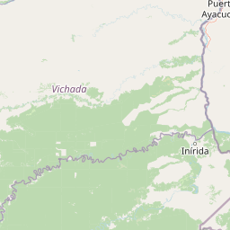
Map view of El Tuparro National Natural Park

Use this park location map to pinpoint El Tuparro National Natural Park in Colombia, understand its exact geographic position, and read its mapped placement within the surrounding landscape more clearly.

Pigeon | © OpenStreetMap contributors

Location context for El Tuparro National Natural Park

Orinoquía RegionVichada Department
Park atlas

Uncover the geographic context and connected protected areas of the Orinoquía Region, comparing varied conservation landscapes.

Explore National Parks and Protected Areas Near El Tuparro National Natural Park, Colombia

After exploring El Tuparro National Natural Park, broaden your discovery by browsing other national parks and protected areas across Colombia's Orinoquía Region and the wider Orinoco Basin. Compare diverse conservation landscapes, map regional park geography, and understand the ecological spread of tropical savannas and riparian forests in their broader geographic context.
Natural monumentAmazonas
33 km away#1 closest

Northeast

Monumento natural Piedra la Tortuga: Granite Outcrops and Archaeological Landscapes

A vital protected monument in the Amazonas region of Venezuela

Discover the geological significance of Monumento natural Piedra la Tortuga, where ancient Precambrian granite formations rise above tropical savannas and gallery forests. This protected area preserves a unique concentration of indigenous history, including major petroglyphs and burial sites, while supporting diverse bird species and riparian ecosystems within the Amazonas region.

Area
5.03 km²
Established
1992
Relief
Upland
Climate
Tropical
National parkApure State
About 150 km away#2 closest

North

Santos Luzardo National Park: Exploring Venezuela's Protected Landscape Geography

National park mapped boundaries and regional natural terrain.

This detailed entry for Santos Luzardo National Park focuses on its role as a national park and its contribution to the geographic atlas of Venezuela. It highlights the park's protected landscape, mapped terrain, and its specific setting within Apure State. Engage with concrete details that illuminate the park's protected status and its natural geographic features, perfect for atlas-driven exploration and understanding protected areas.

Area
5,844 km²
Established
1988
IUCN
II
Relief
Lowland
National parkAmazonas
153 km away#3 closest

Southeast

Yapacana National Park: Ancient Geology and Botanical Significance in Venezuela's Amazonas

Discover the dramatic plateau landscapes and unique flora of this protected national park.

Delve into the distinct geography and protected landscape identity of Yapacana National Park, a significant national park within Venezuela's Amazonas region. This page serves as a comprehensive atlas entry, detailing the park's core features, including its iconic Yapacana hill, a dramatic tepui formation representative of the ancient Guayana Shield. Understand the park's geological heritage and its exceptional botanical value, marked by unique floristic connections, all within the context of its Amazonian basin setting.

Area
3,200 km²
Established
1978
IUCN
II
Relief
Highland
Natural monumentVenezuela
About 199 km away#4 closest

East

Monumento Natural Formaciones de Tepuyes: Protected Landscapes and Geological Map

Ancient tepuy table-top mountains in the Venezuelan Guayana Shield

Monumento Natural Formaciones de Tepuyes spans over one million hectares, safeguarding extraordinary geological formations defined by sheer vertical escarpments and flat-topped summits. As a vital protected area within the Guayana Shield, the site offers an essential view into isolated highland geography, endemic ecosystems, and the contrast between ancient mountain plateaus and tropical forest lowlands.

Area
10,698.2 km²
Established
1991
Relief
Mountain
Climate
Tropical
National parkGuainía Department
224 km away#5 closest

South

Puinawai Natural Reserve National Park: Mapped Protected Landscape in Guainía Department

Explore exceptional Amazonian biodiversity and pristine natural terrain.

Puinawai Natural Reserve is a sprawling national park situated in the remote Guainía Department of Colombia. As one of the largest and most ecologically intact protected areas in the Amazon basin, it preserves a unique mosaic of humid tropical rainforest, tropical open savanna, and transitional zones. The park's immense size and isolation contribute to its remarkable state of preservation, offering a significant opportunity for atlas-driven discovery of its mapped boundaries, diverse ecosystems, and complex hydrological geography at the Amazon-Orinoco divide.

Area
10,925 km²
Established
1989
IUCN
II
Relief
Lowland
Wildlife reserveApure
About 226 km away#6 closest

Northwest

Hato El Cedral Wildlife Reserve and Apure Regional Wetland Landscape Geography

Mapping the seasonal plains and riverine corridors of the Venezuelan Llanos.

Hato El Cedral encompasses a vast mosaic of savanna, gallery forest, and seasonally flooded wetlands within the Apure state of Venezuela. This wildlife reserve functions as a critical sanctuary for biodiversity, characterized by its dramatic shifts between dry-season grasslands and wet-season lagoons. Our atlas view provides a detailed context for understanding the reserve's protected boundaries, its river-driven ecosystem, and its unique role in the geography of the Venezuelan Llanos.

Area
530 km²
Established
1987
Relief
Lowland
Climate
Tropical
Wildlife reserveApure
About 253 km away#7 closest

North

Hato El Frío Wildlife Reserve: A Mapped Analysis of Apure's Protected Savanna Landscapes

Examining the ecological boundaries and seasonal wetlands of the Venezuelan llanos

Hato El Frío represents a rare convergence of traditional ranching culture and critical wildlife conservation. Spanning roughly 60,000 hectares, the reserve provides a structured look at the complex hydrological cycles of the Apure plains, where gallery forests and open lagoons support significant biodiversity. This overview offers insights into the regional geography, landscape transformation, and protected status of this enduring Venezuelan landmark.

Area
600 km²
Established
1989
Relief
Lowland
Climate
Tropical
National parkAmazonas
267 km away#8 closest

Southeast

Parque nacional Duida-Marahuaca: Geographic Overview of Protected Tepui Landscapes in Venezuela

Mapping the highland ecosystems and river systems of Amazonas

Parque nacional Duida-Marahuaca protects a vast expanse of remote wilderness, anchored by the prominent Cerro Duida, Cerro Huachamacari, and Cerro Marahuaca. This site offers deep insights into the park's sandstone topography and hydrological connectivity within the broader Guayana Shield, providing a clear geographic understanding of these isolated table-top mesas and their surrounding forest habitats.

Area
2,100 km²
Established
1978
IUCN
II
Relief
Mountain

Common questions about visiting, size, designation, and location context for El Tuparro National Natural Park

El Tuparro National Natural Park FAQs for park facts, access, geography, and protected area context

Find quick answers about El Tuparro National Natural Park, including protected-area facts, park geography, trail and visitor context, and how the park fits into its surrounding country and regional landscape.
MoriAtlas Explorer

Continue Your Protected Areas Search Across the Global Atlas

Deepen your exploration by continuing the structured search for national parks and protected areas worldwide. Utilize the comprehensive filtering capabilities to compare different conservation landscapes and refine your understanding of global park geography. Discover more about the distribution and characteristics of protected natural areas.

Global natural geography