Mori Atlas logo
National parkElijio Panti National Park

Discover the mapped boundaries and regional geographic context of Elijio Panti National Park.

Elijio Panti National Park: Belize National Park Geography and Protected Landscape Atlas

Elijio Panti National Park represents a key protected national park within Belize, situated in the Cayo District. This page focuses on its distinct geographic identity, offering insights into its mapped boundaries and the surrounding natural landscape context. Explore its role as a protected area and understand its position within the broader atlas of natural landscapes in the region.

Mountain parksWaterfall destinationsMaya heritage sitesCommunity conservationCave systemsWildlife habitat

Elijio Panti National Park

National park

Park overview

Structured park overview, official facts, and landscape profile for Elijio Panti National Park

Elijio Panti National Park park facts, protected area profile, and essential visitor context
Review the core facts for Elijio Panti National Park, including designation, size, terrain, visitor scale, habitats, and operating context in one park-focused overview.

About Elijio Panti National Park

Elijio Panti National Park occupies a striking mountainous landscape in western Belize, within the Cayo District's buffer zone communities that surround the Mountain Pine Ridge Reserve. The terrain features rugged slopes, deep valleys, and an impressive network of waterfalls that cascade into natural pools, creating one of the most scenic wilderness areas in Belize's interior. The park's cave systems hold particular archaeological significance, having served as sacred sites for Maya ceremonial practices including sacrificial offerings. Beyond its natural beauty, the protected area embodies a profound cultural legacy, named in honor of Dr. Elijio Panti, the last great Maya master healer in Belize, who spent decades collecting medicinal plants from these forests to treat ailments affecting communities throughout the country. The park's establishment in 2001 marked the culmination of a grassroots movement beginning in 1998 when residents of San Antonio village sought official protection for their surrounding lands, forming the Itzamna Society to advocate for conservation and cultural preservation. The area remains managed with input from local communities who view the park as essential to protecting both their natural environment and their connection to Maya heritage and traditional knowledge.

Quick facts and research context for Elijio Panti National Park

Elijio Panti National Park covers 5,264.5 hectares (13,009 acres) of mountainous terrain in western Belize's Cayo District, within the buffer zones of Cristo Rey, San Antonio, and El Progresso villages. The park was legally established on February 23, 2001, signed into law by the Government of Belize following years of community organizing led by the Itzamna Society. The protected area features dramatic waterfalls including the notable Sakt'aj Waterfall, numerous natural swimming pools, medicinal plant trails historically used by Dr. Elijio Panti, and cave systems that served ancient Maya ceremonial purposes. The area supports diverse wildlife including jaguars, pumas, ocelots, monkeys, and anteaters, contributing to Belize's broader biodiversity significance.

Park context

Deeper park guide and search-rich context for Elijio Panti National Park

Elijio Panti National Park history, landscape, wildlife, and travel context
Explore Elijio Panti National Park through its history, landscape character, ecosystems, wildlife, conservation priorities, cultural context, and seasonal travel timing in a structured park guide built for atlas discovery and search intent.

Why Elijio Panti National Park stands out

Elijio Panti National Park is best known for its dramatic mountain landscape featuring spectacular waterfalls and natural pools set within dense tropical forest. The park preserves an extensive cave system of archaeological significance where ancient Maya communities conducted ritual activities and sacrificial ceremonies. It holds exceptional cultural importance as a living memorial to Dr. Elijio Panti, the legendary Maya healer whose knowledge of traditional medicinal plants drew patients from across Belize and beyond. The park also exemplifies community-driven conservation, created through the collective initiative of local villages working through the Itzamna Society to protect their ancestral lands and natural resources.

Elijio Panti National Park history and protected-area timeline

The establishment of Elijio Panti National Park emerged from a grassroots movement initiated in 1998 when residents of San Antonio village, concerned about accelerating deforestation and land degradation, requested assistance from Belize's Minister of Agriculture to create an official protected area. Local leaders formed a committee headed by María García, which subsequently established a board of governors representing the three buffer zone communities of Cristo Rey, San Antonio, and El Progresso. This body evolved into the Itzamna Society, named for the Maya creator deity, dedicated to environmental protection, cultural preservation, and community development. During 1999, the Itzamna Society negotiated with the Belizean government to secure official land tenure for the proposed park, receiving support from organizations including Help for Progress, the Cockscomb Basin Wildlife Sanctuary, and government agencies such as the Protected Areas Conservation Trust. The Itzamna Society achieved formal NGO registration on February 9, 2000, and the reserve was officially designated as Elijio Panti National Park on February 23, 2001, named in honor of Dr. Elijio Panti who had died in 1996 at age 103. Following establishment, a comprehensive management plan was developed and training programs initiated for local residents. Plans were also advanced to explore declaration of an additional 30,000 acres for preservation of Mayan medicinal plants, endangered species conservation, and scientific research.

Elijio Panti National Park landscape and geographic character

Elijio Panti National Park features a dramatic mountainous landscape characterized by steep ridges, deep valleys, and an intricate network of streams cascading over rocky outcrops to form waterfalls and natural swimming pools. The terrain rises significantly within the park's boundaries, creating varied microclimates and exposure across different elevations. The most celebrated waterfall within the park is Sakt'aj, which draws visitors seeking to experience the scenic beauty of this tropical mountain environment. The underlying geology supports numerous caves and karst formations that penetrate the mountainous terrain, many of which hold archaeological significance from Maya occupation. The landscape transitions through different vegetation types as elevation changes, with the higher elevations featuring pine elements connected to the Mountain Pine Ridge ecosystem while lower slopes support tropical broadleaf forest. This varied topography creates visual diversity and supports the ecological complexity that makes the park significant for biodiversity conservation.

Elijio Panti National Park ecosystems, habitats, and plant life

The park's ecological character reflects its position within Belize's interior highlands, where tropical forest ecosystems transition into more pine-dominated communities characteristic of the Mountain Pine Ridge. The vegetation includes both broadleaf tropical species and pine elements, creating a diverse forest structure that supports numerous ecological niches. The park contains significant populations of medicinal plants that were historically documented by Dr. Elijio Panti, whose traditional knowledge shaped the creation of designated medicinal trails within the protected area. These plant communities contribute to the broader biodiversity of the region, which is recognized as one of the most biologically diverse in Central America. The forest provides essential habitat connectivity linking the park to surrounding protected areas, supporting ecological processes that sustain wildlife populations across the larger landscape.

Elijio Panti National Park wildlife and species highlights

Elijio Panti National Park supports a notable diversity of wildlife within its mountainous forest habitats, including several species of significant conservation concern. The park provides habitat for jaguar, puma, and ocelot, representing the trio of large Neotropical cats that roam Belize's forests. These apex predators require extensive territory and intact habitat corridors, making protected areas like Elijio Panti essential for their persistence in the region. The mammal community also includes various monkey species and anteaters, contributing to the park's reputation as a destination for wildlife observation. The forest canopy supports rich birdlife, making the park suitable for birdwatching activities. The combination of diverse habitats from valley bottoms to ridgelines creates conditions supporting this wildlife assemblage, though the specific species inventories remain less comprehensively documented than in some neighboring protected areas.

Elijio Panti National Park conservation status and protection priorities

Elijio Panti National Park contributes to Belize's protected areas network as an IUCN Category II designation, representing national park status focused on ecosystem conservation and visitor enjoyment. The park plays a crucial role in watershed protection for the surrounding communities, with its forested slopes regulating water flow and maintaining water quality in streams that communities depend upon. The protected area also supports conservation of Maya cultural heritage, particularly traditional medicinal plant knowledge associated with Dr. Elijio Panti, which the park preserves as part of Belize's intangible cultural legacy. The park was established through a community-based conservation model that demonstrates how local initiatives can achieve formal protection status, providing a precedent for similar efforts in Belize and Central America. The cave systems within the park require specific management attention to protect archaeological values while allowing appropriate educational access.

Elijio Panti National Park cultural meaning and human context

The park's identity is deeply intertwined with Maya cultural heritage, both through its archaeological features and its naming for Dr. Elijio Panti, the revered Maya healer whose life and traditional knowledge shaped the region's understanding of indigenous medical practice. Dr. Panti was widely recognized as the last great Maya master healer in Belize, possessing extensive knowledge of medicinal plants that he collected from the forests now within the park's boundaries. Patients traveled from across Belize and beyond to seek his treatments, and his reputation extended throughout the region. The park preserves trails where he historically harvested medicinal plants, maintaining a physical connection to this traditional knowledge. The cave systems within the park hold additional cultural significance as sites where ancient Maya conducted ceremonial activities, including ritual offerings that archaeologists have documented. The community-driven establishment of the park reflects continuing traditions of collective land stewardship among the villages surrounding the protected area.

Top sights and standout views in Elijio Panti National Park

The park's most distinctive features include the spectacular Sakt'aj Waterfall and network of natural swimming pools that provide scenic recreational opportunities within a protected wilderness setting. The extensive cave system represents a major highlight for visitors interested in Maya archaeology and the ceremonial history of the region. The preserved medicinal trails offer a unique opportunity to experience landscapes associated with traditional Maya healing practices, linking natural environment to cultural heritage. Wildlife viewing opportunities, particularly for jaguar, puma, and other forest species, attract visitors interested in Neotropical fauna. The combination of natural beauty, cultural significance, and community-led conservation creates a distinctive protected area that represents both Belize's ecological wealth and its living Maya traditions.

Best time to visit Elijio Panti National Park

Elijio Panti National Park can be visited throughout the year, though the dry season from December through April typically offers more comfortable conditions for outdoor activities and hiking. During this period, reduced rainfall means trail conditions are generally more stable and wildlife viewing may be more predictable as animals concentrate around remaining water sources. The wet season from May through November brings heavier rainfall that can affect trail accessibility and create challenging conditions for activities like tubing. However, the wet season also transforms the landscape with lush vegetation and fuller waterfalls, offering a different but equally compelling experience. Visitors should be prepared for Belize's tropical climate regardless of season and should check current conditions with local operators before planning activities.

Park location guide

Geography guide, regional context, and park location map for Elijio Panti National Park

Elijio Panti National Park park geography, regions, and map view in Belize
Understand where Elijio Panti National Park sits in Belize through a broader geographic reading of the surrounding landscape, nearby location context, and its mapped position within the national park landscape.

How Elijio Panti National Park fits into Belize

Belize is a Caribbean and Central American nation located on the Yucatán Peninsula's eastern coast. It gained independence from Britain in 1981 and remains a Commonwealth realm with Charles III as monarch. The country features diverse cultures, multiple spoken languages including Belizean Creole, Spanish, and Mayan languages, and is recognized for its rich marine biodiversity including the Mesoamerican Barrier Reef.

Wider geography shaping Elijio Panti National Park in Belize

Belize occupies the eastern coast of the Yucatán Peninsula, stretching approximately 290 kilometres long and 110 kilometres wide. It is bordered by Mexico to the north and west, Guatemala to the south and west, and the Caribbean Sea to the east. The country also shares a maritime boundary with Honduras. The landscape includes coastal plains, swamps, and the Maya Mountains in the interior.

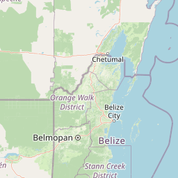
Map view of Elijio Panti National Park

Use this park location map to pinpoint Elijio Panti National Park in Belize, understand its exact geographic position, and read its mapped placement within the surrounding landscape more clearly.

Pigeon | © OpenStreetMap contributors

Location context for Elijio Panti National Park

Cayo District
Park atlas

Explore surrounding protected landscapes, comparing park geography and regional context across Belize's Cayo District.

Discover Other National Parks and Protected Areas Near Elijio Panti National Park in Belize
After exploring Elijio Panti National Park's mountainous terrain and Maya heritage, browse other national parks and protected areas across Belize, tracing their geographic spread and conservation profiles. This enables deeper comparison of adjacent wilderness, waterfall destinations, and cave systems, enriching your understanding of Central American protected landscapes.
National parkCayo District

Chiquibul National Park: Detailed Protected Area and National Park Geography

Explore mapped boundaries within Belize's Cayo District.

Chiquibul National Park offers a critical lens through which to view Belize's protected natural areas. As a designated national park located in the Cayo District, it provides essential data for understanding the extent and geographic positioning of conservation landscapes. Users can engage with detailed map information to trace the park's borders and appreciate its role within the national atlas of protected territories.

Area
1,073 km²
Established
1995
IUCN
II
Relief
Mountain
National parkCayo District

Guanacaste National Park National Park: Explore its Protected Landscape and Geographic Setting

Mapped natural terrain and regional context within Cayo District.

Delve into the specifics of Guanacaste National Park, a protected national park located in the Cayo District of Belize. This detail page is designed for atlas exploration, offering insights into the park's geographic boundaries and its significance as a defined natural landscape. Understand how this protected area fits into the regional geography and contributes to the mapped natural heritage of Belize.

Area
0.2 km²
Established
1973
IUCN
II
Climate
Tropical
National parkCayo District

St. Herman's Blue Hole National Park: National Park Protected Landscape and Geographic Setting

Mapped Boundaries and Regional Landscape Context in Cayo District

St. Herman's Blue Hole National Park is an integral protected landscape within Belize, situated in the Cayo District. This national park offers specific geographic features and mapped boundaries essential for understanding its place within regional conservation. MoriAtlas provides detailed context for exploring the park's protected terrain and its contribution to the broader geographic atlas, focusing on landscape identity and mapped outlines for analytical discovery.

Area
2 km²
Established
1986
Climate
Tropical
Access
Easy access
National parkToledo District

Payne's Creek National Park: National Park Protected Landscape and Geographic Atlas

Explore mapped boundaries and regional geography in Toledo District.

Payne's Creek National Park serves as a vital protected area within Belize, recognized as a national park. This entry details its specific location within the Toledo District, emphasizing the mapped extent of its protected boundaries. It provides a foundation for understanding the park's geographic character and its role within regional conservation landscapes, ideal for atlas-based discovery.

Area
152 km²
IUCN
II
Relief
Lowland
Climate
Tropical
National parkToledo District

Sarstoon-Temash National Park: National Park Geography and Mapped Boundaries

Explore the protected landscape of Toledo District.

Sarstoon-Temash National Park is a key protected area located in Belize's Toledo District. As a national park, it offers distinct geographic features and mapped boundaries that are crucial for understanding regional conservation landscapes. This entry provides detailed context on its protected status and geographic setting, enabling a more profound atlas-based exploration of the natural terrain and its significance.

Area
165.92 km²
Established
1994
IUCN
II
Relief
Lowland
National parkPetén

El Rosario National Park: Protected National Park & Mapped Landscape Explorer

Geographic context and protected area boundaries within Petén.

Delve into the protected landscape of El Rosario National Park, identified as a national park within Guatemala's Petén region. This page provides an atlas-centric view, highlighting its mapped park boundaries and its significance in the regional geography. Understand the park as a distinct protected area contributing to the natural landscape context, ideal for geographic exploration and detailed mapping.

Area
11.05 km²
Established
1980
IUCN
II
Relief
Lowland
National parkAmbergris Caye

Bacalar Chico National Park and Marine Reserve: Belize National Park & Marine Reserve Atlas

Explore Ambergris Caye's unique barrier island and reef geography.

Discover the extensive protected territory of Bacalar Chico National Park and Marine Reserve, a critical national park and marine reserve situated on Ambergris Caye, Belize. This protected area showcases a rich diversity of landscapes, from rare littoral forests and inland wetlands to vital coral reefs and sea grass beds integral to the Mesoamerican Barrier Reef System. Its unique geographic position and ecological significance make it a key destination for understanding Belize's conservation landscapes and mapped marine environments.

Area
62.8 km²
Established
1996
IUCN
IV
Relief
Lowland
National parkHonduras

Cusuco National Park: Protected Landscape and Geographic Atlas in Honduras

Explore mapped boundaries and regional natural terrain.

Cusuco National Park represents a crucial protected area within Honduras, offering rich detail for geographic exploration. This entry focuses on its identity as a national park, detailing its mapped boundaries and its contribution to the broader landscape context of Central America. Users can discover the specific protected lands and natural terrain that characterize this significant conservation site, building a foundational understanding for atlas-based study.

Area
234.4 km²
Established
1959
IUCN
II
Relief
Mountain

Common questions about visiting, size, designation, and location context for Elijio Panti National Park

Elijio Panti National Park FAQs for park facts, access, geography, and protected area context
Find quick answers about Elijio Panti National Park, including protected-area facts, park geography, trail and visitor context, and how the park fits into its surrounding country and regional landscape.
MoriAtlas Explorer

Continue Your Protected Areas Search Across the Global Atlas

Deepen your exploration by continuing the structured search for national parks and protected areas worldwide. Utilize the comprehensive filtering capabilities to compare different conservation landscapes and refine your understanding of global park geography. Discover more about the distribution and characteristics of protected natural areas.

Global natural geography