
Viewpoints
Park geography
A comprehensive profile of the land area, volcanic formations, and administrative regions.
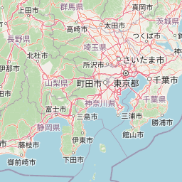
Fuji-Hakone-Izu National Park Geography: Mapped Boundaries, Terrain, and Natural Features
This geographic profile covers the extensive landscape and mapped boundaries of Fuji-Hakone-Izu National Park across Yamanashi, Shizuoka, Kanagawa, and the Tokyo Metropolis. The data details a protected area spanning over 1227 square kilometers, encompassing diverse terrain from volcanic peaks and mountain saddles to coastal waterfalls and alpine meadows.
Related tags
volcanic landscapehot springsislandsmountain landscapecoastal scenery
Japan's most visited national park encompassing Mount Fuji, volcanic hot springs, and the Izu Islands chain
Fuji-Hakone-Izu National Park
Fuji-Hakone-Izu National Park is a vast and remarkably diverse protected area in central Japan, spanning portions of Yamanashi, Shizuoka, and Kanagawa Prefectures along with western Tokyo and extending hundreds of kilometers south through the Izu Islands into the Pacific Ocean. The park was established in 1936 as one of Japan's inaugural national parks and originally encompassed only Mount Fuji and the Hakone region before the Izu Islands were added in 1950, prompting the name change. At its heart stands Mount Fuji, Japan's highest peak and an iconic cultural symbol, surrounded by the scenic Fuji Five Lakes that offer some of the most photographed views of the mountain. The park encompasses an extraordinary range of geographic features including volcanic mountains, natural hot springs, deep forest valleys, coastal cliffs, and more than 1,000 volcanic islands. The Izu Peninsula and Izu Islands provide subtropical environments distinct from the alpine zones around Mount Fuji, with vegetation transitioning from mountain forests to tropical plant communities on the southern islands. Due to its extraordinary concentration of natural landmarks and its proximity to the Tokyo metropolitan area, Fuji-Hakone-Izu is the most heavily visited national park in Japan.
- Location
- Japan
- Park type
- National park
- Established
- 1936
- Area
- 1,227 km²
Location overview
Regional jurisdictions and coastal status across Japan and American Samoa
Mapped Geography and Regional Borders of Fuji-Hakone-Izu National Park
Fuji-Hakone-Izu National Park spans coastal protected territory across Japan and American Samoa. Regional mapping details administrative bounds across Tokyo Metropolis, Kanagawa, Shizuoka, and Yamanashi Prefectures.
- Countries
- Japan
- Regions
- Kanagawa Prefecture, Shizuoka Prefecture, Tokyo Metropolis, Yamanashi Prefecture
- Primary location
- Japan
- Geographic setting
- Coastal
Boundary and coordinates
Mapping the 1,227 square kilometer spatial extent and geographic boundary.
Geographic Boundary and Spatial Mapping for Fuji-Hakone-Izu National Park
Interactive outlines provide essential spatial context for the complex zones of Fuji-Hakone-Izu National Park. Registered measurements detail the estimated 1,227 square kilometer area, coordinate limits, and geographic center.
- Boundary area
- 1,132.8 km²
- Boundary perimeter
- 871.8 km
- Northernmost point
- 35.5723° N
- Southernmost point
- 34.5626° N
- Easternmost point
- 139.1602° E
- Westernmost point
- 138.5282° E
- Geographic centre
- 35.1849° N, 138.8161° E
- North–south span
- 112 km
- East–west span
- 57.7 km
Terrain and natural features
Mixed relief classifications and recorded natural landmarks
Fuji-Hakone-Izu National Park Terrain and Mapped Natural Features
Fuji-Hakone-Izu National Park exhibits a mixed mountain relief classification across its protected terrain. Linked feature cards supply names, types, and spatial relationships for recorded natural landmarks.
Selected named natural features
Rivers
西川
Streams
中の沢
Waterfalls
幻の滝
Peaks
雨ヶ岳
1,771.6 m
Peaks
弓射山
1,566 m
Environmental setting
Interpreting recorded landscape features, habitats, relief, and climate zones
Fuji-Hakone-Izu National Park Environmental Classifications and Physical Setting
Recorded habitat types, landscape features, and climate zones serve as interpretive categories for reading physical terrain across Fuji-Hakone-Izu National Park. Stored classifications connect directly to broader protected area records within the regional atlas navigation.
- Relief
- Mixed relief
- Climate
- Subtropical
- Water
- Major water bodies
- Forest cover
- Partial forest
- Seasonality
- Year-round
Landscape features
Mountains · Lakes · Rivers · Waterfalls · Coast · Beach · Islands · Volcano · Forest · Wetland · Cliffs
Habitat types
Temperate broadleaf forest · Montane forest · Alpine meadow · Wetland · Riverine habitat · Coastal habitat · Marine habitat
Park atlas
Compare surrounding protected areas; trace volcanic landscapes, hot springs, and island ecosystems.
Explore Other National Parks and Protected Areas Near Fuji-Hakone-Izu National Park
After exploring Fuji-Hakone-Izu National Park, browse other national parks and protected areas across central Japan, extending from its volcanic mountains to its subtropical islands. This atlas-style view allows for detailed comparison of diverse conservation landscapes, revealing connections between distinct regional park geographies.
National parkChūbu region
About 35 km away#1 closest
Northwest

Minami Alps National Park: A Protected Alpine Wilderness in Japan's Chūbu Region
Discover its dramatic peaks and vital river headwaters.
Minami Alps National Park offers a profound exploration into Japan's high-altitude natural geography. As a national park, it preserves a dramatic alpine environment defined by glacially carved terrain and multiple peaks exceeding 3000 meters. This protected landscape serves as a vital watershed, safeguarding the origins of major river systems and showcasing a rugged mountain character distinct from more accessible areas, ideal for understanding protected wildlands.
- Area
- 357.52 km²
- Established
- 1964
- IUCN
- II
- Relief
- Mountain
National parkSaitama Prefecture
About 37 km away#2 closest
North
Chichibu-Tama-Kai National Park: Mapped Protected Landscape and Regional Geography
Explore the geographic identity of this national park.
Discover Chichibu-Tama-Kai National Park through its protected landscape features and geographic setting. This page provides detailed atlas context, focusing on the park's mapped boundaries and its contribution to the regional geography of Saitama Prefecture. Understand the unique character and structural significance of this national park for comprehensive geographic discovery.
- Area
- 1,216 km²
- Established
- 1950
- IUCN
- II
- Relief
- Mountain
National parkJapan
About 118 km away#3 closest
North
Jōshin'etsu-kōgen National Park: Protected Landscape and Regional Geography Atlas
Explore the mapped boundaries and geographic identity of this national park.
Jōshin'etsu-kōgen National Park represents a vital protected area within Japan, offering rich opportunities for geographic discovery through its mapped landscape. This entry provides detailed context on its protected boundaries and its relation to the surrounding regional geography, perfect for atlas-based exploration of natural terrains and conservation landscapes. Understand the unique geographic setting of this important national park.
- Area
- 1,481.94 km²
- Established
- 1949
- IUCN
- II
- Relief
- Mountain
National parkChūbu region
About 157 km away#4 closest
Northwest
Chūbu-Sangaku National Park: Japan's Iconic Alpine Protected Landscape and Northern Alps Atlas
Rugged peaks, alpine valleys, and mapped geography.
Chūbu-Sangaku National Park represents Japan's most significant alpine protected area, encompassing the dramatic heart of the Hida Mountains, or Northern Alps. Established in 1934, this national park is celebrated for its towering peaks, deep gorges, and as the source of Japan's longest river. Its rugged terrain offers unparalleled opportunities for exploring mapped alpine landscapes and understanding the geography of Japan's most prominent mountain wilderness.
- Area
- 1,743.23 km²
- Established
- 1934
- IUCN
- II
- Relief
- Mountain
National parkKantō region
About 157 km away#5 closest
North
Oze National Park National Park: A Key Protected Landscape in the Kantō Region
Explore its mapped geography and protected area context.
Oze National Park is a designated national park in Japan's Kantō region, offering a prime example of a protected landscape. This page provides detailed insights into its geographic setting and mapped boundaries, contributing to a structured understanding of regional natural terrain. Users can delve into the park's specific identity as a conservation area and its significance within the broader atlas of Japanese geography and protected lands.
- Area
- 372.22 km²
- Established
- 2007
- IUCN
- V
- Relief
- Mixed relief
National parkJapan
About 159 km away#6 closest
North
Myōkō-Togakushi Renzan National Park: Mapped Protected Landscape Geography in Japan
Explore the park's regional terrain and protected area context.
Delve into the geographic specificities of Myōkō-Togakushi Renzan National Park, a key protected landscape in Japan. This entry focuses on its mapped terrain, regional setting, and the atlas-value of understanding its protected boundaries. Gain clarity on the park's distinct natural geography and its contribution to the broader protected area network.
- Area
- 397.72 km²
- Established
- 2015
- IUCN
- II
- Relief
- Mountain
National parkTochigi Prefecture
About 165 km away#7 closest
North
Nikkō National Park: Discover its Protected Landscape and Regional Geography
Explore mapped boundaries and natural terrain within Tochigi Prefecture.
Understand Nikkō National Park as a key protected area within the geography of Tochigi Prefecture. This dedicated page provides an atlas-style overview of its natural landscape, mapped contours, and significance. Users can gain insights into the park's protected status and its placement within Japan's diverse natural regions, fostering a deeper appreciation for its geographic context.
- Area
- 1,149.08 km²
- Established
- 1934
- IUCN
- II
- Relief
- Mountain
National parkIshikawa Prefecture
About 178 km away#8 closest
Northwest
Hakusan National Park: Sacred Mountain Protected Landscape in Ishikawa Prefecture
Mapped alpine terrain and volcanic geography for protected area discovery.
Hakusan National Park offers a unique exploration of Japan's sacred mountain heritage and alpine natural beauty. This protected landscape, centered on Mount Haku, features distinct volcanic terrain, crater lakes, and exceptional alpine flora. Users can explore the park's mapped boundaries, understand its place within Ishikawa Prefecture's geography, and appreciate its role as a significant UNESCO Biosphere Reserve for detailed atlas-based discovery.
- Area
- 477 km²
- Established
- 1962
- IUCN
- II
- Relief
- Mountain
MoriAtlas Explorer
Continue Exploring the Geography and Protected Landscapes of Fuji-Hakone-Izu National Park
Deepen your understanding of Fuji-Hakone-Izu National Park by exploring its detailed geography, mapped protected area boundaries, and distinct landscape features. This extensive natural area offers a wealth of information for anyone interested in Japanese national parks and regional landscape discovery through structured atlas data.
Browse next
Global natural geography
Explore related park routes
Explore MoriAtlas Global ParksBrowse All MoriAtlas ParksGlobal Park Map DiscoveryMoriAtlas: Browse All CountriesBrowse All MoriAtlas ContinentsNational Park Environment AtlasGrand Canyon National Park AtlasYellowstone National Park AtlasYosemite National Park Atlas and GeographySerengeti National Park AtlasGalápagos National Park Protected LandscapeBanff National Park Geography and AtlasKruger National Park Atlas EntryUluṟu-Kata Tjuṯa National Park AtlasExplore Uluru-Kata Tjuta National Park GeographyPlitvice Lakes National Park AtlasFiordland National Park Protected LandscapeGreat Smoky Mountains National Park AtlasAfghanistan National Parks and Protected AreasAlbania National Parks and Protected AreasAlgeria National Parks and Protected AreasAmerican Samoa National Parks and Protected AreasAndorra National Parks and Protected AreasAngola National Parks and Protected AreasAntarctica National Parks and Protected AreasAntigua and Barbuda Park List