

Mori Atlas logo
National parkGa'an Libah National Park

Discover the mapped boundaries and regional setting of this national park.

Ga'an Libah National Park: National Park Protected Landscape and Geographic Identity

Ga'an Libah National Park stands as a significant protected area, identified as a national park to conserve its unique natural landscapes. This page provides an in-depth exploration of its geographic features, mapped extent, and its role within the broader regional context. Understand the atlas value and distinct park geography that defines Ga'an Libah National Park, offering a factual foundation for protected land discovery.

protected areanature reservewildlife conservationeast africa

Ga'an Libah National Park

National park

Park overview

Structured park overview, official facts, and landscape profile for Ga'an Libah National Park

Ga'an Libah National Park park facts, protected area profile, and essential visitor context

Review the core facts for Ga'an Libah National Park, including designation, size, terrain, visitor scale, habitats, and operating context in one park-focused overview.
Monthly climate preview

Long-term representative point measurements for temperature and monthly precipitation averages

Ga'an Libah National Park Climate Normals and Annual Temperature Rhythm

Representative coordinates record long-term temperature ranges between 20.27 °C and 28.82 °C alongside varying monthly precipitation levels at an elevation of 852.3 meters. Examining the complete twelve-month climatology profile reveals broader multi-month thermal trends and detailed precipitation shifts across the protected landscape.
Annual mean25 °C
20 °C29 °C
Jan20°
Feb22°
Mar24°
Apr26°
May28°
Jun29°
Jul28°
Aug28°
Sep29°
Oct25°
Nov22°
Dec20°
Warmest month
June

28.8 °C

Coolest month
December

20.3 °C

Wettest month
April

2.4 mm/day

Driest month
January

0.4 mm/day

Park location guide

Geography guide, regional context, and park location map for Ga'an Libah National Park

Ga'an Libah National Park park geography, regions, and map view in Somalia

Understand where Ga'an Libah National Park sits in Somalia through a broader geographic reading of the surrounding landscape, nearby location context, and its mapped position within the national park landscape.

How Ga'an Libah National Park fits into Somalia

Somalia is a federal parliamentary republic located at the easternmost point of continental Africa. Formerly colonised by Britain and Italy, it gained independence in 1960 when British and Italian Somaliland merged. The country has endured prolonged civil conflict since 1991 but has recently stabilised under a federal government. Mogadishu serves as both the capital and largest city.

Wider geography shaping Ga'an Libah National Park in Somalia

Somalia occupies the Horn of Africa region, stretching along the eastern coast of the continent. It borders Ethiopia to the west, Djibouti to the northwest, Kenya to the southwest, the Gulf of Aden to the north, and the Indian Ocean to the east. The terrain is predominantly arid plains and plateau, with the Juba and Shabelle rivers in the south.

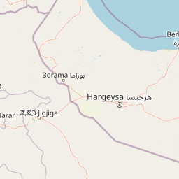
Map view of Ga'an Libah National Park

Use this park location map to pinpoint Ga'an Libah National Park in Somalia, understand its exact geographic position, and read its mapped placement within the surrounding landscape more clearly.

Pigeon | © OpenStreetMap contributors
Park atlas

Discover related conservation landscapes, tracing the regional spread of protected areas surrounding Ga'an Libah.

Explore Other National Parks and Protected Areas Near Ga'an Libah National Park

After exploring Ga'an Libah National Park, browse other national parks and protected areas across the surrounding regional geography, comparing their unique features. This atlas view reveals broader protected-landscape context and highlights adjacent wildlife conservation efforts for comprehensive park exploration.
National parkTadjourah Region
About 317 km away#1 closest

Northwest

Day Forest National Park: Ancient Juniper Woodland and Protected Landscape in Djibouti

Discover a rare East African forest refuge with unique endemic species.

Day Forest National Park represents a critical ecological island within Djibouti's predominantly semi-desert geography. As the nation's oldest national park, it protects the largest remaining East African juniper forest, a vital sanctuary for species found nowhere else on Earth. Located in the Goda Mountains of the Tadjourah Region, its existence relies on rare localized rainfall, creating a distinctive mountainous forest environment that offers profound insights into protected landscape dynamics and regional biodiversity.

Area
15 km²
Established
1939
IUCN
II
Relief
Mountain
National parkDjibouti
About 348 km away#2 closest

Northwest

Yoboki National Park: Djibouti National Park Geographic Atlas Explorer

Discover its mapped boundaries and regional terrain.

Yoboki National Park is a key protected area within Djibouti, offering a distinct focus for geographic exploration. This entry provides structured information to understand the park's mapped landscape and its position within the Horn of Africa's regional geography. Delve into the park's protected land identity and terrain context, essential for atlas-based discovery and appreciating its natural features.

IUCN
II
Relief
Mixed relief
Climate
Arid
Scope
Terrestrial
National parkAfar Region
About 431 km away#3 closest

West

Yangudi Rassa National Park: Protected Semi-Desert National Park in Afar Region

Mapped landscape and dryland ecosystems.

Yangudi Rassa National Park represents a critical protected area within Ethiopia's Afar Region, covering extensive semi-desert and grassland terrains. The park's geography is marked by Mount Yangudi and the broad Rassa Plains, with the Awash River shaping its riverine forests and marshes. This national park offers a unique insight into dryland ecosystems and their conservation, providing a distinct mapped landscape for geographic study and exploration.

Area
4,731 km²
Established
1969
IUCN
II
Relief
Mixed relief
National parkEthiopia
About 535 km away#4 closest

West

Awash National Park: Mapped Protected Boundaries and Ethiopian Regional Geography

Discover the protected landscape of this Ethiopian National Park.

Awash National Park represents a significant protected area within Ethiopia, offering a rich focus for geographic discovery. This page illuminates the park's specific mapped boundaries and its positioning within the surrounding regional geography. It serves as a detailed entry point for understanding the park's landscape character and its role as a national park in East Africa.

Area
850 km²
Established
1966
IUCN
II
Relief
Mixed relief
National parkBale Zone
About 625 km away#5 closest

Southwest

Bale Mountains National Park National Park: Explore Protected Landscape and Regional Geography

Mapped boundaries and natural terrain context for this Ethiopian park.

Delve into Bale Mountains National Park, a designated national park in Ethiopia's Bale Zone, focusing on its role as a vital protected landscape. This page offers detailed insights into the park's mapped boundaries and its contribution to the regional geography, providing a foundation for structured atlas exploration of protected areas and natural terrain. Understand the geographic significance and landscape identity of this key conservation entity within the broader context of Ethiopia's natural heritage.

Area
2,220 km²
Established
1970
IUCN
II
Relief
Mountain
National parkArsi Zone
About 653 km away#6 closest

West

Arsi Mountains National Park: Protected Ethiopian Highlands Landscape & Geography

Mapped protected terrain and endemic species habitat within the Arsi Zone.

Arsi Mountains National Park is a vast protected area celebrated for its significant biodiversity and distinctive Afro-alpine ecosystems. Situated in the Arsi Zone, this national park encompasses a dramatic mountain landscape central to the Ethiopian Highlands. It serves as a crucial refuge for endangered endemic species, including the mountain nyala and Ethiopian wolf, within its varied ecological zones and protected park boundaries, offering rich context for geographic exploration.

Area
10,876 km²
Established
2011
IUCN
II
Relief
Mountain
National parkSomalia
About 710 km away#7 closest

East

Ras Hafun National Park: Somalia's Protected Coastal Landscape and Geographic Atlas Entry

Explore mapped boundaries and regional natural landscapes.

Ras Hafun National Park serves as a focal point for understanding Somalia's protected natural areas and their geographic distribution. As a national park, it offers a distinct landscape entity to analyze within the atlas of the Horn of Africa. This MoriAtlas entry highlights the park's spatial definition and its significance as part of the country's conserved environments, providing essential context for regional geography and mapped terrain exploration.

Area
2,571 km²
Relief
Lowland
Climate
Arid
Access
Access unknown
National parkMiddle Juba
About 719 km away#8 closest

South

Jilib National Park: National Park with Mapped Protected Boundaries

Geographic context within Middle Juba.

Examine Jilib National Park as a significant protected natural area. This national park's identity is rooted in its specific geographic location within the Middle Juba region. The atlas-focused presentation details its mapped boundaries and landscape context, allowing for precise exploration of its protected status and regional significance. Understanding Jilib National Park contributes to a broader appreciation of Somalia's conservation geography.

Area
950 km²
Established
1970
IUCN
II
Visitors
300 annual

Common questions about visiting, size, designation, and location context for Ga'an Libah National Park

Ga'an Libah National Park FAQs for park facts, access, geography, and protected area context

Find quick answers about Ga'an Libah National Park, including protected-area facts, park geography, trail and visitor context, and how the park fits into its surrounding country and regional landscape.
MoriAtlas Explorer

Continue Your Protected Areas Search Across the Global Atlas

Deepen your exploration by continuing the structured search for national parks and protected areas worldwide. Utilize the comprehensive filtering capabilities to compare different conservation landscapes and refine your understanding of global park geography. Discover more about the distribution and characteristics of protected natural areas.

Global natural geography
